-
Joseph Burr Tyrrell
Encyclopedia Arctica 15: Biographies
001 | Vol_XV-0828
EA-Biography
(D. M. LeBourdais)
JOSEPH BURR TYRRELL
Joseph Burr Tyrrell (1858 - ), Canadian explorer, geologist, and
mining engineer, was born at Weston, Ontario, on November 1, 1858, son of
William and Elizabeth (Burr) Tyrrell. He received his education at the
Weston Grammar School, Upper Canada College, Toronto, and the University
of Toronto, from which he was graduated in 1880. The law was his first
choice, but after a year at Osgoode Hall, the law school of the University
of Toronto, he was found to have tuberculosis, one lung being already partly
destroyed.An out-of-doors occupation thus became imperative, and he secured a
position with the Geological Survey of Canada at the modest salary, to begin
with, of $500 a year. His first task consisted of classifying some of the
accumulated specimens at Survey headquarters in Ottawa.Tyrrell's field work began in 1883, when he accompanied Dr. G. M. Dawson,
later Director of the Survey, on an exploration of the Rocky Mountains in
the territories of Alberta and Assiniboia (now the Province of Alberta) and
the Province of British Columbia, between the parallels of 49° and 51° 30′ North.
The Crow's Nest Pass, North and South Kootenay Passes, and Kicking Horse Pass
were explored geologically and geographically, providing a series of sections,
running in each case completely across the Rocky Mountain range. Dawson and
Tyrrell explored what later became known as the Rocky Mountain Trench, lying
between the Rockies and the Selkirk Range, in which the Columbia and Kootenay
002 | Vol_XV-0829
EA-Biog. LeBourdais: Joseph Burr Tyrrell
rivers flow in opposite directions. The valley was examined in a preliminary
manner from the mouth of Kicking Horse River to the International Boundary,
a distance of about 200 miles. While Dawson did the geology, Tyrrell paced
the distance and did part of the geographical survey. He was also responsible
for fossils and rock specimens, and gathered in addition a large collection
of plants. In the Crow's Nest Pass he discovered coal seams that have since
been developed into important mines at Fernie, B.C.Next year Tyrrell was for the first time given charge of a survey party.
In the summers of 1884, 1885, and 1886, he carried on a survey of the country
north of Calgary, between the Bow and North Saskatchewan rivers, comprising
an area of about 27,000 square miles lying between 110° and 115° West Longi–
tude. m M any coal seams were examined, in addition to which other geological,
geographical, and topographical information was gathered, as well as informa–
tion concerning the condition of the soil, the amount of timber, and the
extent of grazing land.During the years 1887 to 1891, inclusive, Tyrrell conducted surveys in
northwestern Manitoba, chiefly in the Riding and Duck mountain regions and
about Lakes Winnipeg, Manitoba, and Winnipegosis. In 1880, he examined and
reported upon an extensive deposit of gypsum which he predicted would one
day provide the surrounding country with material for plaster. Later in the
same season, he was taken ill with typhoid and carried out to hospital at
Winnipeg, where he remained for the rest of the season. The data secured
during these years provided material for subsequent studies of the movement
of ice during glacial times and of the presence and extent of inter- and
post-glacial [ ?] lakes.The following year, 1892, Tyrrell was sent into a new area. Crossing
003 | Vol_XV-0830
EA-Biog. LeBourdais: Joseph Burr Tyrrell
the Saskatchewan River at Prince Albert, he proceeded by wagon up the Shell
River valley to Green Lake, where canoes were secured. A survey was made
of that lake with compass and boat log, thence down Beaver River to Isle
a la Crosse Lake, and from there to the Churchill River, which was reached
on June 29.The Churchill was descended to the mouth of the Mudgatick River, which
was ascended to the height of land and across the portage to Cree Lake,
fifty miles in length, which was found to lie along the line of contact of
the Paleozoic with the Archaen rocks.Tyrrell then proceeded down Cree River, which flows out of the north
end of the lake, through Wapato Lake to Black Lake, and thence by way of
Stone River to Lake Athabaska, where, at Fond du Lac, on the north shore
of the lake, he replenished his supplies at the Hudson's Bay Post.Leaving Fond du Lac on July 27, Tyrrell surveyed the north shore of
Lake Athabaska to its eastern end, thence back up Stone River, and by way
of Black Lake and River to Wollaston Lake. It was found that Wollaston Lake
was astride the Mackenzie and Hudson Bay watersheds, some of its waters
draining into the former through Lake Athabaska, while from the opposite side
of the lake its waters flowed toward Hudson Bay by way of the Churchill through
Reindeer Lake.Then, in 1893, in company with his brother, James W. Tyrrell (q.v.), he
undertook his most important exploratory journey, from Lake Athabaska to Hudson
Bay, when the whole area beyond Black Lake to the northeast was pratically
a blank on the map; and, except for what they were about to add, was to remain
largely so until the coming of the airplane. Accompanied by four Indians,
three of whom were Iroquois from [ ?] eastern Canada, they launched their
004 | Vol_XV-0831
EA-Biog. LeBourdais: Joseph Burr Tyrrell
Peterborough canoes at Athabaska Landing, on the Athabaska River, 100 miles
by wagon road from Edmonton. They traveled light, as their outfit had been
shipped ahead by Hudson's Bay Company's steamer to await them at Fort Chipe–
wyan, on the north shore of Lake Athabaska, near the western end.An Indian guide with a third canoe was hired at Chipewyan, and on
June 21 the party headed for the eastern end of the lake. Reaching there
on July 1, they began the ascent of Stone River. Two very rough portages,
one three miles and the other three and a half miles, made necessary six
trips each way before the entire outfit of 4,000 pounds was brought across.
Black flies were out in strength, which reminded James Tyrrell of the Indian
legend that it was on these very portages that the Great Spirit first made
the black flies. J. B. Tyrrell had traveled up and down Stone River from
Black Lake to Lake Athabaska, the previous year, but his canoes had then
been less heavily laden.From river to lake and from lake to river, the course from Lake Atha–
baska to the height of land was a continuous succession of portages. The
course from Black Lake was almost due north. Just before the divide was
reached they entered a large lake, too wide for both shores to be sketched
from their line of travel, and they accordingly traversed its east side only.
To this lake they gave the name Selwyn, after the Director of the Geological
Survey. The lake proved to be about fifty miles long. At its farther end
they found the portage leading northward over the height of land to the shore
of another large lake, which they named Daly, after the Dominion Minister
of the Interior. The portage, which wound between hills two or three hundred
feet high (fourteen or fifteen hundred feet above sea level) was a mile and
a quarter in length. Daly Lake was found to be fifty feet lower than its
companion to the south.
005 | Vol_XV-0832
EA-Biog. LeBourdais: Joseph Burr Tyrrell
The brothers reached Daly Lake on July 18. Four days later they
located its outlet, source of the Dubawnt River, which they expected would
lead them to Baker Lake, Chesterfield Inlet, and Hudson Bay. The river
was broad and swift, divided into many channels, its course mainly northward.
Although many rapids were encountered, few required portaging (their Iroquois
delighted in running them!). The river seemed like a cord strung through a
succession of lakes. They had reached the north end of one of these, which
they named Barlow, on July 28, when they sighted their first caribou, the
only game they had so far seen on the trip; and, since they were getting
short of food, this was a welcome encounter.Next day, however, as they were paddling through another considerable
lake, which they named Carey, moving figures were noticed on shore, which
upon investigation proved to be caribou. "The valleys and hills for miles
appeared to be moving masses of caribou," wrote James Tyrrell. "To estimate
their numbers would be impossible. They could only be reckoned in acres or
square miles." He has since said that there were many hundreds of them and
perhaps over a million. To replenish the larder was now the main business,
and several days were spent drying meat.On August 3, the outlet of Carey Lake was located, but the river imme–
diately rushed down a rapid with about thirty feet of fall, followed within
about twenty miles by seven other rapids with an aggregate drop of about 120
feet. This brought them to the level of Markham Lake, named in honor of
Admiral A. H. Markham, R.N. After passing through this lake they once more
proceeded down the river, running six rapids for a total fall of over 100 feet.Dubawnt Lake was reached on August 7. It had been sighted by others than
natives only once previously — by Samuel Hearne on his journey to the Copper–
mine, more than a century before. Ice still covered most of its surface, but
they were able to proceed along the shore, forced occasionally to stop because
006 | Vol_XV-0833
EA-Biog. LeBourdais: Joseph Burr Tyrrell
of the ice moving in ahead of them. Stormy weather also caused delays; and,
as usual, the outlet was hard to find. It was not located till the evening
of the 17th. The following morning they were on their way again, but not
for far; about six miles from the lake's outlet, the river rushes down a
rocky gorge, not more than fifty yards in width, and continues for two and
a half miles, after which it widens into another lake.They crossed this lake on the 19th, and went on down the Dubawnt, now
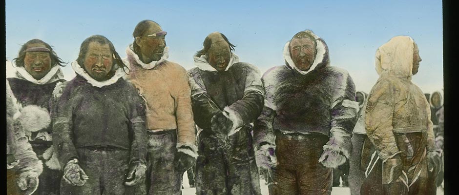
broad and swift. That evening an Eskimo tent was seen on the river bank.
At sich of the three canoes coming down their river, the women and children
scurried inside, while a lone man stood guard outside. When however, assurances
had been given that these visitors were friendly, those inside — two wives
and six children — came running out to extend typical Eskimo hospitality.
They had in their possession articles secured in trade from other Eskimos
who had procured them from the Hudson's Bay Company's posts, either at Churchill
or Marble Island. They sketched the river's course below, thus removing any
doubts as to its destination.The river continued to be the connecting link between a succession of
lakes, but its course lay so far to the north and west that by the 25th,
despite the Eskimos' assurances, they wondered whether, after all, it did
flow into Baker Lake, especially since they had now passed beyond its latitude.
That evening, however, a change occurred in the nature of the stream; the banks
became lower, consisting of soft, coarse-grained sandstone. What [ ?] surprised
them was the presence of quantitie d s of driftwood, some of it consisting of
spruce logs six to eight inches in diameter, such as they had not seen for a
long time. This was explained when they reached the mouth of a large tributary,
equal in sixe to the Dubawnt itself, flowing in from the west. Now known as
007 | Vol_XV-0834
EA-Biog. LeBourdais: Joseph Burr Tyrrell
the Thelon, it runs in its upper reaches for nearly two hundred miles through
wooded country.Next day, the river still ran northward; but in latitude 64° 41′ North
it finally swung to the east, then southeast, and spread into the broad ex–
panse of Aberdeen Lake, named by Tyrell after the then Governor General of
Canada. Searching for the outlet from the lakes they encountered had been
all along one of their chief causes of delay, and finding the outlet of
Aberdeen Lake was no exception. However, on the evening of the 28th, they
again discovered the river. Next morning they proceeded on their way and
by noon had entered another lake, which they named Schultz. Its outlet they
found to be in latitude 64° 48′ North, the highest latitude reached on their
journey. On September 3rd, as they were paddling down the river, now about
three hundred yards wide, they encountered an Eskimo encampment of several
tents, where they were cordially received. Farther down they came on a large
Eskimo village.Shortly after leaving the village, the canoes emerged upon the waters
of Baker Lake, which is about seventy miles in length and about half that
across. According to their calculations, they had traveled, since leaving
Black Lake, eight hundred and ten miles through an entirely unknown country.
Their astronomical observations showed that the extremity of Baker Lake, as
placed on existing maps of Canada, was nine miles too far south and about
fifty miles too far west. Later explorations established that the Dubawnt and
Thelon rivers together are navigable for river or York boats for a distance of
three hundred and seventy-four miles above Baker Lake, with few rapids where
portaging is necessary.From the western end of Baker Lake to the mouth of Chesterfield Inlet the
distance is two hundred and fifty miles, and this they covered between September 3rd
008 | Vol_XV-0835
EA-Biog. LeBourdais: Joseph Burr Tyrrell
and 12th. From there the next stage was a five-hundred-mile voyage southward
along the low-lying coast of Hudson Bay. In good weather, with experienced
paddlers and lightly loaded canoes, such a trip might easily have been made
in a week or little more; but at that time of year, on such an exposed shore,
everything was against travel by canoe.Tyrrell has said that the worst rapids he has ever run in a canoe were
along the Hudson Bay coast when the tide was rushing out. The slope of the
beach is almost imperceptible, but it is broken by sudden drops over ledges
and further complicated by scattered boulders. Ebb and flow are like tidal
waves, and only expert canoemanship often prevented destruction of the canoes
when caught in their flood.From time to time the party secured a little game; the total was barely
enough to keep them alive and provide energy for traveling and battling with
the elements. As September wore on and October began, much ice formed along
the shore, sometimes making it difficult for the travelers to reach land at
night. Finally, on October 14, the shore ice extended so far out and was so
broken that they were unable to reach land at all and were compelled to remain
in their canoes all night. Only continuous bailing kept the canoes afloat
and everyone was soaked with icy water.In the morning they made their way to the landfast ice, across which
they carried their canoes and thus reached solid ground, where camp was made
in a clump of spruce trees — for they had now reached wooded country. Having
a fire again was a great luxury. One of the Indians had both feet frozen and
all were suffering from exposure and lack of food.For most of them, further travel was out of the question. Two of the
Indians were in better condition than the rest of the party and it was decided
that they should go on foot to Churchill and get help. They left camp on
009 | Vol_XV-0836
EA-Biog. LeBourdais: Joseph Burr Tyrrell
October 16. Three days later they returned with dog sleds and provisions.
Soon everybody was being cared for at Churchill.It was still about a thousand miles to the nearest railway station.
After seventeen days spent in recuperation at Churchill, and in making
preparations for a resumption of the journey, they set off for the south
on snowshoes, their outfit hauled by dogs. York Factory, at the mouth of
the Hayes River, was their first objective. Normally a nine-day journey,
they were delayed ten days in getting across the Nelson River, not yet
frozen over and running a great deal of ice. Consequently it was November
24 before they reached York.The next objective was Oxford House, two hundred and fifty miles up
the Hayes, which they made without undue difficulty; and then on to Norway
House, near the top of Lake Winnipeg, another one hundred and fifty miles.
The going was good, and as their supplies lessened they were able to ride
in the sleds. On New Year's Day, 1894, ten days after leaving Norway House,
their dog teams trotted into West Selkirk, Manitoba. The telegraph soon
carried welcome news to anxious relatives, since for some time considerable
concern had been felt for their safety and the Government had sent out a
search party that lad already returned without news.This journey, comprising a canoe and snowshoe trip of three thousand
two hundred miles, is described rather more fully than Tyrrell's other
expeditions because of its importance from a geographical standpoint, and
also because it shows the difficulties with which he and other surveyors
were forced to contend in exploring and charting the then largely unknown
western and northern areas of Canada.In 1894, Tyrrell was off on another northern journey. This time his
010 | Vol_XV-0837
EA-Biog. LeBourdais: Joseph Burr Tyrrell
route led northward through Reindeer Lake to Cochrane River, thence across
a height of land to Kasha Lake, which he reached on August 5. This lake he
estimated to be about two hundred and twenty-one miles from Reindeer Lake,
in which distance there had beenfifty-three portages. Proceeding northeast–
ward down a river which he feared might lead him to Baker Lake and Chester–
field Inlet, he took a portage route southeastward from latitude 63° 7′ North
to the Ferguson River and descended that stream to Hudson Bay, which he
reached on September 18. Once more a long canoe journey must be made down
the open coast, but this time the season was earlier, and on October 1
Churchill was reached. Tyrrell estimated the distance traveled from Reindeer
Lake to Hudson Bay at eight hundred and fifteen miles, the total distance in
canoes over seventeen hundred miles.During the following three years Tyrrell worked in the territory north
of Lake Winnipeg and eastward to the Bay, through which region the Hudson
Bay Railway now runs. Among other things, these journeys established that
in Pleistocene time there had been a center of glaciation west of Hudson
Bay from which a continental ice mass, which was named the Keewatin Glacier,
had spread out in all directions.In 1897 Tyrrell was asked to act as one of the secretaries of the
geographical section of the British Association, meeting that year in Toronto.
He read two papers, one on "The Glaciation of North Central Canada," the
other on "The Physical Geography of the Barren Lands of Canada." In that
year, too, news of a fabulous gold strike in the Yukon — the Klondike — was
blazoned to the world. The Geological Survey sent him to Dawson City the
following spring. He went in by way of Haynes, Alaska, spent the summer in the
Yukon, and returned to Ottawa in the fall, shortly after which he resigned from
011 | Vol_XV-0838
EA-Biog. LeBourdais: Joseph Burr Tyrrell
the Survey. He and the then Minister of the Interior, Hon. (later Sir)
Clifford Sifton, did not see eye-to-eye on matters of policy.Tyrrell went back to Dawson in 1899, going in this time by way of
Skagway and the Chilkoot Pass, to engage in private practice as a mining
engineer. He was there five years and during that time reported on some
of the principal properties in the district — and on many that did not
turn out so well. His sojourn in the Yukon added much to geological knowledge.In 1906 he established himself in Toronto as a mining engineer. At
that time the great mineral wealth of northern Ontario and Quebec, to say
norhing of the Northwest, was largely unsuspected. It is true the nickel
deposits of Sudbury were known, and sensational silver had been discovered
at Cobalt, but the secrets of Porcupine, Kirkland Lake, and Noranda were
still locked in their granite fastnesses.Tyrrell's life from now on was mostly associated with the opening up
of this great mineral storehouse; but in 1912 he was induced to undertake
an exploratory expedition for the Province [ ?] of Ontario. Shortly before
this the boundaries of Ontario and Manitoba had been extended to take in
large areas lying westward of Hudson Bay and, in the case of Manitoba, reach–
ing in latitude 60° North. The dividing line between Ontario and Manitoba
ran just south of the Nelson River. It was the territory newly acquired by
the Province of Ontario, and especially a fifty-mile strip along the Hudson
Bay coast between the mouth of the Nelson and the western bounda r y of Ontario,
that Tyrrell was asked to survey.At that time the Province of Ontario was contemplating the possibility
of a railway to Port Nelson, at the mouth of the Nelson River, then also
the expected terminus of the proposed Hudson Bay Railway from The Pas, which
was later diverted to Churchill. In anticipation, the Ontario Government
012 | Vol_XV-0839
EA-Biog. LeBourdais: Joseph Burr Tyrrell
had secured from the Province of Manitoba certain waterfront rights on the
river and bay and a right of way across Manitoba territory between the
Ontario boundary and the Nelson River. Tyrrell was to locate these lands
and rights; on his return journey he was to explore as much as possible of
the new territory just acquired by the province, obtaining such general
information as to its character, resources, and possibilities as he could.He and his party proceeded up Lake Winnipeg by steamer to Norway House.
From there they took canoes down the Nelson to the mouth of the Echimamish,
which flows into the Nelson from the east. They then followed that stream
to its source, and over a short, rocky divide to the Hayes River and down
to York Factory. A track survey was made, the distances on rivers and
smaller lakes being estimated, while the lengths of larger lakes were
measured by boat log.From York Factory the survey of the coastal region, both east and west
of the mouth of the Hayes, was undertaken. The location of a suitable site
for a railway crossing of the Hayes had also been requested, but it was
found necessary to go thirty-three miles up the river before such a site
could be found.The season was well advanced before all this was done and Tyrrell set
about returning through the new district as instructed. Taking passage on
a small sailing vessels of the Hudson's Bay Company, he and his party sailed
down the coast to the mouth of the Severn River, which took eight days.
They then hauled their canoes with lines up the Severan a distance of fifty-six
miles to the mouth of Fawn River, a beautiful clear stream one hundred and
fifty yards in width at its mouth. Up this stream, which with its lake system
roughly parallels the Severn, they tracked their canoes for one hundred and
013 | Vol_XV-0840
EA-Biog. LeBourdais: Joseph Burr Tyrrell
eighty miles, reaching Trout Lake on September 21. From then until the 13th of
October their course consisted of river, lake, portage, lake, river, portage,
etc., until they reached Cat Lake, in explored territory. Two more rivers,
one portage and two lakes brought them to Sioux Lookout, a station on the
National Transcontinental Railway, seven weeks from the mouth of the Severn
River. During the season, they had traveled one thousand, four hundred and
twenty-eight miles and negotiated one hundred and thirty portages. This was
J. B. Tyrrell's last exploratory expedition.Back in Toronto, at his profession, he was kept busy reporting on various
mining properties; and he had something to do with the beginnings of many of
the mines that are now big producers in Porcupine and Kirkland Lake. Even–
tually he became interested in the development of properties owned by Kirkland
Lake Mines, Limited. The owners had spent upwards of $1,000,000 but had not
discovered paying ore, although the property was adjacent to two of the most
promising mines in the Kirkland Lake camp. Believing that ore would be found,
but at a greater depth, Tyrrell called in an independent engineer to check his
conclusions and then agreed to arrange for the necessary financing. He became
president and managing director of the company; and ore was struck, as Tyrrell
had expected, at 1,800 feet. The mine has not been one of the spectacular ones,
but has since produced gold to the value of over $20,000,000, a profitable
venture for all concerned.Although still its president, Tyrrell has not of late years been so active
in the management of the mine. In order to keep occupied he had taken up apple
growing on a farm not far from Toronto. Although this enterprise was begun
after he was 70, he has lived to see his apple trees nature and produce fruit.
Like everything else he has undertaken, Dr. Tyrrell has entered into the business
of growing apples in a thorough manner and is far from being [ ?] an amateur
horticulturist.
014 | Vol_XV-0841
EA-Biog. LeBourdais: Joseph Burr Tyrrell
J. B. Tyrrell is a link with the Dominion's earliest days; he was nine
years old when it came into being. His father was a contemporary of the
Fathers of Conf ed eration and knew many of them intimately. In the mountains
and on the prairies before the railways were built, J. B., as he is often
called, has seen the settlement of the West and the opening of the North.At all times and wherever he has gone his has been the observant eye
and the inquiring mind. He has written many books and pamphlets; and while
he has stuck closely to his own field, his range of interests within that
field is wide, extending from the formation of ice on northern lakes to the
dates of arrivals and departures of ships in Hudson Bay.Since a good deal of his work has paralleled that of David Thompson,
the great explorer of fur-trade days, Tyrrell has been deeply interested in
Thompson's work, has edited his journal, and has done much to rescue him from
the obscurity that once enfolded him. He has also edited Hearne's and Turnan's
journals, with an introduction and valuable notes.Universities and learned societies have honored Tyrrell, and he has been
awarded many decorations, such as the Back Award by the Royal Geographical
Society in 1896; the Murchison Medal of the Geological Society of London, 1918;
the Daly Medal of the American Geographical Society of New York; the Flavelle
Medal of the Royal Society of Canada; and, in 1947, the Woolaston Medal of the
Geological Society of London. His alma mater has awarded him an honorary LL.D.
(1930), and Queen's University, Kingston, Ont., did likewise in 1940.D. M. LeBourdais