-
Petroleum Engineering
Encyclopedia Arctica 2b: Electrical and Mechanical Engineering
Petroleum in the Arctic
Unpaginated | Vol_IIB-0299
EA-I. (Wallace E. Pratt)
PETROLEUM IN THE ARCTIC
LIST OF FIGURES
Page Fig. 1 Map showing petroleum in the Arctic 2-a Fig. 2 Monthly temperatures and hours of daylight,
Barrow, Alaska11-a
001 | Vol_IIB-0300
E.A.-I (Wallace E. Pratt)
PETROLEUM IN THE ARCTIC
Any attempt to portray the petroleum resources of the Arctic should be
prefaced by the admission that our knowledge of the pertinent facts is but
fragmentary. No comprehensive study of petroleum in the Arctic of the West–
ern Hemisphere has been undertaken. Exploration for commercially valuable
accumulations has hardly begun. If studies and exploration in the arctic
regions of Europe and Asia are further advanced, as published statements of
Soviet scientists would indicate, the results have not been made known to the
outside world.To define the Arctic precisely and logically involves some explanation.
Neither the prevalence of low temperatures and extensive fields of ice, nor
a paucity of vegetation and other forms of life is a sufficient criterion.
Marine life abounds in arctic waters. Stefansson reminds us that winter
temperatures lower than any recorded on the arctic coast of Alaska have been
observed in Montana, a thousand miles farther south from the North Pole (8).
Much of the Arctic, even near the Pole, is free from ice and snow; large areas
of the “barren lands” of the Far North are actually grasslands and few arctic
areas are more barren than are the tropical deserts of western South America. ✓
To differentiate the arctic climate and environment from those of the temperate
zone requires the tracing of a sinuous and erratic dividing line. However,
for the purpose of examining the occurrences of petroleum in the Arctic, it
002 | Vol_IIB-0301
EA-I. Pratt: Arctic Petroleum
will serve arbitrarily to designate as arctic all that region which lies
north of the parallel of 60° N. latitude (see Fig. 1). ✓The North Pole lies near the center of an ext a e nsive intercontinental ✓
depression - a downwarped segment of the earth’s crust surrounded by the more
elevated land masses of the three continents, North America, Asia, and Europe.
This depression is occupied by a comparatively shallow body of water to which
many books and maps still refer as the Arctic Ocean. In reality the waters
surrounding the Pole constitute a landlocked sea, rather than an ocean. The
sea-like character of this body of water has long been recognized and it has
been referred to appropriately as the arctic Mediterranean (9:10).The character of the land areas of the Arctic as the margins of a medi–
terranean sea is, itself, significant in connection with their fitness to
contain accumulations of petroleum. The two greatest known petroleum prov–
inces on earth bear this same relationship to other mobile segments of the
crust, typically downwarped and occupied by Mediterranean seas, enclosed by
the positive elements of adjacent continents. The outstanding petroleum
province on earth consists of the vast petroleum accumulations of the Middle
East and the Union of Soviet Socialist Republics around the shores of the
Persian Gulf, the Caspian and Black seas, and the eastern end of the European
Mediterranean. These seas lie in a depressed belt which is squeezed between
the continental masses of Africa, Europe, and Asia. The American Mediterranean,
the Gulf of Mexico and the Caribbean Sea, occupying the depressed area between
the continents of North and South America, is the center of the second largest
of the earth’s known petroleum provinces. Finally, the great region of land–
locked seas lying between the continents of Asia and Australia, in the Far
002a | Vol_IIB-0302
Fig. 1
003 | Vol_IIB-0303
EA-I. Pratt: Arctic Petroleum
East, has also been proved to contain numerous large accumulations of petroleum.
Moreover, some of the geological processes which characterize the negative seg–
ments of the earth’s crust are also fundamental processes in the generation of
petroleum (5). In view of all these observations, it is reasonable, once we
recognize the Mediterranean character of the Arctic Sea, to anticipate the
occurrence of petroleum in the rocks which surround and contain it.In the basins of sedimentation which have comprised the arctic crustal
depression throughout much of earth history, a wide expanse and great volume
of marine sediments have been deposited. From the earliest Paleozoic through
the Cretaceous at the end of the Mesozoic, extended periods of sedimentation
have recurred over wide areas. As a consequence, the arctic coasts and the
broad continental shelves which underlie the marginal waters of the Arctic
Sea are constituted in large part of sedimentary rocks which appear to have
been laid down under conditions which were favorable for the generation of
petroleum. The prospect is enhanced by the geologic structure, favorable over
extensive areas, to the accumulation and retention in natural reservoirs be–
neath the surface, of any petroleum which may have formed in the rocks.It is true that very large areas of arctic terrain are composed of pre–
Cambrian crystalline rocks, which must be entirely devoid of petroleum. Much
of Greenland beneath the ice sheet falls in this category, as does all of
northeastern Canada, which includes much of the are a of dense crystalline rocks ✓
of the primitive continental shelf of North America. Scandinavia is also made
up principally of similar old crystallines. But elsewhere in North America, Europe,
and Asia the arctic rocks [ ?] are predominantly marine sediments, in fairly
complete sequence as far back as the Cambrian, representing deposition in a
004 | Vol_IIB-0304
EA-I. Pratt: Arctic Petroleum
number of extensive sedimentary basins. The organic content of the marine
facies appears to be of normal proportions and coal is present at several
different horizons in the fresh or brackish water facies.In Alaska and the western part of northern Canada, thick series of both
Paleozoic and Mesozoic rocks outcrop over large areas. Devonian and Cretaceous
rocks, in particular, are widespread and are known to be oil-bearing. Rocks
of these two periods have recently been proved to contain numerous commercially
valuable oil accumulations farther south in western Canada, where vast petroleum
resources have been discovered in Devonian limestones.In northern Greenland, and in the islands west of Greenland, there are
Paleozoic rocks: Cambrian, Silurian, Devonian, Pennsylvanian, and Permian. The
Mesozoic is represented by Triassic, Jurassic, and Cretaceous formations. Even
the Tertiary rocks, coal-bearing and enclosing fossils of warm-water organisms,
are present. All these periods are encountered in the Spitsbergen Archipelago
also, and both Paleozoic and Mesozoic rocks are present over large areas in
Siberia.Given this favorable geologic setting, it would be surprising, in view of
our experience in the search for petroleum elsewhere in the earth’s crust, not
to encounter surface evidences of petroleum in the Arctic. As a matter of
fact, surface evidences in the form of seepages of oil and gas are so conspi–
cuous in the Arctic as to have impressed themselves on the earliest explorers, in–
tent though these men were upon quite other objectives.An entry in the diary of Alexander Mackenzie (2) under data of August 2,
1789, when he was engaged in his pioneer exploration of the great river c w hich
now bears his name, appears to record his observation of seepages of petroleum,
005 | Vol_IIB-0305
EA-I. Pratt: Arctic Petroleum
notwithstanding the fact that he identifies the substance in question as coal.
Such a mistake is understandable since petroleum was little known in Mackenzie’s
time; in any event, his description of the substance fits a petroleum residue
better than coal:“We set out at three this morning with the towing line …when we came
to the River of Bear Lake … in our progress we experienced a very sulphurous
smell, and at length discovered that the whole bank was on fire for a very
considerable distance. It proved to be a coal mine to which the fire had been
communicated by an old Indian encampment.“The beach was covered with coals and … the Indian guide gathered some ✓
of the softest he could find, as a black dye; it being the mineral, as he in–
formed me, with which the natives render their quills black.”This quotation is believed to refer to one of the copious petroleum seepages
from Devonian rocks in the vicinity of the present site of the village of Fort
Norman, Northwe s t Territories, in latitude 65° N., seepages which, more than a
century later, led to the discovery of the Fort Norman oil field.Stefansson (8) noted the presence of oil on the northern part of Melville
Island. There are many other seepages of petroleum in the Arctic, some of
which are comparable in size and volume of flow with any seepage in North
America. Typical of the larger seepages are those which flow from Cretaceous
rocks near Cape Simpson, east of Point Barrow on the northernmost coast of
Alaska, described more than twenty years ago by members of the United States
G e logical Survey (3): ✓“Seepage No. 1 occurs near the inland face of this ridge … Here, in an
irregular area several hundred feet in diameter, the moss is soaked with
006 | Vol_IIB-0306
EA-I. Pratt: Arctic Petroleum
petroleum which also slowly seeps from the gentle slope. Seepage No. 2 [ ?]
is … 3 miles almost south of Seepage No. 1 … Here the residue covers sev–
eral acres. The main petroleum flow moves southward down the slope for 600
or 700 feet to a lake.”If we attempt to portray realistically the surface evidences of petroleum
in the Arctic, we must take some account of the Atha t b aska tar sands, which ✓
outcrop near Fort McMurray, Alberta, in [ ?] latitudes 57° to 58° N. The
Athabaska tar sands cover an area of approximately 10,000 square miles; it is
estimated that they contain 100 billion barrels, or more, or petroleum. They
constitute the largest known individual accumulation is petroleum on earth. The
Athabaska tar sands, therefore, are not without significance as to the possible
petroleum resource of the Arctic of Western North America. (See also “Develop–
ment of Bituminous Sands of Northern Alberta.”)While this occurrence is situated just outside the extreme southern limit of
the Arctic, as here defined, yet the petroleum in it comes from Cretaceous or
Devonian rocks, which extend northward for 1,000 miles to the Arctic Sea and are
widely distributed in the Arctic.In all, the [ ?] area north of 60° N. latitude includes an area of roughly
1.5 million square miles, exclusive of the continental shelves of Asia and
North America, which consists of rocks favorable for the occurrence of petroleum.
For comparison, it may be recalled that the continental United States, exclusive
of Alaska, also contains an area of about 1.5 million square miles of rocks
favorable for the occurrence of petroleum. Of the favorable area in the Arctic,
about one-third, or 500,000 square miles, is situated in the Western Hemisphere,
including some 200,000 square miles within the boundaries of Alaska.
007 | Vol_IIB-0307
EA-I. Pratt: Arctic Petroleum
The several areas favorable for the occurrence of petroleum in the Arctic
of the Eastern Hemisphere, covering in the aggregate about one million square
miles, lie wholly within the U.S.S.R., principally along the arctic coast of
Siberia. [ ?] The western world possesses only scant knowledge of these possible
resources, although Soviet scientists state that they have been engaged in
exploring them ever since 1934.Along the estuary of Yenisei River, where it flows into the Arctic
Sea, and southward from Dudinka to Turukhansk, a distance of 300 miles, numer–
ous test wells are repo r ted to have been drilled near petroleum seepages.
In the vicinity of Nordvik on Khatanga Bay, 600 miles farther eastward along
the arctic coast of Siberia, other oil seepage occur, and test wells have
been drilled near them also. In this locality a number of salt domes (geologic
structures which commonly house petroleum accumulations elsewhere) have been
discovered. Near Nordvik, these intrusive plugs of salt, driving upward from
profound depths, pierce, successively, beds of Devonian, Jurassic, and Cre–
taceous ages, all of which are possible source rocks. Mu r ch farther east,
again, along the arctic coast of Siberia, is the Iukagir district, where Soviet
geologists recognize as favorable for the occurrence of petroleum, an area of
some 300,000 square miles. To the south of this district oil has been found,
at intervals along the entire course of the Tolba River, a tributary of the ✓
Lena. In the eastern part of this region, producing wel l s have been drilled ✓
within 200 miles of the Sea of Okhotsk on the Pacific coast of Siberia. Other
producing wells are reported near Olekminsk, 400 miles farther west.Kamchatka Peninsula, east of the Sea of Okhotsk on the Pacific coast of
eastern Siberia, long known, because of its geologic character and structure,
008 | Vol_IIB-0308
EA-I. Pratt: Arctic Petroleum
coupled with oil seepages, to be favorable for oil, lies adjacent to the
Arctic but just outside its southern limit. It is confidently anticipated
that commercial oil production will eventually be developed in this strategic
region.In the Arctic portion of the Western Hemisphere, as has already been stated,
the land areas favorable for the occurrence of petroleum are situated largely in
the Mackenzie River valley of western Canada, in Alaska and, less important,
in northern Greenland and the islands to the west of northern Greenland. Most
[ ?] promising is the Mackenzie River valley and the adjacent Rocky Mountain
front to the west of the river - a vast area known to be almost wholly under–
lain by the Devonian rocks in which, farther south, a number of spectacularly
large and prolific oil fields have recently been discovered. Systematic explora–
tion, which is as yet hardly well begun, seems almost certain to multiply the
number of major oil fields to be discovered in this rich petroleum province.
Cretaceous rocks, likewise already productive in western Canada, also occur
over much of the arctic portion of the Mackenzie River valley. Conspicuous
and copious seepages of oil and gas characterize the outcrops of the rocks of
these periods clear up to the coast. Other possible sources rocks (Mississippian, Pennsylvanian and Jurassic sediments) , already
productive of oil in western Canada, farther south, also occur in the [ ?]
arctic portion of the Mackenzie River valley.All the rocks series, promising for oil production, which occur in western
Canada, are encountered also in Alaska, distributed cover wide areas and marked
by favorable structural attitudes. The remarkable seepages, already described,
near Cape Simpson, are representative of numerous surface evidences of the oil–
bearing nature of the underlying rocks (Cretaceous and Tertiary in age), evidences
009 | Vol_IIB-0309
EA-I. Pratt: Arctic Petroleum
which have been noted at various points over a distance of several hundred
miles along the northern coast of Alaska. In this region the Devonian rocks,
so productive in western Canada, are again present beneath the Cretaceous. Other
oil Seepages mark an extended belt of Jurassic rocks, which stretches for a
distance of 350 miles along most of the coast line of the Gulf of Alaska and
southwestward, along the axis of the Alaska Peninsula. From this province,
remote and lacking adequate markets, a little petroleum has been produced in
the past, but the producing operations have been sporadic and primitive. The
scene of this activity is Katalla, on the southern coast of Alaska, east of
the city of Cordova.In southwestern Alaska, in the vicinity of the lower courses of the Yukon
and Kuskokwim rivers, in a region tributary to an ice-free coastline, there is
a large area (more than 100,000 square miles) underlain by Tertiary and Cre–
taceous rocks, which are possible source (and reservoir) rocks for petroleum.
Despite its relative accessibility, no adequate exploration for petroleum has
been undertaken in this part of Alaska.The preceding discussion of areas favorable for the occurrence of petro–
leum in the Arctic is confined to the present land areas and takes no account,
in either hemisphere, or the possibilities of the continental shelves. Ex–
tensive continental shelves are known to exist, however, fringing all of the
northern, western, and the southern coasts of Alaska, the northern coast of
Canada and, in extraordinary width, the entire northern coast of Siberia. As
has been demonstrated for parts of the continental shelves elsewhere [ ?] over
the earth, the possible petroleum resources of the continental shelves of the
Arctic may ultimately prove to be [ ?] of very large proportions.
010 | Vol_IIB-0310
EA-I. Pratt: Arctic Petroleum
The only developed oil field in the Arctic of the Western Hemisphere is
situated at Fort Norman, latitude 65° N., on the Mackenzie River in the North–
west Territories. This oil field was discovered in 1920, by means of a test
well drilled to a depth of about 1,200 feet near conspicuous oil seepages,
under the supervision of Dr. Theodore A. Link, a geologist in the employ of
Imperial Oil Limited, a private Canadian corporation. (See also “Development
of Oil Fields in Canada’s North.”) The oil in this field is trapped in a De–
vonian coral reef, sealed tightly above and below by fine-grained, impermeable,
organic, black muds, also of Devonian age. The accumulation is of the same
character as the great oil fields in similar Devonian reefs which have been
discovered in rapid succession during the last two years (1947-49) in Alberta,
farther south in the same geologic province.The Fort Norman fields has been producing oil in small volume for local
marke t s (mining, trapping, river transportation, and occasional airplanes)
ever since its discovery. The proved reserves are large enough to classify
it as a major oil field. During World War II under the administration of the
United States Army, development was accelerated; the producing rate was r ia ai sed ✓
to a potential of 5,000 barrels per day, and a pipeline approximately 565
miles in length was constructed through a mountainous country to connect
the wells with a refinery at Whitehorse, Yukon Territory. With the end of the ✓
war, the emergency demand cased, and oil field was returned to its
owner t resume its established function as a source of fuel supply for the
limited local markets.The most ambit i ous search for petroleum in the arctic region of the
W e stern Hemisphere is that in the vicinity of Point Barrow on the northern ✓
coast of Alaska, inaugurated at the close of World War II and being carried
Unpaginated | Vol_IIB-0311
EA-I. Pratt: Arctic Petroleum
on currently by the United States Navy. This enterprise is directed to the
development of U.S. Naval Petroleum Reserve No. 4, an area of some 35,000
square miles within the limits of which are many large oil seeps, set aside
by the federal government, in 1923, for the exclusive user of the U.S. Navy
(See also “Petroleum Exploration in Arctic Alaska.”) In this work, extensive
geologic and geophysical reconnaissance surveys have been executed and some
half-dozen exploratory wells have been drilled. Small volumes of all and gas ✓
have been encountered (to 1949) in this drilling, but the results so far can
hardly be considered to be successful.To develop the potential oil fields of the Arctic is a formidable task,
the difficulty of which is accentuated by social and political factors as much,
perhaps, as by physical conditions. Indeed, the factor of low temperature with
its attendant handicaps, which would doubtless appear to most of us to be the
greatest obstacle to be overcome, is discounted by men with long experience
in the effort.For example, the problem of permafrost (the permanently frozen surficial
blanket of soil and rocks which persists downward to depths of hundreds of feet
in much of the Arctic) is far [ frm ?] from insoluble. At Fort Norman, operations
have proceeded through the winter months without serious interruption over a
period of years. Water, sewage, and oil lines require to be heated to avoid
freezing. Even oil walls may have to be equipped with steam-injection lines,
but, apart from added costs, operations have not suffered materially because of
permafrost.The accomp na an ying chart, Figure 2, prepared by Lt. Commander William T. ✓
Foran, U.S.N., shows a tolerable range of temperatures and deviation of daylight
at Point Barrow, the headquarters for the Navy’s operations on Reserve No. 4.
011 | Vol_IIB-0312
Fig. 2
MONTHLY TEMPERTURES AND HOURS OF DAYLIGHT
BARROW, ALASKA
012 | Vol_IIB-0313
EA-I. Pratt: Arctic Petroleum
Although this coast is ice-bound nine or ten months each year, on the average,
living conditions are healthful and reasonably comfortable throughout the year.
Foran, who part i cipated in the early study of the Point Barrow region by the U.S.
Geological [ ?] Survey and, twenty years later, returned to Point Barrow in charge
of further geologic studies by the U.S. Navy, states:“The plains areas with the highest latitude on the continent (the Arctic
coastal plain of Alaska) is characterized by a climate not nearly so severe
as the oil-producing regions of northern Montana and west-central Alberta.
The Arctic area is less subject to extreme low temperature, despite the fact
that the mean annual temperature is 9 degree Fahrenheit and permanent frost
persists to a depth of 625 feet below the surface.”However, a probably great obstacle is the remoteness of Alaska and the
consequently exorbitant cost of the facilities necessary to produce and refine
the oil and to transport the products to distant markets. Unles s [ ?] the volume
of output is very large, unit costs will be intolerably high in each of these
operations. Oil produced in northern Alaska, for example, should move south
through large-diameter pipelines, hundreds of miles in length, traversing moun–
tainous terrain, to r efining facilities at ice-free ports, whence the products would
be borne by ocean-going tankers to the world’s markets. Small-scale operations
could hardly be competitive except in the restricted local markets.But the greatest handicap to the development of [ ?] petroleum resources in
Alaska, assuming that such resources do, in fact, exist there, is the wholly
inadequate number of exploratory wells which are likely to be drilled in the
prospective areas [ ?] under present conditions. In the search for oil fields
over the earth, an extravagant number of exploratory wells have usually been
drilled in a particular regions, before a commercially valu b able petroleum
013 | Vol_IIB-0314
EA-I. Pratt: Arctic Petroleum
accumulation has been discovered. This has been true even in the case of many
of our riches petroleum provinces.Hundreds of wells were drilled in Alberta, for example, over a period of
nearly thirty years following the discovery of its first oil field before the
next major oil field was discovered in that province. Yet this record discovery,
by providing us with a vague clue to the nature of oil occurrence in the Devonian
rocks, touched off a campaign of quickened exploration, which within the next [ ?]
two years found a half-dozen great new oil fields, and established the fact,
finally, that this part of Canada constitutes one of the major petroleum
provinces of North America.Similarly, hundreds of exploratory wells were drilled in the East Texas
Basin, again over a period of thirty years, before the greatest of all Texas
oil fields, the East Texas Field with its original reservoir content of some
five billion barrels of oil, was found. Again, in the extremely rich petroleum
province of western Venezuela, source of exploratory wells were drilled before
a commercially valuable discovery was made.Contrast these [ ?] records with the history of exploration for petroleum
in Alaska, where during the last thirty years probably fewer than a single
score of exploratory wells have been completed. On Naval Reserve No. 4., the
Navy has drilled some half-dozen exploratory wells. Powerful as it is, the Navy,
alone, could hardly have done more. Elsewhere in Alaska, outside the Naval
Reserve, petroleum resources have been closed for a number of years past to
entry by [ ?] private enterprise. Except for the activity of the Navy, then,
practically no drilling exploration for petroleum has been carried on in Alaska
in recent years. Under these conditions it is hardly possible that the petroleum
resources of Alaska will be thoroughly explored in the near future.
014 | Vol_IIB-0315
EA-I. Pratt: Arctic Petroleum
Perhaps the most hopeful prospect for the adequate exploration of the
potential petroleum resources of the North American Arctic, is the possible
expansion of the activity now centered in the southern part of western Canada.
The record of discoveries in this region over recent years suggests very strongly
that through these discoveries we have entered upon the development of one of the
major petroleum provinces of North America. There is good reason to anticipate
that the petroleum-bearing character of the rocks now producing oil in
Alberta will persist northward clear through to the arctic coast, a distance of
more than 1,000 miles from Edmonton, the provincial capital. Given access to
the world markets, through pipelines southward to the Great Lakes and westward
to Pacific ports, the exploratory activity now largely confined to Alberta,
may be stimulated to expand gradually northward, until it encompasses the whole
of the Arctic of the Western Hemisphere.
BIBLIOGRAPHY
1. Fohs, Julius F. “Petroliferous provinces of the U.S.S.R.” Amer.Ass.Petrol.
Geol. Bull . Vol.32, 1948.2. Mackenzie, Alexander. Voyages from Montreal on the River St. Laurence
through the Continent of North America to the Frozen and Pacific
Oceans: in the Years 1789 and 1793 . London, Noble, 1801, p.96.3. Paige, Sidney, Foran, W.T., and Gilluly, T. A Reconnaissance of the Point
Barrow Region, Alaska . Wash.,D.C., G.P.O., 1925, p. 23. U.S.Geol.
Surv. Bull . 772.4. Pinkow, H.H. “Petroleum occurrences in the arctic regions of the Soviet
Union,” Zeitschrift für Praktische Geol . 1943.5. Pratt, Wallace E. “Distribution of petroleum in the earth’s crust,” Amer.
Ass.Petrol.Geol. Bull . vol. 28, no.10, pp.1506-10, 1944.
015 | Vol_IIB-0316
EA-I. Pratt: Arctic Petroleum
6. Reed, John S. “Recent investigation by U.S. Geological Survey of
petroleum possibilities in Alaska,” Ibid . vol.30, no.9, 1946.7. Shanazarov, D.A. “Petroleum problems of Siberia,” Ibid . Feb., 1948, vol.32.
8. Stefansson, Vilhjalmur. The Friendly Arctic . N.Y., Macmillan, 1921.
9. ----. The Northward Course of Empire . N.Y., Harcourt, Brace, 1922, p.168.
10. Sverdrup, H.U., Johnson, M.W., and Fleming, Richard. The Oceans, Their
Physics, Chemistry, and General Biology . N.Y., Prentice-Hall,
1942, p.13.Wallace E. Pratt
Petroleum Exploration in Arctic Alaska
Unpaginated | Vol_IIB-0317
EA-I. (W. G. Greenman)
PETROLEUM EXPLORATION IN ARCTIC ALASKA
LIST OF FIGURES
Page Fig. 1 Map of Alaska Showing Naval Petroleum Reserve #4 13
001 | Vol_IIB-0318
EA-I. (W. G. Greenman)
PETROLEUM EXPLORATION IN ARCTIC ALASKA
This article outlines a plan of petroleum exploration in the Arctic
and indicates the many problems of operation which the Arctic imposes on
an otherwise normal oil exploration. The methods by which these problems
have been solved will be found described elsewhere in the Encyclopedia
Arctica .Although the arctic coastal plain of Alaska was recognized by the
United States Geological Survey as a prospective oil-producing territory as
early as 1904, it was not given serious consideration until 1922, when certain
companies in the petroleum industry sent parties to Point Barrow to stake oil
prospecting claims. These claims were not validated, however, and the area
now known as Naval Petroleum Reserve No. 4 was carved out of this coastal
plain by President Harding, in 1923, through an e E xecutive o O rder (see Fig. 1). — —
During the next three years, United States Geological Survey field parties,
with funds provided by the United States Navy, accomplished considerable
geological reconnaissance work in the area, but the short working seasons,
lack of modern methods of communications and transportation, indifferent logistic
support, and lack of interest because of the general favorable petroleum
situation in the United States brought the work to an end.
002 | Vol_IIB-0319
EA-I. Greenman: Petroleum Exploration
At the beginning of the “Campaign in the Pacific” phase of World War II,
there arose grave doubts in the minds of responsible government officials
concerning the availability of sufficient petroleum products to maintain the
planned tempo of operations in the Pacific Theater. This situation was par–
ticularly aggravated on the west coast where a falling supply from California
fields was causing a serious oil shortage. This shortage, together with
relatively difficult transportation facilities across the mountains from the
East, revived the Navy’s interest in the petroleum possibilities of Naval
Petroleum Reserve No. 4 as a source of oil to supplement the decreasing
supply from the strategically located west coast fields. Funds were again
made available by the Navy to resume the work of exploration. The project
started with a geological reconnaissance party being flown into the Reserve
in the spring of 1944, and expanded until now it consists of a full-scale
exploration organization.The plan of exploration follows the usual pattern of foreign explora–
tion by the petroleum industry, namely: reconnaissance by air-borne magneto–
meter; aerial photography for geographical mapping and geological studies;
geological surface mapping; subsurface reconnaissance by gravimeter, seismo–
graph, and core drilling; and finally, the drilling of test wells on carefully
selected locations. In addition, a preliminary pipeline survey was planned
to determine the volume of reserve and productive capacity which must be found
to support economically the installation of expensive transportation facilities
required to deliver the oil to west coast refineries by way of ice-free ports
in southwestern Alaska.
003 | Vol_IIB-0320
EA-I. Greenman: Petroleum Exploration
Throughout World War II, the work of exploration was undertaken by a
United States Navy Seabee detachment, which pioneered the way to the solu–
tion of most of the problems imposed by the Arctic. The officers and men
of this organization were carefully chosen for their specialized knowledge
or petroleum exploration and production, as well as for their experience in
cold weather amphibious operations. At the close of the war, the Seabee
unit was disbanded and the Navy Department employed commercial contractors
experienced in foreign oil exploration, arctic construction, and transportation.
These contractors are continuing the work with all the skill and experience
which private enterprise has developed in the exploration for oil both at
home and abroad.The normal problems to be expected in an explorations of the magnitude
of this undertaking will be increased manyfold by handicaps imposed by nature
in the Far North, and the lack of satisfactory patterns and precedents which
might be used as guides in meeting them. This makes it necessary to proceed
slowly and with caution until the ingenuity and perseverance of those in
charge of the operations obtain satisfactory solutions.The first and most important requirement in getting the exploration
under way is accurate charts of the arctic coast line and maps of the interior
adjacent thereto. The first water-borne supply expedition to Point Barrow,
in the summer of 1944, reached its destination with virtually no charts of
the coastal area, and the first overland party to work in the Reserve that
year was provided with maps which were in error many miles. The United States
Coast and Geodetic Survey has been actively engaged since the summer of 1945
in preparing accurate charts of the arctic coast line from Barrow to the east
and southwest. Aerial photography of the interior of arctic Alaska, started ✓
004 | Vol_IIB-0321
EA-I. Greenman: Petroleum Exploration
started by the United States Army Air Force in 1943, and since continued by
the U.S. Navy, has provided the U.S. Geological Survey with the necessary
photographic information by which that agency is now able to provide reasonably
accurate topographical maps of arctic Alaska.In planning the availability of supplies for the various phases of the
exploration, heavy equipment and bulk stores had to be carried by ship because
the cost of air transportation, the only other means of supply, was prohibitive.
It was found that the one accessible landing area in the Reserve was on the
beach at Point Barrow, the northernmost tip of Alaska, and that this beach
was clear of ice for only a very short period in summer. Furthermore, the
polar ice pack during the short period when the beach is clear lies offshore
only a few miles, and a shift in wind may drive the ice back and endanger
the ships lying offshore. Because of this situation, the landing of material
at Barrow is accomplished each year by the United States Pacific Fleet as an
amphibious training mission, and is planned and carried out in the same manner as
were landing operations in the Pacific during the war. Cargo must be well
packaged and palletized, where possible, in order to withstand the rough
handling of unloading, and to facilitate its movement to warehouses and
out-of-the-way areas. The procedure adopted by the Navy as a result of war
experience for handling cargo on an amphibious operation has proved excellent.
Due to conditions of terrain, it is impossible to move this equipment and supplies
to operating areas in the interior until the coastal plain freezes solid in
midwinter. Thus, planning and procurement of supplies and materials for any
summer operation of the exploration must start a year and a half ahead of the
actual beginning of field work.
005 | Vol_IIB-0322
EA-I. Greenman: Petroleum Exploration
The ground surface of the arctic plain is covered with arctic tundra
varying in thickness from one to eighteen inches. Beneath this cover the
subsoil is permanently frozen to a depth of several hundred feet. The frozen
material consists of silt, vegetable matter, conglomerate, and moisture in
the form of ice lenses. During the winter months, the tundra is frozen solid
and will support the weight of any vehicle or structure, but in summer the
exposed surface thaws to form swamps and marshes which, with the numerous
lake and rivers, present a virtually impassable barrier to any kind of overland
traffic. Below this, the permanently frozen ground, called “permafrost,”
presents many critical problems covering all phases of the exploration from
construction to transportation.Construction methods in the Arctic follow the general basic pattern used
elsewhere but the complications usually encountered in ordinary climates are
intensified because of the extreme cold and permanently frozen ground. The
principal difficulties encountered are proper site locations, adequate
foundations, planning for and movement of material, effective insulation of
buildings, and obtaining men who have the stamina to work under unexpected
difficulties and tribulations.Land transportation problems are many and difficult because of the wide
variation in temperatures and changing ground conditions of the coastal
plain from ice to swamp to ice with the seasons. All motorize equipment,
with the exception of the caterpillar tractor, have to be amphibious in
design because of the numerous lakes and rivers that cannot be avoided. All
motorized equipment must be track-driven to provide traction and for the
maximum distribution of weight over the marshy ground; and all must be
006 | Vol_IIB-0323
EA-I. Greenman: Petroleum Exploration
winterized for protection of engines and operating personnel against the
extreme cold of winter. There are no ready guides for the solution of this
problem and many experiments may be discarded before satisfactory results
may be expected. Improper fuels and lubricants for arctic use may cause
many failures and the machinery itself may required some alterations before
satisfactory operations are assured. In one instance the power unit of the
LVT (Landing Vehicle, Track), the overland trucking vehicle of the exploration,
had to be changed from gasoline to diesel to eliminate fire hazards on the
trail, standardize equipment, and minimize the possibility of monoxide poisoning.Combinations of terrain, weather, and the absence of landmarks, combined
with poor visibility and discernibility, particularly in winter, make necessary
some form of navigational aids in order to travel from one point to another.
At these high latitudes, a compass is either useless in the regions immediately
surrounding the magnetic pole or very erratic due to the weak horizontal com–
ponent of the earth’s magnetic field. For this reason, vehicular compasses
are a particular problem. The exploration has adopted the practical solution
of marking the sled-train routes by flags dropped from the air and by sending
a scout ahead in a land vehicle to pick up the trail. To meet future needs,
the Corps of Engineers, U.S. Army, and Civil Engineer Corps, U.S. Navy,
are studying the use of gyrocompasses and other navigational equipment,
including other electronic devices that may be adopted for use in land
vehicles.In order properly to organize tractor trains for movement of heavy
equipment in the subzero darkness and blizzards of midwinter, it is necessary to
experiment with sleds and sled-mounted wanigans until sled trains may be moved
without mishap or be repaired en route, and so that operating personnel may
007 | Vol_IIB-0324
EA-I. Greenman: Petroleum Exploration
be properly housed and fed on the trail. These sled trains are hauled by
heavy D-8 caterpillar tractors and movements are conducted without difficulty
over the frozen arctic plain in midwinter for hundreds of miles, hauling
thousands of tons of equipment that must be cached in the winter months in
preparation for the coming summer’s work.Because of the almost impassable conditions of the arctic plain in
summer, and for quick movement in both winter and summer, the airplane
is indispensable in support of all arctic field operations and for the trans–
port of urgent material and personnel from populated areas. The airplane does
not require prepared roads. Its ability to operate in subzero weather is
established. It may land on skis, floats, or wheels on temporary runways
without difficulty, and may draw an ample fuel supply from established bases
to permit it to carry out its mission without interme i diate support. ✓The necessity of relying almost entirely on the airplane for movements
of personnel, materials, and supplies, which cannot be anticipated in support
of interior operations, has made necessary the building of a landing field
at the main base camp at Point Barrow and another at the secondary base camp
at Umiat on the southeast edge of the Reserve. These fields are capable of
receiving two- and four-engine cargo planes, bringing in personnel and material
from the outside, and they furnish support bases for the small planes that
maintain contact with the geological and geophysical field parties and the
drilling camps. In winter, landing strips are prepared for the larger planes
on the frozen tundra and lakes in the vicinity of field activities, permitting
fast movement of needed heavier and bulkier materials during that season of
the year. The smaller planes can land almost anywhere on the coastal plain
008 | Vol_IIB-0325
EA-I. Greenman: Petroleum Exploration
at any time of the year, except during a short period in the spring when the
ice is breaking up, and again in the fall when ice is forming.Notwithstanding the thought that has been given to logistic support of
field operations, either by overland transport or by air, there are two periods
of the year when logistic support fails almost completely. One is a short
period in the spring when the ice is breaking up on the numerous lakes that ✓
dot the area, and the other is in the fall when the ice is forming and before
the ground is thoroughly frozen. During these periods, it is dangerous for
small planes to land. Furthermore, track-driven vehicles cannot find the
traction to lift them from the surface of lakes with steep banks. The Bureau
of Ships of the Navy Department is now designing track - driven vehicles for ✓
military use that will negotiate surfaces of varying densities and viscosities,
ranging from hard soils to salt and fresh water and snow and ice. The contours
of the surfaces to be traversed range from zero slope to forty-five degrees,
negative, positive, fore, aft, and lateral.The wide variation in climatic conditions in the Reserve makes a study
of climatic factors of first importance in connection with field operations.
The principal factors; are: duration of daylight at various times of the year;
variation in temperature, wind, precipitation, ceiling, and visibility; and
thickness of ice. These factors all have to be considered in the planning
and carrying out of any field operation.Because of the isolation of camps and field parties from the main camp at
Barrow, reliable voice radio communications are essential for continuous
contact. The Navy Department supplies the necessary equipment and conducts
essential experiments for improving this vital link. Contract personnel
operate and maintain the numerous stations. In this connection magnetic
009 | Vol_IIB-0326
EA-I. Greenman: Petroleum Exploration
influences have an adverse effect on radio wave propagation to the point
where areas are completely blanked out for days. This phenomenon is being
studied by the Army Signal Corps and the Bureau of Standards.At the beginning of the exploration, it was evident that there was no
adequate clothing in the stocks of the military services to meet the rigorous
conditions imposed on men employed out of doors the year round in the Arctic.
Consequently, those in charge of the exploration were forced to develop gar–
ments to protect adequately the personnel, and at the same time permit
freedom of movement under working conditions. The pattern of clothing thus
developed is now being used by the Bureau of Supplies and Accounts to develop
suitable clothing for naval personnel operating in the Far North.Potable water is no problem anywhere in the area, as the numerous lakes
and rivers all contain fresh water. Even during the coldest period of the
winter, some lakes are usually available which are not frozen to the bottom.
In the event lakes are completely frozen in the vicinity of operations, ice
or snow may always be melted.Mosquitoes and other biting insects in swarms suddenly emerge in the
arctic plain of the Reserve immediately following the spring thaw, and they
persist until the first freeze in the fall. These insects are not known to
be conveyers of disease, but they are extremely annoying because of their
sting and the accompanying skin irritation. Since the insect season coincides
with the period of greatest human activity in the field, work is handicapped
by the presence of these insect pests. Therefore, field studies leading to
an insect control program were instituted, in 1946, by the Bureau of Medicine
and Surgery of the Navy Department, which continued until the summer of 1949,
when the Department of Agriculture took over the project. The program so far
010 | Vol_IIB-0327
EA-I. Greenman: Petroleum Exploration
has been effective in isolating selected areas from insects, but there is
still much to be accomplished. (See “Arctic Insect Pests and Their Control”.)Personnel adaptability to arctic employment is discussed in detail
elsewhere in the Encyclopedia . However, any normal healthy male may become
accustomed to arctic conditions, but it must be recognized that living in
an area of extreme cold with much darkness and no direct sunlight for long
periods, few amusements, minimum comforts, and absence of family ties,
require personal adjustment in any individual. Therefore, all personnel
selected for arctic work should be sound and healthy and free from respiratory
diseases. Age, within reasonable limits, is not a deterrent. Diversions
in the form of motion pictures, games, athletic events, and reasonably
frequent leave periods are essential.One of the greatest aids to morale in the Arctic is comfortable housing
and well-prepared food. Both of these items have been given utmost attention
by the Navy and its contractors, and it is believed that the high morale
usually found throughout the personnel employed by the exploration is due
to the thoughtful planning that has been given these important factors.The Eskimo has made for himself an important place in the exploration
and he is undoubtedly a potential source of manpower for future operations
is northern areas. He has been found to be intelligent, active, and willing
and he as a natural mechanical ability which, by education and training,
may be expanded to fill most any type of position requiring mechanical
knowledge, such as truck driving, tractor operations, engine overhaul,
carpentry, and radio operations. The women are apt seamstresses, particularly
with fur and leather.
011 | Vol_IIB-0328
EA-I. Greenman: Petroleum Exploration
However, before full use can be made of this source of labor, the
health and living conditions of the Eskimo must be improved. Due to many
years of improper diet and most unsanitary living conditions, a large per–
centage are infected with tuberculosis, either active or dormant. The
Bureau of Indian Affairs of the Department of the Interior is taking active
interest in improving these conditions, and the money available to the
Eskimos through employment by the Navy’s oil exploration is also a great
source of help.Other government agencies have found the Navy’s base camp at Point
Barrow a satisfactory location for arctic research pursuits in many fields
of science. Among these are:(1) The Office of Naval Research at its Arctic Research Laboratory
which sponsors:(a) University contracts covering research in basic science
particularly in biology, geology, and geophysics.(b) Seismi s c research by the Naval Ordnance Laboratory. ✓
(c) Coordinated permafrost studies by the Nav a y Department ✓
(Bureau of Yards and Docks) and the Department of the Interior (U.S.
Geological Survey).(d) O d c eanographic program by the Navy Department (Hydrographic ✓
Office and Naval Electronics Laboratory), the Woods Hole Biological
Laboratory, and the Scripps Institution of Oceanography of the University
of California.(2) Magnetic Observatory sponsored and operated by the U.S. Coast and
Geodetic Survey.(3) Arctic Test Station sponsored and operated by the Navy Department
(Bureau of Yards and Docks).
012 | Vol_IIB-0329
EA-I. Greenman: Petroleum Exploration
(4) Aerological studies sponsored and operated by the Navy Department
(Bureau of Aeronautics).(5) Tests of arctic clothing and material sponsored and operated by
the Navy Department (Bureau of Supplies and Accounts).(6) Radio propagation sponsored by the Signal Corps of the U.S. Army
and operated jointly by the Signal Corps and the Bureau of Standards.(7)Track-driven vehicle testing sponsored by the Navy Department
(Bureau of Ships).(8) Insect control sponsored by the Department of Agriculture.
William G. Greenman,
Commodore, USN
013 | Vol_IIB-0330
Fig. 1
Arctic Alaska Petroleum Exploration and Drilling Operation
Unpaginated | Vol_IIB-0331
EA-I. (Bart W. Gillespie and Ralph Coleman)
ARCTIC ALASKA PETROLEUM EXPLORATION AND DRILLING OPERATION
CONTENTS
Page Introduction 1 Petroleum Exploration 6 Drilling 9
001 | Vol_IIB-0332
EA-I. (Bart W. Gillespie and J. Ralph Coleman)
ARCTIC ALASKA PETROLEUM EXPLORATION AND DRILLING OPERATIONS
INTRODUCTION
The discussions relating to problems of petroleum exploration in the
Arctic must necessarily be confined to the experience of the authors. They
will be restricted, therefore, to the exploratory work that has been carried
on in arctic Alaska under the direction of the Director of United States
Naval Petroleum Reserves and will specifically cover the drilling of a
limited number of wells ranging in character from shallow core tests to
depths in excess of 6,000 feet.The remarks included in this discussion are the result of the observa–
tions of a number of geologists, petroleum engineers, mining, and civil
engineers who are responsible for the carrying out of the exploratory work
in Naval Petroleum Reserve No. 4 (NPR-4), Alaska.
002 | Vol_IIB-0333
EA-I. Gillespie & Coleman: Petroleum Exploration and Drilling
It is believed that anyone interested in studying exploratory problems
under these conditions would do well to balance these observations against
the experience of companies operating in northern Canada. Reference is
made to such operations as the Norman Wells exploratory program carried on
by the Imperial Oil of Canada and, perhaps, to a lesser extent, cold weather
operations in the Turner Valley and Edmonton areas might add many points of
great value to the complete study of subzero drilling operations.General . The preliminary preparations for the setting up of a petroleum
exploration program for operations in arctic Alaska include within them not
only a knowledge of arctic conditions but also, strange as it may sound, an
understanding of transportation difficulties peculiar to tropical exploration.
t T his is understandable when the statement is made that the arctic tundra —
thaws in the summer to as much as three feet, thus resulting in a sea of mud
as difficult to traverse as is the jungle.
003 | Vol_IIB-0334
EA-I. Gillespie & Coleman: Petroleum Exploration and Drilling
Selection of Personnel. It is difficult to use the yardstick of pre–
vious environment as a basis for the selection of key personnel for arctic
work, since it has been proved in arctic work that men from Florida can
compete on an even basis with men who have spent a lifetime in the North.
The ability to adapt oneself to the rigors of the Arctic is by no means
restricted to a limited few, but may be said to be a trait of most well–
balanced human beings. That the personnel now employed in work for the
Navy in the Arctic happens to be rich in Alaskans indicates primarily a
greater knowledge of subzero working conditions by Alaskans than that
possessed by the average person from more moderate climates. The Alaskan
is not necessarily any better equipped, mentally, to meet arctic conditions
than are men from the Outside. (This term is common to Alaska meaning “men
from the United States or from outside of Alaska.”) The inherent tempera–
men of the man selected to work in the Arctic is of particular importance.
He must be possessed of a maturity, reflected by the ability to withstand
the unusual conditions of climate. Ability to adjust himself to close
quarters, little privacy, and close contact with his fellow workers is
most important.The most important considerations necessary to provide healthful
working conditions are good food, comfortable quarters, and as much
recreation of a sedentary nature as can be provided. Periodic trips to
some nearby populated center should be encouraged, particularly when an
individual shows evidence of strain.
004 | Vol_IIB-0335
EA-I. Gillespie & Coleman: Petroleum Exploration and Drilling
The age of workers is perhaps not as important a consideration as in
other parts of the world. If any differentiation should be made, it might
be against youth rather than in favor of it, providing the older man is
physically able to carry on his duties. Older men usually have become more
stable and have learned to deprive themselves of the many ordinary con–
veniences usually associated with living in more settled and heavier popu–
lated regions.Support of a base camp situated on the arctic coast of Alaska is
dependent upon two forms of transportation ; : water and air. Water-borne —
support, though of great importance in the movement of equipment and
materials of great weight and bulk, may be limited to approximately six
weeks of ice-free water which usually embrace the months of August and
September. In unusual years, ships have failed to reach remote locations
on the arctic coast during an entire summer. In other instances, the coasts
of the Arctic Sea have remained open as late as October.Year around support of any operation of size is best accomplished by
air, usually having a main base of departure located in the interior of
Alaska, preferably in Fairbanks, which is the nearest city to the Alaska
arctic coast and conveniently located at a railhead. Thus, emergency ship–
ments from the United States can be made by air to Fairbanks or may be made
by ship to an Alaskan port, thence by rail to Fairbanks, and from Fairbanks
via air to the arctic coast base. Therefore, when the material is available
for immediate delivery from any city in the United States to the carrier at
Seattle, it can be delivered to the Arctic in the remarkably short period of
two days. The high cost of air transportation makes it of considerable
005 | Vol_IIB-0336
EA-I. Gillespie & Coleman . : Petroleum Exploration and Drilling —
importance to plan procurement with unusual care. The degree of care is
directly dependent on the completeness of the plan of operations covering
any year’s program.Detailed plans must be complete by December of one year for procure–
ment the following year. Purchasing should be started in January in order
to permit ships’ loading and departure late in July. Cargo must be extra
well packaged to withstand rough treatment during beach unloading. The
accepted procedure for handling cargo established by the U.S. Armed Forces
has proved excellent.Beach unloading, if well planned and supported on the beach, both by
adequate personnel and unloading equipment, is satisfactory. Records indi–
cate that as much as 4,500 tons of cargo have been beached in one 24-hour
day. For large vessels, a reasonable rate for use in estimating discharge
of cargo is fifteen short tons per hatch per hour under favorable weather
conditions.Warehousing, refrigeration, and storage facilities are indispensable
in any major operation in the Arctic. Food of a perishable nature, subject
to loss either from low or high temperatures, must be protected. Materials
subject to damage due to moisture must be placed under shelter with little
delay for protection from summer rains and early snowfalls. Outside storage
of a great bulk of cargo is simple, yet it must be so planned that it can
be found when needed after being covered by snow. Such a storage area can
be satisfactorily arranged by setting up long posts with numbered flags on
each post to identify the materials surrounding the post. Adequate passage - —
ways must be provided for heavy equipment to permit removal of snow and
loading of sleds during midwinter.
006 | Vol_IIB-0337
EA-I. Gillespie & Coleman . : Petroleum Exploration and Drilling —
Transportation of cargo from the base or central camp to outlying camps
can best be accomplished during the winter by freighting materials over ice
and snow. Year-round support is again an air problem where small planes
operating on floats, skis, or wheels must be used, depending upon the terrain
and the season of the year.In highly mechanized operations such as are now under way in arctic
Alaska, the D-8 tractor is the prime mover used to the best advantage. It
is not unusual for a D-8 to haul sixty net tons across the ice. Sleighs
such as the Michler No.9 (modified), pipe runner sleds, and “go-devils” are
usually used as carriers. Personnel handling these freighting trains are
housed and messed in wanigans (miniature boxcars mounted on sleds). For a
detailed discussion of winter freighting, see “Transportation Over l L and and — —
Ice.”PETROLEUM EXPLORATION
The final selection of a site on which to drill a well for oil is
arrived at only after exhaustive geological and geophysical studies of the
area in question. It is not enough that a region be rich in oil seepages
and possessed of surface indications of structures apparently satisfactory
for the accumulation of oil. There are still the important problems of
determining formation characteristics, geological ages, and establishing
as much correlative data as is available for comparison with known pro–
ducing fields in other parts of the world.The arctic region of Alaska, north of the Brooks Range, may be divided
into two parts. The southern, starting from the mountain range and extending
to approximately 69° 45′ N. latitude, consists of sufficient surface relief
in the shape of low hills and stream-formed sanyons to lend assistance to
007 | Vol_IIB-0338
EA-I. Gillespie & Coleman: Petroleum Exploration and Drilling
the visual part of exploration carried out by trained geologists. The
northern part of this region starts about where sharp topographic features
have blended into low relief hills. This area has few, if any, surface
outcrops of the underlying formations which must be seen by the geologist
if he is to accomplish any work of significance.The study of areas where there are no surface indications of structure
is the work of the geophysicist. With local variations affecting to some
extent the sequence, the magnetometer, the gravimeter, and the seismograph
are usually used in the order named. The magnetometer and the gravimeter are
associated with preliminary subsurface investigations while the seismograph
is associated with more detailed work and usually in the determining study
when a drill site is selected.It is accepted as sound practice to use the seismograph as a final
check even in cases where surface evidence collected by geologists appears
to be perfect for a drill site, since a structure with all normal surface
indications is, in many instances, most abnormal underneath. In some regions,
further checks are made on the subsurface geology by drilling a number of
shallow holes for the purpose of determining the geology of an area in
question. On less frequent occasions, a deep hole is drilled with little
or no hope of obtaining production, but entirely for determination of
structure and geological sequences otherwise not recognizable.Unusual adaptations of the use of geophysical methods are the “flying
magnetometer” and the “flying gravimeter” - modifications of the instruments
used for surface work, less refined, but capable of covering vast areas in
008 | Vol_IIB-0339
EA-I. Gillespie & Coleman: Petroleum Exploration and Drilling
a short time. These instruments are transported by small planes over
large areas to pick up major features which later require more detailed
work by one or more of the ground instruments. Both of these instruments
were used with some success in the preliminary exploratory work of the
arctic coast.The S s eismograph , used most extensively in the Arctic, requires more —
detailed explanation. The setting up of a complete party to operate it
from early March until the end of August requires the construction of a
mobile unit capable of covering several hundred miles of ice, snow, frozen
tundra, and, during summer months, a sea of mud as difficult to traverse as
that encountered in tropical regions.The tractor is the back v b one of the party; track - and sled-carried — —
equipment are indispensable, for no wheeled vehicle has thus far been
designed which operates successfully under arctic conditions. Four D-8
Caterpillar tractors, ten “weasels” (M29C army cargo carriers), and special
wanigans carrying shops, instruments, utilities, galleys, mess hall, office,
and sleeping quarters compose the train. Easch party is completely self-
supporting except for periodic resupply and mail delivery by small “bush”
planes.The rate at which seismograph work can be accomplished is better than
that realized in some tropical countries and comparable with the work done
in some of the more severe regions of the United States. The high cost of
initial transportation and camp equipment and high wage rates result in a
fairly high production cost, even with the best of progress. A total of
25 men is required for one seismograph party, including the necessary personnel
for camp support. This is almost twice the number of men required in
populated areas where outside support is available.
009 | Vol_IIB-0340
EA-I. Gillespie & Coleman: Petroleum Exporation and Drilling
DRILLING
The basis for successful drilling operations under climatic conditions
that may vary from 80°F. to − 65°F. is detailed planning, which is fundamentally minus sign —
one of “air conditioning,” where the objective sought is that of raising
rather than lowering temperatures around all drilling equipment and materials
that will not function properly at extremely low temperatures.Such a condition is attained by properly enclosing the entire derrick
and drilling equipment and providing adequate heat, first, by utilizing the
waste heat of working engines, and second, at low temparatures, using addi–
tional heating units to make up for the greater heat required.Experience has proved that a canvas-covered derrick with an engine
house constructed of plywood or material of equal insulating value may be
heated to temperatures of approximately 50° to 60°F. with very little more
than engine heat, when the outside air temperatures are as low as −20°F.
Additional heat, usually supplied by boilers, is required when temperatures
drop below −20°F. Winds will, of course, have a direct bearing on the use
of additional heat, and when the wind velocity reache d s 30 to 50 miles per —
hour, the boilers may have to be utilized when outside air temperatures are
only 0°F.The lowest temperatures recorded inside an insulated drilling rig would
normally be under the rig floor where blowout preventers and master valves
are situated. Steam lines must be so placed that freezing of these important
pieces of equipment is prevented. The warmest point in the derrick is at the
top under the crown, and experiments are being conducted with a blower-type
system to circulate this warm air down to a point underneath the derrick
floor.
010 | Vol_IIB-0341
EA-I. Gillespie & Coleman: Petroleum Exploration and Drilling
Once the air conditioning of the rig has been accomplished, the problem
of well drilling in arctic Alaska summer down to those ordinarily associated
with similar drilling problems encountered under more favorable climatic
conditions - exclusive of the effect of permafrost on well drilling.Effects of Permafrost on Well Drilling . Permanently frozen ground is
peculiar to formations lying inside and several hundred miles south of the
Arctic Circle. This zone may vary from a few feet to more than 1,000 feet
in thickness. Temperatures remain constantly below 32°F. and ordinarily
vary from 16° to 31°F. (See articles on Permafrost.)The hazards of drilling increase directly with the amount of unconsolidated
formations present and are most serious where a considerable amount of water
(usually frozen at shallow depths) is present within the formations. Dry frost
existing in fine, unconsolidated sands can also be difficult to drill through.Although drilling procedures under arctic conditions are comparable
with those encountered under more favorable conditions, the drilling of small hyphen - —
diameter holes (3 7/8 to 6 1/8 in.) through frozen tundra, muck, and ice is
not free of its own peculiarities. Holes tend to freeze back on occasions
at a rapid rate and often drill pipe is returned to the surface only after
drilling upward through the frozen drilling muds. Large - diameter holes in —
which greater volumes of mud are pumped do not offer such problems, thus
making deep well drilling as easy as in other fields, providing rig founda–
tions, casing, and cementing problems are properly approached. Each of these
important problems will be discussed later.It may be assumed with reasonable certainty that the cost to rig up
properly for drilling in the Arctic will be several times the cost of pre–
paring a rig in more favorable climates. To neglect rigging up properly is
011 | Vol_IIB-0342
EA-I. Gillespie & Coleman: Petroleum and Drilling
to invite a series of setbacks, which may range from simple time losses,
such as thawing of frozen pipelines, to major failures of drilling equip–
ment or blowout assemblies at a critical moment. The latter types of
failures are serious and may result in the loss of a long string of casing
or drill pipe, or even of a hole, due to preventable blowout.Rigging up for drilling wells in the Arctic, therefore, is most
effective when each step is taken only after carefully analyzing conditions
both of freezing and thaw, critical periods during which practically any–
thing may happen to a drilling rig. Lines, valves, and manifolds should be
assembled with the purpose of permitting draining of all fluids in cases of
emergency or normal shutdowns.Where there is permissible latitude in selecting drill sites, the
selection should be made as near as possible to terrain that will permit the
construction of at least a small landing field. To neglect the importance
of a landing field may mean complete isolation of a drilling rig insofar as
movement of heavy parts of machinery is concerned. A source of water is
indispensable. Streams, unless very deep, are usually frozen for several
months of the year. Lakes must be no less than nine feet in depth to assure
year-round water supply. To neglect winter water supply will mean resorting
to hauling water in wanigans for uneconomical distances, since unprotected
pipelines laid for any distance will freeze and become useless for several
months of the year.Camp Support. The type of structure for crews’ quarters, galley, and
warehousing will depend upon the length of time it is estimated that drilling
will be carried on at any particular rig site. For a camp laid out to
support a deep well drilling operation, which may cover a period from 18 to
012 | Vol_IIB-0343
EA-I. Gillespie & Coleman: Petroleum Exploration and Drilling
to 24 months, prefabricated 20- by 56-ft. arch rib huts proved satisfactory.
For medium depth wells the portable Jamesway Hut, designed for plane trans–
portation in 16- by 16-ft. sections has proved an excellent structure. It
is light in weight and well insulated with double canvas an spun-glass
filler. Thus hut has been found satisfactory even in extremely low tempera–
tures. When erected on skids, these huts may be transported from one site
to another without disassembling. Buildings are spaced at least 50 ft.
apart and approximately 150 ft. away from the drilling rig for security
against fire. The position of the camp is carefully selected to prevent
undue snow drift at critical points. Fuel and unperishable stocks are dis–
persed for similar reasons. They are placed as near as possible to points
where they will be used. Their positions are carefully marked for identifi–
cation when snowdrafts may cover all outside storage.A warehouse is indispensable for any drilling operation of six months
or longer. A stock of replacement parts and materials must be carefully
selected to cover those items which experience has proved to be most
vulnerable in a program of this sort. Drilling in the Arctic requires a
stock of spare parts and materials varying directly with the availability
of satisfactory year-round runways near the drilling site. Where small bush
planes are the only means of support, it is imperative that sufficient extra
heavy and bulky equipment and spare parts be moved to the location at the
time the basic rig is moved in. Tractors, cranes, and tracked cargo
carriers such as the M29C (“weasel”) are indispensable vehicles for support–
ing such camp operations.Cementing units, electric well-logging equipment, mud laboratories, and
many other large single units are sled-mounted to permit moving from location
013 | Vol_IIB-0344
EA-I. Gillespie & Coleman: Petroleum Exploration and Drilling
to location. This unitizing has progressed to a point where plans are now
being made to mount boilers, auxiliary pumps. and pump manifolds in a
similar manner.The transportation of drilling equipment and fuel in drums, plus all
the supporting materials, is a huge undertaking, varying from 400 tons for
shallow holes to as high as 3,000 tons for extremely deep holes. The
problems presented are many and complex (see “Transportation Over Land and
Ice”). The transportation facilities ordinarily left at a drilling location —
after the winter freighting has been completed normally consist of one D-8
Caterpillar tractor, one D-6 Caterpillar tractor-crane, and two M29C “weasels.”
The tractors are used in hauling fuel and water and in moving material, while
the “weasels” are used in transporting personnel and material two to and from —
bush planes and for such work as would be done with a “pickup” truck over
more favorable terrain.Personnel, once adapted to arctic drilling conditions, find working long
hours preferable to normal 8-hour days with too much spare time after working
hours. Since exploratory work is preliminary work with the objective yet to
be reached, it is difficult to justify any but the simplest of recreational
facilities. Movies are important. Cards, reading, and other simple indoor
forms of relaxation are indulged in. During the summer season, fishing and
hunting are occasionally sources of recreation. However, in general, the
recreational facilities provided in drilling camps are very limited.
Normally a drilling camp is equipped with a 16- by 48-ft. combination f g alley —
and mess hall which also serves for recreation purposes. Seven 16- by 16-ft.
sleeping huts, adequate to accommodate comfortably 28 men, and in addition a
utility shower and washroom, a 20- by 48-ft. warehouse and office, the rig —
house, and the special equipment wanigans complete the camp facilities.
014 | Vol_IIB-0345
EA-I. Gillespie & Coleman: Petroleum Exploration and Drilling
Cable Tool Drilling. Small types of percussion drilling, known as
churn drills, have been used for many years in Alaska, particularly in
placer-mining sampling. The churn drill has drilled to relatively shallow
depths and usually during seasons of the year when the temperatures have
been moderate. The experience gained from such drilling, which is of value
to deep well cable tool drilling, is that obtained by drilling through the
permafrost. It has contributed solutions to the problems of driving casing
through frozen soil and formations and, therefore, should be mentioned at
this point.In general, the greater safety provided by the modern rotary drilling
rig against possible gas blowout, and the great number of supporting instru–
ments available for use with the rotary rig, such as core barrels, gas
detectors, rate-of-penetration and electric logging equipment, limit the use
of cable tool drills to locations of extreme isolation where there is but a
limited supply of water and where transportation is unusually hazardous and
costly. Under such circumstances the cable tool drill can be used as
effectively in the Arctic as in other fields.Rig Foundations. A number of different rig foundations have been tried,
including timber matting, conventional concrete foundations, sills used with
skid-type substructures, and piling foundations. The first three types are
commonly used in the oil fields in temperate climates and have been found
satisfactory for arctic use only if placed on relatively competent subsoil,
such as may be found in river terraces and gravel bars or on the beaches
along the coast. However, the majority of the drilling locations in arctic
Alaska require the erection of a derrick on soil which, when thawed, is very
incompetent. This soil contains as much as 70 per cent moisture and often
015 | Vol_IIB-0346
EA-I. Gillespie & Coleman: Petroleum Exploration and Drilling
contains ice lenses several feet thick a few feet below the ground level.
The soil is covered by a mat of mosslike grass, which affords a very good
insulation if undisturbed. A piling foundation for the derrick is the only
type that has been found suitable when drilling wells to any considerable
depth in this type of soil. For shallow holes, which are drilled within
the permanently frozen ground (permafrost zone), or for those which do not
extend very far below the permafrost zone, it is possible to keep the mud
temperatures low enough to prevent thawing of the soil upon which the
foundation is located. For these wells, the expense of driving piling is
not warranted.For deeper test wells where a competent subsoil is not present, it has
been found necessary to use a piling foundation under the derrick, drilling
engines, mud pumps, pits, water tanks, boilers, and pipe racks. Rigging-up
operations are started soon after the drilling material is on location and
at least two months before the expected spudding-in date for the well. This
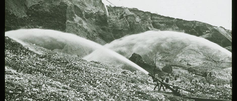
is necessary because the pilings are placed by thawing a hole in the ground
with a steam point and then driving the pile into the thawed muck. Two or
three weeks’ time is desirable to allow the piling to freeze back before
the derrick is erected.The depth to which the pilings are placed and the number of pilings are
determined by several factors:( 1 1 ) . Amount of thaw expected due to summer temperatures (60° to 80°F.), —
or to heat transmitted from the rig engines, mud pits, circulating drilling
mud, heating boilers, etc.( 2 2 ) The depth of the hole to be drilled and the resulting drill pipe —
and casing loads to be handled.
016 | Vol_IIB-0347
EA-I. Gillespie & Coleman: Petroleum Exploration and Drilling
( 3 3 ) The characteristics of the subsoil and the provisions made to —
prevent thawing of the area around the rig foundation. Ordinarily it is
assumed that piling driven in muck will take no load if the muck thaws.
Therefore, the piling must be placed well below the expected thaw depth.
However, in locations where a semicompetent formation is present and ice
lenses are absent, the soil can be assumed to take a load even when thawed.( 4 4 ) It is considered good practice to place the piling at a depth in —
the ground equal to three times the expected thaw depth. This is done to
prevent heaving of the piling due to thawing and refreezing in the active
zone above the permafrost layer. The active zone is normally not deeper
than 2 or 3 ft. Therefore, piling for pipe racks, catwalk, etc., need not
be driven deeper than 6 to 9 ft. in the ground. This applies to foundations
located outside the rig house. Inside the rig house, the thawing may be
deeper, but it can be safely assumed that, while drilling operations are in
progress, the ground once thawed will not freeze back, for the rig house is
kept continuously heated.Based on the above facts and, to some extent, assumptions, since each
new location may present a new problem, piling depths in permafrost have been
determined and proved satisfactory for drilling a well to 7,000 ft. The
following tabulation of depths for piling driven in surface formations known
to be high in water content, ice lenses, and permafrost are worthy of
consideration:( 1 1 ) . Piles under derrick substructures were driven 15 to 18 ft. The —
piling under the derrick corners and under the rotary support were driven
approximately 18 ft. The maximum thawing occurs near the well bore, due to
steam coils around the blowout preventers, and the circulation of warm drilling
and return mud (temperature 85°F.) at completion of the well.
017 | Vol_IIB-0348
EA-I. Gillespie & Coleman: Petroleum Exploration and Drilling
( 2 2 ). Piles under drilling engines and pumps were driven 8 to 10 ft. —
( 3 3 ). No piling was placed under pits, boiler, or water tanks; although —
precautions were taken to prevent thawing in these areas, thawing did occur
resulting in considerable trouble due to inadequate foundations. On future
installations, a piling foundation with the piles driven 8 to 10 ft. (three
to four times thaw depth) will be standard under the boiler, water tanks,
and pits , as well as the equipment already listed. —( 4 4 ). Piling under pipe racks and catwalk to be placed a minimum of 8 ft. —
in the ground. Piling for pipe racks placed 5 ft. in the ground have proved
inadequate because of deep thawing near ruts where heavy equipment was
operated.Experience has shown that in using a piling foundation, the area of
greatest danger is that near the well bore . It was found that 16-in. con–
ductor pipe set at 115 ft. and cemented back to the surface would take no
appreciable load after thawing occurred in the incompetent “muck” formation
in which it was set. Also, the 11 3/4-in . surface string set at 1,028 ft. —
and cemented with 300 sacks of cement required additional support other
than that provided by the 16 -in. casing. The practice has been adopted to —
support the landing base for the surface pipe from piling placed far enough
from the well bore not to be thawed by the warm drilling mud. Piling as
close as 4 ft. to the well bore supported load and apparently remained
frozen. It is definitely known that the temperature in the rathole located
9 ft. from the well bore remained below freezing (approximately 27°F t . at —
15 ft. below ground level) at all times. This was true even though drilling
operations extended over an entire year, starting in June 1947 and ending in
018 | Vol_IIB-0349
EA-I. Gillespie & Coleman: Petroleum Exploration and Drilling
June 1948, with mud circulating temperatures reaching 85°F. It is of
interest to note that in one well the permanently frozen ground extended
to a depth of approximately 950 ft. and that the formation temperature
measured at 6,194 ft. was 154°F.The distribution pattern of piling, including the number, depends upon
the type of substructure, loads to be carried, and the size and strength of
the individual piles. Piling may be allowed to extend several feet above the
ground level and, depending upon the height of the substructure, a very
shallow cellar or no cellar at all may be used. It is desirable to keep the
depth of the cellar to a minimum to eliminate as much as possible the tendency
to thaw the area under the derrick floor. Actually, in arctic operations a
deep cellar is not required because it is necessary to set the casing lancing
head or landing base above ground level. It has been found by experience
that, if the landing base is places below ground level, the water that accumu–
lates in the cellar or around the landing base during the summer months will
freeze, with the danger of ice expansion exerting enough upward force on the
base or bottom flange o r f the landing head to part the surface casing. Provi–
sion can be made for expansion of intermediate or oil strings, but after the
well is completed, the surface casing “freeze-in” makes any provision for
expansion very difficult. It has been found expedient to have no clamps,
flanges, or couplings within the active zone under which water could accumulate
and against which ice could exert a sizable upward force. In view of the
above, cellars used are not deeper than 3 or 4 ft.For deep wells (12,000 ft. or deeper), drilling mud temperatures are
anticipated which will be high enough to require special provisions for cooling
019 | Vol_IIB-0350
EA-I. Gillespie & Coleman: Petroleum Exploration and Drilling
the mud. During the winter months it is a very simple matter to keep the
mud cool because of the low atmospheric temperatures, it being necessary
only to circulate the warm drilling fluids through a cooling pit located
outside of the rig house. Outside temperatures, which are ordinarily below
zero, and the high wind velocities, which are usually present, cool the mud
rapidly. However, during the summer months the atmospheric temperatures
rise as high as 70° or 80°F., and it is not considered possible to keep the
mud temperatures low enough by using only this means of cooling. Since it
is essential that very little thawing be permitted around the piling which
supports the derrick and other drilling equipment, a cooling jacket has been
designed for placement around the conductor pipe so that a cooling fluid may
be circulated. This refrigerating jacket may have to be as long as 300 feet
in order to protect properly both casing and piling from thawing action.Since the reliability of a refrigerating system of this type in oil-well
drilling has not been proved, an additional precaution has been taken to
support the heavy load which can be expected to be placed on the casing
landing base. For deep wells, casing loads may be as high as 400,000 lb s . —
Since some trouble has been experienced on previous wells, due to thawing
around the surface pipe permitting settling of the landing base and surface
casing when the load of the oil string was imposed, a support has been
designed to allow transfer of this load to piling located 15 feet from the
well bore. The landing base is supported by large I-beams which in turn
are supported by 2-in. diameter steel cables. The cables form a suspension
bridge which transfers the load to the piling. To avoid any unnecessary
expense, in case it should not be necessary to run a long string of casing
or in case the cooling system should prove adequate, this casing support is
020 | Vol_IIB-0351
EA-I. Gillespie & Coleman: Petroleum Exploration and Drilling
designed so that it need not be installed until it is definitely known
that it will be required. It is, however, necessary to drive the additional
piling used in supporting the ends of the cables prior to the time that the
derrick is erected. Details of this casing support are now being worked out.Drilling Mud. In an area where atmospheric temperatures range from
80°F. to as low as −65°F., and where ground temperatures range from 22°F.
at a few feet below the surface to more than 150°F. at a depth of 7,000 feet,
a number of difficulties are encountered in handling a water-base drilling
mud. A number of methods have been tried in attempting to determine the
best way of handling drilling mud. Considerable attention has been given
to the use of oil-base muds, but this type of mud is not considered satis–
factory for use in wild-cat drilling, and also the use of this type of mud
inside a closed building presents serious fire hazards. Even without these
two disadvantages, the high cost of an oil-base mud in such a remote area
as northern Alaska would almost forbid its usage. The most commonly used
drilling mud is a bentonite-base mud to which has been added sufficient
barites to give a satisfactory weight.To avoid freezing of the drilling fluid, a number of methods have been
tried to keep the drilling fluid warm. Steel mud pits fitted inside with
steam coils were tried in northern Canada and found to be unsatisfactory,
due to the fact that the drilling mud baked on the outside of the coils and
formed a good insulator. As a result very little heat was transferred from
the steam to the mud. To avoid difficulty, steam coils were built around the
outside of the mud pits. However, using this type of pit during extremely
cold weather without housing proved expensive and not too satisfactory. The
most successful system found for keeping the mud at a temperature above
021 | Vol_IIB-0352
EA-I. Gillespie & Coleman: Petroleum Exploration and Drilling
freezing has been s t o house the mud ditches and pits completely. It has —
been found that the heat supplied by the drilling engines and the pump
engines is, in most instances, adequate to maintain a temperature well
above Creezing inside a closed building.In drilling operations that are expected to continue into the winter
months, the precedure has been adopted of completely housing all equipment,
using either a canvas or a plywood covering. For shallow wells, which can
be drilled in two or three months, it has proved expedient to start these
wells during Jun d e and complete them before the beginning of cold weather, —
usually the latter part of September. In such cases, it is possible to
keep the mud at a proper temperature by adding either warm water or steam
to the pits as required. A small, portable boiler has been found suitable
for this service. For deep wells, additional heat, other than that supplied
by the drilling engines and pump engines, is usually supplied by a boiler
or a forced-Craft oil-burning heater.Although it is necessary to keep the mud temperatures above freezing,
it is also desirable to avoid thawing the frozen ground (which sometimes
extends to a depth of more than 900 ft.) . For this reason it is desirable to —
drill using mud at a temperature only a few degrees above freezing while
drilling the surface hole. The use of a mud that is too warm will excessively
thaw the relatively unconsolidated surface formations, and possibly result in
serious difficulties due to caving or loss of circulation.As drilling progresses, the mud temperatures gradually increase until,
at a depth of 6,000 to 7,000 ft., the temperature of the circulating fluid
will stay between 70° and 85°F. without outside heat. This holds true as
long as drilling is in progress, but the mud will cool rapidly and sometimes
022 | Vol_IIB-0353
EA-I. Gillespie & Coleman: Petroleum Exporation and Drilling
freeze when the rig motors are shut down for overhaul of equipment, fishing
jobs, waiting for cement, etc.Some difficulty has been experienced in disposing of drill cuttings and
waste mud because of freezing. If this material is dumped outside the rig
house, it freezes and stacks up, making removal necessary at regular intervals.
Removal of the cuttings and waste drilling mud by use of a bulldozer has been
found satisfactory. This is particularly true if the drilling rig has been
so laid out that there is a reasonable slope of the ground away from the pit
side of the rig house.Several types of mud pits have been tried, including earthen pits blasted
in the ground with dynamite, steel and wooden pits buried a few feet in the
ground, wooden pits set above ground, and steel pits set above ground. Portable
steel pits, similar to those currently used in drilling in temperate climates,
have been found most satisfactory. These pits are not only better from a
watertight standpoint, but are least damaged when being thawed. The pits
ordinarily are set from one to two feet above ground level to allow air to
circulate below the pits, and the natural tundra covering is left on the
ground surface as an insulation against thawing. By so placing the pits,
thawing of the surface around the pit foundation due to the warm drilling mud
is kept to a minimum. Also, freezing-in of the pits after completion of
drilling operation s is avoided. It is practically impossible to salvage a —
mud pit that has been placed as much as one or two feet below the surface
of the ground.Other than the factors mentioned above, no mud problems have been
encountered that are not ordinarily encountered in warmer climates.
023 | Vol_IIB-0354
EA-I. Gillespie & Coleman: Petroleum Exploration and Drilling
P R r eparations for Running Casing. Due to the extreme temperatures and —
difficulties of transportation, a number of problems occur in handling and
running casing that would not ordinarily be encountered in drilling opera–
tions in warmer climates. It is necessary to move all heavy material from
the main warehouses at Point Barrow to the drilling location during the
winter months when ice is in suitable condition for freighting. The
pipe is unloaded at the location on the ground because it is not usually
possible to anticipate drilling locations far enough in advance to permit
the building of adequate pipe racks. Since the casing is usually unloaded
at the location during February or March, it is always covered with snow at
the time rigging-up operations start at the beginning of the summer thaw.
As soon as pipe racks can be constructed, the casing is moved off the ground
to prevent it from sinking in the mud that forms during July and August. To
conserve heavy timbers, it is sometimes necessary to use empty oil drums to
build casing racks. Unless precautions have been taken in advance to plu s g the —
ends of each joint of casing, the joints are invariably filled with ice and
snow and possibly frozen mud and gravel.Practically all of the wells in this area are spudded in during the month
of June, and for this reason the surface casing is practically always set during
the summer months. Therefore, on these casing jobs, the problems are the same
as would be encountered in operations in warmer climates. The temperature
during the summer months is practically always above freezing.Wells that are started early in the summer are completed during the fall
or winter months when subzero temperatures prevail. In addition to the cold
temperatures and the ice and snow, which is invariably present, operations
during the winter are further hampered by short periods of daylight. There is
024 | Vol_IIB-0355
EA-I. Gillespie & Coleman: Petroleum Exploration and Drilling
not sufficient daylight during the months of November, December , and January —
for outside work without the aid of flood lighting except during two or
three hours in the middle of the day. The problems and hazards involved in
running a long string of casing are numerous under the best of conditions.
When the additional limitations imposed by subzero temperatures and near
darkness are added, it becomes necessary to exercise the greatest care in
making advance preparations for a casing job.Experience has shown that, except during the summer, it is practically
impossible to prepare casing for running into the hole unless the casing
racks are in some manner covered so that they can be heated. In attempting
to work with casing on outside racks, a crew is confronted not only with the
discomforts of severe cold and blowing snow, but also with the fact that the
casing protectors are usually frozen and very difficult to remove from the
pipe. Unless the ends of the casing have been properly plugged and the pluge
have remained in place, each joint of pipe will be full of snow or ice and
will require steaming in order to clear the joint, and unless the racks are
covered, it is not possible to steam the snow and ice from the joint before
it is pulled through the V-door in the derrick cover. Due to limitations of
space, it is not feasible to handle more than two or three joints of casing
in the V-door at a time. Steam hoses can be placed in these joints while
another joint is being made up to go in the hole. However, these joints
extend out on the walk and make it necessary to have the V-door open practically
all the time. Even if canvas is draped across the V-door, enough cold air
circulates into the rig house to make it impossible to keep the temperature
on the rig floor above freezing. Because of these various factors, the
practice of covering the walk and pipe racks with a wood-frame, canvas-cover ed, —
025 | Vol_IIB-0356
EA-I. Gillespie & Coleman: Petroleum Exploration and Drilling
low-roofed house has been adopted. This pipe-rack cover is not required for —
drilling operations and is constructed only after it is definitely known
that casing will be run. The covered area can be conveniently heated,
using the Herman Nelson airplane-type heaters, which are available at
each rig location. In constructing the house over the pipe racks, provi–
sion is made to permit rolling of additional casing from outside racks over
onto the covered racks. It is impractical to cover enough racks for all of
the pipe used in running a long string of casing. After the racks have been
properly covered and heated, the problems involved in running casing are no
different from the usual problems in other areas.Cementing Operations. When working in permafrost, considerable diffi–
culty is experienced in getting cement to set properly, and investigations
have been made by a number of people in an effort to determine the best
method of handling cementing operations. From the experience of the operators
who have been drilling in northern Canada for a number of years, it was learned
that the probability of getting a satisfactory cement job around the conductor
pipe or shallow surface strings of casing was very slight. Owing to the fact
that the formations encountered at shallow depths (100 to 200 ft.) are
usually incompetent and many times contain lenses of ice that may be several
feet thick, it is difficult to get the cement either to set properly or to
make a proper bond with the formation. It has been general practice with
most operators to use ordinary portland cement, although high-early-strength
cements have been tried, as well as calcium chloride as an admixture with
various types of cement. The use of a low-heat-of-hydration cement rather
than a high-heat cement has been advised. Where the formations penetrated
consisted of muck and ice lenses, it has been found inadvisable to heat the
slurry before placement.
026 | Vol_IIB-0357
EA-I. Gillespie & Coleman: Petroleum Exp l oration & Drilling —
Before operations were started in NPR-4 by the U.S. Navy Construction
Battalion personnel, additional information was obtained concerning the
action of cement at below-freezing and near-freezing temperatures by perform–
ing a series of experiments in the laboratories of the Haliburton Oil Well
Cement Company. Tests were made to determine the rate at which warm drilling
mud thawed frozen rock, and to determine the rate at which portland cement
mixed with different percentages of calcium chloride would set at subfreezing
temperatures. Other information was obtained relative to the effect of
different percentages of calcium chloride on the strength, setting time, and
time-of-pumpability of the portland cement slurry. These tests showed that
at subfreezing temperatures, using either two, four, or six per cent of
calcium chloride by weight of cement, and mixing the slurry at a temperature
of approximately 70°F., the slurry set very slowly and in most cases froze
before it reached a final set. The desirability of keeping the cement warm
while it was setting and waiting longer than the usual period before drilling
the plug was definitely demonstrated. It was also found that warm drilling
mud circulated in frozen rock would thaw the rock an appreciable distance in
a matter of a few hours, indicating that the cement slurry in a well would not
be expected to set in contact with frozen formation (provided the formations
were reasonably competent), but would in contact with formation which was
thawed and at a temperature near the temperature of the mud used while
drilling. However, in formations which are not competent or which contain
ice lenses or fractures filled with ice, it is recognized that the drilling
mud circulated will thaw the ice or frozen muck, causing a cavernous condition.
027 | Vol_IIB-0358
EA-I. Gillespie & Coleman: Petroleum Exploration and Drilling
In view of the above information it is desirable to set the surface
string casing in oil wells where incompetent formations are present at depths
of 100 to 150 ft. below the permafrost. Due to the fa x c t that permafrost in —
NPR-4 extends to a depth of more than 900 ft. at most locations, it has been
necessary to set surface casing from 1,000 to 1,100 ft. in most wells. This
does not strictly apply to locations in the southern part of this Reserve
where the formations at shallow depths are better compacted. The greatest
difficulty is encountered in setting 50- to 100-ft. strings of conductor
pipe and in setting pipe in shallow holes where it is considered too expensive
to set a long s g t ring of surface casing. In some cases, a considerable amount —
of trouble is encountered, due to mud breaking out around the outside of the
conductor pipe before the hole can be drilled to the desired depth for setting
surface pipe. As a general practice for cementing conductor pipe, it has been
found expedient to use high-early-strength cement and warm the mixing water
to a temperature of 90° to 100°F. The warm mixing water gives the cement a
chance to start its hydration process before the slurry temperature is reduced
to freezing by the formation, and in some cases a satisfactory shutoff is
obtained. In any event, by cementing the conductor string in preference to
setting the pipe without cementing, the volume of mud that leaks around the
conductor is kept to a minimum and usually does not present a too serious
hindrance to drilling operations.The procedure followed in setting the surface string of casing has been
to use portland cement and heat the mixing water to a temperature between
100° and 130°F., using sufficient cement to circulate into the cellar. After
the cement has had adequate time to take an initial set (at least 12 hours is
allowed), the pressure is released from the casing string, and the drill pipe
028 | Vol_IIB-0359
EA-I. Gillespie & Coleman: Petroleum Exploration and Drilling
is run in the hole to near the top of the cement plug. This is done to permit
injection of steam with the idea in mind of heating the drilling mud inside
the casing. By injecting enough steam into the drilling mud to keep it at a
temperature just below boiling for a period of approximately two days, it has
been found that ordinarily cement will set and harden so that a satisfactory
cement job is obtained. After the drill pipe is pulled out of the hole, the
mud will remain at a temperature well above 100°F. for as long as two days.
It is recommended that at least 72 hours be allowed for the cement to harden
before drilling the plug.Although temperatures below freezing are encountered at depths of 900 to
950 feet, the temperature gradient approaches normal for other areas from that
depth to the total depths which have been drilled in NPR-4. At one well the
bottom of the permafrost was determined to be approximately 950 ft., and at
6,194 ft. the formation temperature was 154°F. In view of this, it is possible
to use normal cementing procedures in cementing intermediate and oil strings
of casing. However, since the mixing water is ordinarily obtained from lakes
which are either covered with several feet of ice, or in which, in any event,
the water is at a temperature near freezing, it is sometimes advisable to
warm the mixing water with steam, even when cementing at depths of 4,000 to
5,000 feet. This, of course, depends largely upon the quantity and type
of cement to be used, and the expected placement time. In cases where port–
land cement is used, it is good practice to use mixing water at a low tempera–
ture in order to have adequate time to place the cement. However, if a slow–
setting oil well cement is used for a relatively short string of casing, the
mixing water should be warmed to a temperature of at least 70°F. in order to
get the cement to reach a final set without too long a shutdown period.
029 | Vol_IIB-0360
EA-I. Gillespie & Coleman: Petroleum Exploration and Drilling
Since practically all drilling operations in NPR-4 are at isolated
locations, which are accessible to heavy equipment only during the winter
months, it is necessary to equip each drilling rig with a cementing unit.
Because cementing operations may be required at temperatures as low as −40°
to −50°F., it is necessary to house the cementing units and make adequate
provision to prevent freezing of the water lines and cement discharge hoses.
The cementing equipment itself is customarily house s d in the rig house which —
covers the mud pumps and other drilling equipment. However, it has been
found advisable to place the mixing hopper in a special lean-to canvas–
covered house separated from the drilling equipment and cementing pumps.
This is done to afford additional room for handling cement, which is not
ordinarily available inside the regular rig house, and also to prevent the
cement dust from getting into machinery and damaging the moving parts. Due
to the numerous difficulties that can be encountered in any cementing operation,
and particularly t i n a cementing operation conducted in subzero temperatures, —
complete preparations have been found necessary well in advance of any expected
cementing job. All machinery is checked and put in the best possible condition,
ample provisions are made for heating all machinery, and suitable r e amps are —
built for handling the cement.The cement used at a drilling location in this area is of necessity
purchased many months prior to its usage and receives rather severe treatment
due to the numerous times it must be handled in getting it from the cement
plant to the locations. In many cases the cement is stored either in a ware–
house at Point Barrow or at some remote location for two years or longer.
For this reason, there has been great difficult in keeping cement packed
in either cloth or waterproof paper bags, or a combination of both, in suitable
030 | Vol_IIB-0361
EA-I. Gillespie & Coleman: Petroleum Exploration and Drilling
condition for use in oil - well cementing. An effort was made to obtain cement —
in commercial metal cement containers. However, such cement containers have
not been available, and it has been found expedient to pack cement in metal
powder cans equipped with a quick-opening waterproof top. These cans hold
approximately three sacks of cement, and the cement plus the can gives a
total weight of 320 pounds. These have been found to be a suitable size for
rolling to the cement hopper, and they can be dumped by two men without undue
difficulty. Although to date cement has not been stored for any appreciable
time in this type of can, it is believed that, since they were satisfactory for
the storage of gunpowder, they will prove satisfactory for the storage of
cement.Bart W. Gillespie & J. Ralph Coleman
Geological and Geophysical Operations
Unpaginated | Vol_IIB-0362
EA-I. (Walter English)
GEOLOGICAL AND GEOPHYSICAL OPERATIONS
CONTENTS
Page Geological Methods 1 Geophysical Methods 5
001 | Vol_IIB-0363
EA-I. (Walter English) ✓
GEOLOGICAL AND GEOPHYSICAL OPERATIONS
Although closely allied from a scientific point of view, geological
and geophysical field work require quite different methods and different
types of support. Modifications in methods necessary because of arctic
conditions are, therefore, discussed separately for each. The following
descriptions are to be taken as applying particularly to exploration for
oil in Naval Petroleum Reserve No. 4, Alaska.GEOLOGICAL METHODS
Geological field investigations consist of examining the rocks which
may be sampled at or near the surface, selecting a system of classification
into groups suited to the particular region, and mapping the areal extent
and structural attitude of each group. The number of groups and the detail
in which they are mapped are controlled by the purpose of the investigation
and the funds and time available. Considerable information may be obtained
by stereoscopic viewing of aerial photographs. Viewing the ground from an
airplane or by means of field glasses from a neighboring hilltop will fill
in many of the details. However, the most reliable and basic information
must be acquired by direct examination on the ground; the geologist visits
the outcrops, determines the character and attitude of the rocks, and takes
002 | Vol_IIB-0364
EA-I. English: Geological and Geophysical Operations
takes samples for laboratory study. It is this requirement of examination ✓
on the ground that makes geological mapping in the a A rctic a rather arduous ✓
occupation.The rocks themselves and their structural attitudes are, to all intents,
of the same character in the a A rctic as in more temperate zones. It might be ✓
expected that sedimentary rocks would present characteristic arctic types,
but apparently the geological processes of the a A rctic are not sufficiently ✓
different from elsewhere to make any modifications in the methods of study
necessary for that reason. The igneous and metamorphic rocks are, likewise,
of the same character as met with elsewhere. The presence of ice as a rock
and as a rock constituent in frozen ground presents problems of study that
are somewhat different from the problems of glacial geology of high altitudes
of the temperate zone. The physiography of the arctic coastal plane plain is a ✓
novel and fascinating problem to the newcomer. The origin of the thousands
of large and small oval lakes, all with their major axes oriented in the
same direction, has not as yet been fully explained.Direct examination of outcrops is dependent for its success upon the
presence of sufficient outcrops, and on the ability of the geologist to
locate and visit them. In the higher, more rugged parts of the Brooks Range,
the steeper slopes remain partially bare of snow in winter. It would be
possible to carry on some field work here, but it would not be advantageous
due to rigorous climate and the small amount of daylight available. In
lower hills with less rugged topography, and particularly where the underlying
rocks are sedimentary, the surface is completely covered in the winter. For
T t his reason field work by geologists must be confined to the summer months. ✓
003 | Vol_IIB-0365
EA-I. English: Geological and Geophysical Operations
In general, outcrops are less abundant in the Arctic under similar
conditions of terrain and rock type than they are farther south. The arctic
moss covers quite effectively a very large proportion of the total area.
Variations in soil color and vegetation are not usable for interpretation
to any great extent in the Arctic. Moss will cling to fairly steep slopes
and not even the smallest chip of rock will be present on the surface. While
this is the general condition, thin layers of hard sandstone or limestone will
often become evident at the surface by a scattering of rubble fragments along
the top of the moss over the position of the bed. These have been designated
rubble traces by geologists mapping them. Sometimes such rubble traces can
be followed on the ground for long distances without coming to any outcrop
of the underlying material.Though hidden from direct view, the underlying rocks may be only a
matter of a foot or so under much of the surface. Thus, samples can be
obtained by a small amount of digging in most places. Even though chemical
weathering is at a minimum, it is still hard to dig deep enough with a pick
to get a satisfactory sample because of the g f rozen condition of the ground. ✓
It has been suggested that, where the character of the transportation support
of a party is capable of handling the extra weight, it would be desirable
to have some sort of miniature rotary drill capable of taking cores in fairly
hard rock to a depth of about ten feet.The task of locating outcrops is much facilitated by a study of vertical
aerial photographs of the area. For this reason, it is highly desirable that
the geologist be furnished photographs giving full vertical coverage with
stereo overlap before field operations are commenced, so that routes of
travel may be planned intelligently and promising areas selected for camps.
004 | Vol_IIB-0366
EA-I. English: Geological and Geophysical
The photographs will indicate where outcrops are likely to be found, guide
the geologist to the location by the best route, and, when the examination
is complete, will place the locality on his aerial map.While much of the value of pictures may be obtained by nonstereo
inspection, it is the writer’s personal feeling that the additional informa–
tion coming from the use of a stereoscope makes it mandatory for the geologist
to have some sort of stereoscope in the field with him. Various designs of
small bulk are available, the smallest being the single prism eyepiece used
by the Geological Survey. Although this eyepiece is not considered desirable
as an office instrument, it [ ?] certainly is small enough that nobody should
complain of its bulk in the field.Pictures are of much value for further office study and many of the beds
found at single localities in the field may be traced for miles on pictures
examined later in the office. There should also be some parallax reading
instrument available so that measurements may be made on the pictures, and
amount of dip of beds computed. Very often dips read on bed traces observable
in pictures from a ridge crest across a gully to the next ridge crest give
better values for strike and dip than those taken in the field by readings
on small outcrops.The planning of a geological investigation of a new region will probably
include the following steps or stages. First, the region should be photographed
and the photographs examined by the office geologist. Then, a few airplane
trips should be taken over the territory to get an idea of logistic possibilities,
in relation to the location of the most interesting areas. Next, it will probably
be desirable to traverse the major streams by boat. In this connection, it may
be remarked that a navigable stream is one that will float a canoe and is
005 | Vol_IIB-0367
EA-I. English: Geological and Geophysical
deep enough over the rapids for the canoe to be dragged across. Next, “weasel”
parties should visit areas remote from navigable streams. Finally, spot
landings from an airplane should be made to visit isolated outcrops. For
this last-mentioned task a helicopter would be ideal if they are considered
safe for the weather conditions which might be expected.GEOPHYSICAL METHODS
Geophysical studies for oil exploration are frequently carried on with
magnetometer, gravimeter, and seismograph. With each of these we have had
experience in the Arctic. Earth resistivity and earth electrical currents
are studied on mining projects. Resistivity has been used for frozen ground
studies but not for geology in the Arctic.The magnetometer has recently taken to the air, the instrument used being
an adaptation of an instrument developed during World War II for locating
submarines. One of the first large area magnetometer jobs was that of the
Naval Petroleum Reserve No. 4. Electrical storms that affect the magnetometer
readings are more prevalent in the Arctic than elsewhere, but otherwise there
are no technical difficulties except those of aerial navigation and carrying
ground location. Turbulent atmosphere reduces the accuracy of the magnetic
observations because of sudden accelerations given the instruments. Since
electrical storms and wind storms are less prevalent in the summer and it
is easier to spot ground location, then, surveys of this type are best carried
out in the summertime.Conventional gravimeter work requires a ground party, and most of the field
work is that of surveying. A stadia traverse is sufficient for a plan location ✓
but a continuous line of levels, accurate to the foot, is necessary to give
006 | Vol_IIB-0368
EA-I. English: Geological and Geophysical
correction factors to be used in interpreting the gravimeter readings. The
gravimeter readings themselves are unaffected by climate and do not require
any preliminary preparation of the ground at a point where a reading is to
be taken. Seasonal limitations are entirely those of logistics and sufficient
light to carry on surveying operations.A rather novel type of gravimeter work was carried out in the Navel
Reserve to get data on regional gravity variations, in addition to work of
the conventional type. The regional work was done by moving the gravimeter
from place to place in an airplane, landings being made with skis on frozen
lakes during the winter and with pontoons in the summer. Elevation control
was obtained from a base aneroid barometer and one carried in the field with
the gravimeter. The latitude, which is also necessary for interpreting the
readings was obtained with sufficient accuracy from available maps. The data,
when compiled, gave a consistent pattern of broad gravitational variations,
so the work was considered successful.It has been suggested that the effect of frozen ground must be considered
in interpreting detailed gravity maps. If the frozen layer, which may be up
to 900 feet thick, contains erratic lenses of ice, the difference in density
between the ice and adjacent sediments would produce gravity anomalies. These
might be mistaken for anomalies in more deeply buried rocks. Information
obtained from shot holes drilled for seismograph work indicates that in the
first hundred feet of depth there are wide variations in ice content of the
individual beds. Lenses of nearly pure ice are encountered at all depths to
which shot holes have been drilled. Running sands and gravels are also en–
countered, and these are interpreted as “dry frost,” a term invented by the
placer gold miners to describe beds of sand and gravel that are below the
007 | Vol_IIB-0369
EA-I. English: Geological and Geophysical
freezing temperature of water but do not contain any ice in the spaces
between the rock fragments. Both dry frost and ice lenses have very low
densities compared to the other components of the geologic column. Closely
spaced gravity readings, taken across the steep bluffs that bound some of
the lakes, indicates a density of the surface beds as low as 1.20. Such
a low density can be accounted for only on the assumption that a good propor–
tion of such beds is ice.A large amount of seismograph work has been done on the arctic coastal
plain. The greater part of this has been by the reflection method, but
refractions have also been used. In general, the reflection seismographs
have excellent quality reflections. Except in areas of very low dip, this
method is believed to yield reliable indications of the underlying structure.
For areas of very low dips the possibility of error must be considered due
to the peculiar characteristics of the frozen ground layer, which extends
from the surface down to depths of several hundred feet. Temperature surveys
in wells in this area indicate that the temperature of 32°F. is reached at
depths of 700 to 900 ft. Very little is known at present of the wave trans–
mission characteristics of frozen ground, and of the variations that may take
place from one locality to another. There is some indication given by a
study of the reflections that there may be variations in the quality of the
frozen ground, and also that its thickness may vary in relation to lakes,
past and present. Such variations, insofar as they are proved to exist, might
lead th the mapping of pseudo structures.Refraction shooting presents no unusual problems in the Arctic. The
velocity of wave transmission in the frozen ground is of the order of 8,500
to 11,000 ft. /sec. This is considerably greater than that of the immediately
008 | Vol_IIB-0370
EA-I. English: Geological and Geophysical
underlying beds over most of the arctic slope. This results in first arrivals
out to distances of 15,000 ft. from the shot point, and sometimes 20,000 ft.,
having wave paths through the frozen zone. Refraction profiles had, therefore,
just as well begin at a distance of 15,000 ft. from the shot point rather than
extending the spread back to the shot point.Logistic support for seismograph crews is a much more formidable tack
than for other types of geophysical or geological parties. The necessity of
carrying along a shot-hole drill, which with its mounting weighs several tons,
sets the mobility limit for the party. With such a heavy drill unavoidable,
the other equipment may just as well be assembled in units of several tons
weight, and this is done. The whole caravan will consist of ten to fourteen
sled-mounted trailer units (wanigans), with tractors to haul them, and “weasels”
for taking men back and forth during field work.The field camp of a seismograph crew must be moved every few days, and
the moving of the caravan of trailers is a difficult task in the late summer
when the ground may be thawed to a depth of one or two feet. Transportation
is at its best in the winter and before the thaw in early spring. For this
reason caches of dynamite, fuel, food, and other supplies are put out by
tractor train during the winter along the route to be followed later by the
shooting crew. In this way the total tonnage to be moved from camp to camp
is reduced. From early spring to the time of thaw is the most efficient time
for the shooting crew to do its work.Walter English
Seismograph and Gravity Meter Operations
Unpaginated | Vol_IIB-0371
EA-I. (John A. Legge, Jr.)
SEISMOGRAPH AND GRAVITY METER OPERATIONS
CONTENTS
Page History 1 General 2 Seismograph Operations 5 Gravity Meter Operations 9
Unpaginated | Vol_IIB-0372
EA-I. Legge, Jr.: Seismograph and Gravity Meter Operations
LIST OF FIGURES
Page Fig. 1 Geophysical drill wanigan 6-a Fig. 2 Seismic recording wanigan on weasel frame 8-a Fig. 3 Seismograph cable laying weasel showing cable drums 8-b Fig. 4 General view of seismograph mobile camp 11-a
001 | Vol_IIB-0373
EA-I. John A. Legge, Jr.
SEISMOGRAPH AND GRAVITY METER OPERATIONS
History . Seismograph and gravity meter operations were first under–
taken in the Alaskan Arctic, in 1945, under the sponsorship of the United
States Navy as part of a program to determine the extent of the oil reserves
of Naval Petroleum Reserve No. 4. At this time operation of Naval Petroleum
Reserve No. 4 was carried out by U.S. Naval Construction Detachment No. 1058.
A small group of officers and men was assigned the duty of making a gravity
meter survey of the Cape Simpson area inasmuch as the large seeps in this
district were the subject of considerable speculation as to their origin.
Seismograph operations were carried out by a group of four civilian tech–
nicians of the United Geophysical Company assisted by a group of naval
personnel.The original work at Cape Simpson was aimed at testing the applicability
of gravity meter and seismograph exploration to arctic conditions, and the
development of operational techniques. There was little doubt that gravity
data of comparable accuracy to that obtainable in other parts of the world
could be achieved.Since no great technical difficulties were encountered with the seismo–
graph, the initial work was pointed toward the solution of the complex
operational and equipment problems. In view of the fact that these operation
002 | Vol_IIB-0374
EA-I. Legge: Seismograph and Gravity Meter
were carried on entirely during the summer season, little factual informa–
tion was obtained regarding winter operations.Early in 1946, the operation of Naval Petroleum Reserve was placed
in the hands of civilian contractors who continued and expanded the work
begun the previous year. In the years following, gravity meter and seismo–
graph work was undertaken on an increased scope. Techniques were developed
permitting the operation of geophysical parties as early as March. Equip–
ment, particularly in respect to portable camps, was developed, which
increased the mobility, efficiency, and comfort of the field parties.General. The purpose of a geophysical survey, whether it be gravimetric
or seismic, is to obtain physical data that can be interpreted in terms of
existing geological formations and structures. In order to accomplish these
ends in an economic and efficient manner, the organization and planning
previous to the actual operation must be thorough and complete. The Arctic
is different from other regions of the world in this respect only in degree.The great variance between winter and summer seasons is matched by no
other region. The winter season with its high winds, thick ice, and complete
snow cover is the period of greatest mobility but of the least physical
comfort. It is during the latter part of the winter (February to May) that
fuel and all equipment too heavy to be carried by small aircraft must be put
in the field for the season’s work, for once the thaw begins with its deterio–
ration of lake, river, and sea ice, all long-distance hauling of heavy
equipment and supplies must stop. Field parties are then dependent upon
small aircraft for logistical support.
003 | Vol_IIB-0375
EA-I. Legge: Seismograph and Gravity Meter
Fuel for heating and operation of motorized equipment is of course
the life blood of an operation in the Arctic. The estimation of fuel
consumption must be carefully considered. Fuel must be cached along the
route of the party in such a manner that a minimum of adjustment is neces–
sary during the thaw period.The mechanized equipment requirements of both gravity meter and
seismograph operations are similar, differing somewhat in quantity of units.
The mechanization fulfills two prime purposes: camp movement, and transpor–
tation of men and equipment in the field. The Caterpillar D-8 tractor with
dozer blade and winch has been the principal prime mover, serving not only ✓
for movement of camps and supplies but for movement of heavy seismograph
equipment in the field. For transportation of personnel in the field,
scouting, and other light-duty operations, the “weasel,” U.S. Army Ordnance
(M29C), has been used almost exclusively.Several types of mobile housing have been tried with varying degrees
of success. The latest and most satisfactory type of housing has been
found in the 16- by 24-foot Jamesway Hut mounted on pipe runners. This
type of wanigan serves admirably for sleeping, office, galley, and mess;
however, for units like a shop, utility, or storage, bolted-frame con–
struction must be used because of their heavy-duty service. All wanigans
are mounted on pipe runners, which allow a free clearance of 24 inches.
Though this much clearance is not essential for winter operation, it is
imperative for summer operation when units must be pulled through the mud
and slush of the thaw.
004 | Vol_IIB-0376
EA-I. Legge: Seismograph and Gravity Meter
As with any modern arctic operation, air support is an important phase.
Once in the field, parties are dependent upon air support for supplies, mail,
and transportation of personnel to and from a main base when necessary.
During the winter season, small ski-equipped aircraft may be used. It is
also possible at this season to construct excellent runways on frozen lakes
by merely removing the snow cover. Planes as big as a DC-3 have been safely
landed on such landing strips. Between the period of complete freeze - up and ✓
complete thaw, an interim of approximately three weeks occurs in which there
is not sufficient ice for ski landings nor sufficient water for float landings.
p P reparation for this period must be such that the field party will be self- ✓
sufficient during this time. In the fall a similar condition exists when
neither skis nor floats may be used. This period is considerably longer than
the spring break-up as it takes longer to form safe ice for ski landings than
it does to form sufficient water during the spring. Extensive use of the
helicopter in the Arctic is not yet a reality but when such aircraft are
available the problem of air support during thaw and freeze-up will be
essentially eliminated.Radio contact with the main base of supply, at least on a daily basis,
is extremely important. It is through this means of communication that the
party may transmit all its routin s g business and reports of emergencies. ✓
Unfortunately, atnospheric conditions in the Arctic are such that radio
contact cannot be maintained as much as desired. Periods from a few hours
to several days are encountered during which communication with a mobile
field party is virtually impossible.
005 | Vol_IIB-0377
EA-I. Legge: Seimograph and Gravity Meter
Clothing requirements of geophysical units very considerably depending
upon the work in which the individual is engaged. Those engaged in inside
work such as cooks, computers, and to some extent mechanics need clothing
to protect them from exposure to the cold for only brief intervals. Those
working outside, where quarters are available for periodically warming up,
must have clothing somewhat warmer but not as heavy as individuals who are
exposed to the weather for periods of several hours, e.g., surveyors.
Clothing must warm but not bulky enough to hinder the operation of instru–
ments and equipment. Native mukluks have gained universal favor amont geo–
physical personnel. Alpaca or down parkas and pants have proved adequate
for most geophysical personnel, though in intensely cold or windy weather,
surveyors usually require fur parkas.SEISMOGRAPH OPERATIONS
Seismograph operations may be broken down into five basic units:
surveying, drilling, shooting, recording, and computing. Though each of
these operations is distinct within itself, their interdependency is such
that the entire unit must work as a team. The strength of each division must
be so planned that no particular unit is overworked, to maintain a uniform
flow of data.Seismic surveying is basically no different in the Arctic than in other
remote regions. Surveying instruments, in order to function properly, must
be thoroughly cl d e aned and freed of all oil and grease that will stiffen when ✓
cold. Graphite or other lubricants not affected by cold must be substituted.
Instruments once exposed to the cold should be kept outside to eliminate
alternate heating and chilling, which cannot only be a source of error but
will tend to cause internal fogging of the lenses.
006 | Vol_IIB-0378
EA-I. Legge: Seismograph and Gravity Meter
The surveying parties rely upon one or preferably two “weasels” for
transportation, one of which is supplied with facilities for carrying
instruments, tripods, stakes, and chains. The principal hindrance to
arctic surveying occurs during the frequent periods of low visibility,
whether it is blowin d g snow or fog. The time - worn “make hay while the sun ✓
shines” is in no place more applicable than in respect to arctic surveying.Two types of shot-hole drills have been used on Naval Petroleum Reserve
No. 4 for drilling: the Failing 314 C and the Mayhew 1000. These units have
been mounted on pipe runner sleds similar to those used for camp wanigans.
A bolted-frame wanigan protects the drill crew and equipment from the weather
(see Fig.1). This unit is towed from location to location by A a D-8 tractor, ✓
T t he driller usually serving in the dual capacity of driller and tractor ✓
operator.During cold weather when drilling machinery is shut down between shift s, ✓
pumps and lines must be drained of drilling mud to prevent their being damaged
by freezing. Because of the fire hazard involved, it has been found inadvisable
to leave heaters with drilling equipment unattended.Water for the drilling operation has been supplied by water wanigans,
which consist of one or two 5- by 5- by 7-foot steel pontoons mounted on a
“go-devil” sled and covered with a frame wanigan. A fuel oil heater is main–
tained in the wanigan to prevent freezing of the water during cold weather.
The fire hazard cannot be avoided in these units and several have been lost
from fires caused by faulty stoves or stove operation. Each of these water
units contains a small centrifugal pump and the tanks are filled by pumping
water from beneath the ice of lakes nearby the drilling operation.
006a | Vol_IIB-0379
Fig. 1
007 | Vol_IIB-0380
EA-I. Legge: Seismograph and Gravity Meter
Since 1,000 to 2,000 gallons of water are required per day for the
drilling operation, an adequate water supply must be located near the site
of the operation. Along the coastal areas where most of the lakes are quite
shallow, it is frequently difficult to locate lakes that have not frozen to
the bottom by late winter or spring. Local Eskimos are often cognizant of
the deeper lakes and much time has been saved by making use of their know–
ledge. In the plateau belt of the Alaska arctic slope, most of the lakes
have a characteristic deep center, which may be as much as forty feet in
depth, thus insuring an adequate water supply at any time. During the summer
season, water is abundant in this area and presents no supply problem.In the Alaska arctic coastal plain, where most of the surface formations
are unconsolidated sediments of relatively recent geologic age : , little diffi- ✓ comma not semicolon
culty is encountered drilling the 60-foot holes usually required for seismograph
work. With a 4½-inch, hard-faced, three-wing drag bit, the drilling of such a
hole can be accomplished in 30 to 60 minutes. The freezing time of shot holes
varies considerably but as a general rule a shot hole cannot be relied upon to
stay open more than three hours if the drilling fluid is not removed. During
the winter when there is no danger of surface water flowing back into the hole,
water may be removed either by bailing or by blowing the hole dry with five to
ten pounds of dynamite. Dry holes remain in excellent condition for several
weeks if precautionary measures are taken to prevent their being filled by
blowing snow. During the summer season when surface water is abundant, it is
usually necessary to time the drilling operation so that the interval between
the drilling and subsequent shooting and recording is small enough to prevent
freezing of the shot holes.
008 | Vol_IIB-0381
EA-I. Legge: Seismograph and Gravity Meter
Water tamping of charges is necessary in order to obtain sufficient
ground energy. Water for this purpose has been supplied to the shooting
crew by units identical to those used by the drilling crew. Shooting depth,
or the depth at which a shot must be fired to obtain the best energy return,
is usually between 50 and 60 feet, though there are local areas which require
a somewhat deeper or shallower placement of charges. Ten to twenty pounds
of standard seismograph dynamite is usually sufficient to give a satisfactory
energy return to reflected energy. Refraction shooting, on the other hand,
requires charges of much greater magnitude to deliver energy over the long
offsets. Charges of 500 to 1,000 lb. are common for offsets as great as
40,000 ft.Elec t ronic seismograph instruments require very little special adaptation ✓
to arctic work (see Fig. 2 0 ). Electromagnetically damped geophones are ✓
necessary to eliminate the viscosity problem present with oil-damped geophones
at low temperatures. Because of the close manufacturing tolerances of electric
magnetically damped geophones, they must be tested in a cold chamber and
altered, if necessary, to insure their operation in subzero temperatures. All
cable insulation should be cold-tested to insure its remaining flexible at
the temperatures encountered in the arctic winter (see Fig. 3).Amplifiers, recording oscillographs, and developing equipment must be
artificially heated during [ ?] operating hours. This is essential to prevent ✓
condensers and resistors from changing their characteristics, to prevent
fogging of the optical system from the operator’s breath, and to prevent
freezing of the paper or film developing solutions.
008a | Vol_IIB-0382
Fig. 2
008b | Vol_IIB-0383
Fig. 3
009 | Vol_IIB-0384
EA-I. Legge: Seismograph and Gravity Meter
For best energy reception, geophones must be placed directly on the
frozen ground. During the summer this can be accomplished by digging through
the thawed tundra. In late summer the thaw seldom penetrates more than
eighteen inches in tundra-covered areas.It has been the general practice to compute and plot the results in
the field office. This procedure is in many respects most advantageous as
it allows the seismologist an opportunity to keep a running check on the work
and make changes in field procedure as conditions dictate . h H owever, if special–
ized interpretation techniques are desired or a consolidation of the work of
several parties, it is advisable to establish a central office for handling
seismograph data from one or more parties.GRAVITY METER OPERATIONS
The equipment requirements of a gravity meter party in the Arctic are
less than those of a seismograph operation. Prime moving equipment is needed
only for the movement of camps and supplies as the field work can be carried
out completely with light-duty equipment.Gravity meter surveying consists of two field procedures: surveying and
gravity meter observation. Surveying for a gravity party in the Arctic, as
in other remote regions where no previous vertical or horizontal control has
been established, is more comple s x than in areas where adequate bench marks ✓
are available.In order to prevent the large accumulation of errors in horizontal control,
a triangulation net of third-order accuracy is advisable. Within and adjoining
such a net, locations of individual stations may be made by resection with
plans table and alidade. The local variation of magnetic declination in the
010 | Vol_IIB-0385
EA-I. Legge: Seismograph and Gravity Meter
Arctic is such that no reliance can be placed in the magnetic needle for sur–
veying purposes.In gravity surveys of a detail nature, elevation control should be such
that station elevations are to an accuracy of approximately 0.5 feet. Wye or
dumpy levels have been used exclusively for leveling of detail surveys in the
Arctic.Approximately four surveying crews, one triangulation, one plane table,
and two level, are necessary in the Arctic to keep one gravity meter with
sufficient stations. In areas of hilly terrain it is usually necessary to
increase the plans table and level personnel, as their production will be
limited appreciably.Gravity meters for use in the Arctic must be previously cold-tested for
excessive drift. Even a mong meters of the came make, a variation in drift has
been found which is accentuated when they are operated in subzero temperatures.Transportation is of necessity much slower than that in areas of developed
roads and highways. For that reason gravity base stations must be established
at more frequent intervals than is usually necessary. The tying and establishment
of gravity bases is a tedious and expensive operation due to the high cost per
mile of operation of the “weasel” (M29C), and for that reason it has been
found not only economical but more accurate to establish bases during the
winter by a small ski-equipped aircraft.Where detailed gravity information is not desired yet a regional gravity
picture of less degree of accuracy is advisable, the Arctic is almost ideally
suited for an air-borne gravity meter operation. In 1947, 13,000 square miles
were surveyed by means of such an operation on Naval Petroleum Reserve No. 4.
During the winter or spring the complete snow cover offers almost unlimited
landing facilities for a small ski-equipped aircraft while during the summer
011 | Vol_IIB-0386
EA-I. Legge: Seismograph and Gravity Meter
the abundant lakes offer landings for pontoon-equipped aircraft. Elevation
control may be carried by surveying altimeters. Though no statistical
analysis of the results of the above survey was made, the accuracy of
repeated stations indicated that a high percentage of the stations were
within an error of ten feet.The problems presented to gravity and seismograph operations in the
Arctic are not ones involving techniques and measurements as much as of
logistics during the widely differing summer and winter seasons (see Fig. 4).
The necessity for sound planning, equipping, and timing of a geophysical
operation in the Arctic cannot be underestimated. Mistakes are costly in
time, money and under certain circumstances even lives.John A. Legge, Jr.
011a | Vol_IIB-0387
Fig. 4
Deep Well Logging Methods in Arctic Alaska
Unpaginated | Vol_IIB-0388
EA-I. (Stewart E. Folk) ✓
DEEP WELL LOGGING METHODS IN ARCTIC ALASKA
CONTENTS
Page Lithological 1 Mineralogical 2 Paleontological 3 Fluorescence 4 Gas Content of Drilling Fluid 4 Electrical Resistivity and Potential 4 Temperature 7 Rate of Penetration 8 Seismic Velocity 9
001 | Vol_IIB-0389
EA-I. (Stewart H. Folk)
DEEP WELL LOGGING METHODS IN ARCTIC ALASKA
Experience of the writer in the Arctic has been entirely in northern
Alaska, and the following discussion accordingly is restricted to operations
in that area.Well logging methods employed in northern Alaska fall into two categories:
( 1 ) studies and analyses of samples brought to the surface which include:
lithological, mineralogical, paleontological, fluorescence, and gas content
of drilling fluid; and ( 2 ) measurement of properties of formations in situ
as: electrical resistivity and potential, temperature, rate of penetration,
and seismic velocity.All of the above-mentioned methods originated in other areas and have
been applied to subsurface exploration in northern Alaska with little or no
change in technique. A brief outline of each, with comments as to results
obtained, is given in this article.Lithological. Samples of the strata penetrated by a well are taken at
intervals of 5 or 10 feet as drilling progresses, and are examined micro–
scopically to ascertain the presence of any petroleum and determine the
character and thickness of each lithologic zone or formation. Samples of
some types of rocks are treated chemically to obtain additional information
concerning their composition. When cores are obtained, porosity and permea–
bility, fluid content, and specific gravity analyses are made.
002 | Vol_IIB-0390
EA-I. Folk: Deep Well Logging
Such lithological studies have been successful for the most part in
their primary purpose, the recognition of oil-and/or gas-bearing zones
encountered in the wells. A few oil and gas zones (of no commercial impor–
tance, however,) were not detected by lithological examination, but
subsequently were found by other means.In some parts of the world lithological logs are quite useful in
tracing different formations from one well to another and to the outcrop area,
thereby delineating geological structure and locating new oil fields. Unfor–
tunately their utility in this respect is limited in northern Alaska, because
in the greater part of the sedimentary section there are few distinctive
zones that extend over a wide area. Furthermore, lithological studies of
the Tertiary section, which probably amounts to as much as 8,000 feet in some
[ ?] places, are made difficult by the lack of induration of the component strata; ✓
particles disaggregate rapidly, making it almost impossible to obtain repre–
sentative samples unless cores are taken. Also the Tertiary formations cave
or slough badly and contaminate samples from underlying strata. Most of the
pre-Tertiary formations (Cretaceous and older), however. are firmly indurated
and accordingly afford good samples for f logging. ✓Mineralogical . Component minerals of sandstone formations are identified
and their relative abundance determined. To facilitate this, samples of the
formations first are disaggregated and the minerals separated on the basis of
specific gravity by flotation in heavy liquids. In some regions certain heavy
minerals, such as garnet, zircon, and tourmaline, are diagnostic of particular
formations. This method of logging has not produced any notable results in
northern Alaska as yet, but continued work may contribute data of more value
in the future.
003 | Vol_IIB-0391
EA-I. Folk: Deep Well Logging
Paleontological . Samples of all strata penetrated in drilling are
examined for the presence of fossils that may establish the identity of
the zone in which they occur and thus make it possible to correlate or
trace that particular zone from place to place. Most of the paleontological
work is concerned with microfossils. principally For e a minifera, so small that ✓
they can be identified only under a microscope.Relatively large and well-preserved microfossils are common in the upper
Tertiary and Quaternary sediments, but these strata attain a maximum thickness
of only a few hundred feet and consequently are of no importance from the
standpoint of petroleum production. Microfossils in the lower Tertiary and
Cretaceous formations, which constitute most of the stratigraphic section
penetrated in drilling to date, are not abundant, and the species represented
are for the most part quite small, arenaceous in composition, and in a poor
state of preservation, and consequently are difficult to identify. The
Tertiary sediments disaggregate readily, facilitating the separation of the
microfossils from the samples but introducing the problem of contamination
of samples by caving or sloughing of overlying strata in the hole. The
Gretaceous and older formations are firmly indurated, and consequently furnish
less contamination but require considerable labor to separate the microfossils.
The utility of microfossils in northern Alaska for correlation purpose is
minimized by the fact that most of them are long p - ranging forms; almost every ✓
species may occur at several places in the stratigraphic column, wherever
conditions, at the time the sediments were being deposited, were faborable for
the existence of that particular organism. Nevertheless, it is believed that
lower Tertiary may be distingui hs sh ed from Cretaceous strata by micropaleontological ✓
evidence, and when more wells have been drilled it may be found possible f t o ✓
differentiate smaller lithologic unit ed s by the same means. ✓
004 | Vol_IIB-0392
EA-I. Folk: Deep Well Logging
Macrofossils, large enough to be recognized by the naked eye, are less
abundant than the macrofossils and generally can be identified only when
found in large- c d iamater cores; they have proved valuable, however, in ✓
determining the age of some formations in which no diagnostic microfossils
were present.Fluorescence. Samples of the formations, obtained by drilling and coring,
and of the drilling fluid, when it has returned to the surface after being
circulated through the well bore, are examined under ultraviolet light;
any petroleum that is present may be detected by its fluorescence. Drilling–
equipment lubricants that also fluoresce sometimes get into the drilling fluid,
but they may be distinguished by careful inspection. In some cases ultraviolet
light will reveal the presence of petroleum where it would not be recognized
under ordinary light. This is particularly true when the petroleum occurs in
dark-colored sandstones, which are prevalent in the sedimentary section of
northern Alaska.Gas Content of Drilling Fluid. A sample of any gas entrained in the
drilling fluid when it reaches the surface is obtained by use of a vacuum
chamber, and, accompanied by a certain amount of air, is passed over a hot
wire filament. The presence of any combustible gas is indicated by a change
in electrical resistance of the filament. Formations that contain an appre–
ciable amount of gas may thus be recognized during the process of drilling,
shortly after they have been penetrated by the bit.Electrical Resistivity and Potential . Electrical properties of the
strata penetrated by a well are investigated by using an insulated cable
and electrode assembly for traversing the well bore, with recording instru–
ments at the surface. The two parameters - electrical resistivity and
005 | Vol_IIB-0393
EA-I. Folk: Deep Well Logging
and potential - that commonly are measured bear a close relationship to the
porosity and permeability, and fluid content of the strata. From the
electrical log, the general character, exact depth, and thickness of each
different lithologic zone may be determined, and in most cases any oil-and/or
gas-bearing zones may be located.Electrical logs of wells in northern Alaska are comparable, in general,
to those in other areas. In one respect the northern Alaska logs are
superior; the fluid used in drilling, and which fills the well bore when the
log is made, is a water-base mud with a rather high resistivity, ranging from
5 to 14 ohm-meters, thus affording more accurate measurements of formation
properties and more detailed and clear-cut logs than are obtained in other
areas where the drilling fluid ordinarily has a resistivity of 2 o b h m-meters ✓
or less. The unusually high resistivity of the drilling fluid is attributed
to its prevailingly low temperature and to the low mineral content of the
lake and river water that is used as a base for the drilling fluid. As the
wells penetrate to greater depths, the resistivity of the drilling fluid
gradually decreases because of higher su o b surface temperatures and contamina–
tion by saline waters from the deep formations.The relationship between electrical properties and lithology and fluid
content is approximately the same for strata in the permanently frozen or
permafrost zone (which is between 900 and 1,000 feet thick at the several
localities where it has been measured) as it is for strata in the underlying
nonfrozen zone. Apparently some of the water in the formations, especially
in the finer-grained materials such as shales and siltstones, remains
unfrozen at temperatures below 32°F.
006 | Vol_IIB-0394
EA-I. Folk: Deep Well Logging
The apparent resistivity (or the resistivity as measured by well logging)
of most shales ranges between approximately 5 and 20 o b h m-meters. Some shales, ✓
either more indurated or containing fresh or sulfur-bearing water, show
resistivity values up to 70 and 80 o b h m-meters. The apparent resistivity ✓
of sandstones depends principally upon their fluid content; sandstones
that contain fresh water or oil, or that are tightly cemented and accordingly
contain no fluid, show high resistivities, ranging up to 500 o b h m-meters, ✓
whereas sandstones that contain salt water show resistivities down to as low
as 5 o b h m-meters. Resistivity values of other types of strata similarly are ✓
related to the fluid content, both the fluid that exists in the free state
in pore spaces and fluid molecules that are adsorbed on the surfaces of the
component grains of the strata.The electrical potential values of the strata furnish an indication
of their effective porosity and permeability. A permeable zone will exhibit
a potential difference ranging from a few millivolts up to several hundred
millivolts as compared to an adjacent nonpermeable stratum. Generally, the
greater the contrast in permeability, the greater the difference of electrical
potential.Occasionally there is some difficulty in obtaining a satisfactory
potential log of the formations, as a result of telluric current which produce
a fluctuating electrical potential at the earth’s surface. Fortunately this
condition s has been encountered only rarely, contrary to what might be expected ✓
in view of the intense atmospheric electromagnetic disturbances that are so
common in arctic regions. If fluctuations in the potential of the earth’s
surface do occur during the course of making an electrical log of a well, a
reasonably good log may be obtained by modifying the measuring circuit so
007 | Vol_IIB-0395
EA-I. Folk: Deep Well Logging
that a “ground” return at some depth in the well bore is used in place of
the usual “ground” at the surface.It has not been possible to obtain reliable electrical logs of small–
diameter (less then 6 in.) holes, such as those drilled for shallow core
holes and seismograph shot holes, unless the drilling fluid is heated before
it is circulated through the hole. If the fluid is not heated, ice will form
on the walls of the hole through the permafrost zone and thus produce an
insulating sheath that makes the electrical log meaningless. In large-diameter
holes, however, the volume of drilling fluid is great enough that the electrical
survey can be made before ice begins to form on the walls of the hole, even
though the fluid is not heated.During winter months (September through May) the electrical logging unit
must be suitably house s d and heated so that the cable measuring and spooling ✓
device will not ice-up, and batteries will deliver their rated voltage.Temperature. Temperature logs of wells commonly are used for locating
top of cement behind casing, depth of gas-producing formations, and determining
the temperature of producing formations. Also, in northern Alaska, they are
used for determining the depth of permafrost.Electrical resistance thermometers are used for most deep well d s urveys. ✓
Maximum registering thermometers are used when only the maximum temperature in
the hole needs to be known.Temperature gradient varies with depth, and from place to place. Near the
arctic coast, in the vicinity of Cape Simpson, the reciprocal gradient from
50 to 900 ft. (approximate bane of permafrost) is approximately 53 ft. per
degree Fahrenheit; from 900 to 6,200 ft. , it is approximately 43 ft. per degree ✓
Fahrenheit. At Umiat, on the Colville River and 80 miles south of the arctic
008 | Vol_IIB-0396
EA-I. Folk: Deep Well Logging
coast, the reciprocal gradient from 100 to 900 ft. (approximate base of
permafrost) is approximately 63 ft. per degree Fahrenheit; from 900 to 6,200 ft.,
it is approximately 72 ft. per degree Fahrenheit. The difference is thermal
gradient is related to geological structure. Near Cape Simpson, where the
gradient is high, the sedimentary section is relatively thin, the structurally
complex “basement” zone occurring at a depth of about 6,500 ft. At Umiat,
on the other hand, the sedimentary section is believed to be extremely thick,
possibly 20,000 ft. or more, and the “basement” complex correspondingly very
deep.Temperature measurements made in a number of core holes, ranging from a
few hundred feet to more than 1,000 ft. in depth, and in several deep wells
have indicated that the 32°F. isotherm (representing the bottom of the
permafrost zone by definition) generally occurs at a depth between 900 and
1,000 ft. in northern Alaska. Measurements have shown considerable variation
in thermal gradient within the permafrost zone, both with depth and from
place to place. Such variations undoubtedly result in part from alteration
of the natural thermal regime by the process of drilling, heat transfer by
conduction through steel casing left in some holes, and heat transfer by
convection through air in holes left empty and through fluid in holes left
full of oil But some variation probably occurs naturally as a result of
different types of formation and geological structure.Rate of Penetration . The amount of time required to drill or core a
specific depth interval, usually one foot, is recorded continuously as
drilling and/or coring progresses. As a general rule, permeable formations,
which may produce oil, are penetrated at a faster rate than nonpermeable
formations, which will not produce oil; consequently, the rate of penetration
009 | Vol_IIB-0397
EA-I. Folk: Deep Well Logging
log assist s in distinguishing between possible oil-producing and nonproductive ✓
strata encountered in a well. This log must be used with considerable caution,
however, because some oil-bearing formations are firmly cemented and are
penetrated at a slower rate than adjacent shales that contain no oil. Also,
there are numerous other variable factors such as the character of the drilling
fluid, condition of the drilling bit, and weight applied to the drilling bit
that affect the rate of penetration and may make the log misleading.Seismic Velocity . The velocity of seismic waves through different strata
is determined by detonating a charge of explosive at a short distance from the
well and measuring the travel time from the point of propagation to a detector
in the well bore. This is repeated a number of times with the detector
suspended at different depths. Data so obtained are used in computing the
results of seismic exploration for possible oil-bearing structures, and in
correlating seismic and geological information. This subject is discussed in
more detail in “Seismograph and Gravity Meter Operations.”Stewart H. Folk
Development of Oil Fields in Canada's North
001 | Vol_IIB-0398
EA-I. (E. M. McVeity)
DEVELOPMENT OF OIL FIELDS IN CANADA’S NORTH
The earliest recorded oil discovery in Canada was made in the northern
part, when Sir Alexander Mackenzie, the explorer, in 1789, noted the presence
of oil seepages near Fort Norman, Northwest Territories, and stated that the
Indians in the district were using an oil residue gathered from pools to
smear their canoes. However, it was not until long after the construction
of the first transcontinental railroad, in 1885, which brought facilities
within reachable distance of the water arteries of the Arctic that the possi–
bilities of the northern oil deposits were investigated.By the turn of the twentieth century, the C D ominion Government Geological ✓
Department had carried out many surveys in the Northwest Territories. But it
has been pointed out by an independent geologist that “when the vastness of
the area is realized it is no depreciation of the Department to say that the
results of its surveys extending over a quarter of a century were valuable
but fragmentary. One little corner of any one of the four western provinces
would have been sufficient to keep the entire Government force busy for a
decade and then the knowledge gained would not have been complete.”So, it was on almost virgin territory that geologists went to work, in
1914, under Dr. T. O. Bosworth, chief geologist of Imperial Oil Limited, who
began a reconnaissance that ultimately extended from the international
002 | Vol_IIB-0399
EA-I. McVeity : Oil in Canada
boundary to Fort Norman, approximately 90 air miles south of the Arctic
Circle. This resulted in the definite pinning down and pegging of certain
specific possibilities.In a report upon oil possibilities, Dr. Bosworth said of the Mackenzie
River region:“Passing northward from the Great Slave Lake, indications of oil are
found in many places. Some of the chief seepages occur in the country beyond
Fort Norman where, throughout an extensive region, the Devonian consists of
deposits very favorable for the formation of oil.“Here we have 300 feet of black bituminous limestones, upon which rest
300 feet of black bituminous shales. The shales smell very strongly of oil
and in places there are large cliffs of them which are now undergoing com–
bustion on the surface. This bituminous series is overlain by a series of
clay-shales and sandstones and it is in these sandstones that the oil occurs.
The structure also is favorable, for the strata are folded into large anti–
clines which are suitable for the accumulation of oil.”But it was not until after the close of World War I that Imperial Oil
sent drillers to operate in the area. Of nine drilling parties which were
sent to Alberta and Saskatchewan, in 1919, one went to the southern part of
Great Slave Lake, and one went to a location on Oil Creek, now named Bosworth
Creek, about 45 miles north of Fort Norman on the lower Mackenzie. A short
season and ill luck hindered progress but a camp was prepared, a boiler
installed, and a derrick erected. While many of the drilling crews returned
to the south, a party of seven men remained to winter at Bosworth Creek.
003 | Vol_IIB-0400
EA-I. Oil in Canada
On July 8, 1920, this little band of men welcomed Dr. T. A. Link,
Imperial Oil geologist, and six men who had traversed the 2,000 miles from
the Peace River to Norman Wells. Dr. Link brought with him more drilling
equipment and it was immediately set up. In August 1920, oil was struck
and the well produced 100 barrels per day from a depth of less than 800
feet. This well was capped until the following year.After this initial success, exploration was stepped up. Imperial Oil
was the first oil company in Canada and one of the first in North America
to make use of airplane transportation in prospecting. In 1921, Imperial
used two Junker all-metal monoplanes to transport geologists and surveyors
to Fort Norman, and to fly over the fringes of the Arctic in the most northerly
oil search on the continent to date.In 1921, Dr. Link returned by air to the Norman Wells area. This same
year a small still, capable of making gasoline and diesel fuel, was installed.
It supplied fuel oil to the missions along the Mackenzie and produced small
quantities of gasoline for the benefit of the few fishermen and trappers
around Fort Norman.On June 29, 1924, another Imperial Oil expedition arrived at the site
of the discovery well camp, on the Mackenzie River, and again drilled for
oil. This was a most successful venture and increased the number of wells
in the area to six, three of which were producers.In 1925, Norman Wells refinery was shut down as there was no local use
for its products and transport costs were too high to warrant shipping
products to other areas.With the discovery of rich silver- and radium-bearing ores in the early
thirties in the vicinity of Great Bear Lake, the wells at Norman Wells were
004 | Vol_IIB-0401
EA-I. Oil in Canada
again opened. River traffic had mounted, so the refining plant was again
put in operation to provide gasoline for the river boats and fuel oil for
the diesel engines at the mining d c enter. ✓In 1937, in order to save transshipment of the fuel oil cargoes, it
was found necessary to build a short pip e line from the Norman Wells refinery ✓
for a distance of eight and a half miles. At that time it was hailed as
the most northerly pipeline in the world.With the rapid development of mining operations in the Northwest
Territory, the demand for petroleum fuels steadily increased. High-grade
aviation and diesel fuels were essential to both mining and air transportation,
and to meet these growing requirements, Imperial built a large and modern
refinery, in 1939, at Norman Wells, 53 miles north of Fort Norman, to replace
the old one. This refinery operated three months in the year, and now (1949)
has a capacity of 1,500 barrels per stream day.Problems born of remoteness and restricted transportation made
construction of the Fort Norman refinery a unique feat. At that time the
maximum weight and size of loads movable on the Mackenzie by water carriers
was 10 tons with over-all crated dimensions of 10 feet by 35 feet. As
facilities for field work at the site were at a minimum, the equipment had
to be shop-fabricated to the maximum size of each piece. These pieces were
bolted together at the site. Because of the high freight rate, a minimum
amount of cement and brickwork was used in the construction of the plant.The glacial frost in that area penetrates to a depth of 140 feet and an
ingenious method was used to prevent heaving after grading and preparing the
foundation sites for the equipment. During the short summer season, the
arctic ground thaws only to a depth of about 12 inches, so this upper layer
005 | Vol_IIB-0402
EA-I. Oil in Canada
was scraped off and the operation was held up until six to eight inches
more ground thawed out. Top soil was borrowed and the required area was
raised above the general surface grade. A drainage pit was dug around the
area and filled with river boulders to prevent surface water from entering
the foundation area.The Mackenzie River has a normal rise and fall of six feet, but ice
may be pushed 40 feet above the normal waterline. To offset this, pipelines,
water pumps, etc., were installed above the ice-action line. Docks and pump
houses were built on skids so they could be moved to a safe location each
fall. Despite these obstacles, it took only 30 days to erect the refinery.Production from the field had reached 20,191 barrels a year by 1939,
when the eighth well was drilled at Fort Norman.The Japanese sneak attack on Pearl Harbor, in December 1941, was the
signal for unprecedented activity in the Canadian northwest. Anticipating
an enemy invasion by way of Alaska, the U.S. Government with the active
cooperation of the Canadian authorities rushed through plans for a military
supply route from Edmonton to Fairbanks. It took the form of a highway that
would also serve a string of airports established earlier in the year by the
two countries. The U.S. Army Corps of Engineers was assigned to the task and
the first troops to arrive on the project - the 35th Engineer Regiment –
landed by rail at Dawson Creek on March 9, 1942, in −30°F. weather.The regiment had to be moved fast as it was important to get them into
an inland point, Fort Nelson, 325 miles from Dawson Creek, while the winter
trail across the muske y g was frozen and passable. In this way they could ✓
start building the road to the west, toward Watson Lake, without delay.
Fort Nelson had always been inaccessible after the trail broke up under the
006 | Vol_IIB-0403
EA-I. Oil in Canada
spring thaws, and getting the 35th Regiment in was the key to completion of
the whole project in one season.Imperial Oil played an important part in this move, as it was necessary
to put sufficient stocks of fuel, oil, and grease into Fort Nelson to keep
the troops supplied until the pioneer road was broken through between that
point and Fort St. John. Imperial had thousands of barrels made, rushed them
into Dawson Creek from Sarnia, filled them, and turned them over to the Army.
Two orders alone filled by Imperial totaled approximately one million gallons
of fuel. This was put in cache at Fort Nelson and supplied the 35th Regiment
when it arrived.Because Imperial Oil was the only company to produce oil in the Northwest
Territories in commercial quantity, and had acquired considerable knowledge of
working conditions there, the U.S. Army asked the company to discuss the possi–
bilities of increasing the production of oil in the Fort Norman area. That
was in April 1942, about four months after the Japanese attack at Pearl Harbor.The Army urgently required a greater supply of oil in that area. They
proposed to transport this crude by pipeline to the vicinity of Whitehorse,
where a refinery would be built. This was a practical plan because the crude
produced at Norman Wells remains fluid at temperatures far below freezing ( −70°F. ), ✓ enclose in parenthesis (−70°F.),
and it lends itself to transportation by pipeline under arctic conditions.
Furthermore, crude can be produced the year around from these wells.Imperial Oil placed its full knowledge, facilities, and experience at
the disposal of the U.S. War Department and the U.S. Government contracted
with the company to increase the production of crude from Imperial Oil leases
at Norman Wells.
007 | Vol_IIB-0404
EA-I. Oil in Canada
Imperial O o i l took charge of the operation, locating necessary drilling ✓
equipment, finding and organizing personnel, and arranging for transportation.
River transport, then the only way to get most of the heavy equipment to the
drilling sites, opens about June 15 and closes in September. The equipment
required not only had to be found, but delivered within a few weeks to the
railhead more than 300 miles north of Edmonton.Some idea of the speed with which this project was carried out may be
gained from the fact that, within two months of the original discussion in
w W ashington, Imperial had begun drilling on the first of the new wells, and ✓
drilling operations never were held up because of lack of material on the
ground. In addition to the ordinary supply and transport difficulties in
obtaining drilling equipment of all kinds and locating suitable personnel in
Canada and the U.S.A. under wartime conditions, the personnel and equipment
had to be transported for thousands of miles into the northern wilderness,
using railroads, trucks, airplanes, and river craft.Drilling operations in the area were carried out continuously from
July 1942 until March 1947, and it was the first time such operations were
carried out through the rigors of a north Canadian winter. Winter tempera–
tures in the region reached −70°F. Sixteen wells were drilled by the end
of 1942, sufficient to supply the full original production of crude desired
by the U.S. Army. Altogether 63 wells were drilled in the vicinity of the
original Imperial operations; of this number, 59 were productive and 4 were
dry holes.Actual drilling of the wells provided additional data on the probable
oil reserves existing at Fort Norman. At first considered to consist of
only a few million barrels, it is now estimated that the field may exceed
30,000,000 barrels.
008 | Vol_IIB-0405
EA-I. Oil in Canada
The operations proved that the oil was not obtained from the shale bodies,
as originally thought, but from a limestone roof formation below the shale,
which put a more hopeful aspect on the possibility of wider development. An
area of 4,010 acres, of which 1,870 acres underlie the Mackenzie River , has ✓
been proved as productive. Owing to the ice conditions, about 1,400 acres
will be inaccessible to the drill.While drilling operations were going on at Norman Wells, the U.S. Army and
contractors overcame hardships and numerous obstacles to put the Alaska Highway
( q.v .) “on duty” by the fall of 1943. It is an all-weather highway extending
1,523 miles, of which 1,222 miles are in Canada and the balance in Alaska.
Some idea of the terrain covered may be grasped from the fact that the highway ✓
includes 629 permanent-type bridges. These are mostly steel and concrete,
but some are large, treated timber trestles. Two are suspension types; one
of them is the $1,750,000 Peace River bridge.Major airports were constructed at intervals of approximately 300 miles
and emergency landing strips at about every 100 miles. The U.S. Army also
established relay stations on the highway at intervals of 100 miles. These
were designed and operated to give transient traffic on the highway complete
service on equipment and to provide hotel service for the men.During construction, delivery of approximately 50,000 gal. of fuel daily
was maintained to the highway contractors alone. Since the greater part of
the work was being done beyond Fort Nelson, Imperial completed from 80 to 85
per cent of the delivery over roads under construction and across river barriers,
such as the Peace, the Muskwa, and the Liard, between 300 and 665 miles from
Dawson Creek, the railhead point of supply. For the construction period,
Imperial, using as many as 483 trucks, supplied and delivered from the railhead
009 | Vol_IIB-0406
EA-I. Oil in Canada
approximately 20,000,000 gal. of fuel, 1,500,000 gal. of lubricating oil,
and 1,000,000 lb. of grease.While the Alaska Highway, or the “Alcan” as it was first called, was
being built, another large U.S. Army project got under way. This was the
Canol (a word coined from Canada and oil) project ( q.v .) which included the
construction of a pipeline between Norman Wells on the Mackenzie River to
Whitehorse, a distance of approximately 565 miles.In order to lay this pipeline, it was first necessary to build a road
for access. This was through an uncharted and unmapped wilderness, through
muskeg and over several high mountain ranges. The work was undertaken from
both ends by civilian contractors under the U.S. Army engineers. A 4-inch
pipeline was also laid from Whitehorse to Skagway, 110 miles, beside the White
Pass and Yukon Railway in order that tankers could be brought into Skagway
and the oil pumped through to Whitehorse to supply both the U.S. Army and
their contractors.To tap this supply, a 2-inch pipeline was laid from Carcross to Watson
Lake, 265 miles away. This was used to supply contractors along the highway
as well as those at Watson Lake and the USAAF for the requirements of aviation
products. A 3-inch pipeline was also laid from Whitehorse to Fairbanks, 605
miles away. This was used to supply interior Alaska and the contractors along
the highway with their requirements of refined products.To help feed this system of pipelines, a refinery was purchased in Corpus
Christi, Texas, dismantled, and, along with additional parts from both Canada
and the United States, it was laboriously transported by rail, boat, and over
the Alaska Highway to a site at Whitehorse. After the war the refinery
remained idle until it was purchased by Imperi la al Oil from U.S. war-surplus ✓
010 | Vol_IIB-0407
EA-I. Oil in Canada
stores in 1947, and was again dismantled and moved to a site at Edmonton.
Re-erected there on the banks of the North Saskatchewan River, it began
processing crude from the Leduc field in the summer of 1948.Today a measure of the growth of the mining, trapping, fishing, and
transportation industries in this region may be observed in the increase
in oil production at Norman Wells. In 1939, production from the field was
18,155 barrels whereas in 1946 it had increased to 181,408 barrels. In
1938, sales including Norman Wells production amounted to 1,000,000 gal.
and in 1948, sales including Norman Wells production were approximately
8,000,000 gal. Most of this was consumed by the mining industry e c entered ✓
around Great Slave and Great Bear lakes.With the exception of the community at Norman Wells, the majority of
Imperial’s distributing depots are located at sites which were already
developed in the form of trading posts or mining communities. In addition
to the refinery, Norman Wells consists of company-owned bunkhouses, offices,
community hall, hospital, and other buildings constructed for the personnel
who operate the plant.The majority of products consumed in the Northwest Territories is
supplied from the refinery at Norman Wells. From this point products by
barge and river boat, and in some cases short pipelines are laid around
rapids. The climate is a limiting factor in transportation of products.
In the winter tractor trains are sometimes used.Certain products not made at Norman Wells refinery are shipped by
rail to Waterways, in northern Alberta, and then by barge and boat to the
point of use. Roads other than the Alaska Highway are few and far between
but new road construction is speeding delivery of products by tank truck in
011 | Vol_IIB-0408
EA-I. Oil in Canada
some instances. In addition to these means of transportation, aircraft is
also employed. In February and March 1948, more than 4,000 drums of petroleum
products were transported by air.Imperial’s most northern bulk agency is at Aklavik, on the delta of the
Mackenzie, which is well within the Arctic Circle. The company’s first
agency to serve the North was opened at Draper, near Waterways, in 1920.
s S ome products such as lubricants may travel nearly 1,600 miles down the ✓
Mackenzie from the railhead at Waterways.In addition to the agency at Aklavik, Imperial also operates bulk agencies
at Waterways and Fort Fitzgerald in northern Alberta; and at Fort Smith, Yellowknife,
and Fort Simpson in the Northwest Territories. Imperial also ships products from
Norman Wells to such widely-scattered settlements as Fort Providence on the
Mackenzie River; Holman Island, Reid Island, and Coppermine in the western
Arctic; and to Bathurst Inlet in the eastern Arctic. The area served covers
approximately one million square miles.During the war, Imperial Oil cooperated with the government in the develop–
ment of special fuels, lubricants, hydraulic fluids, etc., for use under the con–
ditions existing in the Far North. Since the war Imperial has assisted in the
fueling and lubricating of equipment used in the military operations Eskimo,
Lemming, and Muskox. A company representative was present at all three
operations to assist in any fuel or lubrication problem which might arise.Petroleum products play an important part in the development of the North.
Aviation, transportation, mining, lumbering, and road-building operations in
that part of the world are largely dependent upon oil and it has been called
“the life blood of the north . ” Imperial Oil Limited in keeping pace without ✓ ✓
012 | Vol_IIB-0409
EA-I. Oil in Canada
with a growing nation has rendered every possible assistance in the establish–
ment of supply points to help in the development and expansion in Canada’s
northland.E. M. McVeity
Geology of the Athabaska Bituminous Sands
Unpaginated | Vol_IIB-0410
EA-I. (G. S. Hume)
GEOLOGY OF THE ATHABASKA BITUMINOUS SANDS
CONTENTS
Page Character of the Area 1 Stratigraphy 2 Baleozoic Formations 3 McMurray Formation 5 Bitumen Content of the McMurray Formation 8 Bibliography 10
001 | Vol_IIB-0411
EA-I. (G. S. Hume)
GEOLOGY OF THE ATHABASKA BITUMINOUS SANDS
Character of the Area
Bituminous sands outcrop in northern Alberta in an area the center
of which is Fort McMurray, 300 miles north of Edmonton. The country in
the vicinity of Fort McMurray comprises an upland area covered by sand
ridges and glacial deposits of variable thickness, with the lower-lying
areas occupied by muskegs and lakes. All the country is covered by trees,
mostly poplar, birch, spruce, pine, and various other varieties. In some
places the tree growth has been good, resulting in excellent stands of timber
with jack pine occupying the sand ridges. In other areas, particularly those
covered by muskeg, the trees are small and sparse, and the country may be
comparatively open with scrub brush.The rivers and streams are deeply dissected into the upland area and,
from 42 miles above McMurray to 76 miles below it on the Athabaska River,
outcrops of bituminous sands occur at various intervals. Similar outcrops
are present on the tributary streams. In the vicinity of Fort McMurray, the
banks of the main drainage courses are high and steep, and bituminous sands,
more than 100 feet thick, are exposed in numerous places with the undulating
underlying Devonian limestones a rising 30 feet or less above the Athabaska —
River level. To the north and east, the bituminous sand deposit thins toward
002 | Vol_IIB-0412
EA-I. Hume: Geology of Athabaska Bituminous Sands
the edge of the pre-Cambrian Shield, whereas to the south and west, the
southwest regional dip carries the bituminous sands below a progressively
heavier cover of younger strata until the sands disappear below the river
level.Stratigraphy
The stratigraphic succession in the Athabaska area is listed in Table I.
Table I. Age Formation Thickness, ft. Description Lower Cretaceous Pelican Shale 90 Black marine shales Grand Rapids 280 Mainly sandstones:
upper part with thin
coal seams; lower part
marine with large
concretionsClearwater 275 Soft gray and dark
shales, gray and green
sandstones; marineMcMurray 110 to 250 Sands and sandstones,
thin conglomerate beds,
clay and shale beds:
partly impregnated with
bitumenErosional unconfromity Devonian Waterways 550 or
lessLimestones and limy
shales; salt and
anhydrite bedsSilurian 300 Dolomites, limestones,
and shalesUnconfromity Pre-Cambrian
003 | Vol_IIB-0413
EA-I. Hume: Geology of Athabaska Bituminous Sands —
Baleozoic Formations
The Paleozoic beds were deposited on the unevenly eroded surface
of the pre- c C ambrian. According to Sproule (4) the oldest Paleozoic rocks —
are Silurian. In drilling for salt at Fort McMurray and a few miles from
it, at Waterways, the Paleozoic succession in one well consisted of 493 feet
of gray limestones and shales which from their fossil content are Upper
Devonian in age, underlain by 200 feet of anhydrite and 200 feet of salt
beds. Sproule considered these salt and anhydrite beds to be Silurian as
this was the general conception since salt is known to occur in the area
near Fort Smith, 235 miles north of Fort McMurray, and Kindle found Silurian
beds also in that area. The anhydrite beds that outcrop at Peace Point on
Peace River, south v w est of Lake Athabaska, have also been generally considered —
to be Silurian. Doubt has recently been thrown on this suggested age for the
salt and anhydrite in the Fort McMurray area by the discovery of sal f t beds, —
up to 1,000 feet thick, in wells in the area east of Edmonton where Upper
Devonian strata lie a b oth above and below the salt. Obviously, therefore, —
this salt is Upper Devonian and from its known extent it is believed it
lies in a salt basin which could include the Fort McMurray area. The salt
at Fort McMurray, therefore, may be Upper Devonian also although no actual
proof of age is at present available.The age of the salt and anhydrite beds is important in relation to
theories of origin which have been postulated for the bitumen in the bituminous
sands. Now that large quantities of oil have been found in the Edmonton area
in Upper Devonian strata, many geologists have confirmed their belief that
the bituminous sands are impregnated with residue oil derived from the Devonian.
Other geologists, however, affirm with equal conviction that the bitumen is
004 | Vol_IIB-0414
EA-I. Hume: Geology of Athabaska Bituminous Sands
original as such and came from a source in the Lower Cretaceous in close
proximity to the sands in which it now occurs. Also the supposed wide–
spread extent of the salt and anhydrite beds and associated shales with
differential settling may have a bearing on the undulating surface of the
Upper Devonian beds on which the bituminous sands were deposited. Along
the Athabaska River in the vicinity and north of Fort McMurray, the Devonian
beds dip gently, rising in gentle arches above the river level, and again
disappearing below the water surface. Dips up to 25 degrees to 30 degrees
are known on the steep ends of asymmetrical folds but commonly only gentle
dips of a few degrees occur.At the top of the Upper Devonian Waterways limestones, there is, in
places, a finely brecciated limestone with gray and pink limestone fragments
in a deeper red calcareous clay matrix. It is inferred from this that the
limestone was finely broken during a period of erosion and has been recomented.
In other places the upper beds are gray, limy clays grading downward into
limestone beds. In still other places, noncalc e a rous and semirefractory —
clays rest in sharp con r t act on the limestones and are interstratified with —
the overlying bituminous sands. Obviously, therefore, these semirefractory
clays are part of the McMurray formation in which the bituminous sands occur
and are Lower Cretaceous in age. About 14 miles below Fort McMurray or two
miles below Stony Island, there is an exposure of 10 feet of clay in sharp
contact with Devonian limestones. Above the clay there are one to two feet
of grit with pebbles, mostly the size of peas, but up to three-quarters of
an inch in diameter. This pebble zone is overlain by bituminous sands. This
clay is consi k d ered to be part of the McMurray formation since it is similar —
to clays elsewhere that are interstratified with bituminous sands. These
005 | Vol_IIB-0415
EA-I. Hume: Geology of Athabaska Bituminous Sands
clays, in places, contain fragments of wood and other carbona e c eous material. —
At the a A basand plant, a few miles from Fort McMurray, the bituminous sand —
deposit is underlain by 22 feet of clay presumably also of Lower Cretaceous
age. There is thus a sharp distinction between clays that rest on the
Devonian limestones and are residual, resulting from weathering, and clays
that are a part of the Lower Cretaceous succession.McMurray Formation
As already indicated, the McMurray formation resting on the undulating Paleozoic —
surface is Lower Cretaceous in age. It consists in the Fort McMurray area
of fine sands interstratified with clay and shale beds. The grit or fine
conglomerate in the outcrop near Stony Island is apparently only developed
locally. Ells (2) reports that on Firebag River “smooth rounded pebbles having
a maximum diameter of six inches but with an average diameter of two inches
are associated with bituminous sand strata,” and that in places, “the pebbles
almost entirely replace the bituminous sand, forming a conglomerate cemented
together with bitumen.” Such beds with small pebbles have also been en–
countered in drilling at various places so that although the occurrences are
local, they are by no means uncommon.The feature of the McMurray formation is the alternation of bitumen–
impregnated sand beds with clay and shale beds of varying thickness. Consider–
able core drilling has been done in a number of areas both in the vicinity of
the Abasand plant, near Fort McMurray, and in areas along the Athabaska River,
for more than 50 miles north. There is no consistency whatever in the per–
centage relationship of clay to sand beds between deposits in different areas,
nor is there any close relationship in cores taken in holes at quarter-mile
006 | Vol_IIB-0416
EA-I. Hume: Geology of Athabaska Bituminous Sands
intervals. The amount of bitumen in the sands is also highly variable up
to a m e a ximum content of 17 to 18 per cent by weight, which approaches the —
theoretical limit of expectancy where sand grains are loos e ly in contact with —
one another.In the Mildred-Ruth lakes area (3), 22 miles north of Fort McMurray,
cores were taken which showed bitumen beds with a low sand content between
highly impregnated sand beds. The maximum content of bitumen in one hole
was in the central part of a bitumen bed, 21 feet thick, where the grade was
83.2 per cent by weight on a water-free basis. Other beds, less thick, con–
tained 50 to 75 per cent by weight, with a water content from 9 to 24 per cent.
Bitumon beds occurred in 39 of 72 holes drilled in the Mildred-Ruth lakes
area with a number of holes containing more than one such bed. In this area,
high-grade bituminous sands, as much as 229 feet thick, occurred in one hole
and it has been calculated that in an area of 4½ square miles that was drilled —
on 1/8- and 1/4-mile spaced holes, there are approximately 900 million
barrels of bitumen.In some of the outcrops of bituminous sands, the sand beds are relatively
massive and show cross-bedding on a very large scale. This suggests the
fore-set beds of a deltaic or alluvial fan deposit and this interpretation
is reasonably suppor t ed by other evidence from the deposit. For example, —
drilling has revealed that particularly on the west side of the Athabaska
River, in the Mildred-Ruth lakes area, that is, presumably in the direction
of the western edge of the deposit, there are beds of marine shale containing
Foraminifera interstratified with the bituminous sand and clay beds. It is
suspected t a h at toward the west edge of the deltaic deposit the sand beds —
w a e dge out into marine shales. Normally at Fort McMurray and even on the east —
007 | Vol_IIB-0417
EA-I. Hume: Geology of Athabaska Bituminous Sands
side of the Athabaska River, opposite the Mildred-Ruth lakes deposit, marine
Clearwa t ter shales overlie the bituminous sands. On the edge of the deltaic —
McMurray formation, it is presumed that marine shales, similar to the
Clearwater shales but older in age than those overlying the bituminous sands,
are contemporaneous with the McMurray beds.In drilling in the Mildred-Ruth lakes area, the proportion of clay to
sand in the McMurray formation increases westward but, since the formation
is so variable, it is unknown whether this has regional or only local signi–
ficance although it can be interpreted as indicating close proximity to the
west edge of the deltaic McMurray deposit. Also to the west, in one hole,
is a lignite bed one foot thick was found associated with clay bands inter–
fringing with bituminous sands. It seems logical to conclude from this
evidence that in periods of relative quiescence the clay beds accumulated,
and that in periods of more vigorous current action the sand beds were laid
down alternating with the clay beds. The lignitic material is an accumulation
of carbonaceous debris close to the strand line because marine beds also occur
in the succession immediately above the lignite.Some other features of the bituminous sands are worthy of note. For
example, each sand grain is surrounded by a film of moisture around which the
bitumen has been deposited. The bitumen is a coating separating the sand
grains rather than a pore space filling. The clay bands are present in all
deposits and are sufficiently impervious, so that it is impossible to believe
there could have been migration of oil through them. Also the sand beds are
so lenticular that it is difficult to understand how they could become impreg–
nated with oil after deposition of the whole deposit. The inference is, therefore,
that the bitumen seems to have been practically, if not wholly, contemporaneous
008 | Vol_IIB-0418
EA-I. Hume: Geology of Athabaska Bituminous Sands
with the deposition of the sands although such a conclusion raises many
problems of the origin of the bitumen. It should not be concluded that
all sand lenses within the deposit are impregnated with bitumen.According to Sproule, there are large “islands” some of them of con–
siderable extent that are barren. Also, although in a general way, it is
true that the medium-grained massive and the coarsely cross-bedded strata
are more highly impregnated with bitumen than the finer-grained parts of
the deposits, there are numerous exceptions. As a matter of fact much of
the sand of the deposit is relatively fine. In the area between Cottonwood
Creek and the Saskatchewan boundary on Clearwater River, the McMurray sands
contain no oil and are white. There are no significant features to this
part of the deposit aside from the occurrence of the bitumen that is different
from the impregnated sands. From the standpoint of distribution of bitumen,
it may be significant that at the eastern boundary of the bitumenous sands on
Cottonwood Creek, the upper beds only (not the lower beds) are impregnated
with bitumen. There can be little doubt that the materials for the McMurray
formation came from the pre-Cambrian Shield to the east as a sedimentary
analysis has revealed many minerals that are readily destructible and hence
must be derived from a nearby source and these actually occur in the granites
and other pre-Cambrian rocks on the east edge of the deposit.Bitumen Content of the McMurray Formation
Many estimates have been made as to the amount of bitumen in the
McMurray formation. To make these estimates it is necessary to make assumptions
as to the size of the deposit and its average bitumen content, neither of which
is known. By fortuitous circumstances, the Athabaska River seems to have cut
009 | Vol_IIB-0419
EA-I. Hume: Geology of Athabaska Bituminous Sands
through the main part of the bituminous sands and this may give an impression
of larger extent than is justified. However, there is no doubt that the
impregnated sands do occur over several thousand square miles and that billions
of barrels of bitumen may well be present. Estimates vary from 100 to 250
billion according to the assumptions made, but it is certainly true, as
Ball (1) points out, that the area of accessible and minable deposits is but
a small part of the whole area.Many local areas of rich sands can be found but the largest deposit
outlined by drilling and which is under a light overburden is that in the
Mildred-Ruth lakes area where, as already stated about 900 million barrels
occur in 4½ square miles. An equally rich deposit, of which the extent has
not been determined, occurs at Bitumont, 50 miles north of Fort McMurray,
where the Alberta government plant is located. Other areas, like that at
the former Abasand plant on Horse River, south of Fort McMurray, are confined
within the limits of the river valley with banks rising st t e eply from river-cut —
terraces for a couple of hundred feet and with the bituminous sands overlain
by Clearwater shales and glacial deposits of variable thickness. As already
indicated, the deposits dip southwest from Fort McMurray and become pro–
gressively covered by thicker deposits of younger beds until they disappear
below river level. Areas of rich deposits with small overburden are, there–
fore, the exception rather than the rule, and these are the areas that
probably will first be exploited commercially.
010 | Vol_IIB-0420
EA-I. Hume: Geology of Athabaska Bituminous Sands
BIBLIOGRAPHY
1. Ball, M.W. “Athabaska oil sands: apparent example of local origin of oil,”
Amer. Ass. Petrol.Geol. Bull . vol.19, no.2, pp. [ ?] 153-71, Feb., 1935.2. Ells, S.C. Bituminous Sands of Northern Alberta . Ottawa, Acland, 1926,
p.17. Canada. Dept. of Mines. Mines Branch. Report no.632.3. Hume, G.S. “Results and significance of drilling operations in the
Athabaska bituminous sands,” Canad. Inst. Min. Metall. Trans . vol.50,
pp.298-333, 1947.4. Sproule, J.C. “Origin of the McMurray oil sands, Alberta,” Amer.Ass.Petrol.
Geol., Bull . vol.22, p.1134, 1938.G.S. Hume
Development of Bituminous Sands of Northern Alberta
Unpaginated | Vol_IIB-0421
EA-I. (K. A. Clark)
DEVELOPMENT OF BITUMINOUS SANDS OF NORTHERN ALBERTA
CONTENTS
Page Drilling 2 Road Material 2 Research Council of Alberta 3 Hot Water Separation Process 4 Oil Sands Ltd. 5 Abasand Oils Ltd. 6 World War II 8 Abasand Plant Under Federal Management 9 Provincial Government Separation Plant 10 Exploration by Core Drilling 12 In Situ Methods of Oil Recovery 12 Bibliography 16
001 | Vol_IIB-0422
EA-I. (K. A. Clark)
DEVELOPMENT OF BITUMINOUS SANDS OF NORTHERN ALBERTA
Bituminous sands are an inescapable challenge to man’s ingenuity and
enterprise and there can be no rest until the challenge has been met. The
great cliffs of oil-soaked sand along scores of miles of the Athabaska
River flaunt their prodigious store or oil before the eyes of all who pass
by. During pioneer days there was little that anyone could do about the
challenge. The region was remote, and accessible only with difficulty. The
oil was low grade and the demand for petroleum was being satisfied from
advantageous sources elsewhere; the oil occurred inertly mixed with sand and
no satisfactory means for separating and winning the oil was obvious. This
situation has been changing with the march of years. The northern frontier
has advanced to Great Slave Lake and well-organized commercial traffic flows
regularly up and down the Athabaska River past the bituminous sands. The
demand for petroleum has grown enormously and all potential sources of
supply have become increasingly significant. Study of the bituminous sands
has increased the understanding of them and of how their oil content can be
recovered. Throughout the years there have been those who thought that
economic conditions along with their own special insight into the problem
had combined to make it possible to meet the challenge of the bituminous
sands. Each peak of the business cycle provided some opportunity for these
people to make their try. But the challenge still stands. Possibly more
002 | Vol_IIB-0423
EA-I. Clark:Development of Bituminous Sands
time must pass before the need for oil and the understanding of how to get
it from the bituminous sands will be sufficiently propitious for a success–
ful assault upon it.Drilling . The first attempt to open the way for bituminous sand develop–
ment was made by the Geological Survey of Canada. Its geologists had con–
cluded that the oil content of the sands had come from the underlying
Devonian limestone. They concluded, further, that the vi ci sc ous, asphaltic ✓
oil in the bituminous sands, as seen in the exposures along the river banks,
was the residue of a fluid petroleum which had entered the sands from the
limestone, and whose lighter fractions had been lost by evaporation. It
followed from this conclusion that if the bituminous sands were entered by
a bore hole in the region where the sands were still overlaid by consolidated
rock formations, oil similar to the original fluid petroleum would be found.
Acting on this reasoning, a well was drilled at Pelican Rapids on the
Athabaska River, 75 miles southwest of McMurray. The bituminous sands were
reached after boring through 740 feet of sandstone and shale. The oil con–
tent of bituminous sand proved to be the same sort of viscous, asphaltic
material obser b v ed at exposures. A heavy flow of gas was encountered, however. ✓This was in 1897-98. During the next few years wells were drilled by
private parties at locations along the Athabaska River from McMurray northward.
Some of these wells penetrated the underlying Devonian limestone. The only
positive result of this activity was the discovery of salt beds in the
limestone in the vicinity of McMurray. The Dominion Tar and Chemical Company
established a salt plant at Waterways in 1940.Road Material . There has always been a close association, in the public
mind, between the sticky, asphaltic “tar sands” and highway construction.
003 | Vol_IIB-0424
EA-I. Clark: Development of Bituminous Sands
This idea was studied by S. C. Ells when he was assigned to bituminous sand
investigations by the Mines Branch, Federal Department of Mines (now the
Department of Mines and Resources) in 1913. One of his first projects was
to bring 60 tons of bituminous sand to Edmonton by sleigh (there was no
railway to McMurray in those days) and to mix and heat this material with
appropriate additions of sand and crushed rock to make several grades of
bituminous aggregate for city pavement. This work was made part of a standard
sheet asphalt job under way in this city. The pavement is still in service
and the bituminous sand section is hardly distinguishable from the standard
surface laid at the same time. Ells laid a second successful pavement in
Jasper National Park between the station and the Lodge in 1926-27.T. Draper organized the McMurray Asphaltum and Oil Company to commercialize
the use of bituminous sand for road construction. When the railway was com–
pleted to Waterways in 1922, he opened a quarry alongside the track and
solicited business in laying the bituminous sands as sidewalks and pavements.
The enterprise did not thrive. The bituminous sand was not a cheap material
after being quarried, shipped 300 miles, and quarried a second time from the
railway cars. Its sand content was too soft and the proportion of sand to
asphalt was not right. It needed too much “fixing up” to make pavement
aggregate, and the highway engineers could see no sound reason for departing
from standard practice in order to use it.Research Council of Alberta . The Government of Alberta entered the field
of bituminous sand investigations in 1920. The Research Council of Alberta
was organized at that time to facilitate the development of the natural
resources of the Province by scientific studies. Coal, appropriately, was
given the top place on the list of resources to be investigated b y u t the ✓
004 | Vol_IIB-0425
EA-I. Clark: Development of Bituminous Sands ✓
bituminous sands were marked for important attention. Work was started
promptly and is still continuing. The Research Coun d c il judged that a ✓
practical method for recovering the oil from the bituminous sand was an
essential key to their development and that the hot water separation pro–
cess was the method of recovery that gave the best promise of success. It
undertook to study this process as applied to the Alberta bituminous sands
and to elucidate the factors upon which the successful application of the
process depends.Laboratory findings were tested on plant scale. A small plant was
operated in Edmonton in 1925. It was moved to the north in 1929-30, re–
erected at a site near Waterways, and operated in a coordinated mining and
separation plant project carried out jointly by the Federal Department of
Mines and the Research Council of Alberta. The purpose of the plant was to
determine whether separation of oil from the bituminous sand by hot water
washing, as carried out in the laboratory, could be translated into tonnage
operations. This purpose was achieved with fair success. The depression
brought a virtual end to the activities of the Coun d c il until 1942, when it ✓
was resuscitated. Bituminous sand studies were resumed. The separation
plant completed in 1948 by the Province of Alberta at Bitumount incorporates
the results of the Council’s work.Hot Water Separation Process . The mineral aggregate of Alberta bituminous
sand consists of quartz particles of 50-mesh size and smaller, along with a
varying proportion of silty and clayey material. The oil content is a viscous
asphaltic material with a specific gravity just a little greater than water.
Bituminous sand with a low silt and clay content is, as a rule, almost
saturated with oil and water, containing from 10 to 17% oil and from [ ?]
2 to 8% water by weight.
005 | Vol_IIB-0426
EA-I. Clark: Development of Bituminous Sands
Water displaces mineral oil from a quartz surface. Bituminous sand,
as it lies in its beds, has the oil envelopes separated from the sand-grain
surfaces by a film of water. In the hot water process, the bituminous sand
is heated and pulped with water. This is an important operation and the clay
present is a powerful factor. The clay along with the mechanical work of
pulping causes the oil to become dispersed in small masses which lie un–
attached among the sand grains. Clay seems necessary for this action but
increasing amounts of clay cause an increasing degree of too fin d e dispersion ✓
of the oil with subsequent loss of recovery.On flooding the pulp with hot water, the larger oil masses collect
together. If air is present, as is the case under almost all practical
flooding conditions, the oil forms a froth with the air and rises to the
surface of the water. The practical problem is to suppress available air
during the flooding as oil-air bubbles float sand. The sand particles sink
while fine mineral matter and finely dispersed oil remain suspended in the
plant water. It would appear that there must be about 1% of clay in a bitumi–
nous sand for the process to work. If a rich sand has from 1 to 4% of clay,
the yield of oil is between 80 to 90%, but the yield falls off rapidly as
the clay content increases beyond 4%. If excess aeration is prevented,
the oil froth has a mineral content of less than 10%. It has a very high
content of water, however, of the order of 30%. The crude oil froth must
be treated for removal of both water and mineral matter before it can be
handled in a refinery.Oil Sands Ltd . The Alcan Oil Co. was among those that drilled wells straighten
along the Athabaska River, following the lead of the Geological Survey of
Canada. The scene of its activity was on the east side of the river about
006 | Vol_IIB-0427
EA-I. Clark: Development of Bituminous Sands
60 miles north from McMurray. Its lease was acquired, around 1924, by
R. C. Fitzsimmons who organized the International Bitumen Co. For some
years Fitzs u i mmons continued to drill. Then, in 1930, while the Research ✓
Council of Alberta was operating its experimental separation plant near
Waterways, he turned to the hot water separation process. During succeed–
ing years Fitzsimmons struggled with inadequate finances to build up a
commercial plant. His separation plant and refinery never emerged from the
elemental stage but his efforts contributed to the fund of practical know–
ledge in excavating and handling bituminous sand.A post office was opened at the International Bitumen Co. plant and
was named Bitumount. The property was acquired in 1942 by L. R. Champion
and the name of the company was changed to Oil Sands Ltd. When the provin–
cial government undertook to build a separation plant, it chose to locate
it on the Oil Sands Ltd. lease and to enter into partnership with the company.
Due to failure of Oil Sands Ltd. to meet the financial terms of its agreement
with the provincial government, the company in 1948 was eliminated from the
new separation plant project.Abasand Oils Ltd . had its beginnings around 1929, centering about three
men from Denver, Colorado, namely, B. O. Jones, Max W. Ball and J. M. McClave.
Ball was consultant for the group, while McClave, because of his patents
and his previous experience with extracting oil from oil sands, contributed
the technical background for the project. McClave had worked with bituminous
sand occurring in the western states and had become acquainted with the
Alberta sands through Ells. Ball got in touch with the Research Council of
Alberta in 1929. He and McClave visited the Council’s plant near Waterways,
in 1930, and arranged to take it over.
007 | Vol_IIB-0428
EA-I. Clark: Development of Bituminous Sands
Then the depression deranged their plans. Ball strove hard, at personal
sacrifice, to keep the undertaking alive and succeeded. Headquarters were
moved from Denver to Toronto. Experimental work was prosecuted there both
to f g ain information and to interest capital. Negotiations were carried out ✓
with the government to change the size of a bituminous sand lease from 1,920 to
3,840 acres. These negotiations were complicated by the change of control,
at this time, of the Alberta natural resources from the federal to the provin–
cial government. A. J. Smith of Kansas City, Missouri, joined Ball’s group
to study the refining of the bituminous-sand oil and to engineer a complete
plant when one was built.As the depression receded, sufficient financial backing was secured to
proceed with the erection of a plant near McMurray in the Horse River valley.
The plant was ready for operation in 1940. Then came the problem of exca–
vating the sand. An Eagle shale planer was tried and proved to be unsatis–
factory. Wear on the cutting teeth was terrific and breakage of teeth on
the ironstone nodules, which occurred in unusual quantity in the bituminous
sand at this location, was prohibitively great. Eventually, a system of
loosening by powder and excavating by power shovel was evolved.The separation plant used the hot water process; it functioned reasonably
well. There were mechanical difficulties; the oil froth produced was very
sandy, leading to trouble in the clean-up operation; and consumption of
heat was high. A scheme for removing water and sand from the crude froth
was devised. It consisted of cutting the wet oil with a refinery distillate,
corresponding approximately to kerosene, and of settling the cut or diluted
oil. Water and mineral matter were removed with sufficient completeness to
allow charging the settled, diluted oil to the refinery. The “diluent” was
008 | Vol_IIB-0429
EA-I. Clark: Development of Bituminous Sands
was recovered in the refinery and returned to the separation plant. About
30,000 barrels of oil were separated from the sands during 1940-41 and were
processed into a small yield of gasoline, and higher yields of diluent,
diesel oil, heavy fuel oil, and asphalt residuum. The boilers were fired
with the residuum and the gasoline was used on the property. The diesel
oil was cold to the mining companies on Lake Athabaska and Great Slave Lake.Much of the plant was destroyed by fire late in 1941. It was rebuilt
with an enlarged separation plant capacity and was in operation again late
in the season of 1942.World War II . The bituminous sands were “caught up” in the war situation
at this stage of their story. The Japanese threat was at its height; because
of it, the United States undertook the S A laska Highway and the Canol pipeline ✓
projects. A large military camp was established near McMurray as part of
the latter project. In Canada there was grave concern about supplies of
aviation gasoline and of fuel oil in the western provinces. It appeared
that the bituminous sands might have to be used as a source of these fuels if
it was at all feasible.In preparation for this eventuality, the federal government, in 1942,
started a program of exploration by drilling to prove up a site for a large–
scale separation plant. It also placed observers at the Abasand plant to
collect data on which to base judgment as to whether the separation process
and type of equipment of this plant would serve the purposes of a large, war
emergency plant. Further, it arranged with Universal Oil Products Company
for an investigation of the production of aviation gasoline and other products
from the bituminous-sand oil by modern refining methods. The judgment reached
in regard to the separation plant was favorable, with reservations. In the
009 | Vol_IIB-0430
EA-I. Clark: Development of Bituminous Sands
meantime the Japanese threat had receded and the fuel situation had not
become as critical as feared. The federal government might have dropped
further consideration of the bituminous sands at this stage. Instead it
decided to continue , not so much because of the war situation as of the long ✓
view on oil reserves.Abasand Plant Under Federal Management . The federal government took
over the Abasand plant y early in 1943. The management that was installed at ✓
the plant included, at first, the key men of the former Abasand organization,
but these men dropped out for various reasons. Soon the undertaking was in
the hands of people who, though unquestionably competent in their own lines
of business, had no background of bituminous sand. A mining engineering
company was given the task of taking hold of the Abasand plant in dismantled
condition and of reassembling it in improved engineering fashion to give the
McClave version of the hot water separation process a thorough trial. The
company, quite naturally, used ore dressing mill techniques with which it
was familiar but which, unfortunately, were incompatible with the nature of
bituminous sand. In spite of the expenditure of large sums of money, the
plant never got into as good running shape as it was before the government
took over. Then the company turned to the use of mineral flotation cells.
This idea had been studied years before by McClave and by the Research Council
of Alberta, and had been discarded. A disastrous fire in 1945 brought the
costly muddle to an end. The separation plant and the building that served
as both warehouse and machine shop were completely destroyed. The power
plant, refinery, and the town site were undamaged. The equipment in these ✓
units was gradually sold to private parties who moved it away.
010 | Vol_IIB-0431
EA-I. Clark: Development of Bituminous Sands
Provincial Government Separation Plant . The Government of Alberta
was pleased when the federal government undertook its long-view program
of bituminous sand study, including costly experimentation at the Abasand
plant. The work was in the interest of the development of a natural resource
of the Province. But as the performance at the Abasand plant unfolded, the
government became uneasy. It was fe w a red that ha mr rm to the cause of bituminous ✓
sand development would result. The government could not afford to stand by
idly in the face of this situation, so it decided to sponsor a separation
plant, in the design, engineering, and management of which it could have confidence. ✓
For this undertaking, the advice of the Research Council of Alberta was sought
and used although the Council was not charged with the responsibility. The
project was launched in 1944 under the direction of a Board of Trustees.The site chosen for the plant was at Bitumount on the lease of Oil Sands Ltd.
where good-grade bituminous sand under favorable conditions for excavation was
obviously available and where advantage could be taken of the already existing
camp and plant facilities of the company. The flow sheet of the plant was
based on the outcome of the studies of the Research Council of Alberta. A
capacity of 350 barrels per day was decided upon. Advantage of experience
gained by former plants was taken in deciding on the general design. The
storage bin and method of feeding bituminous sand from it into the separation
plant was fashioned after that used by Fitzsimmons in the original plant at
Bitumount. The Abasand system of freeing the wet crude oil of water and
retained sand, by mixing it with “diluent” and settling, was adopted. The
detailed designing was done by the Born Engineering Co. of Tulsa, Oklahoma.
Construction was delayed by difficulty in obtaining equipment and materials
and was not completed until the fall of 1948. The project was undertaken [ ae ?] ✓
011 | Vol_IIB-0432
EA-I. Clark: Development of Bituminous Sands
as a partnership between the Government of Alberta and Oil Sands Ltd.
However, due to failure of the company to fulfill its financial obligations
under the agreement, the project was taken over completely by the government. ✓The plant was operated successfully during the 1949 season. There was
trouble in securing operators for the short term of employment offered, and
enough of them to run the entire plant at once were not obtained. None of
them, of course, had experience with a bituminous sand separation plant and
it took several months for them to learn how to keep out of trouble. From
then on the plant ran smoothly. The plan followed was to run the separation
plant and dehydrating unit for about a week and then to run the refinery
(a simple topping unit) for a similar period to recover the diluent. Bitumi–
nous sand was dug directly from the quarry by power shovel and was transported
to the storage bin by dump truck. The through o p ut of sand was about 500 tons ✓
per 24 hours. About 90% of the oil in the bituminous sand was recovered in
the form of a crude oil, containing about 5% mineral matter and 35% water.
There was a loss of about 6% of this oil in the dehydrating unit due to the
formation of a stubborn emulsion which was discarded. The plant was shut
down at the end of September.The operation at Bitumount in 1949 demonstrated that enough is now
known for the design of a practical, efficient plant for winning oil from
the bituminous sand by the hot water process. Probably not enough information
has been obtained for properly estimating the cost of oil produced in this
way. Possible difficulties with winter operations need examination. The
bituminous sand in the quarry was getting harder to dig as the weather
became cooler at the end of the season and the feed delivered to the plant
was becoming lumpy. Blasting in the quarry and a crushing plant may be
012 | Vol_IIB-0433
EA-I. Clark: Development of Bituminous Sands
required in wintertime. Further work with the pilot plant will be required
to get information that is still lackingExploration by Core Drilling . There was another phase of the program
undertaken by the federal government which worked out much better than
operations at the Abasand plant. Exploration of the bituminous formation
by core drilling and core analyses was undertaken. This sort of work had
been pioneered by Ells years before. An improved technique, using a diamond
core-cutting bit and drilling mud, speeded up the drilling. About 235 bore
holes were drilling during 1943-47. The program was started to prove up a
body of high-grade bituminous sand believed present near Steepbank River,
on the east side of the Athabaska River about twenty miles north of McMurray,
and occurring under overburden and other conditions favorable to large-scale
development by excavation and hot water separation. The body was found and
delineated. Then the east side of the river was explored by widely spaced
holes from McMurray north for about sixty miles. Finally operations were
transferred to the west side of the Athabaska River opposite Steepbank River.
In this area a body of uniformly good bituminous sand was encountered, 185 feet
thick under 35 feet of overburden. The core barrel was sometimes found to
contain oil instead of bituminous sand when removed from the holes during
the drilling. This was interpreted as meaning that strata of oil occurred
interbedded with the bituminous sand.In Situ Methods of Oil Recovery . The bituminous sand formation is
extensive and it contains a prodigious quantity of oil. Wherever the
Athabaska River and its tributaries cut their valleys deep enough to reach
the formation, bituminous sand exposures occur. There is considerable evidence
that the extent of the formation is 8,000 square miles, and some evidence
that it is as great as 30,000 square miles. Along the Athabaska River the
013 | Vol_IIB-0434
EA-I. Clark: Development of Bituminous Sands
bituminous sands are 150 to 200 feet thick. The entire section does not
consist of high-grade material, of course. Much of it is clayey in nature
and poorly impregnated with oil. However, it would be overconservative to
estimate not more than an average thickness of 50 feet of good-grade material
at all locations containing 10% of oil. On this basis a square mile of
bituminous sand formation would contain 50 million barrels. It is thus
obvious that the formation as a whole contains a quantity of oil that must
be measured in tens of billions of barrels.The portion of the bituminous sand formation that is amenable to develop–
ment by excavating the sand and winning the oil in a separation plant is
small but, nevertheless, represents an enormous amount of oil. For this type
of operation a large body of high-grade bituminous sand must lie in thickness
under light overburden. Three such bodies are known and more undoubtedly
exist awaiting discovery through exploration. In the area on the west side
of the Athabaska River opposite Steepbank River, there is a body of sand
185 feet thick containing an average of 13.5% of oil and lying under 35 feet
of overburden. The 120 acres, proved by close drilling, contain 50 million
barrels of oil. Operations under almost as favorable conditions probably
could be extended over a square mile. On the east side of the Athabaska
River at Steepbank River a second favorable area of 520 to 945 acres explored
by drilling contains 100 to 200 million barrels. A third probable body of
favorably occurring bituminous sand is located on the Oil Sands Ltd. lease
at Bitumount.Although the quantity of oil that is obtainable by the excavation and
separation plant method of recovery is large, the main body of oil in the
bituminous sand formation lies under overburden a hundred or more feet thick
014 | Vol_IIB-0435
EA-I. Clark: Development of Bituminous Sands
or, what amounts to the same thing, in rich beds which comprise only a
fraction of the total thickness of the formation and which are toward the
bottom of it. Some method of in situ recovery must be devised before this
oil can be regarded as of practical significance. Now that the hot water
separation process is understood and is ready for engineering application,
the Research Council of Alberta is turning its attention to ways and means
for recovering oil directly from the bituminous sand beds in place. An
adaptation of water-flooding method has been studied but has been judged
to be impracticable.The Research Council is not the first to think about in situ recovery
methods. The need for them has been obvious and several field experiments
have been made. Before World War I, D. Diver tried to distill oil destruc–
tively from the bituminous sands by using an electric heater in a bore hole.
Another experimenter tried introducing high pressure steam. During 1929-30,
J. O. Absher tried to distill oil d i e structively from the sands by means of ✓
a fire maintained in a combustion chamber at the bottom of a bore hole, the
oil in the sands providing fuel for the fire. None of these experiments
was very intelligently conceived and the results were disappointing.Physical-property data regarding the bituminous sand and its oil content
pertinent to the in situ recovery problem are acc o u mulating. The porosity ✓
of good-grade bituminous sand is about 35%. The permeability of the sand
aggregate is high, being appropriately expressed in units of darcys rather
than millidarcys. The coefficient of thermal conductivity of bituminous sand
is about 0.003 in c.g.s. units. The formation temperature is about 35°F.; the
viscosity of the oil in the bituminous sand appears to become progressively
less from south to north through the deposit. At the formation temperature
015 | Vol_IIB-0436
EA-I. Clark: Development of Bituminous Sands
at McMurray, this viscosity is of the order of 5 million poises, whereas
at Bitumount it is about 20,000 poises. These viscosities become 60 and
10 poises, respectively, at 150°F. Water under a small pressure gradient
will flow very slowly through bituminous sand at 35°F., displacing some
oil. This is probably the explanation of the oil seepages that occur
commonly over the bituminous sand area.The challenge of the bituminous sands still stands but its ring is
becoming distinctly less defiant. Interest in alternative sources for
petroleum products is amounting rapidly. Large-scale efforts are being made
to learn how to substitute oil shale and coal deposits for petroleum reservoirs.
The problem of utilizing the Athabaska bituminous sand is simple compared to
using oil shale or coal. The technology is understood now. The discovery
of several new oil fields and the likelihood of more to follow is turning
the Province of Alberta into a major petroleum-producing area. As such, it
is acquiring pipeline connections to the general market. Hence, the problem
of transporting oil from the bituminous sand deposits to where it will be
used when required is being solved by the natural course of events. The
time has arrived for a thorough analysis of the economics of producing oil
products from the bituminous sands. The result of such an analysis will
show whether the great cliffs along the Athabaska River have had their day
of flaunting their storehouse of oil before passers-by, or whether their challenge
must be endured for some years.
016 | Vol_IIB-0437
EA-I. Clark: Bituminous Sands
Bibliography
1. Allan, J.A. “Rock salt deposit at Waterways,” Alberta. Research Council.
Report no.34, pt.2. Edmonton, 1943, pp.40-57.2. Ball, Max W. “Development of the Athabaska oil sands,” Canad.Inst.Min.Metall.
Trans . vol.44, pp.58-91, 1941.3. Clark, K.A. “The Athabaska tar sands,” Sci.Amer . vol.180, pp.52-55, May, 1949.
4. ----. “Hot water separation of Alberta bituminous sand,” Canad.Inst.Min.Metall.
Trans . vol.47, pp.257-74, 1944.5. ----, and Blair, S.M. The Bituminous Sands of Alberta. Part 1. Occurrence .
Edmonton, 1927. Alberta. Research Council. Report no.18.6. ----, and Pasternack, D.S. “Hot water separation of bitumen from Alberta
bituminous send,” Industr.Engng.Chem.Industr.Ed . vol.24, pp.1410-16,
Dec. 1932.7. ----, ----. The Role of Very Fine Mineral Matter in the Hot Water Separation
Process as Applied to Athabaska Bituminous Sand . Edmonton, 1949.
Alberta. Research Council. Report no.53.8. Ells, S.C. Bituminous Sands of Northern Alberta, Occurrence and Economic
Possibilities. Report on Investigations to the End of 1924 . Ottawa,
Acland, 1926. Canada. Dept. of Mines. Report no.632.9. ----. Use of Alberta Bituminous Sands for Surfacing of Highways . Ottawa,
Acland, 1927. Ibid . no.684.10. “Experimental borings in northern Alberta,” Can.Geol.Surv. Summ.Rep....for
1897 . Ottawa, Dawson, 1898, pp.18-27.11. “Experimental borings in northern Alberta,” Can.Geol.Surv. Ibid....for 1898 .
Ottawa, Dawson, 1899, pp.28-36.12. Hume, G.S. “Results and significance of drilling operations in the
Athabaska bituminous sands,” Canad.Inst.Min.Metall. Trans . vol.50,
pp.298-324, 1947.K. A. Clark