-
Engineering Problems and Construction in Permafrost Regions
Encyclopedia Arctica 2a: Permafrost-Engineering
Unpaginated | Vol_IIA-0053
HELEN: Please put note on our file copy of St. Paul
Engineers Permafrost article (or on folder
containing the article) that before it goes
to printer we must do something about
Table II. At time we are attending to this
matter, we should consult letters from
Shelly (March 23, 1950) and Roberts (Mar. 27)ORW
Unpaginated | Vol_IIA-0054
(EA:I. US Army Eng.)
ENGINEERING PROBLEMS AND CONSTRUCTION IN PERMAFROST REGIONS
CONTENTS
Page Introduction 1 Purpose and Scope 1 Permafrost 1 Permafrost and Related Ground Conditions 3 Thermal Regime 4 Groundwater 5 Surface Water 7 Ground Action During Freezing and Thawing 8 Strength of Frozen Ground 9 Reconnaissance and Site Selection 10 Preliminary Investigations 11 Construction Factors in Site Selections 14 Investigating Surface and Subsurface Conditions 17 Clues to Permafrost, Soils, and Groundwater 17 Test Holes 20 Sketch Maps and Profiles of Soil, Groundwater, and Permafrost 23 Reconnaissance Report 24 Roads and Airfields 24 Planning 24 Advance Preparation 24 Stage Construction 27 Design and Construction 29 Precautions at Site 29 Surveys 30 Fixing Location of Runways, Taxiways, and Roads 31 Establishing Grade Lines and Cross Sections 33 Drainage Systems and Structures for Airfields 33 Drainage Systems and Structures for Roads 35 Base Courses 37 Construction Requirements for Base Courses 39 Surfaces 39 Precautions in Grading Operations 40 Tie-down Anchors and Markings 41
Unpaginated | Vol_IIA-0055
EA-I. US Army Eng: Problems in Permafrost Regions
Contents #2
Page Buildings 41 Location and Design 41 Location Factors 42 Principles of Foundation Design on Permafrost 43 Foundation Problems 44 Surface Foundations 45 Gravel Mats 46 Piles 48 Factors in Building Design 50 Power and Communication Lines 54 Construction 54 General Consideration 54 Foundation Construction 55 Water Supply and Distribution 56 Choice of Site 56 Development of Source 58 Storage 60 Water Treatment or Purification 60 Distribution Systems 61 Emergency Water Supply 64 Sewage 65 Disposal by Dilution 65 Pipelines 66 Sewage-Treatment Plant 66 Temporary Installations 67 Bibliography 68
Unpaginated | Vol_IIA-0056
EA-I. U.S. Army Eng: Problems in Permafrost Regions
LIST OF FIGURES AND ILLUSTRATIONS
Note: Cuts of the illustrations accompanying this article can
probably be secured, upon request to the Office, Chief of
Engineers, Attention: Airfields Branch, Engineering Division.Page Fig. 1. Map showing approximate limits of area mainly underlain
by permafrost in Northern Hemisphere2-a Fig. 2. Typical sections through ground containing permafrost 2-b Fig. 3. Formation of a frost blister 8 -a Fig. 4. Extensive ice formations in silty soil 8 -b Fig. 5. Ice formations in silty soil 8 -b Fig. 6. Soil polygons 1 2 -a Fig. 7. Low altitude oblique of a shale plateau 1 2 -b Fig. 8. View of gullying in the face of the high gravel bluffs
along the Sagavanirktok River1 2 -b Fig. 9. Low altitude oblique photo showing the two polygon
types occurring on low terraces1 2 -c Fig. 10. Low altitude photo typical of the recent alluvium of
the Colville River Valley1 2 -c Fig. 11. Elongated north-south lakes typical of the low portions
of the Arctic Coastal Plain1 2 -d (Fig. 12. Large mound (pingok) in the Arctic Coastal Plain 1 2 -d Fig. 13. Massive ground ice exposed by the down-cutting action
of the Sagavanirktok River1 2 -e Fig. 14. Cross section of one niggerhead plant which has
been removed1 2 -e Fig. 15. Frost mound 18-a Fig. 16. Reed invasion of a shallow cave-in lake, Ranana Valley 18-a
NOTE: Refer to letter of March 16, 1950, from District Engineer,
St. Paul, for further particulars regarding the cuts.
Unpaginated | Vol_IIA-0057
EA-I. U.S. Army Eng: Problems in Permafrost Regions
List of Figures #2
Page Fig. 17. View of inner tube of a double-tube core barrel with
spring finger core retainers21-a Fig. 18. Snowdrifts along road 21-a Fig. 19. Surface ice resulting from seepage in a sidehill cut 31-a Fig. 20. Profile of a permafrost layer near a river 31-a Fig. 21. Suggested shape for runway side collection channels 34-a Fig. 22. Suggested method of creating an induced field of
surface ice34-a Fig. 23. Induced field of surface ice 35-a Fig. 24. Quonset hut damaged by deep snowdrift 35-a Fig. 25. Typical design for structure where permafrost is to be
maintained by proper insulation and ventilation45-a Fig. 26. Design for small temporary structure on gravel mat
with air space45-b Fig. 27. Building being constructed on a gravel mat in an area
where the surface vegetation has been removed47-a Fig. 28. Large hangar being constructed on a gravel mat in an
area where all fine-grained frost-acting soils have
been removed47-a Fig. 29. Typical design for structures where permafrost is to be
maintained by insulation and ventilation49-a Fig. 30. Operational structures at the Northway, Alaska, airfield 50-a Fig. 31. Piling driven through 3 feet of active zone 55-a Fig. 32. Details of steam and water pipe jest 55-a Fig. 33. Approximate shape of thawed gravel (sandy silt soil) after
steam point has remained in a 14-foot hole about 1½ hours55-b Fig. 34. Typical section of utilidor below ground surface 62-a Fig. 35. Typical section of permanent-type underground utilidor
without walkway63-a
Unpaginated | Vol_IIA-0058
EA-I. U.S. Army Eng: Problems in Permafrost Regions
List of Figures #3
Page Fig. 36. Typical section of permanent-type underground with
walkway63-b Fig. 37. Typical section of utilidor above ground surface 64-a Fig. 38. Typical section of overground wood stave pipe 64-b Fig. 39. Sewer outfall pipe enclosed in wood utilidor 66-a
001 | Vol_IIA-0059
[EA:I. US Army Eng.]
ENGINEERING PROBLEMS AND CONSTRUCTION IN PERMAFROST REGIONS
INTRODUCTION
Purpose and Scope
This article tries to present the best information now available (1950) on
techniques of aerial and field reconnaissance, design, construction, and main–
tenance for successful work in areas where permanently frozen ground exists.Construction in arctic and subarctic regions usually requires methods and
designs quite different from those used in temperate zones, especially on sites
underlain by permanently frozen ground. Over permanently frozen ground, the
effects of seasonal freezing and thawing are usually more severe (even in the
upper layer of ground which is not permanently frozen) than in areas not under–
lain by such material. Stresses developed in freezing ground may exceed 28,000
pounds per square inch )( p.s.i.). It is impractical to cope with them by struc–
tural design alone. Instead, the peculiarities of the region must be accepted
and usual designs, materials, and construction methods modified accordingly.
It is necessary to cooperate with nature.Permafrost
Regions. Permanently frozen subsurface material, called permafrost, is com–
mon throughout northern North America and northern Asia (and the Antarctic). It
is found in considerable areas of Alaska and northern Canada, and also in the
002 | Vol_IIA-0060
EA-I. U.S. Army Eng: Problems in Permafrost Regions
northern half of the Soviet Union from the Arctic Sea and islands to Mongolia
Fig. 1 and Manchuria, an area considerably larger than the United States (Fig. 1).
Altogether, about one-fifth of the land area of the world is underlain by
varying depths of permafrost. The term “permafrost province” refers to the
entire arctic and antarctic regions where permafrost is likely to be en–
countered.Occurrence . Permafrost may be expected in regions where the mean annual
temperature is below freezing and where the climate has the following charac–
teristics: (1) long, cold winters; (2) short, dry, and relatively cool summers;
and (3) small precipitation during all seasons. It is important to realize
that permafrost can exist in a climate where the mean annual temperature is
only slightly below freezing. In certain localized areas, permafrost has
been known to develop when the mean annual temperature is above freezing.Existence . Depending on local conditions, permafrost may exist as: (1) a
Fig. 2 continuous layer (Figs. 2(a) and 2(b)); (2) islands or lenses within unfrozen
material (Fig. 2(c)); and (3) a discontinuous or broken layer containing
islands or lenses, or streaks of unfrozen material. Permafrost containing
horizontal or inclined streaks of unfrozen material is called layered perma–
frost (Fig. 2(d)).Thickness . Where continuous permafrost exists, its thickness varies from
several feet to more than 900 feet in Alaska. In general, it is thinner near
the southern boundary of the permafrost province and thicker to the north.
The maximum known thickness is reported to be about 2,000 feet in the Khatanga
region of the U.S.S.R. near Nordvik.
002a | Vol_IIA-0061
Figure 2.1. Map showing approximate limits of area mainly underlain by
permafrost in Northern Hemisphere. Because of local conditions,
there are areas within these limits not underlain by permanently
frozen ground.
002b | Vol_IIA-0062
Figure 3.2. Typical sections through ground
containing Permafrost
003 | Vol_IIA-0063
EA-I. US Army Eng: Problems in Permafrost Regions
Permafrost and Related Ground Conditions
Permafrost Surface . The upper surface of a permafrost layer is some–
times called the permafrost table. It is irregular in shape and position,
depending on type, moisture content, and compaction of the soil, insulating
cover of vegetation, movement of groundwater, exposure to the sun, and similar
factors. Its position varies from a few inches to many feet below the ground
surface (Table I). In general, it is lower in sand-gravel soils than in silty,
clayey, or peaty soils. The upper surface is generally very irregular and
does not compare to a flat table-like surface.Table I. Average Depth of Permafrost Table Location Latitude Surface Type of
S s oilDepth in feet
below ground surface
to permafrost ✓Alaska Barrow 71°18′ Moss Loamy Sand 2± Fairbanks 64°50′ Moss Silt 3-6 Kotzebue 66°52′ Moss Peat, sand, and gravel 3± Nome 64°30′ Moss and peat Loam and sandy loam 3-4 Wales 65°37′ Stripped Sand 4± Northway 62°58′ Moss and peat Fine silty sand 3-5 U.S.S.R. ( Sandy 9-12 S. of 55° ( Clayey 5.5 - 7.5 ( Peaty 2-3 ( Sandy 6 - 7.5 S. of 62° ( Clayey 4.5 - 6 ( Peaty 1.5± ( Sandy 3.5 - 5 N. of 70° ( Clayey 2-3 ( Peaty 0.5 - 1
004 | Vol_IIA-0064
EA-I. US Army Eng: Problems in Permafrost Regions
The active zone (Fig. 2) is the layer of ground above the upper surface of
the permafrost layer.The frost zone (Fig. 2) is the top layer of ground subject to seasonal
freezing and thawing. In the more northern latitudes where the climate is
severe and seasonal freezing penetrates to permafrost, the frost zone and active
zone are identical.Thermal Regime
The thermal regime is an equilibrium established by nature where areas
underlain by permafrost are undisturbed by ground surface changes or too many
variations from normal seasonal temperatures. The principle upon which this
balance is maintained, and the permafrost layer preserved, is that of heat passing
from a warm body to a cold body, thus tending to even the temperatures of each.
The permafrost is underlain by warm unfrozen soil, which constantly threatens
to melt the permafrost. However, in late winter, the frozen ground of the active
zone is colder than the permafrost with its accumulated heat fro und m the ground
below it. Some heat from the permafrost then passes into the active zone. The
heat ceases to pass upward when the summer thaw warms the active zone. The
permafrost thus remains in balance, nether aggrading nor degrading. Customary
building practices destroy the thermal regime and cause degradation of perma–
frost by raising the mean annual temperature at the ground surface beneath the
building or other installation. Removing vegetative cover in stripping, making ✓
cu st ts and fills, or changing the flow of groundwater by subdrainage disturbs
the thermal regime. The active zone temperatures in late winter are then lower
and the summer thaw earlier and deeper. The upper surface of the permafrost
is lowered, although the permafrost layer is usually increased in thickness.
005 | Vol_IIA-0065
EA-I. U.S. Army Eng: Problems in Permafrost Regions
Nature must establish a new equilibrium, a process which ordinarily takes many
years. During such adjustments in the thermal regime, surprising actions may
occur, such as surface icing, frost heaving, frost boils, and caving. To
avoid disastrous results in construction at a site over permafrost, it is
necessary to study all the factors in balance. Construction must be designed
either to preserve this balance or to create a new balance so that the poten–
tially destructive actions are controlled.Groundwater
Groundwater is water within the earth. It may exist above, within, or be–
low the permafrost layer, depending on geologic and physiographic features,
climate, and seasonal weather variations. Since it may thaw permafrost, it is
an important factor to consider.Source . Groundwater comes from surface water, such as rain, melting snow,
and ice, or from upward movement of subterranean sources within or below the
permafrost. Within the permafrost, water is supplied either by infilt r ation of ✓
surface water, sometimes from a considerable distance away, or from groundwater
below the permafrost. Water below the permafrost layer is the result of seepage
from higher levels. It is commonly found under large valleys filled with deposits
of alluvium, consisting of water-lain silt, sand, and gravel. Water within or
below the permafrost layer often occurs in sufficient quantities to furnish a
year-round supply for large installations and is often under hydrostatic pressure.Behavior of Groundwater . [ ?] Warm Seasons: When the active (or frost) zone is
unfrozen, groundwater above the permafrost layer behaves like any groundwater above
an impervious stratum. In fine-grained peaty soils, as is found in portions of
Alaska, the movement of groundwater above the permafrost is extremely slow.
006 | Vol_IIA-0066
EA-I. U.S. Army: Eng. Problems in Permafrost Regions
Cold Seasons: When seasonal freezing begins, the top surface of the active
zone, if near or at saturation, becomes impervious. This confines the ground–
water and often puts it under pressure. As pressure increases, the g r oundwater —
seeks escape at planes of weakness. Often it is forced up through cracks,
joints, or weak spots to the surface, where it spreads and freezes into fields
of surface ice. This action is especially found in hilly, terraced, and rolling
terrain. These ice fields grow as long as water is forced to the surface to
feed them. Sometimes, however, the confined water works into planes of weakness
within the active zone, where it accumulates and freezes into layers (lenses)
of ice.Effects on Construction . Groundwater sometimes finds its way under spread
footings, posts, and foundation walls. If the bottoms of these supports are
within the frost zone, seasonal freezing may cause ice to accumulate under them
and lift them. Then when the seasonal thaw reaches the bottoms of the supports,
the ice melts and saturates the surrounding soils. In fine-grained soils, this
thawing reduces supporting capacity. Foundations then often settle, not only the
distance they were raised, but an additional amount, because of displacement of
the softened soil. The amount of settling depends on gradation and density of soil.Heat carried by moving groundwater can also cause surprising disturbances.
It often gradually alters the upper surface of the permafrost layer as it moves
along. Where moving groundwater meets a foundation wall or pile extending into
the permafrost, it may seep down along the structure, breaking the grip needed for
support and softening the ground so that settlement occurs.
007 | Vol_IIA-0067
EA-I. U.S. Army Eng: Problems in Permafrost Regions
Surface Water
During the spring, surface water, including thaw water from melted snow and
ice in the upper part of the active zone, is prevented from escaping downward by
the frozen material below. This accounts for the abundance of surface water found
in the early thawing period. Large rivers and lakes, especially those that do not
freeze solid in the winter, have a marked warming effect. As a result, the [ ?]
ground beneath them often remains unfrozen and contains freely percolating water.Shallow, sluggish streams usually freeze earlier than deeper, faster-flowing
streams. Anchor ice may form on the bottom of a stream before surface ice forms.As a river freezes, the channel under the ice gradually diminishes and some–
times becomes too small for the amount of water to be carried. This puts the
flowing water under pressure, and forces it to swell or break the surface ice or
to seep through the alluvium at the sides of the stream. In certain instances,
where the river channel is restricted by bridge abutments and piers, the water
breaks through the surface ice, freezes and builds up to heights of from 10 to
20 feet above the surface, generally upstream from the bridge. During spring
thaw periods, the downstream movement of this heavy mass of ice often causes
considerable damage to the structure. Sometimes the gradually increasing pres–
sure may cause the water to break through the ground some distance from the river
channel. When this happens, the field of surface ice created may cover several
square miles to a thickness of several feet, or it may form a large ice f m ound.
If such an ice field or mound develops near a runway or road, the use of the in–
stallation is jeopardized. Mounds are usually seasonal, but in some cases last
for several years. They usually occur in the deltas and lower reaches of large
rivers.
008 | Vol_IIA-0068
EA-I. U.S. Army Eng: Problems in Permafrost Regions
Ground Action During Freezing and Thawing
The actions of moist ground such as swelling, settling, sliding, and crack–
ing during the annual temperature variations through the freezing and thawing
points depend on several factors, some of which are: ( 1 ) water content; ( 2 ) soil
type; ( 3 ) soil density; ( 4 ) heat conductivity of the soil; ( 5 ) slopes of ground
and water tables; ( 6 ) rate of change of ground temperature; ( 7 ) depth and slope
of the upper surface of the permafrost layer; and ( 8 ) permeability of the perma–
frost layer.Swelling or “ frost heave ” is caused by one or more of the following actions:
( 1 ) Water pressure. Frost blisters are the result of localized hydrostatic
water pressure built up between the surface of the permafrost layer and the
frozen crust of the active zone. They usually occur in areas of slopi n g or rolling ✓
Fig. 3 ground where the groundwater table is inclined (see Fig. 3).( 2 ) Increas e in volume when water is converted to ice. Water expands about ✓
9 per cent in volume when it freezes. This amount of swelling is unimportant un–
less the water content of the soil is relatively high. The most extensive
swelling occurs where groundwater accumulates in one location and freezes in under–
ground layers known as ice lenses. This action is known as frost heaving. It
can also occur as a result of water freezing while in a state of capillary saturation ✓
within the voids of fine-grained soils. Loose silty soils and very [?] fine
sands, where capillary water action is most prevalent, are most likely to develop
Fgs. 4, 5 extensive ice layers. (Figs. 4 and 5). Coarse-grained sands and gravels are
usually not affected. Loose clay soils act like silts, but where they are well
consolidated and free of cracks, they are relatively unaffected because they are
almost impervious to groundwater movements.
008b | Vol_IIA-0069
Figure 4. Extensive ice formations in silty soil.
Figure 5. Ice formations in silty soil. Note their
irregular surface and variable depth and thickness.
009 | Vol_IIA-0070
EA-I. U.S. Army Eng: Problems in Permafrost Regions
( 3 ) Force of crystallization of ice. In layered fine-grained deposits,
water freezing in large voids draws unfrozen water from capillaries. This
water is continually added to the growing crystals of ice. The volume of ice
continues to grow as long as there is a supply of water.Settling and Caving . When a soil in a high state of capillary saturation
freezes, the soil grains are separated by the force of expansion. This results
in a soil of reduced density and bearing value. After a thaw, it becomes a
soft, mucky substance of extremely low supporting capacity. Caving occurs where
layers or lenses of ground ice melt and the ground above them settles into the
cavities.Creeping and Sliding . Destructive creeping and sliding of sloping ground
surface is common in the permafrost regions. Ice crystallization forces and ice
lenses raise the soil materials at each season of frost. The material settles
again during the spring and summer thaw, creeping and sliding in the downward
direction of the surface slope. These horizontal movements of the upper layer
are most pronounced on sides of hills facing direct sunlight, where the depth
of the active zone is greatest.Shrinking and Cracking . Temperatures below freezing cause contraction crack–
ing in all wet frozen soils. In soils with little moisture content, contraction
occurs with the lowering of the soil temperature. If the soil is initially
impervious to water movements, the resulting cracking permits water movement.
This causes ice crystallization, ice lenses, frost boils, heaves, and surface ice.Strength of Frozen Ground
Bearing Capacity. The load capacity of dry-frozen ground is at least equal to
its capacity when thawed. Its capacity can be determined by [ ?] bearing tests or
010 | Vol_IIA-0071
EA-I. U.S. Army Eng: Problems in Permafrost Regions
estimated by assigning to it the capacity given to the same type soil in the
temperate zone. The load capacity of frozen soil with a high moisture content
approaches and often surpasses that of ice. Like ice, the strength of wet-frozen
ground decreases rapidly as its temperature rises toward the melting point. Be–
cause of reduced de s nsity, the strength of fine-grained soil decreases with repeated s ✓
freezing and thawing.Adfreezing force refers to the grip of frozen ground on a pile or foundation
wall. To pull a pile out of frozen ground, the adfreezing force must be over–
come. Piles, posts, footings, and beams placed in the active zone are lifted as
the active zone swells during freezing, if the total adfreezing force is greater
than the load on the pile or post. On the other hand, if piles are placed suffi–
ciently deep into permafrost, the adfreezing force developed in the permafrost
will anchor them against uplift caused by adfreezing and heaving in the active zone.RECONNAISSANCE AND SITE SELECTION
Because of the unusual and difficult restrictions imposed on construction by
permafrost, reconnaissance must be thorough. Adequate data on flying conditions,
weather, drainage, soils, availability of construction materials, water supply,
and transportation must be obtained, since they are rarely available beforehand.
In selecting a site, factors favorable to operation must often be weighed against
those favorable to construction. Prior to field reconnaissance, a careful review
of all existing air photographs should be made. Those pertaining to the proposed
locations, if available, should be studied in detail. If not available, it may
be desirable to have them taken. Advantage should be taken of any information
relative to the peculiarities of the region that can be obtained from local
organizations, engineers, or technicians.
011 | Vol_IIA-0072
EA-I. U.S. Army Eng: Problems in Permafrost Regions
Preliminary Investigations
Aerial photographs are of tremendous value in the preliminary investigation of
an area because of the great amount of information that they contain. If aerial
photographs of the area to be investigated are not available, they should be ob–
tained so that studies may be made of possible construction sites, and to locate
construction materials. In using aerial photographs for evaluating soil condi–
tions, it is of importance to note that the photograph records the results of
natural processes in the development of residual soils and in the occurrence of
transported soils. Thus the configuration of drainage lines, vegetation, land
form, color tones, etc., produce a pattern on the air photograph which can be
correlated with actual ground conditions. Repeated field checks have shown that
similar patterns in aerial photographs indicate similar materials. Thus, air
photos can be used to identify soil and rock textures, to bound areas of similar
materials, to select better construction sites, and to identify and locate
materials for engineering construction. The procedures followed in identifying
patterns are relatively simple and straightforward.After the aerial photographs have been processed, they are studied by a
trained observer. He will find patterns, particularly in new and unexplored
regions, with which he is unfamiliar, or which he will wish to check in the field.
This is accomplished by studying soil exposures or observing drill-hole records
to determ o i ne the materials that develop the specific air photo pattern in question.
He will pay particular attention to such items as types of vegetation, erosional
features, various topographic expressions, and the range in soil and rock textures
within the limits of the photograph. After all the detailed patterns have been
worked out in the field and the soil transportation and soil profile development
012 | Vol_IIA-0073
EA-I. U.S. Army Eng: Problems in Permafrost Regions
processes have been studied of the region in question, the observer can be certain
that similar patterns on aerial photographs taken from other regions will yield
similar materials and similar engineering situations. For successful use of
aerial photographs for soil interpretation purposes, it is important that the
observer be familiar with geologic and pedologic processes. Obviously he should
familiarize himself with all of the available literature of the region in question.
It will be found that there are limitations to the use of aerial photographs in
soils work. There is an optimum photographic scale which should be obtained
and stereopairs of air photos are indispensable. Weather conditions and the time
of the flight will have marked influence on the photo pattern obtained because
of vegetation color variations. A dense forest cover will present some difficulty
to the interpreter since [ ?] much of the soil pattern is obliterated. Frequently
it becomes necessary for the interpreter to use inference in developing informa–
tion on the subsurface conditions of soils. This is particularly true in arctic
and subsurface regions. In a relatively undeveloped region, such as in Alaska,
aerial photographs can be used to great advantage — particularly since the
Territory is not adequately mapped — for military or civilian use in locating
airports, highways, railroads, bases, etc. when it is known that some engineer–
ing structure is to be built in a particular region, the air photos of the
region should be studied and, in a few hours’ time, a general engineering soil
map can be produced which will show [ ?] the good, poor, and intermediate soil
areas evaluated on the basis of anticipated performance of engineering structures.
Thus the poor soil areas can be eliminated almost entirely by study of the aerial
photographs and the field investigation can be concentrated on those areas best
Figs. 6-13 suited to construction. Figures 6. 7, 8, 9, 10, 11, 12, and 13 are typical aerial
photographic views of characteristic Alaskan formation.
012a | Vol_IIA-0074
Figure 6. Soil Polygons
012b | Vol_IIA-0075
Figure 7. Low Altitude Oblique of a Shale Plateau
Showing Monotonously Repetitive ReliefFigure 8. View of Gullying in the Face of the High
Gravel Bluffs Along the Sagavanirktok River
012c | Vol_IIA-0076
Figure 9. Low Altitude Oblique Photo Showing the Two
Polygon Types Occurring on Low TerracesFigure 10. Low Altitude Photo Typical of the Recent Alluvium
of the Colville River Valley. Indicating Approximately
Three Feet of Frozen Peat and Silt on Gravel.
012d | Vol_IIA-0077
Figure 11. Elongated North-South Lakes Typical of the
Low Portions of the Arctic Coastal Plain.Figure 12. Large Mound (Pingok) in the Arctic Coastal Plain.
012e | Vol_IIA-0078
Figure 13. Massive Ground Ice Exposed by the Down–
cutting Action of the Sagavanirktok River.Figure 14. Cross section of one niggerhead plant which
has been removed. This constitutes the major
portion of tundra-type vegetation.
013 | Vol_IIA-0079
EA-I. U.S. Army Eng: Problems in Permafrost Regions
Field Investigation . After tentative sites have been selected from aerial
photographs, the field investigation shall be accomplished in the following
manner:1. Time Schedule. Site reconnaissance is generally more practicable when
the ground is free of snow and sufficiently stable to permit travel by small
vehicles or on foot. In locations where the ground is dry and firm, summer
seasons are the best. The late fall season is best where the terrain is swampy,
and is the only time in which the depth to the upper surface of the permafrost
layer can be accurately measured.2. Personnel. The reconnaissance party should include the best-qualified
surveyors, soils mechanics, engineers, and experienced field men available. Failures
in site selection are costly to all subsequent construction and field operations.
Local guides, resident engineers, and geologists should be consulted and their
knowledge of the terrain, weather, and local construction materials exploited to
the maximum.3. Procedure. In all instances, the final exploration of the site must be
made on the ground. Under certain conditions, prevailing in temperate zones,
geophysical explorations have been applied with some success. However, similar
explorations in the permafrost [ ?] province have not been equally satisfactory and
test holes are recommended for subsurface explorations.4. Transportation. Special transportation equipment necessary for recon–
naissance may include float and ski planes, helicopters, “weasels,” tractors,
tractor trains, dog teams, skis, and snowshoes. Tractors should be equipped with
dozer blades for clearing paths, winches, and special demountable flotation devices
for soft ground traction.
014 | Vol_IIA-0080
EA-I. U.S. Army Eng: Problems in Permafrost Regions
They should be waterproofed for fording streams. If properly maintained, the
“weasel” (M-29C cargo carrier) is the best vehicle for field reconnaissance.
In remote regions, it may be necessary to use dog teams or to walk.5. Exploration Equipment. Because subsurface explorations are so important
in permafrost areas, it is necessary to use the best available equipment for
sounding, probing, digging, or drilling into the ground, as well as men fully
experienced in this work. If remote sites prevent the transportation of standard
drilling equipment, the use of smaller demountable air-borne rigs is suggested.
In many types of frozen soils, the expert use of shaped charges (explosives)
may suffice as an expedient.Construction Factors in Site Selection
The following factors are of major importance in selecting a site in the
Arctic.Surface and Groundwater . In permafrost regions, the surface and groundwater
should be studied thoroughly with respect to quantities, direction of flow, rate
of movement, and source. Most arctic and subarctic streams fluctuate a great
deal during the year and from year to year. The source of all streams should be
investigated and local evidence of floating ice or other high-water [ ?] marks
noted to estimate flood stage. Large quantities of water from rains and thawing
snow filter into the ground through the porous surface material and become
groundwater. In some instances, groundwater that has infiltrated from an adjacent
stream may be found in a gravel stratum.Soil Characteristics . The depth of foundations and the thickness of base
courses depend on the soil quality at the site. Wherever possible, sites with
granular soils, preferably clean, coarse sand and gravel should be chosen. Ground
015 | Vol_IIA-0081
EA-I. U.S. Army Eng: Problems in Permafrost Regions
movement due to frost action is unlikely in these types of soil. Therefore,
foundations need not be as deep or base courses as thick. Frost action in fine–
grained soils is generally the major cause of construction and maintenance
difficulties.Transportation . Transportation facilities are limited and extremely un–
reliable in arctic regions. During reconnaissance, compare the accessibility of
various sites and estimate the transportation requirements of each. The effect
of weather on transportation must be considered as discussed below.Topography . A site with favorable topography is one located on high, well–
drained ground which has a reasonably smooth surface requiring a minimum of grad–
ing. Cuts should be avoided in permafrost area; this should also be considered
in choosing sites in rough terrain. However, where the choice is between grad–
ing a rough but well-drained site and providing drainage for a level one with
large quantities of groundwater, the well-drained site should be selected for run–
ways and structures of a permanent type. On the other hand, there may be occa–
sions in winter when temporary and hasty construction can be accomplished only
by using a level sits, since no grading can be accomplished while the ground is
frozen to appreciable depths.Availability of Local Materials . Large quantities of materials are required
for arctic construction, since the majority of construction is accomplished by
fills rather than the temperate-zone method of balancing cuts and fills. These
include base-course materials, fill materials, aggregates for pavements, and
materials required in building construction. During reconnaissance, explore
material sites to determine where adequate quantities of satisfactory quality can
be found.
016 | Vol_IIA-0082
EA-I. U.S. Army Eng: Problems in Permafrost Regions
Weather Conditions . Temperature (Table II), humidity, wind, rain, and
snow affect man’s ability to travel, move supplies and equipment, and work in
the field without protective shelter. Since construction must often be accom–
plished regardless of the season, weather conditions must be appreciated and
considered by the planners as well as the executors of any arctic operation or
project. Three significant facts relate to the problem of weather. These are:( 1 ) Supplies can normally be moved overland only in winter or by water only
in late summer.( 2 ) Supply of materials and equipment to an isolated arctic or subarctic
location must usually be planned 6 to 12 months in advance, and the plan executed
as many as 3 months prior to actual need.( 3 ) By the end of the winter freeze, the frozen condition of the active
zone eliminates all possibility of earth-moving projects, except where the ground
contains no moisture (dry-frozen). Men should then be placed on other construc–
tion duties.Table II. Outdoor Working Efficiency of Suitably Clothed Men at Various Temperatures. Temperature. °F. Percentage of efficiency 70 100 20 75 0 50 -23 25 -40 14 Point where arctic natives
normally become inactive.-50 10 Point where man can no longer
perform outdoor mechanical
work but must spend practically
all of his energy to survive.-80 0
017 | Vol_IIA-0083
EA-I. U.S. Army Eng: Problems in Permafrost Regions
Investigating Surface and Subsurface Conditions
The detailed field reconnaissance should cover material in the active zone,
depth to permafrost, groundwater, water supply, soil classifications, ground ice,
fields of surface ice, and availability of construction materials.A sketch map of the site is used as a work sheet in the field. It may be pre–
pared from existing maps, from aerial photographs, or from rough field measurements.
On it are recorded locations of test holes, important terrain features, and areas
giving evidence of fields of surface ice, snowslides, swelling, creeping, or
seepage. Separate sketch maps are used to record data on subsurface conditions.Clues to Permafrost, Soils, and Groundwater
During aerial and preliminary ground reconnaissance, the following easily
recognized features are valuable clues to permafrost, soil, and drainage problems.Vegetation.
1. Thick moss and niggerheads, muskegs, and hummocky surface in treeless
areas indicate a water-bearing zone above a high permafrost layer and very poor
Fig. 14 drainage. This may also be true on terraced terrain (Fig. 14).2. Aspen is usually found on dry, unfrozen, south-facing slopes.
3. White spruce and paper birch forests grow on unfrozen soils and on
soils where the permafrost is 30 inches or more below the surface.4. Black spruce and tamarack stands grow on muskegs of moss-covered, water–
logged peat stratified with silt. Permafrost exists at a depth of about 18 inches.5. Balsam poplar stands are confined to sites adjacent to active streams
having moist, sandy soils unfrozen to a depth of at least 10 feet.6. Willows. In the Tanana-Yukon valleys, pure dense willow stands grow
on bare river bars which are unfrozen to a depth of 10 feet or more. On the
018 | Vol_IIA-0084
EA-I. U.S. Army Eng: Problems in Permafrost Regions
Arctic Coastal Plain, Seward Peninsula, and the delta areas of the Yukon,
Kobuk, and Kuskokwim rivers, the willow is confined to the major water courses,
usually on a coarse-grained soil with permafrost at a depth of about 30 inches.
Stunted willows occur in the tundra regions with permafrost at a depth of 1 to
2 feet.7. Jack pine is one of the best indicators to the location of well–
drained gravel ridges in the Arctic. Therefore, it may be used to locate sources
of sand and gravel for fill material or aggregates.8. Alder grows on very wet, deep peat or clayey peat soils with perma–
frost at a depth of 15 to 20 inches.9. Cotton grass (Alaska cotton) is evidence of poorly drained ground.
10. Groups of irregularly inclined trees (“drunken forests”) normally
indicate the presence of frost mounds, strongly swelling ground, or creeping
Fig. 15 ground (see Fig. 15) . Inclined trees are also found along the edges of streams and cave-in ✓ (Insert "Fig. 15" here, although the reference is missing on original
lakes; this is due to the action of water melting the underlying permafrost
Fig. 16 (see Fig. 16).Ground Surface Markings.
1. Polygonal surface markings are found in areas affected by frost
action. They generally indicate saturated silts and fine-grained soils with
permafrost at a depth of 12 to 24 inches. Polygons, prevalent south of the
Brooks Range, generally have raised centers with depressed perimeters containing
ice wedges. The ice wedges may thaw to a depth of 30 inches in the summer.
North of the Brooks Range, in the Arctic, raised center polygons are generally
found in low, flat, wet areas. The ice center melts to a depth of 24 to 36
inches in the summer. The perimeter of peat and moss is generally about 12
018a | Vol_IIA-0085
Figure 15. Frost Mound: Note group of irregularly inclined
trees (drunken forest) caused by swelling ground.Figure 16. Reed invasion of a shallow cave-in lake,
Tanana Valley.
019 | Vol_IIA-0086
EA-I. U.S. Army Eng: Problems in Permafrost Regions
inches above the elevation of the ice or water surface. Polygons vary in size
from 20 to 200 feet across the center. Polygons indicate definitely undesir–
able building areas (see Fig. 6).2. Springs and icing areas are direct evidence of the presence of ground–
water.3. Soil flow or creep is evidence of wetted slip planes within the
ground. The presence of permafrost may be suspected in such areas since slid–
ing and creeping often occur on the permafrost surface.4. Exposed sand, gravel, and fissured or porous rock on hills adjacent
to lowlands are an excellent intake for surface water and indicate the possi–
bility of groundwater in the lowlands.5. Flood plains near the edges of rivers and lakes ordinarily have
large layers of unfrozen material containing groundwater and fine-grained materials.
In some instances, they may serve as sand and gravel sources, but generally are
poor construction sites because of the danger of flooding and because fields of
surface ice frequently form when the river water and the groundwater become con–
fined by winter freezing.6. Where surface conditions are uniform, unconfined groundwater above
the permafrost generally flows in the direction of the surface slope.7. The depth of the water table usually varies with the relief of the
ground. Ridge tops are likely to be better drained and less likely to have frost
mounds and fields of surface ice than flat, low regions. Terraces along river
valleys generally indicate coarse-grained soils, such as sands and gravels, which
are excellent for construction purposes. Absence of a drainage pattern on the
020 | Vol_IIA-0087
EA-I. U.S. Army Eng: Problems in Permafrost Regions
terrace plus short steep gullies on the terrace slopes indicate s coarse-grained ✓
material.8. Spring and resultant seepage or fields of surface ice most commonly
occur at or adjacent to a break in slope. Typical examples are foot of terrace
scarps, hills, or mountains; river banks; gully walls; and edges of valley
bottoms.9. Slopes facing the sun tend to have thicker active layers above the
permafrost, with the possibility of large quantities of unconfined groundwater.
Shaded slopes ordinarily have a shallower active zone.Geology . Coarse permeable soils, particularly clean sand and gravel, ordi–
narily have a low permafrost layer. They readily transmit groundwater. Ground
movement due to frost action is unlikely in this type soil. Fine-grained soils
ordinarily have high permafrost layers and poor drainage.Seepage and fields of surface ice may occur near outcrops of pervious and
fractured rock formations. Contact between soil and rock is important because
groundwater commonly flows along this contact plane. It forms springs where the
plane is exposed in cuts, terrace scarps, and bluffs.Test Holes
Methods . During the site investigation, enough test holes must be drilled,
dug, or blasted to supply the information necessary to assure correct site
selection, practicable design, and a reliable estimate of the materials, time,
labor, and equipment required to do the job. In unfrozen soil, test pits will
permit accurate information to be obtained on density and moisture content to
limited depths. Core drills, employing toothed cutters on double-tube core
021 | Vol_IIA-0088
EA-I. U.S. Army Eng: Prob mes lems in Permafrost Regions ✓
barrels and spring finger core retainers, will recover frozen core samples in
Fig. 17 frozen sands and fine-grained materials (see Fig. 17). Frozen soil containing
conglomerates or igneous rock cannot be cored without special bits. Test pits
and core borings provide the most accurate information. Prob l ing from the bottom
of test pits produces more data without much extra work. Drive tubes can be used
in unfrozen cohesive soils for fairly accurate determination of density. Hand
augers recover disturbed samples at depths up to about 20 feet in some fine–
grained thawed materials for general classification and moisture tests. Churn
drills recover greatly disturbed samples from relatively great depths by the
wash boring method. They are effective in gravel and sand. Experienced opera–
tors and [ ?] inspectors using these methods quickly accomplish preliminary ex–
ploration of a site. For design purposes, test pits and core borings are needed
to supplement wash borings. Subsurface explorations should provide for ground–
temperature data well below the depths of seasonal frost, using thermocouples,
resistance thermometers, or thermometers.Spacing . In deciding on the location and number of borings and test pits
required, the soils and permafrost data obtained from the aerial photographic
and field reconnaissance should be carefully studied. Test holes should be spaced
not more than 1,000 feet apart over the areas studied and the distance between
holes should be greatly decreased if non-uniform soil conditions are found. Ad–
ditional test holes should be located at sites of heavy structures, pits, quarries
for building materials, and at the following places on or adjacent to proposed
construction areas: ( 1 ) slopes with different exposures; ( 2 ) breaks of slopes;
( 3 ) areas with differences in soil, vegetation, and minor features; ( 4 ) areas to
be excavated; ( 5 ) areas to be covered by embankments; ( 6 ) swampy hollows and
021a | Vol_IIA-0089
Figure 17. View of inner tube of a double-tube core barrel with
spring finger core retainers which was successfully
used to recover undisturbed frozen sand and fine-grained
soils samples in arctic and subarctic regions.Figure 18. Snowdrifts along road.
022 | Vol_IIA-0090
EA-I. U.S. Army Eng: Problems in Permafrost Regions
depressions; ( 7 ) sites of springs and fields of surface ice; ( 8 ) cave-in lakes;
( 9 ) near landslides and slumps; ( 10 ) areas of ground ice; ( 11 ) along gullies
and canyons; and ( 12 ) near lakes and rives.Depth . The depth of test holes depends not only on soil conditions but on
the amount of ground-temperature change which the structure will cause on comple–
tion. The removal of natural vegetation in connection with construction can
be expected to increase the depth of thaw in areas where runways are placed,
thus lowering the upper surface of the permafrost. This change depends on the
amount of vegetation removed and the type of subsoil. Similarly, a large hangar
heated to 70° F. throughout a number of years might reduce the upper surface
of the permafrost layer to a depth in excess of 50 ft. Experience has shown
that test holes should be made to the following depths: runways, 20 to 25 ft.;
small buildings, 25 to 35 ft.; large structures, 50 to 100 ft.Logs of Holes . The log of each test hole should include:
1. Accurate location and elevation of top of hole.
2. Classification and thickness of each soil type encountered. Save
typical soil samples for more complete examination in the laboratory.3. Moisture content in per cent of dry weight of soil for each sample.
Moisture content includes both water and ice. Make separate determinations of
soil samples from the active zone and from the permafrost.4. An estimate of the compaction of each soil sample. If undisturbed
samples can be obtained, as in dug test pits or by core drilling, the density is
measured.5. Thickness and position of ice formations. Give top and bottom
elevations of each formation.
023 | Vol_IIA-0091
EA-I. U.S. Army Eng: Problems in Permafrost Regions
6. Data on groundwater. Note the depth at which groundwater is first
encountered. Leave holes open as long as practicable for periodic inspection.
If free water sands in the hole, note its elevation especially if it rises.
Temperatures of groundwater may indicate the probable source and should be re–
corded.7. Thickness and position of all layers of frozen ground. Give top
and bottom elevations.8. Elevation of surface of the permafrost layer. This elevation can
best be determined in the fall. If the seasonal frost has penetrated to the
permafrost surface, it is difficult to determine the upper surface elevation
of the permafrost layer. In undisturbed areas, the permafrost surface can often
be estimated in test pits by observing the maximum penetration of the live root
structure.Sketch Maps and Profiles of Soil, Groundwater, and Permafrost
Data from test holes are used to plot sketch maps, showing subsurface soil
and ice conditions, groundwater, and approximate contours of the surface of the
permafrost layer. Slopes and contours of the permafrost layer often differ
markedly from the ground surface. Observed movement of groundwater and ground–
water gradients should be checked with the general slope of the upper surface
of the permafrost layer. This detailed study may give a clue to the origin of
the groun dwater, which can then be checked by careful ground observations up–
grade from the site.
024 | Vol_IIA-0092
EA-I. U.S. Army Eng: Problems in Permafrost Regions
Reconnaissance Report
The reconnaissance information for each ten tative site is analyzed, and
the site is selected which can best be adapted to the required facilities with
the minimum alteration of natural conditions. The data should include infor–
mation on means of transportation, seasons of delivery, special equipment
and its processing for shipment, camp facilities, and clothing. It should also
include a brief history of the area with information on villages and settle–
ments, reliable guides, natural construction materials, equipment and material
available from commercial operations of mining or petroleum companies, clima–
tological data including freeze-up and break-up dates, and data on the occur–
rence, frequency, and magnitude of earthquakes, and the presence of volcanoes.ROADS AND AIRFIELDS
I. PLANNING
Advance Preparations
Gathering All Available Information . All information collected before and
during the site reconnaissance should be assembled, including the approved
reconnaissance report, photographs, sketch maps, soil profiles, and logs of test
holes.Inspecting Site . Wherever possible, the engineer-in-charge should personally
review the selected site well in advance to study at first hand the difficulties
to be overcome. This will permit the formulation of practical plans for timing
the major operations of moving to the site, establishing and supplying the or–
ganization, and determining the initial operations to be conducted.
025 | Vol_IIA-0093
EA-I. U.S. Army Eng: Problems in Permafrost Regions
Supplies and Special Equipment . Because supply to remote arctic and sub–
arctic sites is difficult, it is important to select proper organic and special
transportation and construction equipment. In general, first priority is given
to heavy construction equipment such as track-type tractors of the D-7, D-8, or
D-12 class, power scrapers, 4-ton dump trucks, 3/4 cubic yard or larger shovels,
and large rooters. Soil stabilization equipment is given second priority in the
early stages. Steam-generating equipment, steam jets, and drilling machinery
are required. All motorized equipment should have winches. Demountable grousers
or other special traction devices and double-ender sleds are necessary in arctic
terrain. Provision should be made for adapting construction equipment or secur–
ing additional equipment for fire protection. Winterizing and waterproofing
kits and an ample supply of parts are necessary for all vehicles and equipment.In addition to the above construction equipment, consideration should be
given to the following: several small portable steam boilers, with points and
hose for thawing frozen ground; winter tractor-train freighting equipment
including heavy-duty sleighs. Gasoline or oil-burning airplane-type engine
heaters are essential for starting all types of motorized equipment in weather
below 0°F. Sufficient replacement units will increase unit efficiency by 25
to 50 per cent if forced to operate in subzero temperatures. Housing of main–
tenance shops is a prime essential to keep equipment functioning in arctic and
subarctic construction operations. All equipment must be thoroughly inspected
prior to shipment. If faulty equipment is not recognized until it arrives at
the site, scarce equipment must be cannibalized, with resultant loss to facili–
ties and efficiency. All personnel must be clothed and equipped for arctic
work.
026 | Vol_IIA-0094
EA-I. U.S. Army Eng: Problems in Permafrost Regions
Plans for Moving to Site . Plans for moving to the site must be based on
first-hand knowledge of the terrain or the advice of experienced guides. A
pioneer road with fords or bridges may be required. In some cases, a pioneer
overland party can precede the unit and prepare a temporary landing strip for
air transport of supplies and equipment. Generally, it is more practicable
to move overland and set up the construction camp while the ground and [ ?]
rivers are frozen. If water transportation is possible, it should be considered.
In any movement, vital supplies must be transported with the men. Every pre–
caution must be taken to see that men and supplies are not separated.Housing and Shelter . To maintain morale and efficiency in arctic and sub–
arctic climates, it is especially important to provide warm shelters for use as
living quarters, mass halls, latrines, laundry, and recreational facilities,
and for equipment and vehicle maintenance. Electrical batteries, water storage,
and certain fire-fighting supplies must also be protected from freezing tempera–
tures. Cold storage for certain foods can be effected by using properly constructed
earth dugouts, placed in permafrost. Metal-framed prefabricated-type barracks
have been found to be the most economical and satisfactory. Living conditions
can be improved by designing and locating barracks, so that they are amply
lighted and exposed to the sun. Housing layouts should be as compact as per–
missible [ ?] under existing security and fire protection requirements.Surveys . Detailed layout and design of an airfield require survey informa–
tion not usually provided by the reconnaissance report. In the permafrost province,
more thorough subsurface exploration is necessary than in other regions. Equip–
ment for boring holes and thawing ground is a necessity. Surveys are started as
027 | Vol_IIA-0095
EA-I. U.S. Army Eng: Problems in Permafrost Regions
soon as possible so required data will be ready well in advance of construc–
tion. Where practicable, survey parties should be among the first sent to the
site.Plans for Maintenance . Maintenance in permafrost regions is a difficult
task and in many instances must begin before construction is completed. Equip–
ment and personnel needed must be considered in the planning stage and provided
for in ample time. Special items required for maintenance may include heavy
earth-moving equipment, snow-removal and compaction units, sand spreaders,
steam generators, asphalt [ ?] kettles, and small bituminous mixers.Stage Construction
The extremes of weather, the varying surface and subsurface conditions,
and the fact that in some cases supplies can be delivered to certain locations
only at certain seasons greatly affect construction planning. A unit may be
required to move to a site at any season of the year to provide a usable
installation within a specified time. Because certain phases of work cannot
be done during the winter and others can be done then only with great difficulty,
it may be necessary in the first stage to prepare only temporary structures,
landing strips, etc., for emergency use, leaving the other stage of construc–
tion for more favorable weather. One feasible plan is as follows:Winter Season . 1. Overland tractor-train operations for movement of sup–
plies and certain construction equipment.2. Movement of mobilized heavy equipment and vehic a les.
3. Construction of snow and ice air strips large enough for air supply lifts.
4. Erection of portable-type prefabricated shelters for personnel and
equipment.
028 | Vol_IIA-0096
EA-I. U.S. Army Eng: Problems in Permafrost Regions ✓
5. Establishment of wire and radio communications.
6. Begin compilation of snow, ice fog, wind, and other meteorological data.
7. Removal of snow and vegetation over areas where it is determined neces–
sary or advisable for a deep frost to occur.8. Stockpile of heating and engine fuels brought in by air or cat train.
9. Complete and thorough maintenance program at base station of all equip–
ment and vehicles to be used during the summer season.10. Logging operations for stockpiling timber to be used in sawmill opera–
tions during warm weather.Spring, Summer, and Early Fall Season . 1. Early spring clearance of snow
and vegetation over all areas in which the quickest and deepest thaw is desired.2. Grubbing and stripping of impervious overburden materials as soon as
weather permits.3. Construction of all drainage facilities.
4. Establishment of sawmill operation for rough and finished timbers (in
the Subarctic only).5. Establishment of permanent water supply and distribution system (in–
cluding fire mains).6. Construction of necessary sewage-disposal system.
7. Grading base courses and [ ?] surfaces of runways and roads.
8. Establishment of rock quarry for necessary crushed aggregate.
9. Erection of all buildings requiring manual labor and the exposure of
hands using small tools.10. Stockpiling sand and gravel for use during winter operations.
029 | Vol_IIA-0097
EA-I. U.S. Army Eng: Problems in Permafrost Regions
II. DESIGN AND CONSTRUCTION
Precautions at Site
Preservation of the bearing capacity of the ground is the first consideration
in all areas where the soil is fine-grained. This includes preservation of the
underlying permafrost layer and requires strict control of vehicle and equipment
movement. If the camp site is established in winter, not only the vegetation but
the snow cover must be preserved, in order that the spring thaw will not penetrate
deeper than usual and that the surface will not bec o me a quagmire by early summer.If the soil is composed of coarse sand and gravel, the overburden of silts,
clays, [ ?] and decayed vegetation may be justifiably removed after it has thawed
during the warm season. If the soil is fine, the upper surface of the permafrost
layer, usually near the ground surface, must be preserved.All routes of travel and storage of piles of materials should be marked to
insure observance of traffic discipline. Signs and markers identifying stock–
piles must be placed above the expected snow level. The materials and placed on
dunnage in such a manner that they will not be frozen fast to the ground in winter
or affected by surface water during the spring thaw.Fire is always a severe hazard in cold weather and can be disastrous to per–
sonnel and units in remote areas at the ends of difficult supply lines. Every
precaution must be taken to prevent and control fires .Snowdrifts, high winds, and snowslides are other obstacles to road and air–
field construction and maintenance. Prevailing wind directions and velocities
must be studied before layout on construction begins. Buildings must be either
protected from strong winds or reinforced to withstand them. Where roads are
located transverse to expected strong surface winds, drifting snow must be
030 | Vol_IIA-0098
EA-I. U.S. Army Eng: Problems in Permafrost Regions
controlled by proper design. For instance, if the final surface elevation of
the road is to be several feet above the surrounding ground, the shoulders
should be graded to a slope not steeper than about 5:1. A minimum slope les–
sons the severity of the wind foils which produce snowdrifts. Roadways con–
structed by steep sidehill cuts are protected from snowslides either by natural
surface obstacles (trees, shrubs, and protruding boulders) or by artificial
obstacles such as timber fences. The snowslides factor s is generally small in ✓
arctic areas, however, because of the light snowfall and the extreme dry
condition of the snow.The ice [ ff ?] fog which occurs in extreme cold can accumulate in such volume
and density as to make an airfield inoperative. The study of ice-fog control
is a continuing subject. A general rule of thumb is to locate all heat-producing
facilities (barracks, furnaces, boilers, maintenance shoes, etc.) on the lee–
ward side of the runway or away from the runway in the direction of the ground
surface drainage when surface winds are not a factor.Surveys
Surveys should be started as soon as possible so early and correct decisions
can be made concerning the main parts of the work. Construction can then proceed
in an orderly manner without waste or duplication of effort. At least three
permanent bench marks (2- or 3-in. steel pipe) should be anchored in permafrost
to a depth not less than twice the thickness of the active zone, in locations
where they will not be dist r urbed by subsequent construction operations. Test ✓
pits and drill holes, as previously described, will be used.Meteorological Records . Continuous and systematic weather and ground tempera–
031 | Vol_IIA-0099
EA-I. U.S. Army Eng: Problems in Permafrost Regions
ture records must be kept at airfields. They are useful in air operations and
in analyzing the effectiveness of construction. They should be started at the
earliest possible date and continued at least through the construction period.Fixing Location of Runways, Taxiways, and Roads
General Criteria . The location of the main runway is the governing factor.
All other installations should be placed to provide maximum service to this part
of the airfield.Runways . The center line of the runway is fixed by considering the usual
factors: wind, unobstructed air approaches, drainage, subgrade, and amount of
grading. However, on permafrost, give more weight to surface drainage, subdrain–
age, and subsoils than to the amount of grading. Wherever possible, place the
runway on coarse granular soils, which are less affected by frost action and
are easier to drain.Taxiways, Hard Standings, and Aprons . Locations of taxiways, hard stand–
ings, and aprons are limited by the location of the runway. The same factors
discussed for runways are considered. Special care must be taken to avoid
disturbing subdrainage when locating and constructing taxiways.Roads . Locations of access roads should not be chosen entirely by the
usual evaluation of topography. The premise that the most direct route is the
most satisfactory may not apply. In permafrost, give more weight to foundation
conditions, such as subsoil, groundwater, formation of fields of surface ice,
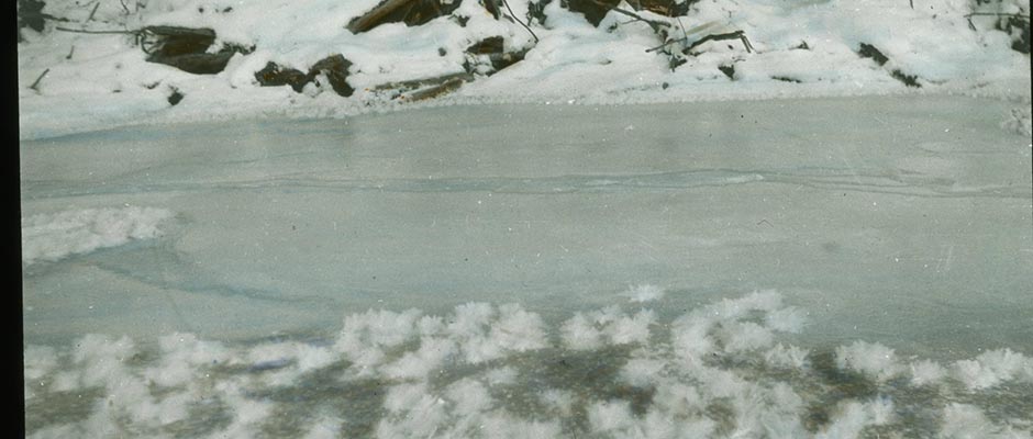
Figs. 18, 19 and to snow (Fig. 18) and surface drainage. In general, avoid routes across
ground showing evidence of creeping or marked swelling. Use sidehill [ ?]
cuts sparingly because they a re vulnerable to fields of surface ice (Fig. 19). ✓
031a | Vol_IIA-0100
Figure 19. Surface ice resulting from seepage in a sidehill
cut.Figure 20. Profile of a permafrost layer near a river.
032 | Vol_IIA-0101
EA-I. U.S. Army Eng: Problems in Permafrost Regions
Wherever possible, build up roadbeds by hauling in granular fill material. On
flat terrain, grade the shoulders of roads to a maximum slope of about $
5:1 to reduce the snowdrift hazard. Where, at a selected site, an access
road must be built over bottom land underlain at a shallow depth by permafrost,
the following procedure is recommended:1. Survey the proposed layout during seasonable weather, avoiding rough
terrain and marshes as much as possible.2. Take advantage in location of any existing brush, timbered areas, and
borrow pits.3. Delay construction operations until the surface has frozen to a suffi–
cient depth to permit construction equipment to be [ ?] operated thereon without
making ruts.4. Use the brush and timber to lay a corduroy base directly on the cleared
roadway. Do not disturb the existing ground surface more than necessary.5. Place a granular mat on the corduroy base thick enough to provide grade
and surface drainage. The lower layer of this mat should be all clean sand or
dense graded sand-gravel to get best results. It should not be coarse gravel or
rock.6. A minimum of three feet of fill has been found desirable. After the
Fig. 20 spring break-up period, only minor fill and regarding operations are normally
required. Avoid locations directly over a [ ?] pronounced dip in the permafrost
(Fig. 20).
033 | Vol_IIA-0102
EA-I. U.S. Army Eng: Problems in Permafrost Regions
Establishing Grade Lines and Cross Sections
In establishing the elevation of longitudinal grade lines, and the shape
of cross sections, the following principles govern:1. Use fill sections and avoid cut sections wherever possible. Cut s in the ✓
natural subgrade are likely to produce failures in bearing capacity, interference
in subgrade drainage, and surface-ice conditions. They are slow in frozen soils
and are hard on equipment.page no. to be inscribed on final proofs. 2. Determine the thickness of base as described on p. . This thickness
must be allowed for in establishing the grade line.3. Where the active zone is composed entirely of frost-action materials
(fines) and does not exceed 5 feet in thickness, immediately underlain by a
thick layer of nonfrost action materials, all frost-action material should be
excavated. Where the thickness of frost-action materials exceeds 5 feet, fills
should be placed directly on the natural ground surface. Backfill operations,
using previously stockpiled granular materials, should be commenced immediately
following excavation operations and conducted to an elevation to provide ade–
quate surface drainage.4. The base course should extend the full width of the runway and shoulders
and be sloped and feathered out beyond those limits.Drainage System and Structures for Airfields
Basic Considerations . Experience in the Arctic and Subarctic has shown that
[ ?] properly built drainage systems are those which interfere least with the
natural movement of water. Where portions of the natural drainage system are
altered, an artificial system of similar [ ?] characteristics must be provided.
All drainage systems are constructed in accordance with the general principles
034 | Vol_IIA-0103
EA-I. U.S. Army Eng: Problems in Permafrost Regions
used in temperate zones. Take special precautions to prevent freezing and
make a liberal estimate of the hydraulic capacity required for the drains.Surface Drainage . In the Arctic, surface water from rain, melting snow,
and ice present s a different problem from that encountered in temperate zones.
Surface water freezes during the winter, and ice is a hazard to operations
and construction. Snow is generally stable until the spring break-up occurs.Once thawing starts, it is usually continuous. Therefore, consideration
is given to:1. Building shoulders between edges of runway and side collection channels
Fig. 21 wide enough for storing snow (Fig. 21).2. Protecting channels against erosion by using checks or a channel lining.
Use natural materials such as moss or sod only as a temporary expedient.3. Ma r king culverts large enough to handle flood conditions during the ✓
spring break-up.4. Using deep, narrow culverts in preference to the conventional wide,
shallow ones. Where necessary, steam pipes to permit easy thawing by portag ✓
portable boilers should be placed in the culverts.Subdrainage . In areas where the mean annual temperature is below freezing,
subdrainage may not be effective because of the difficulty in preventing freez–
ing of the subdrainage system.Surface Ice Control . In most cases, formations of surface ice can best be
controlled by:1. Intercepting and conveying ground water at a safe distance uphill from
the vital area.
034a | Vol_IIA-0104
Figure 21. Suggested shape for runway side collection
channels.Figure 22. Suggested method of creating an induced
field of surface ice.
035 | Vol_IIA-0105
EA-I. U.S. Army Eng: Problems in Permafrost Regions
2. Properly protecting and conveying surface drainage.
3. Constructing induced fields of surface ice outside of operating zones.
This entails creating a plane of weakness by first clearing a strip of trees,
vegetation, and snow, and constructing a ditch and dike perpendicular to the
direction of ground-water movement. Induced icing fields should be established
as far from the structure as possible to provide sufficient ice-storage capacity.
This will prevent overrunning the facility by ice, since ice does not pool like
Figs. 22-23 water but builds up downslope (see Figs. 22 and 23).Drainage Systems and Structures for Roads
Basic Considerations . The principles of airfield drainage previously
described also apply to road construction. However, more drainage problems
are involved since access roads usually traverse much rougher terrain.Surface Drainage . In draining surface water:
1. Reduce possibilities of fields of surface ice by providing an adequate
number of structures to discharge water into natural drains away from a road.2. Construct ditches and dikes to intercept sidehill drainage.
3. Locate side ditches as far from the crown of the road as practicable.
4. Use deep, narrow ditches in preference to wide, shallow ones. The
thickness of surface ice would be the same on both, but the depth of water in
the narrow, deep ditch allows free flow later than in the shallow ditch.5. Provide adequate checks to prevent erosion in side ditches.
6. Drain all excavations made near the roadbed, such as borrow pits.
7. Make culvert sections approximately the same shape as the channel for
cross drainage. Deep, narrow sections are preferable. Where necessary, steam
pipes, to permit thawing by portable boilers, should be placed in these culverts.
035a | Vol_IIA-0106
Figure 23. Induced field of surface ice.
Figure 24. Quonset hut damaged by deep snowdrift which
036 | Vol_IIA-0107
EA-I. U.S. Army Eng: Problems in Permafrost Regions
8. Make bridges and approaches high enough to clear river ice, as well
as icing caused by bridge abutments and piers. Provide icebreakers on all
piers. All available data on previous high water, ice jams, and so forth,
should be used in deciding on the type of bridge and floor clearance.Surface Ice Control . Preventive measure for the control of fields of
surface ice along roads are much the same as those outlined for airfields.In road construction, fields of surface ice at shallow stream crossings
can best be prevented from forming by creating planes of weakness parallel to
the road and 50 to 100 feet upstream. These planes of weakness are created
by ditches and dikes extending into both banks of the stream or by a log
barrier built in the stream channel 500 to 600 feet upstream from the road.
In each individual case, considerable experimentation may be necessary to
obtain the desired results.When the method just described is not practicable, as in the case of
surface ice produced adjacent to the roadbed by deep ground fissures, an “ice
fence” should be used. Ice fences are composed of any waterproof or water–
repellent c loth fabric or metal material held in place by vertical posts
spaced as in a barbed-wire fence. When surface water is momentarily stopped
by the fence and freezes in place, no further stress is exerted against the
fence up to the level of the ice. An ice fence may be increased to a height
limited only by availability of fence material or by need for volume of ice
control. By this method, surface ice can be brought to a vertical wall of
control within a few feet of the roadway.In all cases of surface-ice control, adequate drainage features must be
provided for meltwater when the spring thaw occurs. The drainage factor
will be in direct proportion to the surface area of the ice fields.
037 | Vol_IIA-0108
EA-I. U.S. Army Eng: Problems in Permafrost Regions
Base Courses
General . Base courses constructed in permafrost regions must, in combina–
tion with any fill materials, either insulate the permafrost from a rise in
temperature or provide sufficient support for uniform settlement when the
permafrost thaws. On nonuniform subgrade, it is necessary to protect against
differential heaving. This usually requires placing nonfrost-action sand and
gravel fills to a sufficient depth to equalize the differential movements.
On uniform frost-action soils, it is necessary to provide a base course only
thick enough to transmit loads to the subgrade of considerably reduced bearing
capacity so that settlement, if any, will be relatively uniform and the pave–
ment will not be severely damaged. All subgrade soils have extremely high
load-carrying capacity when frozen, but thawed fine-grained soils are likely
to become saturated and be of low supporting value. In all cases, it is
recommended that: ( 1 ) moving groud water be intercepted and diverted from
pavements and ( 2 ) adequate provisions be made for constant maintenance to
correct unequal settlements and keep the field safe for operation.Heat and Frost Penetration . Where heat penetrates though the runway and
thaws the underlying frozen fine-grained subsoil, the result is saturation,
loss of stability, and attendant settlement.Where winter freezing penetrates the runway deep enough to interrupt the
normal flow of ground water, excessive swelling or formation of fields or
surface ice occur in the fine-grained material in the subgrade. A typical
example is a runway kept free of insulating snow: frost penetrates the runway
and granular base much faster than it would penetrate ground covered with
snow and other natural surface covering. If previous groundwater fluctuation
data are available, they should be studied in connection with the drainage
design for construction.
038 | Vol_IIA-0109
EA-I. U.S. Army Eng: Problems in Permafrost Regions
Special Insulation Layers . Field tests have shown that after about
six months the value of natural insulation such as logs, brush, and moss,
and of commercial insulation such as zonolite, foam glass, and cell concrete
is negligible when used in or below granular base runway fills on frozen,
fine-grained soils in arctic and subarctic regions.Limitations of CBR Curves . In permafrost regions, the California bearing
ration (CBR) is of limited usefulness in evaluating subgrades of soils subject
to frost action. In the first place, it is extremely difficult to determine
true-in-place CBR values when soils are saturated and thawed. Secondly, if
true values are obtained, they may be below 3 per cent and therefore of no
significance on design curves. For these reasons, this method of estimating
base thickness should be used only with subgrades of nonfrost-action material.Basic of Design . In permafrost regions there are, in general, three
subgrade conditions which will affect the design of airfield pavements.
These are:1. Subgrades on nonfrost-active soils. In this case, a base-course design
used in temperate climates can be used.2. Subgrades composed of uniform frost-active soils. In this case, the
design is based on the reduced strength of the subgrade during the thaw period.3. Subgrades composed of nonuniform soils. This condition may result in
differential heaving and settlement and produce a rough pavement surface. If
the pavement area is predominantly sand and gravels with pockets of silty soils,
the silty pockets should be removed and backfilled with granular materials.
However, if the predominant soil type is a silty soil, and the active zone is
shallow, it will be necessary to protect the entire pavement area by providing
a base course to the full depth of the active zone, not to exceed five feet.
Areas of nonuniform soil conditions should be avoided whenever possible, as
039 | Vol_IIA-0110
EA-I. U.S. Army Eng: Problems in Permafrost Regions
airfield pavement construction in those areas greatly increases the time
and yardage.Materials . Soils subject to frost action are well-graded soils con–
taining more than 3 per cent by dry weight of particles less than 0.02 mm.
in size, and uniformly graded soils containing more than 10 per cent of
particles less than 0.02 mm. For base-course materials, use only nonfrost–
susceptible clean sands and gravels.Construction Requirements for Base Courses
The following procedures are recommended.
In placing base material on saturated subgrades, it is especially impor–
tant to provide an escape for excess water so it will be force s d out of the
soil as the fill is placed. If the soil is sufficiently coarse-grained to
allow internal drainage, this can be done by digging shallow wells or sumps,
backfilling them with granular material and connecting them with subdrains
leading away from the construction site. If subgrade moisture content is
reduced in this way, immediate and better compaction is possible and subsequent
settlement in the completed base course is minimized. Excavation of frozen
ground should be avoided.The first layer of base course on subgrades of fine-grained soil should
be clean sand or dense-graded sand-gravel; it should not be coarse gravel or
rock with voids through which the fine-grained soil, when soft, will ooze up
through coarse material into the base. Generally, the Arctic does not provide
a choice of well-graded material and an intermixing of base course and subgrade
may occur.Surfaces
General . Because some settlement almost always occurs with base courses
040 | Vol_IIA-0111
EA-I. U.S. Army Eng: Problems in Permafrost Regions
constructed over permafrost, it is advisable to construct temporary surfaces
and to provide for extensive and continuous maintenance until subgrade condi–
tions become stable. Steel L l anding mats or light bituminous surface treatments ✓
are recommended. After the subgrade and base course have become stabilized,
a higher type pavement may be justified. This may be bituminous (flexible)
type or Portland-cement concrete (rigid) type.Wood and Steel Landing Mats . Wood landing mats are not considered desirable
in arctic and subarctic regions. Steel landing mats should be placed without
sealing the base course so wet or soft spots that develop will be more quickly
detected. Large settlements can be corrected by removing sections of the mat
and excavating and backfilling. Small settlements can be corrected by making
fills through openings in the panels.Pavements . High-type bituminous or concrete pavements should not be con–
structed until it is known that the base and subgrade conditions are stable.
Bituminous pavements are preferred because of their flexibility, economy, ease
of placement, and longer placing season.Corduroy roads are practical in swampy areas underlain by fine-grained
soil. Consideration should be given to this type of construction, particularly
where timber is readily available and satisfactory fill material is scarce.Precautions in Grading Operations
Grading operations in frozen material are very difficult and slow. They
should be avoided whenever possible, unless the material to be graded is
gravel or dry sand. During warm weather, allow each horizontal layer to thaw
before removal. Stripped frozen ground thaws from 2 inches to 6 inches a day in the [(words marking)?]
summer, depending on its heat conductivity property, the temperature and surface
velocity of the air, and the amount of direct radiant heat from the sun.
041 | Vol_IIA-0112
EA-I. U.S. Army Eng: Problems in Permafrost Regions
In making fills on frozen ground, the sides of ravines, gullies, and pot
holes are roughened by cutting or blasting to prevent the new ground from
slipping. A few light cuts along the contours on a hillside will improve
the bond between the foundation and embankment. Such o c uts must be extended ✓
beyond the limits of the embankment to provide outlets for intercepted
water.Full advantage should be taken of soils found in excavations to maintain
or create uniform soil conditions in embankments. Pockets of unsatisfactory
material in the cuts or over which embankments are being placed should be ✓
replaced with material comparable to that in adjacent ground.Surface drainage should be provided in all work areas to prevent accumula–
tion of water and slushy ground surface.Tie-down Anchors and Markings
Tie-down anchors are provided for parked planes to prevent damage from
high winds. Adequate markers along runways, taxiways, roads, and at culverts,
drainage ditches, and inlets must be installed to define their position clearly
when snow-covered. During poor weather conditions in arctic and subarctic
winters, with no sun and shadow, unmarked snow-covered roads are extremely
difficult to distinguish.BUILDINGS
I. LOCATION AND DESIGN
This section discusses the fundamentals of building location and design
on permafrost. Designs illustrated have been successfully used but need not
be followed in detail. Type of design selected depends on local soil and
climatic conditions. Details depend on construction materials available.
042 | Vol_IIA-0113
EA-I. U.S. Army Eng: Problems in Permafrost Regions
Where permafrost does not exist, building construction is similar to that
in any region subject to normal frost action.Location Factors
The general location of a building is dictated by its relationship to a
building group or project. Administrative, service, and dispersion require–
ments further restrict a building site, but the exact site should be chosen
only after a study of the following factors.Character of Foundation . Stability of foundation material and existence
of moving groundwater are the crucial factors affecting building location and
design on permafrost. Surface and subsurface conditions are frequently so
variable that a change in location of only a few hundred feet results in much
improved conditions. It is especially important to avoid ground containing
layers or lenses of ice, or areas subject to irregular swelling and settling.Snowdrifts . In areas subject to strong winds, snowdrifts can cause extensive
damage. Buildings should not be benched into hillsides where snow can drift
Fig. 24 deep between the sides of the building and the excavation (Fig. 24). This
causes severe stresse d s which may push the top of the building out of alignment ✓
or even destroy the entire structure. Snowslides and landslides as well as
drifting snow may occur on hills with steep slopes, especially those that face
the hottest sun. Gullies, valleys, and depressions are subject to deep drifting
snow. Building in such areas should be avoided.Winds. Arctic regions are frequently subject to high velocity winds.
Since sheltered areas are generally not available, consideration is given to:
( a ) locating buildings with their long axis parallel to the direction of
prevailing winds and ( b ) locating facilities, such as mess halls and latrines,
near barracks. Although this is commonly done in all camps, it should be rigidly
practiced in arctic construction.
043 | Vol_IIA-0114
EA-I. U.S. Army Eng: Problems in Permafrost Regions
Exposure. Wherever possible, living quarters should face the sun and
be on the sunny slope to take advantage of radiant heat and sunlight.Drainage. Site that are well drained and free from evidence of ground
movement and surface ice are best.Dispersion. Building groups should be separated to minimize fire hazard.
Coordinate grouping with local ground conditions to hold the length of utility
distribution lines to the minimum.Principles of Foundation Design on Permafrost
Building construction frequently alters and thermal regime of the ground
to such an extent that permafrost thaws. If the ground is of fine-grained,
frost-acting material, its load-carrying capacity is reduced. Therefore, unless
positive measures are taken to preserve the permafrost, foundations must be
designed for the bearing capacity of the foundation material in a thawed condition.
The decision depends on the following factors:-
Types of building, heated or unheated.
-
Area of floor space and type of loading.
-
Moisture content of foundation material and amount of water available
for ice growth. -
Bearing capacity of foundation material both when thawed and when
frozen, and differences in ground texture. -
Depths of frost and active zones.
-
Area, extent, and temperature of permafrost.
-
Groundwater movement.
-
Type and amount of insulative material normally in the ground throughout
the year.
044 | Vol_IIA-0115
EA-I. U.S. Army Eng: Problems in Permafrost Regions
Foundation Problems
Materials for foundation structures must resist shear and tension
stresses. Wood and monolithic concrete are acceptable; masonry and brick
are not.Lifting and Settling. A foundation resting on permafrost is subject to
stresses which either lift it or cause it to settle. This is particularly
true in locations where the active zone and the frost zone are normally
identical and the surface layer of moss and peat is underlain by fine-grained,
frost-acting soils down to the permafrost. In these instances, unless specific
precautions are taken, irregular settlement and damage to foundations occur.
Lifting is caused by the swelling of material in the active zone which has
frozen to the foundation, or by the formation of ice under the base of the
foundation. Settling results when permafrost thaws. This may be caused by
moving groundwater, heat from buildings, or by increased heat penetration due
to removal of natural surface insulation.The use of muffs, collars, or greasings around that portion of the pile
in the active zone, to lessen the lifting effect of swelling materials, is
effective for approximately one season. Piling adequately anchored in perma–
frost will not be disturbed by such uplifting forces.The truncated-pyramid type of reinforced-concrete footing, supported on or
at a slight depth below the upper surface of the permafrost, shows a tendency
to heave and should not be used.Air Circulation. To preserve the permafrost, it is necessary to provide an
air space of about 2 feet between the floor and the ground surface to permit
air circulation and dissipation of heat from the structure. The shading effect
of the building also assists in maintaining permafrost. A l-foot air space
045 | Vol_IIA-0116
EA-I. U.S. Army Eng: Problems in Permafrost Regions
may be used on small buildings up to about 30 feet square. On larger
buildings the sun beating on the southerly side of the structure (in the
Northern Hemisphere) during the long summer days causes a deeper thaw than
on the north side. To prevent such thawing, place vented sloping shields
on the east, south, and west portions to shield the base from the sun.
During freezing weather, remove the shields to allow free circulation of
Fig. 25 the cold air. ( A typical design is shown in Figure 25. ✓Formation of Surface Ice . Moving groundwater, especially if under hydro–
static pressure, may seep to the surface and freeze with destructive effects.
Seepage is most likely to occur along the contact surfaces of piles or
foundations, but may occur at any place under an improperly insulated heated
building.Surface Foundations
General . Foundations for buildings may consist of treated timber footings
placed on the surface of the ground. These are especially suitable if:1. The active zone is comprised of nonfrost-acting sand and gravel, con–
taining less than 3 per cent by dry weight of particles less than 0.02 mm.2. The building floor is properly insulated and an air space is provided
Fig. 26 to prevent transmission of heat into the underlying permafrost (see Fig. 26).Permafrost . On rare occasions, the active zone is well-drained granular
material not subject to swelling and the underlying permafrost consists of
granular nonfrost-acting material to depths in excess of 40 feet without
lenses or layers of ice. Under those conditions, temporary construction
methods, similar to those employed in temperate zones, may be used. Actually
the permafrost under large constantly heated buildings may be thawed much
deeper than 40 feet over a period of several years. If there is a subpermafrost
045a | Vol_IIA-0117
Figure 25. Typical design for structure where permafrost is to
be maintained by proper insulation and ventilation.
045b | Vol_IIA-0118
Figure 26. Design for small temporary structure on gravel
mat with air space.
046 | Vol_IIA-0119
EA-I. U.S. Army Eng: Problems in Permafrost Regions
water table under abnormal pressure below this depth (40 feet), the water
rises through the coarse material. It may then present a drainage or
surface ice problem. The solution is to investigate by drilling as deep
as the maximum expected level of thaw.Thawed Permafrost . Provision may have to be made for heavy floor loads
such as heating plants, power plants, hangars, and similar structures. Where
subsurface examinations show that the combined depth of the active zone and
the underlying permafrost is not in excess of 30 to 50 feet, stable foundations
may be obtained in the following manner: ( 1 ) thaw through the existing perma–
frost under the proposed building area by either steam or cold water methods;
( 2 ) compact the subgrade; and ( 3 ) construct the foundations, using standard
methods.Gravel Mats
Temporary or Lightweight Structures . Foundation difficulties are generally
encountered in arctic and subarctic areas where the moss and peat covered
surface is underlain by fine-grained, frost-acting soils. This is particularly
true where the depth of frost in the active zone and the surface of the perma–
frost layer join almost every winter seasonally, and the maximum depth of the
active zone is from 2 to 5 feet. Since gravel is not an adequate insulation
but serves more as a cushion to distribute the load and equalize settlement,
its sole use as a foundation mat for heavy permanent structures is not recom–
mended. However, for temporary or lightweight structures with relatively light
floor loads, these construction methods are recommended:1. Remove trees and brush carefully to reduce disturbance of the existing
natural surface vegetation.
047 | Vol_IIA-0120
EA-I. U.S. Army Eng: Problems in Permafrost Regions
2. Place about 6 inches of clear sand over the cleared surface. Follow
with a well-compacted sand and gravel fill to an elevation above the normal
ground surface to insure satisfactory drainage. A minimum of 2 to 4 feet is
necessary. The fill m o u st extend well beyond the limits of the structure and ✓
be sloped to provide adequate surface drainage.3. Erect the building proper on firmly placed, treated timber sills,
spaced to support the designed floor loads and also to provide an air space
between the bottom of the floor and the top of fill.4. It is desirable to make provisions for insulated floors, both for
comfort of personnel and reduction of heat penetration into the underlying
air space (see Fig. 25).5. In fine-grained soils, ground-water flow is generally very slow. It
normally causes no difficulty if the thermal regime of the permafrost is main–
tained by proper construction. Surface water from snow-melt and precipitation
can be suitably controlled by proper surface drainage.Heavy Permanent Structures . In permafrost areas, stable foundation con–
struction on gravel mats of large, heavy structures such as hangars is difficult,
expensive, and not generally recommended. Exceptions to this are where accurate
and extensive subsurface explorations show that there is a permafrost layer
below the active zone of ample area and depth (more than 50 feet) and comprised
of fairly dense granular material devoid of ice lenses and layers. In such
instances, construction operations should be accomplished in the following
Figs. 27-28 sequence and manner (see Figs. 27 and 28).1. Stockpils an ample supply of graded granular material in the near
vicinity of the site of the proposed foundation. This prevents subsequent delay
in construction operations due to failure of haul roads which is common in these
areas.
047a | Vol_IIA-0121
Figure 27. Building being constructed on a gravel mat in an area
where the surface vegetation has been removed. Fill
should be extended to provide adequate surface drain–
age. Floor should be insulated.Figure 28. Large hangar being constructed on a gravel mat in an area
where all fine-grained frost-acting soils have been removed
to an average depth of approximately 2 feet below the upper
surface of the permafrost layer.
048 | Vol_IIA-0122
EA-I. U.S. Army Eng: Problems in Permafrost Regions
2. Lay out the area to be stripped and excavated sufficiently in excess
of the perimeter of the proposed structure foundation to afford a good working
area.3. Strip surface moss and peat and underlying fine-grained, frost-acting
materials in the active zone and continue excavation to depths of approximately
2 feet below the surface of the existing permafrost layer. Large tractor-drawn
carryalls have proved satisfactory for these operations, particularly when work
is scheduled to take advantage of summer thaw. During summer periods, the
frozen subsoils will thaw approximately 3 inches daily. By continuous operations,
it can be removed at this rate until the required depths are reached.4. Use the stockpiled granular materials in backfilling operations.
Commence immediately after the excavation is finished in order to preserve the
underlying permafrost and to facilitate construction. Fill materials should be
placed and compacted in approximately 6-inch layers to a minimum elevation of
3 feet above the surrounding ground surface, on an area well in excess of the
perimeter of the foundation so that future grading and drainage operations can
be accomplished.5. After placing and compacting the fill, specific excavations for the
proposed foundation piers or footings may be made.6. To avoid the transmission of excess heat through the gravel mat founda–
tions of the large structures such as hangars and barracks, water, st r eam, and ✓
sewerage should be supplied to them by overground, insulate utilidors.Piles
A foundation resting on permafrost is subject to stresses which lift it or
cause it to settle. This is particularly true in locations where the active
zone consists of fine-grained frost-acting soils. In areas where vertical
049 | Vol_IIA-0123
EA-I. U.S. Army Eng: Problems in Permafrost Regions
stability is a governing design factor, vital utility structures, such as
power plants, boiler houses, water tanks, fire stations, and radio towers,
should be so supported on treated timber, reinforced concrete, or steel
piling as to provide an air space between the floor of the structure and
the ground surface. Before piles can be placed in permafrost, a hole must
be drilled or thawed by means of a steam or water jet. A minimum spacing
of 8 feet may be used if piles are placed in drilled holes. Steam or water
thawing must be done with extreme care to prevent thawing out the entire
building foundation area; usually pile spacing in this case should be greater
than 6 feet. Normal design would space the piling at 10- to 14-foot intervals.
For very heavy construction, excellent results are obtained by using 8-inch–
diameter, standard-weight steel pipe as piling on 5-foot centers in churn-drilled
Fig. 29 holes. In Figure 29, it will be noted that initially the bulk of the pile load
is carried by point resistance until the adjoining permafrost refreezes. The
most satisfactory time for placing foundation piles is during the fall and
early winter. Pile foundations require:1. Provision of an air space and other insulation in the design to
dissipate heat and prevent thawing the permafrost.2. Use of either treated timber, precast reinforced concrete, or steel
piling. Steel pipe may also be used.3. In general, reinforced concrete and steel piling should be uniform in
cross section throughout their length. Treated timber piling should be installed
butt down.4. Installation of piling into the permafrost should be to a depth of at
least twice the thickness of the existing active zone. Do not let thawed or
drilled holes stand open for long periods before placing piles, since the hole
may freeze up in cold weather or thaw to a detrimental radius during the warm
weather.
049a | Vol_IIA-0124
Figure 29. Typical design for structures where permafrost is to
be maintained by insulation and ventilation by support–
ing on timber, steel, or concrete piles.
050 | Vol_IIA-0125
EA-I. U.S. Army Eng: Problems in Permafrost Regions
. 30 Figure 30 shows several important utility structures supported on piling.
These structures have not settled and have given excellent service.Factors in Building Design
In the interior of Alaska, buildings should be designed for temperatures
of −60°F. and wind velocities of 40 miles per hour, and, in the coastal areas,
for temperatures of −50°F. and wind velocities of 60 miles per hour. The use
of insulated floors, ceilings, and walls is necessary to provide comfort to
personnel, ease and economy of heating, and reduction in the formation of
ice on the roof.Floors should be well insulated to prevent thawing the underlying ground
and lowering the permafrost below the foundation base. A recommended design
is shown in Figure 29.Roof Loading . Roofs must be able to withstand heavy snow loads and strong
winds. When heavy snows accompanied by winds and temperatures well below
freezing are followed by short periods of thawing temperatures, alternate
layers of snow and ice form on roofs. The thickness of these layers depends
on the exposure of the structure.1. Snowfall. The amount of snowfall (Table III) at any station varies with
its location. There is a gradation from a minimum in the polar regions to
larger amounts in the subarctic, with the heaviest snowfall occurring along
the coastal mountain slopes.2. Wind Velocities. Records show that along the Bering Sea coast line
wind velocities higher than 70 miles per hour can be expected. The maximum
recorded velocity to date was 73 m.p.h. at Nome, Alaska, on October 27, 1946.
The average yearly maximum velocity at this location for the period of record
is 48.7 m.p.h. Along the arctic coast line, the maximum recorded velocity to
050a | Vol_IIA-0126
Figure 30. Operational structures at the Northway, Alaska, Aairfield.
The boilerhouse, center foreground, is constructed on a re–
inforced - concrete floor slab, supported on timber piling placed
well into the permafrost in such manner as to provide about a
2-foot air space. The 100,000-gallon water tank, right rear,
is constructed on a reinforced-concrete base supported by
asphalt-coated piling extending through the gravel mat to a
depth of 4 feet in the underlying permafrost. The insulated
tank was constructed on crossbeams placed on the surface of
the concrete slab so as to provide an air space of about 2
feet. The power house, left rear, is supported on a reinforced -
concrete foundation slab placed on compacted granular fill in
an area where the existing moss, peat, and underlying fine–
grained soils were previously steamed and excavated to a
depth of 9 feet below the normal ground surface (winter work).
051 | Vol_IIA-0127
EA-I. U.S. Army Eng: Problems in Permafrost Regions
date was 54.0 m.p.h. at Barrow, Alaska, on March 30, 1935. The average
yearly maximum velocity at this location for the period of record is
45.8 m.p.h. In interior Alaska, the maximum recorded velocity to date was
46.0 m.p.h. at Fairbanks, Alaska, on October 30, 1946. The average yearly
maximum velocity at this location for the period of record is 32.4 m.p.h.Table III. Snowfall at Selected Points. Station Period
of
record, yr.Average
annual, in.Monthly
maximum,
average, in.Barrow 18 36.3 9 Kotzebue 7 46.9 1.5 Nome 31 67.2 11 Bethel 17 42.3 10 Tanana 5 60.7 11 Fairbanks 31 55.9 11 McKinley Park 10 76.7 19
Roofing Details . Eaves should not be used where there are extremely high
winds, because they will have no function except to weaken the structure. If
they are used in areas having less severe winds, the wind-cave factor should
be used in the design of the building. When the use of caves is required for
sheltering purposes, high winds must be considered in the design.High winds have a destructive effect on roof covering, particularly on
the low-pressure leeward side. The best roofs are the built-up type, con–
sisting of a base sheet of 30-pound bituminous-saturated felt nailed with
large-head roofing nails spaced not more than 6 inches apart horizontally and
12 inches apart vertically, followed by one or two layers of 15-pound bituminous–
saturated felt mopped onto the base sheet with hot asphalt. Battens or wood
strippings must be nailed securely to hold down felt and paper.
052 | Vol_IIA-0128
EA-I. U.S. Army Eng: Problems in Permafrost Regions
Doors . Exterior doors should swing inward, as standard-opening doors
may be blown off by high winds or blocked by drifting snow. In echelon
shops and garages where floor space is at a premium, rolling or sliding
overhead doors may be used.Structure Details . Building frames for arctic coastal regions must be
designed to resist stresse d s caused by wind velocities up to 100 m.p.h. ✓
Design should provide for:1. Anchoring of walls to foundations by bolts, reinforcing steel, or
cleats.2. Anchoring of structures, especially those supported by concrete slab
foundations, by cables and deadmen. In locations where the active zone
consists of fine-grained, frost-acting soils, immediately underlain by perma–
frost, arrangements should be made to bury the deadmen at least 4 feet below
the upper surface of the permafrost layer, parallel to moving groundwater.3. Fastening of roof trusses and rafters securely to the frame.
4. Use either diagonal braces or sheathing for rigidity.
Earthquakes . Many parts of Alaska are subject to earthquakes. Intensities
of 3 to 4 or greater on the Modified Mercalli Intensity scale are not uncommon.
In the Tanana Valley, a maximum shock force of 8 plus has been recorded. Past
history indicates that similar earthquakes may occur at intervals of 10 years.
Design of large structures, particularly hangars and water tanks, must provide
against additional stresses caused by earthquake shocks.Heating . Individual heating units are more satisfactory and economical
than central heating plants, except in large permanent installations. Use
unit-type oil heaters with spark ignition to eliminate explosions from
downdrafts; also oil is the fuel most economical to transport. Chimneys
053 | Vol_IIA-0129
EA-I. U.S. Army Eng: Problems in Permafrost Regions
should be extended well above the top of all nearly buildings and located
and constructed so wind will not cause downdrafts. To prevent the escape
of heat during periods of high winds and low temperatures, buildings should
be well insulated and weather-stripped. A double door or storm vestibule
is necessary at each entrance. Adequate ventilation by means of a vent near
the top of the structure minimizes condensation. Proper ventilation aids
in preventing asphyxiation from the odorless carbon monoxide gas generated
by heating fuels.Central heating plants may be used to serve a group of buildings in large
installations. Steam, water, and sewer lines should be placed in common
overground or underground heated, insulated utilidors. The vacuum return
line system of steam distribution provides positive circulation and permits
the use of smaller pipes. Thermostatic traps must be well protected from
freezing temperature, and each riser must be dripped at the bottom through
a thermostatic trap. In areas where the active zone is seasonally joined to
the permafrost, in the interest of fire protection, and the preservation of
the permafrost, boiler and powerhouse units should not be constructed as
integral parts of large structures. They should be built as independent units.Adequate fire prevention and fire-fighting measures must be taken. Fire
mains should be inclosed in insulated, heated utilidors. Proper spacing of
buildings will help prevent fires from spreading.Drying Clothes . All living quarters must be designed with adequate facili–
ties for removing, cleaning, and drying wet and muddy clothes. To avoid
objectionable humidity and odor in the main sleeping quarters, provide a
separate room or vestibule near the entrance to the building. Warm circulating
air is required. Heater r d air from other rooms can be circulated through the ✓
054 | Vol_IIA-0130
EA-I. U.S. Army Eng: Problems in Permafrost Regions
drying room and then discharged from the building.Power and Communication Lines
General . Owing to the need of continuous operation of power and
communication lines, they should not be routed through inclosed utilidors.
To provide easy access, they should be supported on poles. The temperature
range and sag curves should be considered in establishing the pole spacing.Pole Construction . In areas where the active zone and underlying perma–
frost is composed of granular nonfrost-acting soil, pole erection may be
accomplished by methods similar to those used in temperate zones. In areas
where both the active zone and underlying permafrost are composed of fine–
grained, frost-acting materials, pole installation should be done in one of
the following ways:1. Place treated butt poles into the permafrost to a depth about twice
the thickness of the active zone. For suspension or sharp turns, provide for
the additional stresses incurred by installing additional butt poles and
adequate guy wires, or by using H-frame construction.2. In marshy terrain, it may be necessary to use cross-braced rock-filled
cribs for pole foundations.3. For temporary installations, construct a tripod of three poles with
a suspended weight from the apex, or fasten guy wires to crosspieces bolted
to the weighted bottom of the pole.II. CONSTRUCTION
General Consideration
The effect of nearly construction must be carefully considered in project
planning. Nearby buildings, utility lines, roads or streets, sidewalks, and
drainage ditches may alter the thermal regime of the ground underlying the ✓
055 | Vol_IIA-0131
EA-I. U.S. Army Eng: Problems in Permafrost Regions
the proposed structure. Care must also be taken that construction equipment
does not disturb or destroy the natural peat or moss insulation on top of
the ground, except where called for in design.Foundation Construction
Piles (Forced Thawing). If drilling into the permafrost is impracticable,
Fig. 31 the thawing methods may be used (see Fig. 31). Steam and water jetting are
the most satisfactory methods of thawing and can be used in most types of
Fig. 32 soils. Typical steam and water jets are illustrated in Figure 32. Steam
at 30 pounds per square inch is satisfactory for depths up to 15 to 20 feet.
For greater depths, larger pipe and higher steam pressures must be used.
The pipe must be hammered lightly into the ground. The use of scaffolding on
A-frame facilitates handling long pipes.Once the necessary depth has been reached, keep the steam point in the
hole from 1/2 hour for sandy soils to 3 hours for clayey soils to make the
hole large enough to place the pile. The important thing is to disturb the
Fig. 33 thermal regime of the soil as little as possible. Figure 33 shows the approxi–
mate thawed shape in sandy silt soil after 1½ hours of steam jetting.After the hole has been properly thawed, place the pile by the usual
methods. Water jetting is required to place piles if the soil is sandy.
Timber piles have a tendency to float when placed in the thawed hole. They
must, therefore, be weighted or held down until the permafrost has partially
refrozen.Excavation of frozen ground may require blasting, the use of pneumatic
paving breakers, or thawing with water or steam. The cold water method of
thawing used by mining companies in Alaskan placer-mining operations is generally
most economical and produces more uniform thawing action. For small localized
055a | Vol_IIA-0132
Figure 31. Piling driven through 3 feet of active zone
and anchored to a depth of 13 feet in permafrost.Figure 32. Details of steam and water pipe jest. Best jet
depends on type of frozen soil encountered. Jets on
right may be used for water as well as steam.
055b | Vol_IIA-0133
Figure 33. Approximate shape of thawed gravel (sandy silt
soil) after steam point has remained in a 14-foot
hole about 1-1/2 hours.
056 | Vol_IIA-0134
EA-I. U.S. Army Eng: Problems in Permafrost Regions
areas, steam is faster and equally effective. Use steam in the winter
since the water may cause severe icing conditions as it flows toward the
natural drainage.Concrete work in the Arctic is similar to the placing and curing of
concrete in any cold-weather lands. The concrete should be placed at
temperatures above 70°F. This is usually done by heating the aggregate
with perforated steam lines laid under the aggregate piles and by warming
the water. The concrete is then covered with tarpaulins and maintained at
a temperature of 50°F. during the curing period. This period may be reduced
to 48 hours if high-early-strength cement is used. If the heating method
used results in drying the concrete, it should be supplemented by using live
steam. Concrete should not be placed directly on permafrost since the heat
of hydration will melt the permafrost. Precast concrete should be used in
such instances.WATER SUPPLY AND DISTRIBUTION
Developing an adequate water-supply system requires: ( 1 ) selecting a
site; ( 2 ) developing the source; ( 3 ) constructing storage facilities; ( 4 )
treating the water; and ( 5 ) constructing a distribution system.Choice of Site
Choice of site is based on the water-supply data obtained in reconnaissance
and from site surveys. The relative importance of the following items must be
carefully considered in relation to each site.Yield . In arctic and subarctic regions, even though swamps, lakes, and
rivers are a prominent feature of the landscape, the procurement of an adequate
year-round supply of suitable water for drinking, sanitary purposes, construction,
057 | Vol_IIA-0135
EA-I. U.S. Army Eng: Problems in Permafrost Regions
and fire fighting is an extremely difficult problem. Deep wells, tapping water
below the permafrost, are the most reliable source. For surface waters,
several sites may be needed. A further consideration is the possibility that
the demand for water may increase, especially where an installation is to be
improved or expanded. A source having a yield that can be increased is
preferred over a source with a limited yield. Remember that the yield of
groundwater, especially below the permafrost, can usually be increased by
adding wells while the yield of streams, lakes, rivers, or springs is limited.
In some locations where the permafrost layer is thick, deep wells are not
feasible; and other sources, such as rivers and lakes, must be used. In
winter seasons, this often means melting ice, since rivers and lakes are
generally frozen solid.Difficulty of Construction . Choice of site may depend on the type of
construction required at each site. Dams and reservoirs, for example, involve
expensive and elaborate construction and should not be built unless there is
time for detailed surveys. Wells, on the other hand, are more satisfactory
in extremely cold regions.Location . To make distribution easier, the site should be as near the
using area as possible but not so near as to affect groundwater or the thermal
regime at the construction site. The advantages of a good site may often be
offset by the difficulty of pumping water from the source of the installation
being served.Quality . The quality of the water at the source affects the type and
extent of treatment required to make it usable.Temperature . The temperature of the water plays an important part in
distribution-system design. Warm-water sources (above 35°F.) are preferred
to those near freezing.
058 | Vol_IIA-0136
EA-I. U.S. Army Eng: Problems in Permafrost Regions
Development of Source
Rivers and lakes which do not freeze to the bottom in winter because of
their depth s can be developed as water-supply sources by constructing a
collecting basin, channel, or an intake in their middle. River intakes
must be protected against high current velocities, silting, large amounts
of driftwood, and floating ice, especially following the annual ice break-up.
Anchor ice and slush ice tend to clog intakes in winter.Dams and reservoirs can be built to store surface water for use during
the winter months, but they usually create major construction problems. Water
stored in a reservoir may thaw the adjacent and underlying ground, causing it
to cave in and slide into the reservoir. If the underlying ground is permeable,
as shown by borings, the melting of ice particles may start a seri o us leak.
Ground containing layers of ground ice must be carefully explored before a
suitable location is selected.Sunken Areas . In locations where surface moss and peat insulation have been
disturbed or destroyed by fire or other means, subsequent rains and spring flood
waters and other climatic factors may thaw the underlying permafrost causing it to
settle and create small lakes; such lakes are usually shallow and seasonally
frozen to their entire depth. In some instances, they can be enlarged and
deepened by dragline dredging operations to furnish a temporary source of water.
They normally are not a reliable source for a permanent water supply.Collection galleries are the best means of intercepting water from multiple
springs or from the groundwater in unfrozen ground above the permafrost. They
are especially suited to a stratum through which seepage occurs. Collection
galleries should be prepared as follows:Excavate a saucer-shaped hole to the stratum of highest permeability below
the active zone.
059 | Vol_IIA-0137
EA-I. U.S. Army Eng: Problems in Permafrost Regions
2. Install a well point in a perforated steel drum.
3. Place the drum in the excavation.
4. Surround the drum with granular materials, grade the materials from
boulders at the drum to sand at the bottom and edges of the excavation to
give a reverse filter effect.5. Continue backfill to normal grade.
Wells . When sinking wells in permafrost, the following considerations
should be kept in mind.1. Wells can be either drilled or dug. Drilling is preferred because wells
are better protected from silting and pollution by surface waters and are less
likely to be deformed by swelling ground. In some instances drilling is pro–
hibitive due to the excessive thickness of the permafrost layer. Records
show, however, that at one location in Russia an artesian water supply was
obtained by drilling through permafrost to a depth in excess of 500 feet. In
interior Alaska, suitable artesian flows are not uncommon in wells drilled
through permafrost to depths from 100 to 200 feet.2. To prevent silting, caving, and possible pollution, drilled wells
should be cased into the water-bearing strata. Dug wells should be lined. It
is advisable to place wells on high ground to prevent surface infiltration and
pollution. Place the concrete floor slab of the pump house on a foundation to
prevent heaving and settling. The slab should not be bonded to the well casing;
otherwise damage by differential movement between the slab and casing may result.3. While drilling wells through permafrost, the following precautions
should be taken:a. Obtain an ample supply of fitted well casing to permit continuous
24-hour drilling operations.
059a | Vol_IIA-0138
EA-I. U.S. Army Eng: Problems in Permafrost Regions
b. Provide steam (or water) jet and sump pump attachments for the
drill rig to permit immediate advance thawing of the permafrost. This
facilitates driving of the casing. Pumping operations can be started to prevent the
060 | Vol_IIA-0139
EA-I. U.S. Army Eng: Problems in Permafrost Regions
accumulation and packing of fine-grained materials inside the casing.
The problem of freezing in rotary drilling is greatest between drill runs.
Alcohol is used to maintain circulation and to prevent freezing when the
rig is not actually drilling.c. Continue these operations until an adequate granular water-bearing
stratum is encountered and the tip of the casing has been driven some distance
into it.d. Freezing during drilling operations is not a problem if the hole
is kept dry when operations are suspended for any length of time. During the
actual drilling, the hot water prevents freezing.4. The normal water level of a well drilled through permafrost will usually
be within the zone of permafrost. Frequent pumping helps to prevent freezing.
However, prepare to introduce ei her steam or hot water into the well casing
or suction pipes if freezing occurs.Storage
Storage facilities are a necessary part of any water-supply system. They
provide a reserve for peak loads and emergencies such as fire fighting or a
breakdown of pumping equipment. Adequate provisions should be taken to prevent
freezing. Tanks or open basins should be in a heated building and elevated
or outdoor tanks should be properly insulated. Careful design of foundations
for water tanks or storage basins is extremely important.Water Treatment or Purification
The treatment required depends primarily on the source and quality of
supply. All water for the use of personnel must be chlorinated.Surface Water . Water from streams generally requires filtration. Heavily
silt-laden water may also require presedimentation in settling basins. Water
061 | Vol_IIA-0140
EA-I. U.S. Army Eng: Problems in Permafrost Regions
from a lake usually does not need filtering if pump intakes are far
enough from the mouths of streams feeding the lake. Water from swamp
creeks, ponds, or lakes, containing considerable quantities of dissolved
organic matter, requires extensive treatment to remove hardness, unpleasant
odors, and tastes.Groundwater seldom needs filtration but generally requires treatment to underline
remove hardness.Distribution Systems
Water distribution systems, particularly pipelines, present special con–
struction problems in permafrost regions. Adequate measures must be taken
to prevent water freezing in pipelines and to avoid disturbing the thermal
regime in the adjacent ground. Proper design of footings and foundations
for conduits and pipes is specially important. Various methods of overcoming
these problems are discussed in the following paragraphs. Where conditions
are extreme, several methods may have to be combined.Preheating . Preheating, or heating the water at the source to approximately
38°F., is a simple way to prevent freezing in small systems. In long mains,
intermediate heating stations can be provided by running a short length of
small steam pipe within the main. Where the water distribution system is long
or subject to idle periods, it may be necessary to form a loop system or several
loop systems in which the water is kept circulating during cold weather.Pipelaying in Unfrozen Ground . In areas where permafrost is absent to depths
in excess of 15 feet below surface and this zone consists of well-drained,
granular materials, water pipe may be safely used if installed below the lower
limit of the seasonal frost zone. Undisturbed snow cover over pipelines forms
a good insulator. The use of moss as an insulator is discouraged since it is
hard to harvest and dry in quantities.
062 | Vol_IIA-0141
EA-I. U.S. Army Eng: Problems in Permafrost Regions
Pipelaying in Permafrost . Install pipelines in permafrost only when the
soil consists of nonfrost-acting granular material with no ice lenses o f r ✓
layers. Wood-stave pipe is preferred under these conditions. Do not place
pipelines underground in areas where the active zone and underlying permafrost
are compri z s ed of fine-grained, frost-acting soils. Heat transferred from the ✓
pipe will m o e lt the soils and disrupt the lines. In these instances, pipelines ✓
should be placed in overground, insulated conduits (utilidors).Utilidors . Underground, temporary utilidors should be constructed only
in areas where the active zone and underlying permafrost are in well-drained,
nonfrost-acting materials to depths of 15 feet below surface. For small or
temporary installations construct insulated wood box utilidors for steam,
Fig. 34 water, and sewer lines (Fig. 34).1. Carefully stake out the proposed layout from the standpoint of
structures to be served, and to afford necessary grade and alignment.2. Trench-excavate all surface and active-zone materials well in
excess, in depths and widths, of the proposed cross-sectional areas of the
utilidors. This permits final installation to the tolerances shown in Figure 34.3. Construct adequately insulated access manhole d s at all proposed utilidor ✓
junction branches and intersections, and in long runs at intermediate points.4. Place and compact gravel backfill to proper elevations to serve as a
cushion base for embedded treated timber crossbeams. They are placed at
intervals of approximately 10 feet to support the utilidors.5. The final hand and mechanical gravel-backfilling and grading operations
around and over the installed utilidor should be accomplished with care to
avoid damage.
062a | Vol_IIA-0142
Figure 34. Typical Section of Utilidor Below Ground Surface.
063 | Vol_IIA-0143
EA-I. U.S. Army Eng: Problems in Permafrost Regions
For the smaller permanent-type, underground installations, where the
active zone and underlying permafrost are well-drained, nonfrost-acting
materials to depths of 15 feet below the surface, the following method of
construction is recommended. For installations where an access walkway in
the utilidor is not considered necessary, the water, steam, and sewer lines
Fig. 35 may be enclosed in a concrete utilidor similar to that shown in Figure 35.
Provide insulated access manholes at required locations. Monolithic precast
reinforced-concrete deck panels in 6-foot lengths, seated in mastic, for the
top cover provide ready access to the utility lines in case remedial work
is necessary. Specific protective measures should be taken in instances of
roadway crossing over the utilidor.For large permanent installations, where the active zone and underlying
permafrost are well-drained, nonfrost-acting materials to depths of 35 feet
below the surface, it is desirable from the standpoint of efficient servicing
and protection during severe weather that all utilities, with the exception of
high-voltage power lines, be inclosed in underground concrete utilidors with
Fig. 36 access walkways (see Fig. 36).Construct overground utilidors in areas where the active zone and underlying
permafrost usually join and consist of fine-grained, frost-acting soils with
ice lenses and layers. Construction should be accomplished in the following
manner and procedure:1. Carefully stake out the proposed layout from a standpoint of structures
to be served and to afford proper vertical and horizontal grade alignment.
Avoid, if possible, layouts requiring utilidor crossing over heavily traveled
roadways.
063a | Vol_IIA-0144
Figure 35. Typical Section of Permanent-Type Underground Utilidor
Without Walkway.
063b | Vol_IIA-0145
Figure 36. Typical Section of Permanent-Type Underground
With Walkway.
064 | Vol_IIA-0146
EA-I. U.S. Army Eng: Problems in Permafrost Regions
2. Drill or jet holes, using steam or water, to adequate depths and
spacing to permit the installation of treated timber piles (butt down) to
depths in the permafrost of twice the thickness of the active zone (see
Fig. 37 Fig. 37).3. Construct the insulated wooden utilidor on crossbeams placed on
the piles to an elevation providing at least a 2-foot air space.4. Provide insulated access openings at all junction branches and inter–
sections, and in long runs at intermediate points.5. Roadway crossing over the utilidor should be constructed by slope
grade to bridges or by use of culverts.Pipelaying Above Ground . In areas where water is not available in the
immediate vicinity of the site, it may be transferred from its source to the
site by use of pipes laid above ground. Such pipes should be laid above
ground in a properly insulated conduit and a continuous flow of water maintained.
Proper foundations are extremely important because of the seriousness of any
distortion of the pipe. Best results are obtained with piles or posts anchored
Fig. 38 in permafrost. Figure 38 shows a typical installation of an above-ground
pipeline which was successfully used. If insulation materials are not available,
use a small-sized wood utilidor similarly supported on piles or posts. Where
continuous flow is to be maintained, uninsulated wood-stave pipe similarly
erected has proved satisfactory.Precautions . In all installations in arctic and subarctic regions, allow
for expansion and contraction stresses occasioned by extreme temperature
fluctuations.Emergency Water Supply
Water is normally available from numerous sources for emergency use.
Lowlands . On stream and coastal lowlands, emergency supplies are available
064a | Vol_IIA-0147
Figure 37. Typical Section of Utilidor Above Ground Surface.
064b | Vol_IIA-0148
Figure 38. Typical Section of Overground Wood Stave Pipe.
065 | Vol_IIA-0149
EA-I. U.S. Army Eng: Problems in Permafrost Regions
from numerous streams, ponds, small lakes, and local springs. Groundwater
is sometimes found within 5 to 50 feet of the ground surface.Uplands . In upland country, groundwater is usually too deep to provide
emergency supplies. Upland terrain is drier than lowlands, but streams, ponds,
or springs can usually be located within short-haul distance of emergency
installations.Winter . Shallow streams, ponds, and lakes freeze to the bottom, but
deep rivers and lakes furnish water the year a round. Water may also be obtained
by melting lake or river ice.Driven Wells . Driven wells may be used to furnish a small volume of under–
ground water for temporary use if an underground granular water-bearing stratum
is available.SEWAGE
In some of the small temporary installations, sewage is disposed of by
piping or pumping it directly into lakes, rivers, or tidewaters. Collecting
sewers, outfall sewers, and ejector pumps for these types of installations
are constructed or protected to withstand freezing temperatures. Treatment
for disposal is required either where there is danger of pollution or where
nearby settlements are downstream from the outfall. In all instances, sewage
effluents must be discharged at a sufficient distance from the site to avoid
thawing of permafrost underlying structures, and to prevent the existence of
offensive odors. In large permanent installations, heated, insulated, sewage–
treatment plants must be constructed in accordance with sanitary requirements.Disposal by Dilution
At low temperatures, bacterial activity is at a maximum and sewage remains
066 | Vol_IIA-0150
EA-I. U.S. Army Eng: Problems in Permafrost Regions
in a relatively inoffensive condition for some time. Excepting small
temporary installations, some primary treatment should be given all sanitary
wastes to avoid creating a nuisance during summer periods.Pipelines
Utilidors . The best way to protect sewer pipes from freezing tempera–
tures is to place them in heated utilidors. Outfall sewers are placed in
proofreader's note: If Fig. 39 is used, the original caption should go into text. Also it is to be taken out.
a box inclosures through which a small steam pipe is laid. Figure 39 shows
a box of this type supported above ground by pile bents anchored in permafrost.Insulated Pipes . The temperature of sewage is normally higher than that
of the water supply because it contains warm water from heated buildings.
Insulated, unheated sewers will not freeze if all the following conditions
are obtained: ( 1 ) length of pipeline is short; ( 2 ) velocity of flow is high;
and ( 3 ) continuous flow is maintained.Sewage-Treatment Plant
Design Data . Data for design of sewage-treatment plants in arctic regions
are the same as in temperate zones, except that septic action is slowed down
by cold weather. It requires 50 per cent more time to digest sludge at 70°F.
than at 85°F., and about twice as long at 50°F. as at 70°F. Normal design
is modified by:-
Increasing the sludge-storage capacity.
-
Insulating the building floors, walls, and ceilings.
-
Heating the building.
-
Heating all sewer pipes within the plant.
-
Heating septic or Imhoff tanks with steam pipes to increase rate of
digestion. -
Constructing a by-pass line around the plant in case of unusually
severe weather conditions or failure of the plant.
066a | Vol_IIA-0151
Figure 39. Sewer outfall pipe e nclosed in wood utilidor.
Treated sewage flows by gravity to the river for
disposal. Support piles extend through the active
zone and are anchored to a depth of eight feet in
permafrost.
067 | Vol_IIA-0152
EA-I. U.S. Army Eng: Problems in Permafrost Regions
Temporary Installations
Pit or Chemical latrines are recommended for small or temporary install–
tions. Chemical latrines are emptied by pumping the sewage into a tank truck
which is emptied at a safe distance from the camp.Waste water from lavatories and showers is collected in pipes and dis–
charged into nearby creeks, streams, or lowlands.Dumps . Garbage and rubbish are disposed of by burning in open dumps at
a safe distance away from the camp.Corps of Engineers, U.S. Army, St. Paul District
068 | Vol_IIA-0153
EA-I. U.S. Army Eng: Problems in Permafrost Regions
BIBLIOGRAPHY
1. Purdue University. Engineering Experiment Station. Evaluation of Soils
and Permafrost Conditions in the Territory of Alaska by Means of
Aerial Photographs . (Unpublished)2. U.S. Army. Chief of Engineers. Permafrost or Permanently Frozen Ground
and Related Engineering Problems . March, 1943. Special Report.
Strategic Engineering Study 62.3. U.S. Army Air Forces. Handbook of Alaska . April, 1945. Information
Bulletin no. [ ?] 18.4. U.S. Geological Survey. Terrain Analysis in the Vicinity of Northway,
Alaska, with Special Reference to Permafrost . Wash., D.C., G.P.O.,
July, 1946.5. U.S. War Department. Construction of Runways, Roads and Buildings on
Permanently Frozen Ground . January, 1945. Technical Bulletin
5-255-3.6. U.S. Weather Bureau. Climatological Data, Alaska . Seattle, Wash.
Corps of Engineers, U.S. Army, St. Paul District
-
Types of building, heated or unheated.