-
Geophysics
Encyclopedia Arctica Volume 1: Geology and Allied Subjects
Geophysics
Unpaginated | Vol_I-0730
EA-I. (J. Tuzo Wilson)
GEOPHYSICS
CONTENTS
Page Geophysics and the Arctic 1 Rotation of the Earth and Definition of the North and South Poles 2 Precession of the Equinoxes 3 Wandering of the Earth’s Poles or Variation of Latitude 5 Secular Motion of the Poles and Continental Drift 5 Origin of Continents and their Distribution Relative to the Poles 8 Size, Shape, and Ellipticity of the Earth 9 Gravity in the Arctic 10 Isostasy in the Arctic 12 Seismology 14 Volcanology 17 Terrestrial Magnetism 18 Bibliography 20
001 | Vol_I-0731
EA-I. (J. Tuzo Wilson)
GEOPHYSICS
Geophysics and the Arctic . The nature of the earth is the subject
of three separate and mutually complementary sciences. Geology, the best
known and probably the oldest, is concerned with the investigation of the
solid surface of the earth especially where it is exposed and not hidden
by the oceans. It developed from the practical requirements and observa–
tions of miners and road builders. Geodesy is the study of the shape and
size of the earth or of large parts of it and is a fundamental development
of surveying and map-making.Geophysics is the youngest of this group of sciences and is usually
defined as physics of the earth. It consists of a series of physical
studies each concerned with a specific part or aspect of the earth. These
studies include meteorology, oceanography, hydrology, seismology, terrestrial
magnetism, and the study of the earth’s gravitational field. Volcanology
is sometimes included. Other subjects of geophysical investigation are the
earth’s internal temperatures, pressures and constitution, physical methods
for determining the age of the earth, and the mechanics of failure and
movement within the earth.Of these subjects, the first three are concerned with the gaseous and
fluid outer shells of the earth and so are distinct from the other studies,
002 | Vol_I-0732
EA-I. Wilson: Geophysics
all of which deal with the solid earth and its magnetic and gravitational
fields. Meteorology, oceanography, and hydrology may, therefore, be sepa–
rated from the other subjects and will not be linked with them here.Articles on many individual geophysical subjects are included in
this encyclopedia, but it is fitting that their arctic and polar aspects
be discussed together and in general terms because the existence and
definition of the polar regions depends upon the physical fact of the
earth’s rotation once a day about its axis. All geophysical studies are
linked and affected by that rotation, although polar characteristics are
also influenced by the relative position of the sun and earth and by the
earth’s revolution once a year in an orbit about the sun.The earth’s axis of rotation through its poles and the axis of the
earth’s orbit about the sun are inclined at an angle of 23½° to one another.
It is this slant which defines the Arctic Circle and the Tropics. It is the
primary cause of the changes of season, which are more marked at the poles
than near the equator.Rotation of the Earth and Definition of the North and South Poles . The
axis of the earth is an imaginary line about which the earth rotates once a
day. This axis passes through the center of the earth. Its intersections
with the earth’s surface define the North and South Poles.The earth makes one rotation on its axis from west to east in exactly
24 hours of sidereal time, which is equal to 23 hours, 56 minutes, 04.099
seconds of mean solar or ordinary watch time. The fact that what we ordinarily
think of as a day, that is the time between two meridian passages of the sun,
is nearly four minutes longer than the period of the earth’s rotation is
explained by the small movement of the earth along its orbit each day. Over
003 | Vol_I-0733
EA-I. Wilson: Geophysics
the period of a year the sum of these small daily differences adds up to
give one more sidereal day in a year than there are solar days. The
fact that the earth revolves around the sun once a year accounts for the
discrepancy.Most of the apparent motion of the sun, moon, and stars is due to
the rotation of the earth. The reality of this rotation may also be demon–
strated by means of the Foucault pendulum experiment.Since the earth is a solid body, its rotation applies to all parts of
the earth, and the fact that the sun rises and sets only once a year at
the poles and other irregularities in the day and night season are all
subsidiary effects and not due to any change in the rate of the earth’s
rotation, which is just as regular near the poles as anywhere else. It is,
in fact, extremely constant. Tidal friction does slow down the speed of the
earth’s rotation by an infinitesimal amount, but comparison of eclipses
occurring now and in ancient times provides a delicate control by means of
which it has been calculated that this increase in the length of the day
is only about 1/1000 of a second per century. Since the rate may have
formerly been slightly faster and since the age of the earth is very great,
the day may have been as short as 5 hours when the earth was formed some
3 billion years ago.The rate of motion of the earth at the equator due to its rotation is
nearly 3/10 of a mile a second, as can be calculated by dividing the equatorial
circumference, 25,000 miles, by the length of the day. This motion decreases
proportionately to the cosine of the latitude until it is zero at the poles.Proecession of the Equinoxes . In addition to its daily rotation about ✓
the axis through its poles and the annual revolution about the sun, the earth
004 | Vol_I-0734
EA-I. Wilson: Geophysics
has another motion which changes the direction of its axis relative to
the fixed stars. The polar axis now points almost to the North Star, but
it did not do so in the time of the ancients and in another 12,000 years
the celestial pole will be some 47° from its present position and near the
star Vega. This motion is called the precession of the equinoxes and is
similar to the precession observed in toy gyroscopes and due to the same
physical causes. If a top is spinning vertically, it will continue to do
so, but if it is spinning on a slant the force of the earth’s attraction
tends to pull the top farther over. The top resolves the forces acting
upon it according to the laws of gyroscopic motion so that i r t remains spinning ✓
at the same slant angle, but its axis rotates slowly in the same direction
as that in which the top rotates to trace out a cone.The earth’s axis is inclined at an angle of 23½° to a perpendicular
to the plane of the ecliptic which is the plane of the earth’s orbit. The
force of the moon’s and sun’s attraction upon the equatorial bulge of the
earth tends to reduce this slant of the earth’s axis. The slant angle cannot
be changed, but its direction is slowly changed in such a manner that the
earth’s axis sweeps out a circle about the pole of the ecliptic with a period
of about 25,800 years. Because the force is trying to reduce the slant of
the earth’s axis, the gyration of the earth’s axis and the proecession of the ✓
equinoxes is clockwise and opposite to the direction of the earth’s rotation.The slant angle to the ecliptic which controls the earth’s relation to
the sun and moon is not altered by this precession. The stars have no effect
upon the earth’s latitudes, climates, nor seasons; therefore, the precession
has no appreciable effect upon these things.
005 | Vol_I-0735
EA-I. Wilson: Geophysics
Wandering of the Earth’s Poles or Variation of Latitude. Although
precession causes great changes in the position of the celestial north pole
among the stars, the position of the earth’s axis relative to the earth
itself is quite unaffected by precession. There are, however, small annual
motions of the poles upon the surface of the earth through distances of as
much as 50 to 60 feet which also cause world-wide changes in latitude of
the same or lesser amounts. These changes in latitude have been studied
and the wanderings of the poles analyzed and found to consist of the com–
bination of two repeated but somewhat irregular motions. One motion causes
the poles to describe a narrow eclipse with a major axis of about 30 feet
once a year, the other causes the pole to move around a 26-foot circle every
433 days, which is the free period of oscillation of the earth.These oscillations or wobblings of the earth are believed to be caused
by different loading in various parts of the earth of ice, snow, water, and
atmosphere at different seasons. If these movements were to accumulate so
that the equator and poles moved hundreds of miles relative to places on the
earth’s surface, then very important changes in latitude and climate would
result. There is, however, no compelling evidence to show that this has
taken place. It is true that Köppen, Milankovitch, Vening Meinesz, and
others have suggested that the earth’s poles have migrated during geological
time, but the paths, rates of movement, and causes of the movement that have
been suggested differ so much that the matter cannot be regarded as other
than speculative.Secular Motion of the Poles and Continental Drift . It has been maintained
that various phenomena of geological history could be conveniently explained
006 | Vol_I-0736
EA-I. Wilson: Geophysics
by migration of the poles relative to the surface of the earth. Several
types of argument have been advanced in favor of movement of the poles with which
the migration of continents relative to one another has also often been
coupled. They have been chiefly concerned with climate and biology and have
included the need to explain past variations in climates, and to provide
m o i gration routes for plants and animals between parts of the earth now ✓
separated. These movements have also been used as a means of explaining
geological similarities between shores on opposite sides of oceans and the
building of recent mountain chains.It is undoubtedly true that climates have changed, as coal deposits in
Greenland and evidence of former glaciation in tropical regions show, and the
approach of a pole to any region would presumably lead to a colder climate,
but this cannot be the complete explanation. The recent ice sheets increased
in size not once, but four times and that simultaneously in North America
and in Eurasia. Likewise, movement of the poles and drift of continents
have been used to explain the migrations of plants and animals between
localities now separate s d by oceans or by climates too cold for them to cross; ✓
but many other coincidences in the distribution of life cannot be explained
by any migration or drift, so that additional explanations are necessary.
Another weakness of these views is that they have usually been presented so
as to explain certain relatively recent events of geological history, but
explanations of the events of earlier and larger periods of time have been
completely omitted.Physicists who have examined these views point to the impossibility of
moving the axis in a rotating body without the action of very great and dis–
ruptive external forces. They have stated that, if the earth has behaved as
007 | Vol_I-0737
EA-I. Wilson: Geophysics
a rigid solid body, a shift of 3° is the most that can be allowed in
geological time. This is not enough to explain any important climatic or
geological changes. On the other hand, it might be possible for the axis
to remain in the same position relative to the main body of the earth,
while a thin surface layer moved about. Wegener, Köppen, Milankovitch,
and Gutenberg have advanced such views. In general, they are of the opinion
that the Pacific Ocean was located at the North Pole in Paleozoic time and
that movement of the surface of the earth was accompanied by disruption of
a primitive continental block which fractured in the Atlantic and Indian
O o ceans. The fragments migrated to form the present continents. According ✓
to Wegener, there was one primitive continent which he called Pangaea which
started to break up in the Carboniferous period. Others have suggested that
the earth was formed with two primitive continents, Laurasia and Gondwanaland,
located, respectively, about the North and South Poles.As possible causes for the disruptions and movements of these continental
blocks, there do exist several forces in the earth of which the Polfluchtkraft ,
or force away from the poles, discovered by Eötvös, should be especially
mentioned. This is a small but definite force acting on continents, tending
to make them move toward the equator of a spheroidal earth. It cannot have
ever been strong enough to have acted very freely or the continents would
form a belt around the equator.Vening Meinesz believes that there is a world-wide pattern of shearing
that has been responsible for preferred lines of weakness in the earth’s
crust throughout geological time. To explain this, he has suggested that the
position of the North Pole moved in early geological time from the vicinity of
Calcutta to its present location. The movement of the earth’s outer shell
008 | Vol_I-0738
EA-I. Wilson: Geophysics
over its spheroidal interior produced a world-wide shear patternJeffrays (3) has examined these theories and the strength of the forces
available to cause movements of the crust, and has concluded that no drift
of continents relative to one another is possible and that turning move–
ments of the crust upon the interior are unlikely to have exceeded 5°
during geological time.Although some aspects of these theories of polar m o i gration and con–
tinental drift are interesting, one can only conclude at present that there
is no proof that any of them are true. There is much they fail to explain.
They present many and contradictory views of the supposed movements. There
are strong arguments against any of the forces being strong enough to cause
the supposed movements. There is no agreed proof that the poles of the
earth have ever migrated far relative to the earth’s surface.Origin of Continents and their Distribution Relative to the Poles. At
the present time the continents are arranged relatively symmetrically about
the poles in a rough tetrahedron with apexes at the four principal land
masses of North America, Europe, Asia, and Antarctica, respectively. The
other important land areas lie along the edges that connect these apexes.
There is, thus, an antipodal arrangement of land and sea masses. It is also ✓
T t rue that there is a tendency for the nonpolar continents to become wider
toward the north.This symmetry was pointed out in 1875 by Lowthian Green, who suggested
that a shrinking spherical earth with an inert surface might have tended to
assume a tetrahedral shape because, of all regular bodies with a given surface,
the sphere has the greatest volume and the tetrahedron the least. If the earth
did behave thus, the tetrahedron was symmetrically oriented relative to the
earth’s pole s . ✓
009 | Vol_I-0739
EA-I. Wilson: Geophysics
The suggestion, although ingenious, does not explain why the continents
are made of a different kind of rock from the ocean floors, for it is known
that the continents are underlain by a granite layer absent under the
oceans. Neither does Green’s suggestion explain the structure of the grani–
tic layer, which is not a uniform material but a complex of belts each
apparently the root of an old mountain range.Theories of continental migration and drift are not able to explain
these structures either, but suggestions that may prove fruitful are due
to Lawson and to Lake. They have proposed that the continents have grown
by accretion of marginal mountain ranges and that each range in turn has
been underlain and related to crustal fractures. Their ideas are still in
process of development, but have not yet been able to explain the symmetry
of the continents about the earth’s axis.In fact, the origin and the arrangement of the continents remain an
unsolved problem.Size, Shape, and Ellipticity of the Earth. The Greeks supposed the
earth to be spherical, and roughly measured its size by determining the
length of arcs on its surface which subtended known angles at its center.On theoretical grounds Newton suggest ion ed that the earth should be ✓
spheroidal in shape. To determine whether this was so, parties of surveyors
were sent from France, in 1736, to Peru and to Lapland to measure the length
of arcs near the equator and as far away from it as possible. They found
that the length of a degree of latitude did vary, and it is now known that
a degree of latitude is about 7/10 of a mile shorter at the equator than it
is near the poles, and that the earth is an oblate spheroid. Now that a
very large number of arcs have been measured, it has been shown that the
010 | Vol_I-0740
EA-I. Wilson: Geophysics
equatorial radius is 3,963.34 miles and the polar radius is 3,949.99 miles.
The difference between these radii divided by the greater of them is known
as the ellipticity. It is almost exactly 1/297.It has been shown that this particular spheroidal shape is almost
exactly the shape which would be assumed by a fluid body of the same size
and mass distribution as the earth.The fact that oceans are so uniformly distributed over the earth’s
surface, and not piled up over the poles or the equator, indeed shows that ✓
the shape of the earth cannot be greatly out of equilibrium with that
corresponding to its present rate of rotation. Now it has been mentioned
the earth’s rate of rotation is slowly changing; it therefore follow s that ✓
this equilibrium of the earth’s shape and its speed of rotation cannot have
been inherited from past history. It is probable that the earth’s interior
is not strong enough to resist long-term stress and that it has adjusted
its shape.Gravity in the Arctic. Intimately connected with the earth’s shape
is the value of the attraction due to gravity at different points upon its
surface. The universal and unvarying law of gravitation is that there exists
a mutual action between masses of matter by virtue of which every mass tends
toward every other with a force varying directly as the product of their
masses and inversely as the square of their distances apart.If the earth were a spherical, homogeneous planet the gravitational
attraction of any body would, according to that law, have a constant value
at all points on the surface. But since the earth is rotating, the intensity
of the planetary acceleration due to gravity varies with latitude, being
reduced at any point not on the axis of rotation by the centrifugal force
at that point. It is, therefore, greatest at the poles and least at the
equator.
011 | Vol_I-0741
EA-I. Wilson: Geophysics
Since the earth, in addition, is neither homogeneous nor exactly
spherical, the real relations are complex, but the value of gravity, at
any latitude can be approximated by an equation.Various forms of this equation have been suggested, but that most
widely used today is known as the International Spheroid of Reference (1930).g = 978.049 (1 − 0.0052884 sin2 o∅ −0.0000059 sin 2 2 o∅ ) ✓
From this formula it can be seen that the calculated value of gravity
varies from 978.049 at the equator to 983.221 at the poles. The meaning of
this can be illustrated by pointing out that if the same mass were successively
weighed with a spring balance at one pole and again on the equator, it would
appear to lose weight in the ratio of these two numbers, that is, the weight
of the same mass would be ½ % less at the equator than at the poles. [?] as per author ltr 2-7-50This formula enables a value for gravity to be calculated for a point
at any latitude. In addition, the value of gravity may be measured at any
place by timing the rate of swing of a pendulum. The value of gravity at
two different places my also be compared by using pendulums or by means of
another type of instrument known as a gravimeter. In these ways, the value
of gravity has been measured at many places all over the earth.In the vicinity of the North Pole the pioneer deep sea gravity measure–
ments were made by Scott Hansen, of Nansen’s Fram expedition, on the drift
of 1893-96, and these remain of the greatest importance. Extensive measure–
ments with more modern technique were made by V. Kh. Buynitski on a similar
drift which passed even closer to the Pole during the Sedov expedition of
1937-40. (The Fram was nearest the Pole at 85°57′ N., the Sedov at 86°40′ N.)In general, the accelerations due to motion of a ship at sea are so
great as to make the measurement of gravitational acceleration very difficult,
012 | Vol_I-0742
EA-I. Wilson: Geophysics
but when the Fram was frozen in the polar ice these motions were largely
removed and, in spite of other difficulties, the value of gravity was
successfully measured at fourteen points across the basin of the Arctic
Sea. This was the first notable attempt to measure gravity over any
deep water. The measured values corresponded closely to those calculated.
The significance of this will be discussed in the next section.That was by no means the first attempt to measure the value of gravity
in the Arctic. In 1736, the party of geodesists sent to Lapland by the
Paris Academy of Sciences compared the period of pendulum there with its
period in Paris, while in 1773 Phipps, on his voyage toward the North Pole,
carried a seconds pendulum which was swung and timed on Spitabergen by
Cumming. Pendulums were used to measure gravity on several of the arctic
exploring expeditions which followed the Napoleonic war.Modern observations of the value of gravity have been made on spitabergen,
on Iceland, and on Baffin, Cornwallis, and Victoria Islands of the Arctic
Archipelago as well as at a few points on the northern mainland of Canada
and several in Alaska. Surveys have also been carried out in Siberia. In
Greenland stations have been occupied as far north as Thule, while Norgaard
recently made an extensive gravimeter survey of southwestern Greenland as
far inland as the edge of the ic a e sheet. Detailed gravity surveys have ✓
been made of Finland and Sweden.Isostasy in the Arctic . When the value of gravity at any point has been
both measured directly and calculated from a formula, the difference is known
as a gravity anomaly. There are various types of anomalies according to what
correction [?] s are made for elevation of the station and what assumptions are made ✓
of the nature of the material in the earth beneath the station. By means of
013 | Vol_I-0743
EA-I. Wilson: Geophysics
a study of these gravity anomalies it has been revealed that the earth
behaves as though its surface was t a thin, strong elastic layer resting ✓
upon a deeper plastic layer and that, in general, mountains and continents
are not held up by the strength of the earth, but rather balance or float
at a high level because they are light. This is known as the principle
of isostasy.Nansen’s measurements on the Fram were the first made over an ocean
and showed that the arctic basin is in close isostatic balance with the
surrounding areas, or, in other words, that the ocean floors are depressed
because the material below them is heavier that that under the continents.Another aspect of isostasy of interest in the Arctic was suggested by
Jamieson in 1865 when he pointed out that ice sheets represent great loads
on the surface of the earth. He assumed that these loads would cause outward
plastic flow below the strong crust with accompanying sinking of the region
under the ice load, and a reversal of these events with a slow rise of the
land when the ice melted.This has been the subject of careful investigations in the Baltic Sea
and of a smaller amount of work in West Greenland and in Canada.Scandinavia was covered with ice sheets which melted about 10,000 years
ago. There is no doubt from the evidence of raised beachea that the land
around the Gulf of Bothnia has risen hundreds of feet since the ice melted.
It apparently is still rising, showing that there has been a considerable
delay in the return to levels prevailing before the ice came.A similar rise has occurred in Canada and Greenland, but there is no
agreement in Canada as to whether the rise which has undoubtedly occurred
is still continuing. Gutenberg and Washburn have, respectively, found evidence
014 | Vol_I-0744
EA-I. Wilson: Geophysics
that Churchill and Cambridge Bay have risen in historical time. The
Canadian Government surveys, on the other hand, have been skeptical that
any rise has occurred at Churchill in the last two hundred years.Gravity anomalies have been used in this argument, for, after the
ice has melted and until the recovery of the land is complete, there
should be a deficiency in gravity and negative anomalies in the area.
These have been found in Finland, but the results from Greenland and
northern Canada are still very limited and can be variously interpreted.
Much work is in progress in the Canadian Arctic.In conclusion, one can say of gravity in the Arctic only that the
value of the acceleration due to gravity and hence the weight of any mass
are greater at the poles than elsewhere. The Arctic Sea, although deep, is
in isostatic balance with its surroundings. There is a most interesting
problem concerning the way in which the earth recovers from ice-loading yet
to be elucidated in those arctic and subarctic regions covered with ice sheets.Seismology. Unlike most geophysical phenomens, no relationship is
known to exist between the location of earthquakes and either the poles or
the the rotation of the earth. Rather, earthquakes occur in belts which ✓
tend to surround continental shields and to follow belts of young mountains
and suboceanic ridges. The chief seismic belt surrounds the Pacific Ocean.
The second in importance extends in an irregular zone from Oceania along the
Alpine-Himalayan Mountains to Europe. Probably the third most important
seismic belt includes the many shallow earthquakes which occur along the
mid-Atlantic ridge from south of the equator to Iceland. North of Iceland
the ridge is not well defined but the seismic belt continues across the
Greenland Sea, past Jan Mayen Island, west of Spitsbergen, and directly across
015 | Vol_I-0745
EA-I. Wilson: Geophysics
the Arctic Sea north of Franz Jose ph f and Severnaya Zeml ay ya Islands to the ✓ ✓
delta of the Lena. Gutenberg and Richter (2) have listed about fifty
earthquakes which have occurred along that part of this belt which lies
within the Arctic Circle, that is, between Iceland and Siberia. All
the shocks were shallow and had foci at less than 70 kilometers below
the surface. Most of them were of magnitudes between 5 and 6 on the Gutenberg
and Richter scale, which means they would usually be recorded at stations
as far as 10° to 45° away from the epicenters. A few shallow earthquakes
of the next greater order of magnitude have been recorded from this belt
especially north of Iceland, west of Spitabergen, and near the mouth of the
Lena River, but no earthquakes of the greatest magnitudes nor any at greater
depths than 70 kilometers have ever been recorded. It is within this belt
that nearly all arctic earthquakes occur.This seismic belt across the Arctic Sea and Atlantic Ocean is connected
with another which extends from the Azores through the Mediterranean and
Caucasian regions to central Asia as far as Lakes Balkhash and Baikal.
Taken together, they almost completely encircle with a ring of earthquake
centers a great part of Eurasia. Within the great area thus enclosed,
comprising the Baltic and Angara Shields and the Ural Mountains, no major
earthquakes have been recorded. On the other side of the arctic seismic
belt across the pole, conditions are nearly as stable. The only earthquakes
of any consequence that have been recorded are half a dozen near the center
of Baffin Bay, three near the mouth of the Mackenzie River, and several
near Bering Strait.Many weaker shocks undoubtedly take place, but it is unlikely that
they would be recorded, as the seismograph stations nearest to the Arctic
016 | Vol_I-0746
EA-I. Wilson: Geophysics
are those at Reykjavik in Iceland; Scoresby Sound and Ivigtut in Greenland;
College and Sitka in Alaska; Otomari i o n Sakhalin Island; Vladivostok, ✓
Irkutsk, Sverdlovsk, and Mosco s w in Russia; and several in northern Europe. ✓
All the Canadian stations are at present in the southern part of that
country, but surveys have been carried out with the object of establishing
a first-class station on Cornwallis Island in the Arctic Archipelago.Earthquakes have been felt by observers on Jan Mayen Island, in
Spitsbergen, and in northern Canada, and severe damage has been done by
them in Iceland. Shocks are frequently felt in Alaska, originating in the
princip le al seismic belt of the world which passes through the southern part ✓
of that country. Many earthquakes of shallow and intermediate depth of
focus, some of them of the most severe class, have occurred in south-central
Alaska and along the chain of the Aleutian Islands as far as Kam t c hatka. ✓The study of earthquakes not only tells the location of their epicenters,
but the study of the paths of waves originating in large quakes has been
interpreted to give much information about the interior of the earth. Some
waves from earthquakes are reflected from surfaces within the earth, or
their paths are bent on passing those surfaces which can thus be detected.The chief of these is at a depth of 2,900 kilometers or at nearly half
the radius of the earth. It is the boundary of the core. Below that surface
the core most probably consists of hot, liquid iron; above that surface the
mantle is probably basic rock. It is likely that the shape of the core is
spheroidal and flattened below the poles but no measurements have yet been
made to prove this.Beneath the surface of the continents at a depth of only about 40 kilometers
is the base of the crust of granitic rocks. It is doubtful if granitic rocks
017 | Vol_I-0747
EA-I. Wilson: Geophysics
exist under any of the deep ocean basins, although there is a layer of
muddy sediment on the ocean floors. Gutenberg has found specific evidence
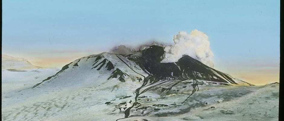
that no granitic crust exists under the floor of the Arctic Sea.Volcanology. It has never been seriously suggested that there is
much connection between the distribution and behavior of volcanoes and
either latitude or climate. Volcanoes occur in many parts of the world,
including both polar regions. The two common localities for the eruption
of volcanoes are on oceanic islands and along seismic belts, in young moun–
tain ranges, and along island arcs.The only volcano known to have been active within the Arctic Circle in
historical time is on the island of Jan Mayen, which is situated between
Greenland and the north of Norway, about 71° N., 0 8° W. The island is ✓
34 miles long and 9 miles in greatest breadth. It is essentially formed
of two volcanic peaks, of which the more northern, Beerenberg (8,350 ft.),
is the higher. In 1818, volcanic eruptions accompanied by a fall of ash
were observed on this peak.In 1947, Troelsen discovered in Peary Land, in North Greenland,
solfataras and hot spring craters which had been in eruption within the past
few years.The most important area of former volcanism in the Arctic is the North
Atlantic or Thulean igneous province of Tertiary age. This is the name given
to the volcanic rocks of common age and similar characteristic which are found
on both coasts of Greenland north of the Arctic Circle, in Iceland, the Faeroes,
and in the British Isles. Jan Mayen Island is an outlying part of the province
and the only one in which any activity survives. In East Greenland tens of
thousands of square miles are underlain by basal d t flows. There are smaller ✓
018 | Vol_I-0748
EA-I. Wilson: Geophysics
areas of lava about Disko Island on the west coast. The relation of the
minor volcanic activity of northeastern Greenland to the Thulean province
is not known.There are many volcanoes in the subarctic region of Alaska and
especially along the Aleutian Islands and the Alaska Peninsula. There are
none in the northern part of that country.Terrestrial Magnetism. Extensive surveys both on land and sea have
established the fact that the earth is a magnetized sphere whose magnetism
proceeds from within.The earth’s magnetic axis is inclined at 11½° to its axis of rotation
and passes about 750 miles from the earth’s center. This magnetic axis
intersects the earth’s surface at points known as the geomagnetic poles.
The north geomagnetic pole is situated on the west coast of Greenland,
100 miles north of Thule. Due to local irregularities, this is not the
point where the dip of the magnetic field is vertical. That property defines
the better-known magnetic poles. The North Magnetic Pole is on Prince of
Wales Island in northern Canada, in latitude 73° N., longitude 100° W. The
South Magnetic Pole is in South Victoria Land, Antarctica, in latitude
72°25′ S., longitude 155°15′ E.Curiously enough, the North Magnetic Pole of the earth would in a magnet
be called a south pole, because it attracts the north poles of other magnets.The development of our present knowledge of the earth’s magnetism is an
interesting example of the slow development of the scientific knowledge. Although
the ancients had some knowledge of natural magnets, it was the Chinese who
discovered the north-seeking compass. Introduced into Europe in a crude form,
it had been in use there for at least three centuries before the time of
019 | Vol_I-0749
EA-I. Wilson: Geophysics
Columbus. He is generally credited with the discovery that the compass did
not point to the North Star, but that the declination varied from place to
place. In 1600, Gilbert showed that the earth behaved as a magnetized
sphere, and a few years later it was observed that the declination under–
went a secular change at any one place. In 1783, Halley published a theory
of declination including the supposed position of the earth’s magnetic poles,
but his concepts were most imperfect. In 1746, the Dobbs Galley came closer
than any previous ship to what was later known to be the earth’s north magnetic
pole with a result that all the ship’s compasses ceased to point in any con–
stant direction. Ellis, who was on board, rejected the obvious explanation
on the grounds that Halley had placed the pole north of Russia.Magnetic observations were made on most arctic voyages, ideas became
clearer, and in 1831, James Clark Rose located the pole on Boothi s a Peninsula ✓
at latitude of 70°05′ N. and longitude 96°46′ W. The vicinity was not
visited again until 1904 when Amundsen considered that the position of the
pole had not moved greatly. After World War II, it became apparent, however,
that a change had occurred and the pole was located on Prince of Wales Island
by members of the staff of the Dominion Observatory. Exactly when and by what
path the change in position occurred is not known, because there were no
regular magnetic observatories nearer than College (Fairbanks) in Alaska,
Meanook (Edmonton) and Agincourt (Toronto) in Canada, and Thule in Greenland.
To remedy this ignorance of the magnetic field in the Arctic, the Dominion
Observatory established magnetic observatories at Baker Lake, District of
Keewatin, in 1946, and at Resolute Bay, Cornwallis Island, in 1948, and
conducted surveys which resulted in the issue in 1948, of the first accurate
maps of magnetic dedication in the arctic regions of the Western Hemisphere.
020 | Vol_I-0750
EA-I. Wilson: Geophysics
An unusual feature of the earth’s magnetic field near the m g a gnetic poles is —
its instability. The field is subject to large secular and diurnal variations
and to a greater number of magnetic storms than elsewhere.The c ua au se of the earth’s magnetic field is not fully understood. The —
obvious suggestion that the earth’s iron core is magnetized is almost
certainly incorrect and so are most of the numerous other suggestions which
have been advanced. At the present time, there are two chief contending
theories. One due to Blackett is that a magnetic field is a property of
rotating matter in the same way that gravity is a property of any matter.
This theory has the defect that it does not explain the large changes in
the earth’s field that occur with a period of a few hundred years. Very
recently, Bullard has suggested that there are convection currents in the
liquid iron core and that these act as a self-energizing dynamo to produce
the field. He has not completed the development of his ideas but it appears
the prob s a ble properties of the core might provide the necessary field, its —
secular changes, and its approximate con a n ection with the earth’s axis of rotation. —
BIBLIOGRAPHY
1. Daly, R.A. Strength and Structure of the Earth . N.Y., Prentice-Hall, 1940.
2. Gutenberg, Beno, and Richter, C.F. Seismicity of the Earth . N.Y., Geological
Society of America, 1941. Its Spec. Pap . no.34.3. Jeffreys, Harold. The Earth . 2d ed. N.Y., Macmillan, 1929.
4. National Research Council. Committee on Physics of the Earth. Physics of the
Earth . Washington, D.C., The Council, 1931- . The Council.
Bulletins no.77- .J. Tuzo Wilson
Arctic Aspects of Geomagnetism
Unpaginated | Vol_I-0751
EA-I. (David G. Knapp)
ARCTIC ASPECTS OF GEOMAGNETISM
CONTENTS
Page Introduction 1 The General Scheme of the Earth’s Magnetism and the
Earliest Magnetic Data in the Arctic2 Revival of Arctic Work 6 The Scoresbys, Compass Deviation and Magnetic Intensity 8 Britain Looks to the Northwest 10 The Eastern Hemisphere 14 The Physicists Take a Hand 15 The Franklin Search 17 Activity in Alaska 20 Europe and the Northeast Passage 21 The International Polar Expedition 23 Some European Leaders 26 The U.S. Coast and Geodetic Survey 28 The Expeditions Continue; Birkeland and Amundsen 29 Aircraft Expeditions 35 Canadian Government Work 36 Magnetic Observatories and the Second Polar Year 37 Recent Work in Alaska 39 General Expeditions 41 Use of the Magnetic Compass in High Latitude 43 Difficulties of Polar Magnetic Observations 44 Different Kinds of Transient Magnetic Fluctuations 47 Modern View of Geomagnetism in the Arctic 49 Present Outlook 53 Bibliography Bib. 1 - 35
Unpaginated | Vol_I-0752
EA-I. Knapp: Arctic Aspects of Geomagnetism
LIST OF FIGURES
Page Fig. 1 Relation of magnetic field to position on a
uniformly magnetized sphere6-a Fig. 2 Lines of equal magnetic total intensity for 1925,
according to Fisk55 Fig. 3 Lines of equal magnetic horizontal intensity for
1925, according to Fisk56 Fig. 4 Magnetic meridian curves for 1925, according to Fisk 57 Fig. 5 Distribution of magnetic activity, 1932-33. The
numbers on the lines denote average range of
total-intensity disturbance in gammas for 60 selected
days of considerable disturbance. (After Vestine.)58
001 | Vol_I-0753
EA-I. (David G. Knapp)
ARCTIC ASPECTS OF GEOMAGNETISM
Introduction . The magnetism of the poles of our planet has intrigued
the inquiring mind of man since the very beginnings of Western civiliza–
tion — perhaps more so than any other of the many physical conditions
characterizing the Arctic. This degree of interest excited by an abstruse
natural phenomenon is somewhat astonishing, though it has been nourished
by legends and lore going back to remote cultures and ancient times.
Nature’s magnet, the lodestone, brought forth wonder and amazement long
before men had any inkling of its directional proclivities, or of the role
it was to play in the fabrication of an intricate web of intercourse among
the peoples of the earth.The sailing master who unwittingly steered his ship too close to the
dread magnetic mountain is well known to readers of the Tales of t T he Arabian check exact name then [?]
Nights ’ . Entertainments. We are told that the nails that held the vessel
together were drawn out, putting an abrupt period to the cruise and to the
episode. This fanciful idea of a forbidden magnetic mountain or isle
lingered on through medieval times, and was still current at a time when
the use of a primitive sailing compass conferred a rising surety upon mari–
time traffic (circa A. D. 1200.) The legendary center of attraction then
assumed the guise of a faraway point on the earth’s surface (usually relegated
002 | Vol_I-0754
EA-I. Knapp: Geomagnetism
to the Orient or the Arctic) that was thought to g i o vern the compass needle — ✓
an idea that persists to this day, though clearly discredited by science.
Hand in hand with this plausible assumption went the rather esoteric fancy
that the compass drew its power from the region of the heavens surrounding
the celestial pole, if not from the pole star itself. ✓The General Scheme of the Earth’s Magnetism and the Earliest Magnetic
Data in the Arctic . To exorcise these vaporous notions with solid factual
data has been a goal of 400 years’ standing, and the end is not yet. Some
time during the fifteenth century, it came to be realized that magnetic north
differs systematically from true north by an angle which we call the magnetic
declination. This is but one of several magnetic elements, others being the
dip, the intensity, and various components of the intensity. All magnetic
elements are subject to diurnal, annual, and other variations . However, the
magnetic declination is itself often called “variation” (of the compass).
Hence, careful discrimination is needed in the use of the term “variation”.The quest for a better knowledge of the magnetic elements, particularly
the declination, has rightly carried great weight among explorers and seamen,
and this quest constitutes the “motif” for the present survey of the magnetic
work done in the Arctic.The record begins with Stephen Borough’s voyage (46) in search of the
mouth of the River Ob in 1556-57. Borough was turned back at Kara Strait.
Nevertheless, he obtained values of the magnetic de c lination at three points ✓
on the shores of the White Sea, and at three others in the vicinity of Kara
Strait. Next in the area was the indomitable William Barents, who recorded
several values of the magnetic declination beyond Kara Strait and along the
northwest coast of Novaya Zemlya, as well as at Bear Island and in
003 | Vol_I-0755
EA-I. Knapp: Geomagnetism
Hinlopen Strait, Svalbard. His data were obtained on the first and third
of his voyage s (47). ✓Meanwhile, data from a different quarter resulted from the remarkable
voyage of John Davis into Baffin Bay (48) in 1587. We have values of declina–
tion at two points, one his farthest northing near Söndre Upernivik, Greenland,
and the other in the north end of Cumberland Sound.During this period, under the stimulus of the general quickening of
maritime activity, there were published in London two books that marked
important advances in our understanding of the earth’s magnetism. Ronert
Norman in The New Attractive (1581) announced his discovery of the fact that
the north-seeking end of a suitably balanced magnet makes a definite and
(in Britain) a considerable downward angle with the horizontal. He supposed
this angle of dip to be a direct witness of focus or “point respective” that
lay deep within the earth, disparaging the idea then current of a celestial
center of attraction. William Gilbert’s treatment of this problem in the
monumental De Magnete (1600) went a step further and showed the approximately
correct relation of dip to “latitude” on a magnetized sphere, varying from
zero on an equatorial line to 90° at two polar points. With Gilbert, this
relation took the form of an empirical construction derived so as to fit
experimental data. Gilbert asserted (on what now seem scant grounds) that
the earth actually behaved like such a sphere. This image was a bold advance
for the times, and still holds favor as a fair over-all description, though
the pattern is warped and distorted to a degree undreamed of by Gilbert.Had Gilbert not died shortly after the publication of his book, he
would have received gratifying confirmation of his conjecture regarding the
dip, at the hands of more than one explorer. George Weymouth in Frobisher Bay
004 | Vol_I-0756
EA-I. Knapp: Geomagnetism
in 1602 (49), Henry Hudson in the Barents Sea in 1608 (50), and William
Baffin in Svalbard (Spitsbergen) in 1613 (51), all made dip observations
showing that in these high latitudes the dip did indeed become quite large.
These navigators also added diligently to the store of data on declination
in the North, as did several other explorers during the period 1609-1631.
Specifically, we have data for the Barents Sea by J. C. May (52); for the
Pechora River by Josias Logan (53) and William Gourdon (54); and for
Svalbard by Jonas Poole (55), Robert Fotherbye (56), and Maerten Remmertsz (57).
Baffin observed the declination frequently; we have data from all except the
third of his five voyages, including one value of 56° W. (greater than any
previously observed anywhere) at the extreme latitude of 77°30′ N. in Smith
Sound. His work provided a significant access of new data for Davis Strait.
Further data for this general area, including Hudson Bay, resulted from the
work of William Hawkridge (58), Luke Foxe (59), and Captain James (60).With the lapse of interest in a northern route to be Orient, the
growth of knowledge about magnetic conditions in the Arctic came to a halt.
No new data are recorded for nearly a century, except a few obtained by
John Wood (61) in 1676 along the coast of Novaya Zemlya. During this period
there was considerable activity in lower latitudes, reflected in the discovery
of secular change in the horizontal direction of the field (1634), the inven–
tion of isogonic charts (1641), the disquieting evidence of transient
diurnal fluctuations in the earth’s magnetic field (1685), and the publica–
tion of what was probably the first isogonic chart to be based on a compre–
hensive assemblage of data, the famous Atlantic chart of the English
Astronomer Royal, Edmond Halley (1701).
005 | Vol_I-0757
EA-I. Knapp: Geomagnetism
The writings of Kircher, Halley, and Musschenbroek show that natural
philosophers were taking an increased interest in geomagnetism as a branch
of science. Halley had grappled at an early date with the difficult problem
of the gross regional distortions that confronted Gilbert’s idealized model.
His interpretation reflects the first of repeated attempts to systematize
the phenomena by postulating secondary poles. Schüt s z (27) discusses Halley’s ✓
ideas from a more up-to-date point of view. While this particular scheme is
out of favor today, its ultimate influence as a spur to magnetic exploration
was undoubtedly strong, especially so in the Arctic. Halley also was the first
to suggest a connection between the earth’s magnetism and the aurora borealis;
this was shortly before the discovery of irregular magnetic activity, which
within a few years was claimed to be directly linked with the aurora, though
the reality of this connection remained in dispute for nearly a century.William Whiston made extensive observations at many places in England
to determine the dip and the time of oscillation of a magnetized needle.
His needle was set up to oscillate, sometimes in the magnetic meridian plane
about the line of dip, and sometimes laterally in the horizontal plane. He
arranged to have needles mounted aboard ships, and one such instrument was
sent on a voyage into the Barents Sea (62), where its time of oscillation
was observed. Whiston’s writings of 1721 and 1724 are thus the earliest
known that deal experimentally with the strength or intensity of the earth’s
magnetic field. Subsequent scattered observations, oddly enough, lent
support to the idea that the total intensity of the earth’s magnetism was
everywhere the same, a notion that prevailed for a long time. Not until
many years later was a more truthful general principle enunciated connecting
the intensity with the latitude.
006 | Vol_I-0758
EA-I. Knapp: Geomagnetism
Although there is no strict relation between latitude and magnetic
field, it is useful to know the relation which would exist if the earth
were uniformly magnetized parallel to its axis of rotation. In Figure 1,
let O be a point on the surface of such an earth. Draw OA parallel to the
axis of rotation, and of such length that it represents (on some chosen
scale) the value of the magnetic field at the Equator. Draw OB tangent to
the surface; angle AOB is then the latitude of O . Draw OB tangent to the sentence repeated Space for Fig. 1?
surface; angle AOB is then the latitude of O . Draw AB perpendicular to OB
and extend it to C , so that BC = 2 AB . Then OC represents the magnetic field
at point O . The lengths OB , BC , and OC show (on the chosen scale) the
horizontal, vertical, and total intensities, respectively; and angle BOC
is the dip. On this idealized earth, the horizontal intensity would vary
as the cosine of the latitude, whereas the dip would have a value whose
tangent is twice that of the latitude.Revival of Arctic Work . The arctic data thus far discussed have all
pertained to two circumscribed areas — one lying between Svalbard and the
Kara Sea, the other in the environs of Davis Strait. We now turn to a new
segment of the Arctic, namely that disclosed in the Kamchatka Expedition of
Captain V. I. Bering, made in 1725-30 in the interest of the Russian
Empire (64). This voyage yielded the earliest data on the declination
along the coast of Kamchatka and in Bering Strait.Closely after this venture, we come to the concerted Russian undertaking
known as the Great Northern Expedition (66), in which various teams of explorers
collaborated on a vast scale to map the arctic shore line of the Eurasian
continent from the Kara to the East Siberian Sea, while the discoveries of
Bering were extended and consolidated by himself and others, sailing as far
006a | Vol_I-0759
Relation of magnetic field to position
on a uniformly magnetized sphere.
FIGURE 1.
007 | Vol_I-0760
EA-I. Knapp: Geomagnetism
as the Gulf of Alaska. Compass data were recorded by all these parties,
the names of the observers or leaders being Skuratov, Ovtayn, Sterlegov,
and D. and K. Laptev.In the same period there were several British voyages into the upper
reaches of Hudson Bay. One which yielded new material on the declination
in that area was the expedition (67) , of Francis Smith and William Moore
in 1746-47.The expansion of European magnetic exploration by land began now to
impinge on the A a rctic Z z one at various points. We may mention in particular ✓
the work of Beliaev (68), Rumovaky (69), Pictet (70), and Mallet (71) in
the White Sea region, and of Holm (72), Anders Hellant (73), and later
Lö ew we nörn (74) on the Scandinavian Peninsula. The scope of Holm’s work ✓
extended in 1766 to Husstappen Island, near North Cape, whereas Hellant
and Löwenörn observed declination at numerous stations in arctic Sweden
between 1748 and 1786. On the far side of the arctic basin, the well-known
exploring expedition of the Russian explorer and merchant, N. Shal a urov (75), ✓
yielded significant new data for the remote Chukotsk Peninsula.A few data for points in the Barents Sea resulted from the Chichago f (76) ✓
and Rosmyslov (77) expeditions, whereas William Bayly (78) observed both
declination and dip at North Cape in 1769. For the Svalbard area we have
data credited to Claessen, given in A. R. Martin’s diary of his 1758
voyage (79), as well as the dip values resulting from the J. C. Phipps expedition (80) of 1773. Some data resulted from a hydrographic line missing cf. original p. 8
survey (81) by the Russian Navy in 1779, in the Norwegian Sea, and from the
work of Abrosimov and Ivanov in the White Sea area in 1800 (82).In the Bering Straig region, the definitive explorations of Captain
James Cook (1778-79) yielded further data (83) covering stretches of the
008 | Vol_I-0761
EA-I. Knapp: Geomagnetism
Pacific and arctic coasts of both Alaska and the Asiatic mainland. Special
attention was given to the ast r onomical and magnetic work which was brought ✓
to new levels of accuracy in that the recently developed and improved
sextant was used for obtaining the sun’s altitude. The magnetic program
included both declination and dip. Subsequent data are due to work under
Russian auspices in this vicinity by Sarychev and Billings (84), by Gilev
(85), and by Kotzebue (86). Somewhat to the westward, the surveys made in
1809-10 by the exiled M. M. Hedenström (87) in the region of the New Siberian
Islands provided new and valued data for those islands and for their mainland
approaches.The Scoresbys, Compass Deviation and Magnetic Intensity. With the open–
ing of the nineteenth century we come first to the work of two redoubtable
Scotsmen, the arctic navigators William Scoresby, Senior and Junior (88).
Not only did their many successful whaling voyages reveal hitherto unknown
regions (e.g., much of the remaining east coast of Greenland) but their
lively interest in scientific work and their keen discernment had lasting
effects on the diverse topics touched by their many inquiries. William
Scoresby, Junior, took as one of his chief interests the magnetism of iron
and steel and the deviation of the compass resulting from the magnetism of
a ship. He conducted some of his experiments on these matters in 1822 while
the Baffin was beset in the ice at latitude 79° N., discovering a new and
more effective technique of utilizing the earth’s magnetism to induce
polarity in steel rods.The challenging task of reducing to rational law the deviation and
compensation of the compass was to attract some of the ablest scientific
minds of that day and the next before it found full elucidation. A start
009 | Vol_I-0762
EA-I. Knapp: Geomagnetism
had been made by William Wales, the astronomer on Cook’s second voyage,
and important advances are due to Matthew Flinders, Peter Barlow, and
other contemporaries of the younger Scoresby. As Scoresby himself was
well aware, these effects may impose stringent limitations upon navigation
and hydrography in the Arctic and elsewhere. They are particularly serious
if a craft goes into regions where the ratio of the horizontal to the
vertical intensity becomes very small, as it does in much of Arctic America.
Scoresby’s data on the magnetic declination have special significance and
validity, for he remarks (89): “All the magnetic observations, whether
for determining the bearing of the land, or the azimuth of the sun, were
taken at the mast-head, because this was the only part of the ship where
compass-bearings could be relied upon. In every other part of the ship,
indeed, that could be conveniently resorted to, there was so much ‘local–
attraction’ or ‘ deviation,’ that observations taken therein, with the ✓
magnetic needle, were useless.” On some of his voyages vibrations of a
dip needle were taken in order to determine the total intensity.This period was marked by an increasing awareness of the fact that
the intensity of the earth’s magnetic field is one of the elements whose
distribution must be charted for a fuller understanding of the whole
phenomenon. The measurements made by Paul de Lamanon as a participant
in the doom-ridden expedition (90) of La P e é rouse (1785-88) and mentioned ✓ accent
by him in a communication to the Paris Academy of Sciences before disaster
overtook the expedition, reinforced by the observations made by Alexander
von Humboldt on his travels in South America (1798-1803), had forced a
final recognition that the intensity was not everywhere constant but
instead underwent a twofold increase from equator to pole.
010 | Vol_I-0763
EA-I. Knapp: Geomagnetism
Several P p hilosophers were again seeking to systematize and generalize ✓
the accrued data on the declination and its secular change. The most
penetrating and fruitful of these studies was that of the Swedish astronomer
Christopher Hansteen, who published in 1819 his celebrated work Magnetismus
der Erde (12). This book assembled all the magnetic data to which the
author had access, and presented his refined and elaborated hypothesis of
two distinct centers of convergence of the magnetic pattern in each polar
zone. This proposal depended, of course, on the general trends of the
magnetic lines that could be perceived in high latitudes, rather than on
direct observation of the magnetic poles.Britain Looks to the Northwest . Obviously, the efforts of Hansteen
and his contemporaries were sorely hampered by the gap of Arctic America.
Whaling craft now frequented Baffin Bay, and there had been a voyage led
by Richard Pickersgill (91) in 1776 that yielded data for seven points in
Davis Strait. But the area to the north and west was an almost complete void
on the map, stretching over a full hundred degrees of longitude, prior to
the great series of British expeditions that was inaugurated in 1818 under
the encouragement of scoresby’s arctic achievements. Though not a success
in the popular view, the dual expedition of that year yielded highly valued
new magnetic data, the work of James Clark Ross and Edward Sabine in Baffin
Bay (92) and of John Franklin and Alexander Fisher in the Svalbard area (93).
The observations of Ross and Sabine were made on the ice of Melville Bay,
well clear of the effects of the ship’s magnetism, and they included dip
and intensity measurements as well as declination.After this beginning, the intricacies of what we know today as the
Parry Archipelago began to give way before a vigorous renewal of the quest
011 | Vol_I-0764
EA-I. Knapp: Geomagnetism
for the Northwest Passage; and each new exploration brought forth new
magnetic data of a gradually expanding scale and scope that reflected the
growing urgency and significance attached to this phase of arctic explora–
tion by the great nineteenth-century physicists. During William Edward
Parry’s memorable voyage through Lancaster Sound and into Barrow Strait
in 1819-20 (94), Sabine obtained data at six stations in the vicinity of
Melville Island, and he conducted at Winter Harbour protracted observations
of the time variations, something that had not previously been attempted
in polar regions. This arduous program, carried out on the very first
voyage to go across the intriguing zone of southward streaming of the
magnetic lines, was an earnest of the subsequent endeavors by which Sabine
was to advance so greatly the understanding of geomagnetic phenomena. It
is also worth noting that Sabine, being already acquainted with Flinders’
earlier experiments on compass deviation, seized his chance during this
voyage to test and refine the conclusions of Flinders by means of experiments
under arctic conditions.Competent work was done on Parry’s two subsequent voyages as well, with
the assistance in 1821-23 of Fisher and James Ross and in 1824-25 o r f Ross, ✓
Henry Foster, and F. R. M. Crozier — the same Crozier who was later to
perish with the last Franklin expedition. On the second voyage (95),
contrasting curves of daily variation were obtained at the two wintering
stations in the southwest and northwest corners of Foxe Basin. Parry’s
third voyage (96) yielded new data for Prince Regent Inlet, including
extended readings at Port Bowen by means of variation instruments. The
expedition’s proximity to the magnetic polar locality was indicated by the
determinations of horizontal intensity, the least thus far attained.
012 | Vol_I-0765
EA-I. Knapp: Geomagnetism
A large pivoted needle constructed especially for reading the daily variation
was set up, but the directing force upon it was too weak to overcome the
slight friction of the pivot. It was necessary to suspend the needle by
means of a silk fiber before it would respond. The same difficulty made
the ship’s compass useless and was a chief factor in Parry’s failure to
complete the exploration of the shores opposite the Brodeur Peninsula, as
he had hoped to do on this third voyage. There had at long last been reached
the zone that most nearly corresponded with the ominous magnetic isle of
legend and fancy. Strangely enough, twenty-three years later this very
locality was to witness the undoing of a great company of intrepid men,
albeit the compass problem was not so great a difficulty as the overwhelming
obstacle placed athwart the Northwest Passage by a jealous and impassive
Neptuns, in the form of prodigious quantities of ice pushing relentlessly
southward from Viscount Melville Sound.This third voyage of Parry’s was also the occasion for some preliminary
daily variation readings (97) made by Foster during a brief stay in the
Whale Fish Islands (Disko Bay), not far from the present Godhavn, where
a magnetic observatory is now in operation. F. W. Beechey’s cooperating
expedition in the Blossom , which is credited with the discovery of Point
Barrow in 1826, was likewise a source of magnetic results, the work of
Beechey, Edward Belcher, J. Wainwright, and J. Wolfe (98). Simultaneously,
a voyage of the French whaling captain L.-A. Gu e é don (99) added to the store accent
of data for the Baffin Bay area.Meanwhile, the quest went forward by land. The Franklin expeditions
of 1819-22 and 1825-28, which at a cost of seven lives mapped two great
rivers and most of the arctic coast of the continent, yielded magnetic data
013 | Vol_I-0766
EA-I. Knapp: Geomagnetism
along with the other results. The magnetic work of the earlier journey (100)
was divided amon t g three men — Franklin, George Back, and the ill-fated —
Robert Hood. On the second expedition (101), E. N. Kendall and Dr. John
Richardson shared this work with Franklin and Back. These first explora–
tions in the Canadian Arctic reached a fitting climax in 1829-33 with the
privately sponsored expedition of John and James C. Ross (102). This out–
standing enterprise was prolific in both geographical and geophysical results,
but its chief contribution was probably the series of dip observations made
in the magnetic polar area, which James C. Ross found to be centered on the
west coast of the Boothia Peninsula, nicely countering the C c elebrated —
achievement of L. I. Duperrey, who in 1822-25 had traced the magnetic
equator across two oceans.Anxiety over the delayed return of the Rosses led to the organization
under George Back of a relief expedition (105) which in 1833-35 explored
the Great Fish River (since renamed the Back River). Back also led an
expedition (107) to Repulse Bay in the Terror in 1836-37. On both occasions
he secured valuable magnetic data supplementing those of Ross and his
observations on the coincidence of auroral and magnetic activity, subse–
quently confirmed by Lottin and Bravais at Bossekop, helped to place this
remarkable connection beyond dispute. James Ross was engaged in the
magnetic survey of England for a time after his return from the Arctic and
prior to his crowning antarctic explorations. He also traveled in the
summer of 1836 to Davis Strait and Baffin Bay, observing the dip at two
points on the Greenland coast. Further magnetic data for the arctic
seaboard region of mainland Canada accrued from the explorations of the
intrepid Thomas Simpson (108 ) and the remarkable John Rae (109), both men —
of the Hudson’s Bay Company.
014 | Vol_I-0767
EA-I. Knapp: Geomagnetism
The Eastern Hemisphere . During the same period (1820-40), magnetic
work was being actively pursued in other arctic sectors as well. Frederick
von Lütke’s exploration (110) of the west coast of Novaya Zemlya in 1821-24
yielded new compass data for that area. In 1823, the work of the Clavering–
Sabine pendulum expedition (111) included Sabine’s measurements of dip and
total intensity at each of his four stations — Trondheim, Hammerfest, a
Norway Island (Svalbard) station, and Pendulum Island, high on the east
coast of Greenland. Further data for 18 points in and north of the Svalbard
Archipelago are credited to Parry, Foster, and Ross as a result of the
poleward thrust (112) led by Parry in 1827. In the same year, the Danish
geologist B. M. Keilhau (113) obtained numerous values of dip and intensity
along the Norwegian arctic coast and in Svalbard. Other observers contri–
buted to the magnetic knowledge of Svalbard and the east coast of Greenland,
namely, W. A. Graah (115) in 1829, the ill-starred J. de Blosseville (116)
in 1833, and Victor Lottin as a participant in the search expedition (117)
for Blosseville in 1835-36. Lottin, M. A. Bravais, C. B. Liljehoek, and
other members of the Recherche expedition of 1838-40, led by Paul Gaimard
(118), obtained further magnetic and auroral data in the North Cape area,
including an important series of variation readings at Bossekop occupying
several months. Magnetic data were also obtained by P. K. Pakhtusov in two
expeditions to explore Novaya Zemlya, in 1832-35 (119; 120), and also by
Moiseev and Ziwolka (121).Magnetic explorations in the Siberian Arctic were also continuing.
Especially fruitful were those of Ferdinand P. von Wrangel (122) and P. F. Anjou ✓
(123), with P. T. Kozhmin, including in their scope seven stations in the
New Siberian Islands. Hansteen, desiring to test his hypothesis of a
015 | Vol_I-0768
EA-I. Knapp: Geomagnetism
secondary Siberian focus of intensity (which had been conjectured from
the pattern of declination), made a journey through Siberia with Christian
d D ue and Adolph e Erman, skirting the Arctic Circle. Extensive meassurements ✓ ✓
made at many points bore out the hypothesis. This was in 1828; Erman con–
tinued eastward across the Pacific and around the globe (124). Another
round-the-world voyage was Lütke’s in the Seniavin e in 1826-29, during ✓
which data were obtained for the Bering Strait area and for Sitka (125).
Further data for the Siberian Arctic are due to the land explorations (126)
of A. T. von Middendorf in 1843-44. Veinberg (40) credits data for the
north of Europe during this period to a number of observers.The Physicists Take a Hand . An interesting result of the earlier
arctic work of Sabine and others was his deduction that the point of maximum
total intensity was not, as had been supposed, coincident with the dip pole
spotted by Ross but lay a long way to the south of it. Sabine was instru–
mental in arranging for a series of measurements to be made in the interior
of Canada for tracing out this focus of maximum intensity. The work was
done in 1843-44 by J. H. Lefroy (127). Sabine found his proposition amply
confirmed, just as had Hansteen with respect to the corresponding Siberian
focus. During Lefroy’s survey he made extended observations on the daily
variation at Fort Chipewyan on Lake Athabaska, and at Fort Simpson (136).While Poisson and Airy, and later Archibald Smith, were delving into
the mathematical basis of compass deviation and the magnetism of ships, there
was a great upsurge of experimentation and discovery in the newly opening
field of electromagnetism. Basic laws began to emerge in rapid succession.
It became clear that the earth’s magnetic field afforded a convenient working
medium on which to base the measurements of electric current, but the
016 | Vol_I-0769
EA-I. Knapp: Geomagnetism
measurement of the magnetic field itself was in an unsatisfactory state,
because all intensity readings were directly dependent on the strength of
magnetization of the needles used, a shifting and uncertain factor. This
handicap p was brilliantly dispelled by the work of Karl Friedrich Gaus s of ✓ ✓
Göttingen. He developed, along the lines of suggestions by Poisson, a
method of measuring both the horizontal intensity of the earth’s field and
the magnetic moment of the magnet, by a coordinated experiment involving
oscillations and deflections with a single instrument. In almost every
respect the Gaussian technique was far superior to the older methods, and
it placed intensity measurement on a uniform basis such that henceforth
the determinations of different observers, made apart, could be directly
compared and coordinated.Gauss likewise brought a fresh approach to the problem of generalizing
the distribution of the earth’s field. He concluded that all studies which
sought to interpret the earth’s magnetism in terms of supposed dominant and
secondary poles suffered an intolerable lack of generality. In 1838 he
published the celebrated Allgemeine Theorie des Erdmagnetismus , embracing his
versatile invention of spherical harmonic analysis. The distribution of a
function over any spherical body could now be represented mathematically
with any desired precision, simply by utilizing a sufficient number of terms
in the infinite series that comprised his formulas.Gauss was one of the first to perceive the importance of making continuous
observations of daily variation and other transient phenomena of the earth’s
magnetism, particularly in regard to a host of minor features that had not
been discernible in the earlier, grosser measurements. He shares with
Weber, Humbol td dt , and Sabine the credit for promoting the establishment of ✓
magnetic observatories at widely separated points.
017 | Vol_I-0770
EA-I. Knapp: Geomagnetism
These achievements of Gauss and his contemporaries lifted all magnetic
explorations to new levels of accuracy and significance, and at the same
time they underscored sharply the deficiencies of existing surveys and
especially the need for more and better data in the Arctic.The Franklin Search. Following the work of Ross, Back, et al . , in the ✓
1830’s, there was a brief pause in the exploration of the Parry Archipelago.
The calm ended abruptly with the epi d c final expedition of Sir John Franklin, ✓
trapped in the ice that battered his ships inexorably against the shoals of
Victoria Strait, after a smooth passage down Peel Sound and past the magnetic
pole toward King William Island. This expedition was equipped for an
intensive program of hourly magnetic readings to be made at any wintering
stations which it might take up; doubtless such a program was fulfilled
during the first winter at Beechey Island, and it can be assumed that magnetic
observations were obtained in other areas as well. Whatever scientific
records accrued, however, were lost without trace, presumably being destroyed
with the ships. The nest three decades, from 1848 to 1879, witnessed a fever
of activity in this area devoted first to the vain hope of releasing the 129
men or any survivors, then to the search for traces of their desperate final
wanderings, and at last to the development of the many new discoveries cast
up during the search.Like the Franklin group itself, many of the expeditions that conducted
the Franklin search were well equipped with magnetic instruments suited to
the region of near-vertical magnetic flux. Others contributed less accurate
determinations made with ships’ compasses. The schedule given below shows
the areas in which magnetic data of one sort or another were obtained by
the various Franklin search expeditions or subexpeditions, together with the
names of the observers.
018 | Vol_I-0771
EA-I. Knapp: Geomagnetism
Group I. Pacific Approach
Moore cruise of 1848-49, ship Plover (128); Bering Sea; data by T. E. Moore.
Kellett cruise of 1848-49, ship Herald (129); Bering and Chuckchi e Seas; ✓
data by H. Kellett.Kellett cruise of 1850, ship Herald (130 ) ; Bering Sea and Kotzebue Sound; ✓
data by H. Kellett.Maguire cruise of 1852-54, ship Plover (131); observations supervised by
Rochfort Maguire at Point Barrow during two winters, totaling 17 months
of hourly declination readings.Collinson expedition of 1850-54, ship Enterprise (133); Bering and Beaufort
Seas, Coronation Gulf, and Victoria Strait; data by Richard Collinson.McClure cruise of 1850-54, ship Investigator (134); Prince of Wales and
M’Clure Straits; data by R. J. Le M. M’Clure.Group II. Atlantic Approach
Ross-Bird expedition of 1848-49, ships Enterprise and Investigator (135);
Lancaster Sound; data by J. C. Ross, W. E. J. Browne, and Fred Robinson.Richardson-Rae expedition of 1848-49, by land (136); Fort Confidence, and
vicinity of Dolphin and Union Strait; data by John Richardson and John Rae.Austin expedition of 1850-51, ships Resolute and Assistan t ce (137); Peel ✓
Sound; data by Robert C. Allen and W. E. Ommanney.Kennedy expedition of 1851-52, ship Prince Albert (138); environs of
Somerset Island; data by William Kennedy and J. R. Bellot.Inglefield expedition of 1852, ship Isabel (139); Hound Islands (Disko Bay);
data by E. A. Inglefield.Belcher expedition of 1852-53, ships Resolute and Assistance (140);
Barrow Strait and Wellington Channel; data by J. N. Allard, R. C.
Allen, E. Belcher, R. V. Hamilton, H. Kellett, G. F. M’Dougall, and Richard Roche.
019 | Vol_I-0772
EA-I. Knapp: Geomagnetism
Inglefield expedition of 1853, ship Phoenix (141); Melville Bay and Beechey
Island; data by J. R. Bellot, who lost his life on this cruise.Grinnell-Kane expedition of 1853-55, ship Advance (142); Kane Basin; data
by E. K. Kane and August Sonntag, including hourly values of the
declination at an observatory on the Greenland coast above Etah.M’Clintock expedition of 1857-59, ship Fox (143); data by F. L. M c ’ Clintock, ✓
including ice and shore observations in Baffin Bay and on King William
Island and nearby points, and an important series of hourly readings
at Port Kennedy, the wintering station near Bellot Strait.Hayes expedition of 1860-61, ship United States (144); shore area centered
at Umanak Fjord, Greenland, also Ellesmere Island; daily variation
readings at Port Foulke, the wintering station near Cape Alexander,
Greenland; absolute observations included three elements; data by August
Sonntag, M. G. Radcliff e , and S. J. McCormick. ✓Hall expedition of 1864-69, by land (145); Melville Peninsula to King
William Island; data by Charles Francis Hall.Hall expedition of 1870-73, ship Polaris (146); North Greenland coast,
especially Hall Land and Hall Basin; data by Emil Bessels, Richard W.B.
Bryan, and F. Meyer. Beyond the above data, protracted hourly readings
were made in winter quarters but could not be saved.Nares expedition of 1875-76, ships Alert and Discovery (147); shore stations
facing, and sledge journey into the Lincoln Sea; data by A. H. Markham,
Pelham Aldrich, R. H. Archer, and L. A. Beaumont. Instructive notes and
magnetic charts drawn up for the guidance of this expedition have been
published (17). They include valuable summaries of the magnetic results
produced by earlier expeditions.
020 | Vol_I-0773
EA-I. Knapp: Geomagnetism
Activity in Alaska . Under the stimulus provided by the investigations
of Gauss, Humboldt, and Sabine, and as a direct result of the influence of
these and other eminent scientists of the time, there was in the 1840’s
an active program by which several countries established magnetic observa–
tories to learn more about the transient fluctuations of the earth’s
magnetism. In 1842 the Russian authorities set up one of their observatories
on Japonski Island near Sitka. (There had been in the period 1832-35 a program
of magnetic work at this post under Wrangel (125a)). It functioned continuously
for eleven years, and again from 1857 to 1864, providing the earliest know–
ledge of the daily variation that prevailed in this quarter of the globe (148).Elsewhere throughout Alaskan shores and waters, the record of Russian
magnetic data comprises those obtained by various exploreres and travelers
already recounted in this discussion — Bering, Sarychev, Billings, Gilev,
Kotzebue, and Lütke. There had been some magnetic work in the Bering Sea
area by John Rodgers of the Vincennes during the North Pacific Exploring
Expedition of 1855 (149). With the transfer of sovereignty from Russia to
the United States in 1867, the exploration and survey of the coasts of Alaska
became the responsibility of the U.S. Coast and Geodetic Survey. In that
year a reconnaisance by the party of G. F. Davidson (150) marked the
inception of this formidable task. A. T. Mosman of Davidson’s party made
magnetic observations at the Sitka observatory (which was still operating
as a meteorological station). He also observed on Kodiak Island, and at
Dutch Harbor in the Aleutians. Two years later, Davidson obtained new
data during an eclipse expedition (151) to Kohklux (Elukwan), near Skagway.This beginning was vigorously follo w ed up by W. H. Dall and Marcus Baker, ✓
who in 1873, 1874, and 1880 made observations (152) extending throughout the
021 | Vol_I-0774
EA-I. Knapp: Geomagnetism
Aleutian Islands and up the coast beyond Bering Strait to Point Barrow,
where Maguire of the Plover had spent two winters during the Franklin
search. The 1880 work was done on a storm-wracked cruise of the steamer
Yukon , which narrowly escaped destruction. This cruise yielded large
corrections to the previously accepted magnetic declinations and to the
longitudes as well, and led to the production of the first isogonic chart
of the territory having a valid observational foundation. Some of the data
in southeast Alaska were obtained during a boat journey from Sitka to the
Chilkat River. Some data for the arctic coast between the Firth River
and Kotzebue Sound were obtained in 1889 by C. H. Stockton, a naval officer
of the U.S.S. Thetis (152 a ). ✓Europe and the Northeast Passage . With British and American talents
engaged in the Franklin search and cognate explorations, the interest of other
nations pressed developments in the European sector of the Arctic. Several
magnetic stations by K. Chydenius were included in the work of the
Nordenskiöld (153) expedition of 1861 along the northern coast of West
Spitsbergen. The Nordenskiöld expedition of 1868 in the Sophie (154)
was likewise productive of magnetic data for this area, the work of K. S.
Lemström and several other members of the expedition. The first German
North Polar Expedition, led by K. Koldewey (155), visited the same locality
in 1868 and brought back declination values for 50 points along the track
of the Germania . The Second German North Polar Expedition of Koldewey and
Hegemann (1 65 56 ) yielded data by C. N. J. Börgen and Ralph Copeland for ✓ cf. orig. p. 27
Sabine Island and a nearby part of the east coast of Greenland. This was
the first such expedition to make use of an earth inductor or dynamoelectric
instrument in the measurement of dip.
022 | Vol_I-0775
EA-I. Knapp: Geomagneti c sm ✓
Some magnetic data accrued during hydrographic surveys of Novaya Zemlya
about 1870, such as those of E. Carlsen and Edward H. Johannesen (157).
The magnetic survey of northern Europe included a river, lake, and ocean
tour made in 1870 by Ivan Belavenetz in connection with the Varyag expe–
dition of Grand Duke Alexis (158). An important advance was accomplished
by the Russian and Siberian survey made in 1873-74 by F. F. Miller; some
64 stations were occupied, many of them in the arctic zone (159).The Austro-Hungarian expedition of 1872-74, le t d by Weyprecht and ✓
Payer (160), was equipped with the latest type of instruments for observing
the fluctuations of the magnetic elements. These variometers, of Lamont’s
design, enabled three elements to be read in rapid succession, using small
magnets having relatively short periods of oscillation. This markedly
enhanced the significance of the results, in view of the almost continual
motion of the magnets characteristic of such observations in the Arctic.
This apparatus was set up in a snow hut soon after the Tegetthoff , in its
its erratic northward drift, had come to rest at Wilczek Island in the Franz
Jose ph f Archipelago. The readings were made on a notably intensive schedule ✓
for more than three months, and were among the first to provide virtually
simultaneous values of three magnetic elements, being also the earliest
magnetic data of any sort for that remote region. The data are credited
to Karl Weyprecht, Gustav Brosch, and Ed. Orel. They include absolute
values both there and at various points traversed during the northward drift.The Swedish Polar Expedition of 1872-73 under Nordenskiöld (161)
produced another important body of variation data, applying in this case
to the winter station at Mossel Bay, near the northern tip of West Spitsbergen.
The observers were August Wijkander and Louis Palander. New data for Norwegian
023 | Vol_I-0776
EA-I. Knapp: Geomagneti c sm ✓
coastal ports as far as Vardö, and sea observations in the Norwegian and
Greenland Seas, resulted from the North Atlantic hydrographic cruises (162)
of the Norwegian vessel Vöringen during 1876, 1877, and 1878. The magnetic
data are due to C. Will s e . The magnetic elements were observed by H. M. ✓
Speelman, L. B. Koolemans Beynen, L. A. H. Lamie, C. J. G. de Booij, and
J. H. Calmeijer in the cruises of the William Barents in 1878-81 to Bear
Island and Amsterdam Island (Svalbard) and Novaya Zemlya (162a). Hydro–
graphic operations in the Bering Strait area by M. S. Onatsevich (163)
likewise yielded magnetic data during this period.The celebrated voyage of the Vega in 1878-80 under Palander and
Nordenskiöld (164), the first to achieve the Northeast Passage, yielded
magnetic data for many points along the route, including a three-month
series of variation data for Pitleka i , the wintering station where the ✓
expedition was detained when just short of Bering Strait. The observer
was A. P. Hovgaard. The American expedition of George W. De Long in the
Jeannette (165) in 1879-82, despite its tragic outcome, yielded new
magnetic data along with its valuable geographic discoveries in the East
Siberian Sea.Data for Wrangel Island were obtained in 1881 by C.L. Hooper of
the Corwin (166) and by R. M. Berry and G. R. Putnam of the Rodgers (167),
a relief ship sent to search for De Long.The International Polar Expedition . The Franklin search expeditions
and several European expeditions had, by 1875, contributed a number of
series of variation observations — that is, detailed readings on a pro–
tracted hourly schedule, or some comparable means of keeping track of the
transient fluctuations. There were enough data of this sort to demonstrate
024 | Vol_I-0777
EA-I. Knapp: Geomagneti c sm ✓
the challenging complexity of the daily variation pattern in the Arctic,
and the extreme difficulty of separating the fortuitous fluctuations from
those which might be expected to show regularity from day to day and from
year to year. The prevalence of irregular disturbances in high latitudes
was recognized, though it was not clear just how they were interrelated in
different sectors.The factors that retarded progress in these topics were clearly dis–
cerned by Karl Weyprecht, the Austrian naval officer, who supervised the
scientific work and the land explorations of the Tegetthoff expedition.
Though he secured some valued results, yet he was dissatisfied with what
any isolated expedition might hope to achieve. He argued cogently that
concerted efforts in all sectors of the Arctic would accomplish more in
a scientific sense than would any number of consecutive, independent
expeditions. His proposals met with the ready concurrence of meteorolo–
gists and magneticians of other nations, and culminated in the establishment
of the International Polar Commission to promote a full-year program of
intensive arctic investigation, with meteorology and geomagnetism as the
chief topics of study. The participating nations undertook to send expe–
ditions to different parts of the Arctic, while the Commission secured
agreement on uniform minimum standards for the observing program, and
supervised the publication of the results.The 13-month period beginning on August 1, 1882, was agreed upon for
the occupation of all the stations and was designated as the “International
Polar Year.” Greely’s Polar Handbook (11), Chapter 16, gives a good account
of the twelve expeditions, their original objectives, and their immediate
accomplishments. Neumayer (180) gives a somewhat more extended account.
025 | Vol_I-0778
EA-I. Knapp: Geomagneti c sm ✓
Summarized results in a form useful for reducing the data of subsequent
expeditions to mean of day have appeared several times, for example, in
an account by Fleming (218). Table I will serve for tracing the published
output of each group and it also gives a few details of general interest.TABLE I. Participating
countryLeader Locality
of workStation
occupiedAustria-Hungary E. von Wohlgemuth Norwegian Sea Jan Mayen (168) Denmark A. F. W. Paulsen SW. Greenland Godthaab (169) Germany W. Giese Cumberland Sound,
Baffin IslandKingua Fjord (170) United States A. W. Greely NE. Ellesmere Island Fort Conger (171) Great Britain H. P. Dawson Great Slave Lake Fort Rae (172) United States P. H. Ray Point Barrow Ooglaamie (173) Russia N. Jürgens Lena Delta Sagastyr (174) Netherlands M. Snellen Kara Sea (175) — ✓ Russia K. P. Andrejeff Novaya Zemlya Karmakuly Bay (176) Finland K. S. Lemström Arctic Finland Sodankylä and
Kultala (177)Norway A. S. Steen North Cape Bossekop (178) Sweden N. Ekholm Ice Fjord, Svalbard Cape Thordsen (179)
The scientific gains that accrued from the International Polar Year
program in terrestrial magnetism were important and lasting. It was possible
at last to correlate the fluctuations occurring simultaneously in different
parts of the Arctic, and to work out in some degree the patterns which governed
them, although the coverage was not sufficient to develop the details of the
026 | Vol_I-0779
EA-I. Knapp: Geomagneti c sm —
patterns. One Two such stud y ies were though was made respectively , by G. Lüdeling of the Potsdam Observatory
(181) . and by H. van Bemmelen of the Netherlands (181a).Though the International Polar Expedition as a whole was not primarily
devoted to geographical exploration, some of the separate units did carry
out important sledging trips, one of which (based at Fort Conger) reached
a higher latitude than had ever before been attained. Through some mute
conspiracy of error and misfortune, the Greely expedition was brought to
disaster in its retreat from the Arctic. Nevertheless, the seven survivors
managed to preserve the priceless records of the scientific work. Mention
should also be made of some scattered magnetic observations (171a) made in
Baffin Bay by officers of four vessels that collaborated in the relief of
the Greely expedition in 1884 — F. H. Crosby of the Bear , U. Sebres of the
Thetis , E. S. Prince of the Yantic , and C. J. Badger of the Alert .While not simultaneous with the international program, a somewhat
similar expedition under A. R. Gordon conducted observations for a year
at Stupart Bay Station on Hudson Strait, in continuation of the Fort Rae
work and using the same instruments (16).Some European Leaders . The thorough Danish explorations of the shores
and mountains of Greenland are well reported in the many volumes of
Meddelelser on Grönland . Magnetic work has not been neglected in these
surveys. To illustrate the scope of the task, a few examples will be given.
Steenstrup and Hammer determined the coordinates and the declination at
about 80 stations in the vicinity of Umanak Fjord in 1878-80 (182).
G. Holm’s explorations in 1884-85 yielded protracted declination data at
the headquarters (Nanortalik) west of Cape Farewell (182a). Farther to
the north, F. Petersen investigated the vicinity of Egedesminde, Disko
Bay (183), in 1895-96.
027 | Vol_I-0780
EA-I. Knapp: Geomagneti c sm —
Data for Jan Mayen and Spitsbergen were obtained by A. Exelmans and
others on the voyage of La Manche in 1892 (184).One of the benefits of the Polar Year work was to impel broader
recognition of the magnitude and importance attached to the task of obtain–
ing intensive magnetic data on arctic expeditions generally. Extended
series of variation data became the rule. Thus, C. H. Ryder made extensive
observations in 1891-92 on the eastern coast of Greenland, at Scoresby
Sound (185) not far from Sabine’s Pendulum Island, while another series of
data were obtained by H. Stade of the Greenland expedition of 1891-93, at
Umanak Fjord on the west coast (186). At the same time, magnetic surveys
in the regional sense were not neglected. A contribution to the magnetic
survey of Siberia was made by E. Stelling in 1888 (187), while E. Shileiko,
as a participant in E. von Toll’s expedition of 1893, occupied 37 stations
in a region bordering on the Laptev Sea — nine of them in the New Siberian
Islands (245).With respect to territorial coverage, one of the most significant and
valuable contributions to arctic geomagnetism was that of the celebrated
Nansen drift expedition of 1893-96, when the Fram was deliberately pushed
into the ice near the New Siberian Islands and carried right across the polar
sea, traversing a region never before approached (188); Lieutenant Scott-Hansen
conducted the magnetic work with unflagging zeal throughout the long period
of drift. Two circumstances conferred special significance on the work —
first, the observations were made on the ice, well clear of the influence of
the ship, and second, the path of drift lay over the very deep water of the
inner Arctic, entirely beyond the continental shelf and hence largely immune
to the intensive microstructure of the earth’s magnetism that so often tends
028 | Vol_I-0781
EA-I. Knapp: Geomagneti c sm —
to confuse and obscure the general distribution. Thus, the westward track
crossed the meridian of Franz Josef Land about 300 miles to the north of that
archipelago, at more than 85° N. latitude.The U.S. Coast and Geodetic Survey . Following the acquisition of Alaska
by the United States, there had been an expansion of government mapping
activities and related functions, not only in Alaska but in other circum–
polar and outlying areas as well. In due course, the magnetic duties of
the U.S. Coast and Geodetic Survey partook of this activity. In the interior
of Alaska, important work was done along the Yukon and Porcupine rivers in
the period 1889-91. A station called Camp Colonna, on the latter stream near
the Canadian boundary, was the site of a strenuous program of magnetic work
by J. H. Turner and H. M. W. Edmonds, including a 24-hour series of readings
of declination spaced five minutes apart and repeated once a week for nearly
seven months (189). With J. E. McGrath, this group also obtained extended
data at Camp Davidson on the Yukon, and made isolated determinations at two
stations on the Firth River and finally at St. Michael and at Dutch Harbor
(190). During 1892-94, McGrath, Turner, and others observed at the repeat
stations of Sitka and Port Mulgrave, and at many coastal points distributed
throughout southeast Alaska (191). One more station was contributed by
Harry Fielding Reid, who in 1890 led an e s x pedition to Glacier Bay (192). ✓Owen B. French and George R. Putnam of the Coast and Geodetic Survey
were detailed to participate, respectively, in the Wellman expedition to
Svalbard in 1894 and in A. E. Burton’s division of the Sixth Peary
Expedition to Smith Sound in 1896. French observed declination on Danes
Island and at four stations along the north coast of Northeast Land (194),
whereas Putnam made complete magnetic observations at eight stations
029 | Vol_I-0782
EA-I. Knapp: Geomagnetism
distributed between Halifax, Nova Scotia, and Umanak, on Baffin Bay (195).
Putnam, who in 1881 had accompanied Berry to Wrangel Island, revisited
the Bering Sea area in 1897 and made an examination of local irregularity
in the Pribilof Islands (196).These activities led up to the establishment in 1901-1902 of the five
permanent magnetic observatories of the Coast and Geodetic Survey, utilizing
the latest developments in technique and instrumentation (197). One of
these observatories was set up at Sitka, near the old Russian blockhouse.
This is today perhaps the oldest of all magnetic observatories situated
in high-latitude outposts. From its inception the Sitka observatory employed
photographic recording in preference to the tedious eye-reading procedures
so long practiced. (Continuous photographic recording had been in use at
central observatories for many years, but the photographic processing had
presented formidable obstacles to remote field use until suitable actinic
materials were generally available.) The Sitka observatory was erected and
for several years maintained by H. M. W. Edmonds, who had previously done
magnetic work by the old method on the Porcupine River, as noted above.The Expeditions Continue; Birkeland and Amundsen . The expedition (198)
led by Otto Sverdrup in the Fram in 1898-1902 was provided with the same
instruments earlier used by Scott-Hansen in the ice drift of the Fram . The
magnetic elements were determined several times at each of the four wintering
stations, although the intruments did not prove to be so well adapted to the
actual region of Sverdrup’s work in Smith and Jones sounds as they would have
been on the projected cruise round the north coast of Greenland. Because of
the reduced horizontal intensity encountered in Jones Sound, it was found
necessary to make a special long deflection bar so that the customary deflec–
tions at two distances might be obtained. The observers were V. Baumann and
G. Isachsen.
030 | Vol_I-0783
EA-I. Knapp: Geomagneti c sm ✓
The Russian-Swedish expedition to Svalbard (199) for the purpose of
measuring an arc of a meridian was equipped for magnetic work as well.
About 40 stations were occupied in 1898-99, and a short series of varia–
tion readings was obtained at Treuenberg Bay for both declination and
horizontal intensity. The voyage of O. Bauendshl in the Matador yielded
data for a station on Danes Island (201) in 1901. The two expeditions
(1898-99) of A. G. Nathorst (202; 203) yielded some new data for Svalbard,
Jan Mayen, and the eastern coast of Greenland (King Oscar Fjord to Wollaston
Foreland). Farther down the coast, the Amdrup expedition (204) was simul–
taneously engaged in surveys in the latitudes of Angmagssalik and the
Arctic Circle, during which magnetic date were obtained. This work in–
cluded a determination of the daily variation of declination. R. E. Peary
(205) obtained some values of the declination in the vicinity of Cape
Washington on the north coast of Greenland, during his memorable explorations
of 1900-1902. Cagni determined the magnetic elements repeatedly at Teplitz
Bay, Franz Josef Land, during the expedition (206) of the Duke of the
Abruzzi in 1899-1900.In 1895-96, Morache and Schwerer of a French mission magn e é tique (209) ✓ accent
obtained data for Iceland and for the coast of Norway as far as Hammerfest.
This was part of a concerted series of voyages to many lands for determining
magnetic secular change. Steen visited a chain of 16 stations in Norway
extending as far as Hammerfest, during the summer of 1902 (207). Some data
were obtained in 1902 by a Russian hydrographic expedition to the Kara Sea
and the White Sea (208). Hourly values of the declination were determined
at the two wintering stations of the Zarya expedition of E. von Toll (245)
in 1900-1903 — one at Colin Archer Harbor on the Taimyr Peninsula, the
other at Seal Bay on the west coast of Kotelny, one of the New Siberian Islands.
031 | Vol_I-0784
EA-I. Knapp: Geomagneti c sm —
In 1902-1903 there was an important coordinated study (210) of arctic
magnetic and auroral phenomena under the direction of Kristian Birkeland of
Norway. Four stations were set up and operated as magnetic and auroral
observatories; these were: Kaafjord, near Hammerfest; Matochkin Shar, a
station at the western end of the strait which bisects Novaya Zemlya;
Axelöen, on Bell Sound, Svalbard; and Dyrafjord, Iceland. Through the
intensive study of these data in conjunction with the results obtained 20 years
earlier at the International Polar Year stations, Birkeland was able to develop
some far-reaching theories at the nature of magnetic storms and the aurora.Roald Amundsen’s expedition in the Gjöa (216) was motivated by the de–
clared objective of investigating the region around the North Magnetic Pole.
Though prevented from carrying out in full his plan of a comprehensive mag–
netic survey, Amundsen was able to make determinations at several points near
the Pole and, most important, to operate a magnetograph with photographic
registration for a period of 23 months at Gj o ö a Haven, the headquarters on ✓
the southeast coast of King William Island. During the expedition’s third
winter (1905-1906), the same instruments were operated for five months at
King Point, on Mackenzie Bay, Beaufort Sea. Amundsen’s work at Gj o ö a Haven ✓
showed that the Magnetic Pole was still about where Ross had fixed it (though
the precise interpretation to be placed upon data for this region must always
offer some vexing problems). His voyage was even more acclaimed as the first
to negotiate the long-sought Northwest Passage in its entire l t y by means of —
a single craft — the celebrated little sloop Gj o ö a. ✓The Ziegler expedition of 1903-1905 under Anthony Fiala (218) reached
Teplitz Bay, Franz Josef Land, where a strenuous program of eye readings of
magnetic elements was kept up from October 1903 to June 1904. In 1905,
032 | Vol_I-0785
EA-I. Knapp: Geomagneti c sm —
similar readings were made for a five-week period on Alger Island. The
scientific work was under the direction of William James Peters, who had
previously been engaged in explorations for the U.S. Geological Survey in
arctic Alaska.Systematic coverage of the Barren Lands of northern Canada dates back
to 1896 and 1900. In the latter year, J. W. Tyrrell of the Department of
the Interior made surveys of the region of the Thelon Game Sanctuary north–
east of Great Slave Lake (219). The explorations of A. H. Harrison (219a)
in the Mackenzie Delta and on Herschel Island, in 1905, yielded 23 observa–
tions of declination obtained by means of a prismatic compass. The explora–
tions of J. E. Bernier in the Arctic in 1908-1909 were productive of new
magnetic data for the region of Barrow Strait and Melville Sound (220).
The observer was W. E. W. Jackson.In 1908, an observer of the Carnegie Institution of Washington, C. C.
Craft, was enabled to obtain magnetic observations at several stations along
the shores of Baffin Island and West Greenland through the facilities of the
Peary Roosevelt expedition (221). At three of his stations, daily variation
was observed.We come now to the epic Denmark Denmark expedition of 1906-1908 to northeast
Greenland. Accomplishing their primary mission of filling in the blank
area below Peary Land, leader L. Mylius-Erichsen and two companions, as will
be recalled, perished after misjudging the point of no return. Magnetic
work received special attention under meteorologist Alfred Wegener, who with
several associates secured monthly values of the magnetic elements and
continuous registrations of declination at the wintering station on Dove
Bay, as well as secular-change data on Sabine Island (221a).The 1907 expedition of A. D. Gerlache de Gomery (222) in the Belgica
produced data on the magnetic elements in the Barents and Kara seas. The
observer was C. Rachlew. In 1910, declination was observed in Ice Fjord,
Svalbard, by E. Pr y zybyllok of the Wilhelm Filchner expedition (223). ✓Data for the coast of Novaya Zemlya and for the Franz Jose ph f Archi–
pelago were obtained by V. J. Wiese of the St. Phoca expedition (224) of
1912-14, led by G. Sedov who perished at Rudolf Island. In the opposite
032a | Vol_I-0786
EA-I. David G. Knapp: Arctic Aspects of Geomagnetism
033 | Vol_I-0787
EA-I. Knapp: Geomagneti c sm ✓
arc of the Russian arctic domain, declinations were determined, in 1909,
at 22 stations along the shore of the East Siberian Sea, by E. Weber and
E. Skvortsov (245), while magnetic work done by the hydrographic expedi–
tion of 1911 included observations by Lohman of the Vaigach at Wrangel
Island and by L. W. Sakharov of the Taimyr on the nearby Chukotsk Peninsula
(225).The s S wiss expedition of 1912-13 across the Greenland icecap (226) ✓
obtained observations of declination and inclination at about 50 stations
between Godhavn and Angmagssalik. The leader was Alfred de Quervain and
the observer Paul-Louis Mercanton.The Canadian Arctic Expedition (227) of 1913-18 under Vilhjalmur
Stefansson observed declination at 26 points in the region north of Melville
Sound during 1915-17, providing marked improvement in the magnetic charts
with respect to this area.A new order of accuracy was brought to ocean magnetic work with the
construction of the Carnegie , the nonmagnetic survey vessel of the Carnegie
Institution of Washington. On the third of her seven cruises (228), this
vessel, under the command of J. P. Ault, sailed into the Greenland Sea in
1914 to the latitude of 79°52′ N., permitting frequent observations of all
the magnetic elements. Similar data for the North Pacific Ocean and part of
the Bering Sea were obtained in 1915-16, on her fourth cruise (228a).The magnetic survey of arctic Russia and western Siberia was considerably
advanced by field work done in 1918-21, reported by Roze (229). A total of
52 stations were occupied. One station near Cape Cherny was the site of
protracted work in 1921, reported by Zhongolovich (231). Another important
series of field observations was that obtained by J. Keränen in northern
Finland beginning in 1910 (230).
034 | Vol_I-0788
EA-I. Knapp: Geomagneti c sm ✓
In 1918, one of the most protracted of arctic expeditions began with
the departure of Roald Amundsen and H. U. Sverdrup in the Maud (232).
This small group was well equipped for magnetic work and succeeded in ob–
taining valuable results at numerous stations in the arctic coastal regions
of the U.S.S.R. in the course of their negotiation of the Northeast Passage
(1918-21). After repairs at Seattle and various changes in equipment, the
vessel was taken back through Bering Strait and into the ice in 1922, drift–
ing for two years to a point north of the New Siberian Islands. Valuable
data were obtained during this drift, including clear evidence of marked
local irregularity at two points of the track. A declinometer with photo–
graphic registration was operated at Cape Chelyuskin for ten months beginning
in October 1918, and at Four Pillar Island for nearly six months beginning in
December 1924. This expedition was the occasion for an effort on the part
of Norwegian scientists to promote the establishment of an international net
of recording stations (233), and in this respect was a precursor of the
Second International Polar Year.In 1920, considerable magnetic work was done by the relief expedition
of O. Sverdrup and L. Breitfuss in the icebreaker Sviatogor to the Barents
and Kara seas, and likewise by the cruise of the Taimyr to the same area (234).During the summer of 1923, several declinations were observed west of
Baffin Bay, on Baffin and Ellesmere Islands, by F. D. Henderson of the
Canadian expedition (235) on the Arctic .Noteworthy contributions to geomagnetism resulted from the two expeditions
of Donald B. MacMillan in the Bowdoin. In each instance, a complete magneto–
graph was operated during the winter’s stay — at Bowdoin Harbour (236), near
Cape Dorset on the Foxe Peninsula of Baffin Island, for six months beginning
035 | Vol_I-0789
EA-I. Knapp: Geomagneti c sm ✓
in November 1922, and at Refuge Harbor (237) near Etah, on Smith Sound, for
eight months beginning in October 1923. On both occasions, a number of field
stations were also occupied. The observers were G. Dawson Howell and, repre–
senting the Carnegie Institution of Washington, R. H. Goddard. Additional
data were obtained at five stations in Greenland and two in Labrador by
Benjamin H. Rigg of the U.S. Coast and Geodetic Survey, as a participant in
the 1925 MacMillan-Byrd expedition (238).In 1929, P. L. Mercanton of the Pourquoi s Pas ? (239) obtained values ✓
of dip and declination at several stations in Iceland and one on Jan Mayen.Some data were obtained in Svalbard by the 1923 and 1924 Oxford Univer–
sity expeditions (240; 241) led by F. C. Binney. The declination and hori–
zontal intensity were observed with a magnetometer at several points in
Svalbard by R. v. d. R. Wooley of the Cambridge expedition (242) of 1927.
At Camp Lee on Edge Island, a series of half-hourly readings determined the
daily variation of declination.An interesting variation on usual arctic expeditions was that of Sir
Hubert Wilkins in the submarine Nautilus in 1931 (242a). Data were obtained
at two stations by F. M. Soule.Errors in extant magnetic charts in the region south of the Franz Jose ph f ✓
Archipelago were noted by P. Collinder of the Björnöy expedition (243) of
1929. The study of secular change in Soviet territory was advancing steadily
in this period. Summaries by Malinin (244) and Roze (245) are of interest.Aircraft Expeditions . The intriguing possibilities of obtaining magnetic
data by means of aircraft received their earliest recognition in the pioneering
arctic flights. Thus, in 1925 Riiser-Larsen with Amundsen and Ellsworth (248)
brought back data for a point never before visited, near the North Pole, while
036 | Vol_I-0790
EA-I. Knapp: Geomagneti c sm ✓
the same men, with Nobile, Malmgren, and others, noted compass data on the
flight of the Norge in the following year, blazing a path across the polar
basin from Spitsbergen to Teller, Alaska (249). Two years later a flight
in the opposite direction was made by Sir Hubert Wilkins; the report on this
flight is a valuable study of the unique navigational problems of such a
course (250). The year 1928 also witnessed another project to fly an airship
out over the polar basin; Umberto Nobile commanded the Italia , which was
equipped for, and accomplished, significant magnetic work. A valued paper
on arctic magnetic observing was prepared by Palasso (251). Data obtained
included some horizontal intensity values at latitudes as high as 81°15′ N.
However, the craft was wrecked and the expedition was the occasion of much
random and uncoordinated searching, giving rise to another tragedy in the
loss of Roald Amundsen. One of the searching groups (252) succeeded in
obtaining some additional magnetic data for the Svalbard area. The outstand–
ing achievement in obtaining comprehensive magnetic data in the Arctic by
air is credited to the flight of the Graf Zeppelin in 1931 over the Barents
Sea (253). The magnetic observer was Gustaf Ljungdahl.Canadian Government Work . The Dominion Observatory at Ottawa has been
chiefly responsible for the high standing and significance of arctic magnetic
data in the Canadian sector in recent years. In 1922-23, observations were
made along the Mackenzie River by C. A. French (255). In 1928, their observer,
R. G. Madill, was attached to the Hudson Strait Expedition (256) and obtained
data for Hudson Bay and Strait and for points along the northern reaches of
Baffin Island. In a similar way, data were obtained in 1934 and 1937 by
observers who accompanied the Nascopie and the Fort Severn , vessels of the
Hudson’s Bay Company on the Eastern Arctic Patrol.
037 | Vol_I-0791
EA-I. Knapp: Geomagneti c sm ✓
Magnetic Observatories and the Second Polar Year . The scientific
significance and practical value of magnetic observatory work is such that
nearly every advanced nation is engaged in this activity (257). Special
importance characterizes the observations in arctic and subarctic regions,
on account of the peculiarities of the overhead current patterns in these
high latitudes. The Dominion of Canada has had an observatory since 1916
at Meanook, near the bend of the Athabaska River, north of Edmonton. The
Danish Meteorological Institute has maintained an observatory at Godhavn,
Greenland, since 1926. Soviet scientists have set up several arctic magnetic
observatories (258) on a permanent basis — the earliest were Matochkin Shar
(Novaya Zemlya) in 1923 and Bay Tikhaya (Hooker Island, Franz Jose ph f Land) ✓
in 1931. The Hooker Island station has the distinction of being the most
northerly permanent magnetic observatory, in latitude 80°20′ N. A valuable
series of data for nearby points (258a) was obtained in 1934-36. Finland
has had an arctic observatory at Sodankylä since 1914. Numerous other
observatories in northern Europe contribute to the understanding of polar
phenomena, though situated well below the Arctic Circle. One of the important
functions of the observatories is to provide knowledge of the secular changes
more accurate and complete than can be obtained in any other way. Annual mean
values are derived for this application. The best-collected sources of such
means are the lists by Bock and Schumann (3) and by Fleming and Scott (10).
For general information, abbreviated lists have also been published, such as
that by Chapman and Bartels (7) and another in the Smithsonian Physical Tables.
(References to the lists of mean values are not repeated here in relation to
individual stations. However, those mentioned above are quite comprehensive.)
038 | Vol_I-0792
EA-I. Knapp: Geomagneti c sm ✓
With the growth of the network of observatories using photographic
registration, and the gradual refinement of their apparatus, many signifi–
cant facts about the transient fluctuations came to light. One of the
revealing phenomena eliciting much study has been that of micropulsations
or short, infrequent series of sinusoidal oscillations of the magnetic
elements, with a period of a fraction of a minute. The complexities of
magnetic storms and the aurora (259) always remain an intriguing field,
and the pursuit of these and other topics led to the proposal for a Second
or Jubilee International Polar Year, which was carried out in 1932-33.
This program differed from its prototype of fifty years earlier in that
photographic registration was used throughout, and the number of stations
was considerably greater. Furthermore, many permanent observatories (not in
high latitudes alone) cooperated by installing specially constructed rapid-run
instruments in order to obtain more detailed records of the interesting fine
structure of the transient fluctuations.The complete story of the Second International Polar Year remains to be
written; however, several general references (260) will be helpful in showing
some of the accomplishments of the undertaking. Individual Polar Year stations
for which published data are known to be extant are given in Table II (in se–
quence of longitude, westward from the Greenwich meridian).
039 | Vol_I-0793
EA-I. Knapp: Geomagnetism
TABLE II. Participating
countryLocality
of workStation
occupiedAustria Norwegian Sea Jan Mayen (265) France E. Greenland Scoresby Sound (268) Netherlands SE. Greenland Angmagssalik (269) Denmark S. Greenland Julianehaab (270) Denmark NW. Greenland Thule (271) Canada Hudson Bay Chesterfield Inlet (272) Great Britain Great Slave Lake Fort Rae (273) United States mid-Alaska College (274) United States N. Alaska Point Barrow (275) U.S.S.R. Yenisei Gulf Dickson Island (276) ✓ Finland Barents Coast Petsamo (277) Norway Barents Coast Bossekop, etc. (278) Poland Svalbard Bear island (279) Sweden Svalbard Sveagruval (280)
Permanent observatories established prior to 1932 in and near the arctic
zone have already been mentioned; one of them (Sodankylä) represents a station
of the original International Polar B Y ear. There is as yet no published biblio–
graphy of the many investigations which have been founded on Polar Year data.
A few examples may be mentioned by way of illustration, as reflected in papers
by Vestine and Chapman (281), Hasegawa (282), and Errulat (283).Recent Work in Alaska. The basic magnetic survey of the territory of
Alaska has been steadily carried forward by the United States Coast and Geodetic
Survey. By far the greatest number of observations comprise those for declina–
tion made with the compass declinometer or transit magnetometer in connection
040 | Vol_I-0794
EA-I. Knap: Geomagnetism
with the establishment of shore control for the hydrographic work. These
observations serve to disclose many areas of local irregularity potentially
dangerous to navigation, and in conjunction with comparable work done along
the 141st meridian during the survey of the international boundary, they
are the chief basis for the isogonic charts issued in recent years, though
not entirely satisfactory for this purpose since they tend to cluster
about the most frequented harbors of the southeastern part of Alaska; similar
work has quite recently been extended to the arctic coast line. In some
interior areas the isogonic chart also benefits from reconnaissance surveys
by the U.S. Geological Survey and the Corps of Engineers of the U.S. Army (284).In the interior, there has been a steady accretion of data on all three
magnetic elements, held to the high standards required of repeat-station
work in the Coast and Geodetic Survey. This program has been executed by the
following observers, each of whom established some new stations and revisited
some of those marked by his predecessors: J. W. Green (285) in 1908;
J. W. Green (286) in 1918; J. T. Watkins (288) in 1921; F. P. Ulrich (290)
in 1928; C. A. George (291) in 1929; E. H. Bramhall (295) in 1939-40;
N. O. Parker and F. Keller, Jr. (296) in 1944; and M. L. Cleven (297) in 1947.
For the past ten years these campaigns have been expedited through the use
of aircraft to travel from station to station, enabling the stations to be
placed without regard to surface transport, so that northern Alaska is now
well represented.With respect to known magnetic work in the field of exploration geophysics,
most of the Arctic remains virgin territory, but Alaska is a notable exception.
In 1939-40, the Territorial Department of Mines carried out surveys of
certain areas for vertical-intensity anomalies, using a Schmidt balance (292).
041 | Vol_I-0795
EA-I. Knapp: Geomagneti c sm ✓
More recently, air-borne surveys of northern Alaska were carried out in
cooperation with the U.S. Naval Petroleum Reserve; this was one of the
first large projects to employ the war-perfected magnetic air-borns detector
for geophysical purposes (293).At the University of Alaska, near Fairbanks, a temporary magnetic
observatory was set up in 1941 by the Department of Terrestrial Magnetism
of the Carnegie Institution of Washington. In 1946, this observatory was
taken over by the U.S. Coast and Geodetic Survey and the University of Alaska.
In 1948, a standard observatory of the Survey was established here.General Expeditions . In the summer of 1932 a Soviet group sent the
icebreaker Sibiriakov along the arctic coast of the U.S.R.R. (298). Magnetic
data were obtained at four stations. Again, the icebreakers Malygin (299) and place low[ ?]
Sedov (300) obtained some data in the northeastern part of the Kara Sea in
1934-35. In the latter year, a new series of land magnetic data was obtained
on the Taimyr Peninsula (301). Surveys along the arctic coast of the U.S.R.R.
were also in progress in 1936 (302).In May 1937, a group of four Soviet observers was flown to a drifting
station on the ice near the North Pole (307). This intrepid band under
Ivan Papanin obtained magnetic and other data throughout the path of their
drift, which led to the waters off Scoresby Sound, in the latitude of Jan
Mayen. Another but less voluntary drift began the same year when the icebreaker
Sedov was beset in the ice while conducting hydrographic work near the New
Siberian Islands. The vessel was carried westward for many months on a
track even farther north than that of the Fram . Valuable data were obtained
during a portion of this drift (308).
042 | Vol_I-0796
EA-I. Knapp: Geomagneti c sm ✓
Magnetic observations were made on Baffin Island by the Isbjörn
expedition of J. M. Wordie in 1937 (309). The MacGregor Arctic Expedition
of 1937-38 (310 ) operated a weather station and complete magnetic observatory ✓
from October to June at Reindeer Point, near Etah. Observations were made
by C. J. MacGregor and Roy G. Fitzsimmons. The Louise A. Boyd expedition
of 1938 obtained new data for northeast Greenland, Jan Mayen, and Parry
Island (Svalbard). The magnetic work was by J. M. Leroy (311).A magnetic survey of Norway was begun in 1938 and completed in 1941 during
the occupation of the country by Nazi forces — a remarkable example of the
importance attached to magnetic survey work and of perseverance capable of
surmounting obstacles (312).Except for the area close to the Magnetic Pole and a few other localities,
the magnetic patterns pertaining to the Canadian Arctic have been largely
dependent upon old observations, dating back (in some areas) as far as the
Franklin search. However, through a vigorous program led by the Dominion
Observatory, with the assistance of cooperating agencies, a great mass of
new data has been collected since 1941. Special expeditions during this
period have also contributed materially. F. R. Gracely of the Louise A.
Boyd expedition of 1941 (313) obtained complete observations at 17 stations
distributed along both shores of Davis Strait and Baffin Bay, as far as Etah .
, whereas R. G. Fitzsimmons of the U.S. Air Force, in 1943, obtained similar
data at 34 stations between Goose Bay, Labrador, and Disko Bay, Greenland
(313a). Joel B. Campbell of the U.S. Coast and Geodetic Survey, detailed to accompany
“Operation Nanook,” T t he U.S. Navy expedition of 1946, visited several stations ✓
around Devon Island (297). Cameron Cumming of the Dominion Observatory
visited eight stations to the north of Barrow Strait and Lancaster Sound in
1947, and several more in 1948, both times being detailed to accompany U.S.
Navy expeditions (314). A party headed by Paul H. Serson of the Dominion
042a | Vol_I-0797
EA-I. David G. Knapp: Arctic Aspects of Geomagnetism
043 | Vol_I-0798
EA-I. Knapp: Geomagneti c sm ✓
Observatory visited several points in the region of the Magnetic Pole during
1947, using an R.C.A.F. Canso aircraft based at Cambridge Bay, Victoria
Island. This work was continued in 1948, embracing several stations on
Victoria Banks, and Melville Islands. As one result of the work done thus
far, the Dominion Observatory has adopted a tentative new position of the
North Magnetic Pole, in the northern part of Prince of Wales Island (20).
(See also “The Search for the North Magnetic Pole.”)Use of the Magnetic Compass in High Latitudes. The well-known sluggish–
ness of the magnetic compass in the Arctic is but one of several related
problems stemming from the reduced directive force governing the instrument . (314a).
In connection with the early voyages, we noted how this arctic deficiency
tends to magnify the deviation of the compass — the error produced by mag–
netic material built into the ship or aircraft in which the compass is
installed. Soviet navigators plying the Siberian seaway have found this
increase in deviation to be a serious hazard, even in regions where the
responsiveness of the compass is quite acceptable (315). Reliance upon the
compass for air navigation in these areas of reduced horizontal intensity
presents still another hazard in that the transient flucutuations in the
direction of the magnetic field, generally trifling in low latitudes,
become here quite severe and frequent. The fortuitous changes in the
direction of magnetic north may sometimes amount to many degrees in a few
minutes of time (315). One safeguard is to make provision for comparing
the readings of compasses with differing characteristics, in order to
diminish the risk that such disturbances would pass unnoticed.
044 | Vol_I-0799
EA-I. Knapp: Geomagneti c sm ✓
The prime requisite for using a magnetic compass of any description
is that the horizontal intensity shall be strong enough to meet certain
minimal requirements. These requirements are fixed primarily by the design
of the compass, but with any given compass the demands become more stringent
under dynamic conditions. This refers particularly to the violent accelera–
tions experienced in modern high-speed aircraft, tending to obliterate the
reference scheme normally provided by the steady downward force of gravity.
Thus, a compass which shows severe turning errors in a high-speed plane
operating in a given region might be perfectly satisfactory in the same
area when used in a low-speed aircraft.The experience of Amundsen and others has shown that the usefulness of
the magnetic compass is not, as sometimes asserted, extinguished by nearness
to the geographic Pole per se. The horizontal intensity at the geographic
North Pole is comparable with that in Coronation Gulf or at Baker Lake, both
places where suitable types of magnetic compass will respond well, and where
almost any type will find some usefulness. The conventional isogonic chart,
however, is unsuited for use in the vicinity of the Pole, primarily because,
by employing the converging meridians as a frame of reference, it injects a
needless and indeed a spurious complexity in the pattern of magnetic azimuths.
When the isogonic lines are reconstructed in terms of a reference grid con–
sisting of straight lines drawn parallel to some particular (say the Greenwich)
meridian, they assume a less intricate pattern and become quite manageable
for air navigation.Difficulties of Polar Magnetic Observations . The success of an arctic
expedition from the magnetician’s viewpoint is directly dependent u l p on the ✓
kind and quality of the instruments used, but even more upon the degree of
045 | Vol_I-0800
EA-I. Knapp: Geomagneti c sm ✓
competence of the observers. Instruments for magnetic work, when correctly
manipulated (14) by well-trained observers, take rank among the most sensi–
tive and accurate measuring implements devised by man.Assuming that instruments of requisite grade have been provided and
that the persons using them are qualified, there remain several special
problems arising from the physical conditions encountered — some of them
seemingly trivial but nonetheless important. Control knobs that require
intricate finger manipulation should be sheathed in plastic for use at low
temperatures. Lubricated bearings should be treated with lubricants suit–
able for the lowest expected temperatures.The instruments provided should be suitable for the actual range of
values of the magnetic elements likely to be encountered. The reduced values
of horizontal intensity in a portion of the Arctic are a potential source of
trouble with all instruments having a horizontal magnet. Compasses and other
pivot instruments become sluggish and finally inoperative in an area the
extent of which depends inversely on the perfection of the pivots and jewels.
The magnetic meridian can nearly always be determined with a theodolite
magnetometer, although the complete removal of torsion from the suspending
fiber may be difficult, with some resulting error, and the observations will
take longer on account of the increased period of oscillation. In using this
instrument to measure horizontal intensity, both the oscillations and the de–
flections may require modification — the former by using a smaller number
of swings, the latter by providing a special bar to hold the deflector at
a greater distance. The la Cour QHM (quartz-fiber hori s z ontal magnetometer) —
may require a special fiber of reduced cross section.
046 | Vol_I-0801
EA-I. Knapp: Geomagneti c sm —
The difficulty of measuring horizontal intensity sometimes leads
arctic observers to substitute total intensity measurements by Lloyd's
method, using a dip circle. However, it should be recognized that the
accuracy with which horizontal intensity can be derived from total inten–
sity is critically dependent upon the accuracy of the dip measurements.
It is now well understood that the dip circle is decidedly inferior to the
inductor inclinometer (earth inductor), and there is no doubt that full
reliance upon the dip circle leads to horizontal-intensity results having
a lower order of accuracy than is needed for modern arctic work, in which
great stress is placed upon horizontal intensity, as will be seen presently.With many instruments, the effects of a changing relation between the
magnetic meridian and the orientation of the instrument call for careful
consideration. In areas of small horizontal intensity, the magnetic
meridian may shift appreciably during ordinary transient fluctuations,
whereas , the whole observing station may be rotated if it is established ✓
on drifting ice; this effect has been studied by Peters (22). An instru–
ment especially suited for measuring horizontal intensity on a shifting
platform is the Bidlingmaier double compass; this device was used on the
Carnegie and later on the arctic flight of the Graf Zeppelin in 1931 . (316a).Instruments permitting direct determination of the sun's magnetic
azimuth are invaluable for observations on the ice of the polar sea, or
in any situation where there is no prominent object on the horizon to
serve as an azimuth mark for the declination measurements.A recurrent difficulty in arctic work concerns the identification of
"repeat" stations for reoccupation. The exact recovery so essential for
"repeat" work on land may be rendered difficult by the absence of distinguish–
ing topography or by disturbance of station markers through frost action , ✓
047 | Vol_I-0802
EA-I. Knapp: Geomagneti c sm —
lack of protective vegetation, and attendant rapid erosion.Another important factor is the frequency and intensity of magnetic
disturbance arising from overhead electrical phenomena — the effects
which in their extreme manifestation are described as a magnetic storm.
These disturbances are especially severe along a belt known as the "auroral
zone," where auroral activity has a maximum, but they are also apt to be
troublesome in high latitudes generally (315b). The observer should familiar–
ize himself with the experience of earlier expeditions in the region to be
visited, particularly as regards the time of day at which such disturbance
is most common. For example, in mid-Alaska it is established that magnetic
activity usually has its maximum around local midnight.Different Kinds of Transient Magnetic Fluctuations . The daily varia–
tion patterns have always been a challenging field of study. See, for
instance, Maurain's discussion of the Second Polar Year program (263).
It is now considered that the pattern observed on a given day is a mixture
of at least two characteristic types in varying proportions. In low lati–
tudes, the well-known quiet daily variation is predominant most of the
time. But there is nearly always a slight admixture of an entirely different
sort of pattern — namely, the disturbance daily variation, which on some
days becomes an important feature. This patter phenomenon is characterized
by a heavy concentration along the auroral zone, where it tends to be the
controlling factor even on ordinary "quiet" days ( 181a; 282).The disturbance daily variation is so variable in amplitude from day
to day that it is difficult to generalize it and establish characteristic
forms for different conditions, but it is an ever-present element in all
arctic magnetic work. In addition, there are the irregular, violent
048 | Vol_I-0803
EA-I. Knapp: Geomagneti c sm ✓
fluctuations that commonly occur during disturbed periods: the rare
so-called "giant pulsations" observed particularly in Scandinavia and
Iceland (316); the more widespread "micropulsations" that are sometimes recorded;
and the storm-time variation, a s t atistical mean phenomenon which comes out ✓
of the analysis of many magnetic storms when taken compositely.All these transient effects m o i rror the incessant streaming of electrons
or ions in the earth's upper atmosphere or in the space outside the atmos–
phere. They are all more frequent and severe in the circumpolar regions
than in tropical and temperate regions (317). They hamper (but do not nullify)
our efforts to map the arctic patterns of the permanent magnetic field of
the earth, and at the same time they constitute a large and rewarding field
of investigation in themselves, with ramifications extending in several direc–
tions. For example, the study of radio signal transmission often hinges on
ionospheric conditions in the Arctic, and these conditions are never com–
pletely known without having records of the magnetic activity in the area.
An ionospheric recording station was maintained for eight months in 1942-43
at Barentsburg, Svalbard, on behalf of the British Admiralty. The program
of this station, under A. B. Whatman, included approximate registrations of
the activity fluctuations of vertical magnetic intensity (318).The increasing number of permanent magnetic observatories in the Arctic
speaks eloquently of the importance which this activity has assumed. Two
recently established observatories are those of Sweden and the U.S.S.R.,
respectively, at Abisko (near Narvik) and at Tiksi, on the Lena Delta (331).
Still another one commenced operations at the beginning of 1947 at Thule,
Greenland (319), while in Canada there are two new observatories — one at
Baker Lake, not far from the Canadian Polar Year station, Chesterfield Inlet;
049 | Vol_I-0804
EA-I. Knapp: Geomagneti c sm ✓
the other at Resolute Bay, Cornwallis Island. The station at Baker Lake
was established in December 1947, and the one at Resolute Bay in the
following summer (320). The latest (1949) addition to the observatory net is a station near Point
Barrow, Alaska, the Barrow Magnetic Observatory, established jointly by the
U.S. Coast and Geodetic Survey and the U.S. Office of Naval Research (319a).Modern Views of Geomagnetism in the Arctic . The patterns formed by
the distribution of the earth's main field have the character of a smooth
underlying scheme filtered through a screen that superimposes an intricate
fine structure of local irregularity. The "screen" is clearly that relatively
thin fraction of the earth's crust that is cooler than the Curie temperature
point (321). The seat of the underlying pattern, which might appropriately
be called the primal geomagnetic field, is not so well established, but the
scale of its spatial features is such as to permit of a source at a consider–
able depth, perhaps halfway to the earth's center (322). Thus, the manifest
demarcation between the two aspects of the field may have real physical
significance in terms of the action of a superficial distorting and roughen–
ing layer, modifying the effect of a deep-seated primal field, the latter
being, according to one suggestion, the product of a profound electrodynamic ✓
activity in a molten core.A vast amount of work is currently devoted to geophysical exploration
in many parts of the world, a sizable portion being conducted by the magnetic
method. (This mapping of the magnetic patterns that are produced by the
"screen" of the earth's crust has been greatly expedited by the use of
recently developed air-borne equipment.) It is generally considered that
in most areas few of the magnetic effects aries from geological formations
lying above the basement complex — that is, the sedimentary rocks are so
nearly nonmagnetic that they have virtually no influence on the patterns
usually observed. In places where the basement rocks are near the surface,
049a | Vol_I-0805
EA-I. David G. Knapp: Arctic Aspects of Geomagnetism
050 | Vol_I-0806
EA-I. Knapp: Geomagneti c sm ✓
the magnetic field is apt to show intense irregularity on the ground, whereas
at altitudes accessible to modern aircraft the anomaly patterns become some–
what less erratic, while largely preserving their striking regional features.
Few areas are so free from anomaly that the primal field can be directly
observed, even at maximum altitudes.Dismissing from present consideration both the local irregularities and
the transient fluctuations, let us consider how the magnetic elements are
distributed in the Arctic, for they do not at all exhibit the radial symmetry
that was once assumed to prevail. The dip, which throughout the Arctic has
values greater than 76°, builds up gradually toward a narrow oval of values
in excess of 88°, stretching out from the lower Back River across the Canadian
Archipelago and into the Arctic Sea in the direction of the Taimyr Peninsula.
The vertical intensity does not show any pronounced differentiation, ranging
for the most part between 0.5 and 0.6 oersted. There are two rather weakly
developed maxima, which may well be related to the above-mentioned zone of
high dip; one of them is near the western extremity of Hudson Bay, the other
in the mountainous area (Vilyuiskte Gory) west of the Lena River, in Siberia.
However, this element is for our present purposes of subordinate interest and
significance, in view of the slight differences involved; it is the horizontal
component that chiefly merits attention.It is no easy task to visualize the behavior of horizontal intensity in
a region where it is subject to such abrupt spatial transformations in both
direction and magnitude. To resolve this difficulty, we may resort to the
concept of magnetic potential, a scalar quantity that lends itself admirably
to this end. Technically, the potential is defined as the quantity whose
derivative along any direction in space, with respect to distance, is the
051 | Vol_I-0807
EA-I. Knapp: Geomagneti c sm ✓
negative of the component of magnetic intensity along that direction. The
sea-level distribution of magnetic potential over the Arctic might be de–
picted by a system of equipotential lines. The direction of the magnetic
horizontal intensity at any place is normal to the equipotential lines, in
the sense of decreasing potential; and the relative strength of the horizon–
tal component is denoted by the closeness with which the lines are spaced.
If the compass really pointed toward a center from all nearby places, the
equipotential lines would be circles about that center.Now, we know that the horizontal intensity displays a highly elongated
pattern in the Arctic (19). (This would be a necessary consequence of the
elongated dip pattern in the absence of marked features of vertical intensity,
and is a well-established feature in any event.) Chapman has shown that the
equipotential lines must partake of the same property (323). He found that
they would be somewhat less elongated than the horizontal-intensity iso-lines.
Going outward, the eccentricity of the ellipses decreases as they grow
larger. The mind immediately inquires as to the probable nature of the
distribution in the core of the pattern. Lacking direct evidence on this
point, speculation may be instructive.If the eccentricity were uniform for the smaller curves, we should have
an elliptic focus centered at the Magnetic Pole. But we know that this is not
the case, because the Ross-Amundsen pole is far to the south of the center of
the pattern (20). ( Recent observations indicate that it has shifted somewhat ✓
to the north, but not enough to affect the present argument.) The thought
immediately suggests itself that, instead of a single concentric nest of
diminishing ellipses, the equipotential curves may show a figure-eight pattern,
with two distinct poles. Such a pattern would also have a nodal point in the
052 | Vol_I-0808
EA-I. Knapp: Geomagneti c sm —
center, where the horizontal intensity vanishes and the dip needle stands
vertic le al — a false pole, however, since the neighboring equipotential ✓
curves do not close about it, and the magnetic meridian (324) curves (the
curves which follow the compass direction) do not converge upon it. Instead,
the latter form a pattern such as would appear at a street intersection if
all the traffic made right turns.On this view the Ross pole would have its counterpart near the opposite
extremity of the elongated pattern, in the remotest zone of the arctic basin.
Observations in that area are too sparse for present disposal of the question,
but it is significant that both the drift of the Sedov in 1938 (308) and the
flight of the Soviet aircraft N-169 in 1941 yielded some data which supported
Veinberg's deduction that a second pole existed in this area (325). Another
pertinent group of data is that afforded by the 1945 flight of the British
Lancaster Aries from Whitehorse, Yukon Territory, to Shawbury, England (328).It is apparent that a great deal of work remains to be done before the
complex magnetic patterns of the Arctic are fully determined. The latest
contribution toward the problem is represented by compass data obtained by
the U.S. Air Force (329), but one cannot rely entirely on compass data for
such an area, particularly in view of the difficulties imposed by severe
deviation troubles due to the greatly reduced horizontal intensity. Only
by carefully controlled measurements of the horizontal intensity itself can
the patterns be finally worked out.If we now consider the continual changes in the earth's magnetism it
will be clear that the polar pattern — whatever its real configuration —
must partake of those changes by undergoing various kinds of motion over
the region; it will never be entirely stationary. The motion can be deduced
053 | Vol_I-0809
EA-I Knapp: Geomagnetism
if the changes of the field are known. For the ordinary quiet daily
variation, Schmidt and Nippoldt predicted (and Wasserfall confirmed) that
the motion takes the form of an ellipse with a major a z x is of some 22 kilo–
meters (217). Greater add more irregular motions would previal on disturbed days.The surface aspect of the field is, of course, somewhat different from
the smooth "primal" pattern discussed above, because of the effect of the
local irregularities, which are nowhere entirely absent. Instead of a
distinct minimum or maximum of potential at a given spot, there is presumably
a cluster or swarm of local salients, the actual number of poles varying
according to the severity of the local irregularity encountered as the
primal salient shifts from place to place. (At any given moment, if there
are n of these poles in all, there will be ( n − 1) nodes or false poles,
each of which may be looked on as a "saddle" of the equipotential "contours" .) ✓
Whichever one of the local salients happens to be momentarily the site of
the absolute minimum of potential will be at that instant the principal
magnetic pole. Only by knowing in detail the successive positions of the
principal pole throughout an extended period of time could we make a rigorous
determination of a mean position such as would be desirable for magnetic
charts of the area.Present Outlook . In addition to the problem of mapping the primal field
around the Pole of Poles, there are several other outstanding questions calling
for study (1). Details of the daily variation patterns are not yet known with
enough precision to permit, for example, using the registrations of a magnetic
observatory to correct the determinations made by field parties some distance
away. There are not enough arctic observatories (or, alternatively, not
054 | Vol_I-0810
EA-I. Knapp: Geomagnetism
enough sustained field work of the requisite standard) to fix precisely the
patterns of secular change, which we know now to be quite irregular and
unpredictable. The confusing detail of the registrations produced during
magnetic storms, especially in the vicinity of the zone of maximum auroral
frequency, needs to be unraveled and reduced to law.The most significant present trend in magnetic work a [?] regards the
Arctic is clearly the development of techniques and apparatus for obtaining
magnetic values of a relatively high accuracy from an airplane in flight (293).
The basic principle of the saturable - - core reactor is the common denominator ✓
of this work, with overtones of the orientation and leveling problems inherent
in such measurements (330). When sufficiently perfected and coupled with
the essential ground control afforded by magnetograph stations, and by a net
of ground "repeat" observations, these air-borne techniques will provide
powerful new tools, before which some of the long-outstanding riddles of
arctic geomagnetism may be expected soon to yield up their well-guarded
answers.
055 | Vol_I-0811
Lines of equal magnetic total intensity for 1925,
according to Fisk.
FIG. 2
056 | Vol_I-0812
Lines of equal magnetic horizontal intensity for
1925, according to Fisk.
FIG. 3
057 | Vol_I-0813
Magnetic meridian curves for 1925, according to Fisk.
FIG. 4
058 | Vol_I-0814
Distribution of magnetic activity, 1932-33. The numbers
on the lines denote average range of total-intensity dis–
turbance in gammas for 60 selected days of considerable
disturbance. (After Vestine.)
FIG. 5
Bib. 1 | Vol_I-0815
EA-I. Knapp: Geomagnetism
BIBLIOGRAPHY
The language of each paper is that of the title here quoted, except as
otherwise noted. All items directly cited have been examined, except these
marked with an asterisk (*). The source list of Veinberg's (Weinberg's)
Catalogue (item 40) is pre-eminent as a key to arctic data, but is not widely
distributed and contains no actual data. Therefore, other lists are often
cited herein in preference to item 40, particularly when the prior source
presents no difficulty of access or identification.The cross references associated with a given item are separated by semi–
colons. When page numbers are given they follow the shilling mark, with
commas and short dashes used in the usual way to link two or more page citations.
Thus, under item 92 the notation "111/465-6, 491" is to be read as "Item 111,
pages 465, 466, and 491."A given cross reference takes in only the directly cited item, not any
further cross references which may be appended to the latter.Part I. Articles that Deal with the Overall Topic
or Contain Composite Data
1. L. A. Bauer. "Unsolved problems in terrestrial magnetism and electricity
in the polar regions," American Geographical Society of New York.
Problems of Polar Research; a Series of Papers by Thirty-One Authors .
[ ?] N.Y., The Society, 1928, pp.53-61. (Its Spec.Publ . no.7)
Includes isogonic chart for 1926. Parts of text appeared earlier in
Petermanns Mitt. Ergänzungach . Nr.191, p.47, 1928. For a recent treatment of
the same topic see Arc. Inst.N.Amer. Bull . vol.1, esp. pp.4, 24-28,
1946. See also item 39.2. Vanssay de Blavous. “Magnetic charts,” Hydrogr.Rev . vol.6, no.1, pp.67-82;
[ ?] vol.6, no.2, pp.121-28, 1929. References on recent charts and
on early expeditions and observatories.
Bib. 2 | Vol_I-0816
EA-I. Knapp: Geomagnetism
3. Richard Book and W. Schumann. “Katalog der Jahresmittel der magnetischen
Elemente der Observatorien und der Stationen, an denen eine Zeitlang
erdmagnetische Beobachtungen stattfanden,” Potsdam. Geophysikalisches
Institut, Abhandlungen Nr.8-11, 1948. 4 vols. (Proof sheets only
examined.) Fully documented and annotated. Includes graphs of
values at many observatories. Arctic stations are in vol.1. See also
item 10.4. Leonid Breitfuss. Die Erforschung des Polargebietes Russisch-Eurasiens .
Gotha, 1925. Petermanns Mitt.Ergänzungsch. Nr.188, 1925. A good review,
with specific mention of magnetic work at various points. Bibliography
has 398 entries.4a. ----. “Der Sibirische Seeweg und seine physikalischen Verhaltnisse,” Arktis
Jahrg.4, H.3/4, p.10, 1931. Includes two pages on magnetism, with
reproductions of two isogonic charts.5. ----. Arktis, der derzeitige Stand unserer Kentnisse über die Erforschung der
Nordpolargebiete . Berlin, Reimer; London, Sifton, Praed, 1939. In
German and English, with historical and physical maps. Comprehensive
list of expeditions and organizations, with concise [ ?] comments.6. Carnegie Institution of Washington. “Researches of the Department of Terres–
trial Magnetism,” Carnegie Inst.Wash. Publ . no.175, 1912-47, vol.1-8.
Vols. 3, 5 and 8 contain ocean observations.7. Sydney Chapman and Julius Bartels. Geomagnetism . Oxford, Clarenden press,
2 vols. A comprehensive and well organized treatise. Of particular
interest here are Chap.6, “A general review of the transient magnetic
fluctuations,” and Chap. 25, “Theories of magnetic storms and aurorae.”
See also Tables A and B, pertaining to magnetic observatories.8. L. Dunoyer. “L’exploration magn e é tique des mers et le progr e è s du magnetism —
terrestre durant la premier moiti e ê du XIXe si e è cle,” Revue G e é n.Sci.Pur . —
Appl . Vol.23, no. 3 2 , pp.46-59, 1912. General review, dealing with —
theoretical and actual distributi i o n of magnetism over the earth. —
Abstract by W. J. Peters in Terr.Magn . vol.20, p.190, 1915.9. Harlan W. Fisk. “Isomagnetic charts of the arctic area,” Amer.Geophys.un.,
Trans . 1931, p.134. 5 charts with text--declination, dip, and horizontal
and total intensity above 60° latitude, also magnetic meridian curves
in same area. Epoch of all charts 1925.10. J.A. Fleming and W.E. Scott. “List of geomagnetic observatories and thesaurus
of values.” In eight parts. Terr.Magn . vol.48, pp.97, 171, 237,
1943; vol.49, pp.47, 109, 199, 267, 1944; vol.53, p.199, 1948. The
first part and each of the last four parts include arctic data. The
values given are annual means of seven magnetic elements, with footnotes
explaining discontinuities, special conditions, etc. See also item 3.
Bib. 3 | Vol_I-0817
EA-I. Knapp: Geomagnetism
11. [A?] . W. Creely. Handbook of Polar Discoveries . 5th ed. Boston, Roberts, [ ?]
1910.12. Christopher Hansteen. Untersuchungen über den Magnetismus der Erde .
Christiania, Lehmann & Gröndahl, 1819. Note separate pagination of
the “Anhang” containing tabulated data.13. K. Haussmann. “Erdmagnetische Forschung,” Petermanns Mitt.Ergänzungsch .
Nr.216, pp.78-80, 1933. General review in connection with the arctic
flight of the Graf Zeppelin.14. Daniel L. Hazard. Directions for Magnetic Measurements . 3d (1930) ed. —
corrected 1947. Wash.,D.C., G.P.O., 1947. U.S.Coast & Geodetic Survey.
Serial 166.15. [Johann G.] G. H a e llmann. “Magnetische Kartographie in historisch-kritischer —
Darstel l lung,” Preuss.Met.Inst. Abh . B.3, Nr.3 1909. ( Veröff . Nr.215.) —
Reviewed in Terr.Magn . vol.15, p.39, 1910.16. W. E. W. Jac [?] k son. “Magnetic observations in Canada made by authority of —
the Department of Marine and Fisheries, 1907 to 1910,” Roy.Soc.Can.,
Proc . ser. 3, vol.5, sec.3, p.129, 1911. Includes historical summary
of earlier work. Contains results of cruise of the Arctic, 1908-09.
With [ ?] respect to the work at Stuparts Bay in 1884-85, see also
Terr.Magn . vol.7, p.85, 1902.17. T. Rupert Jones, ed. Manual of the Natural History, Geology and Physics
of Greenland and the Neighbouring Regions . Prepared for the use of
the Arctic Expeditiin of 1875, under the Direction of the Royal
Society. London, Stationery Office, 1875. Geomagnetism on pp.11-14
and 691-712. Includes charts of declinati i o n, horizontal intensity
and inclination.18. J. Henry Lefroy and G. M. Whipple. “Preliminary list of magnetic observa–
tories,” Balfour Stewart. “Third report of the committee…appointed
for the purpose of considering the best means of comparing and reducing
magnetic observations,” Appendix III, Brit.Ass.Adv.Sci. Rep . 1887, p.327.
Reprinted in Terr.Magn . vol.53, p.234, 1948, as part of item 10.19. H. G. Macht. “Das erdmagnetische Feld der Polargebiete,” Zeitschrift für
Meteorol . Vol.1, pp.289-97, 1947. Abstracts in U.S.Geol.Surv. Geophys .
Abetr . no.134, item 10262, 1948, and in Terr.Magn . vol.52, p. 503,
1947. Mathematical treatment with special attention to the elongated
distribution of the field in the Arctic.20. R. G. Madill. “The search for the North Magnetic Pole,” Arctic , vol.1, p.8,
1948. See also items 29, 43.
Bib. 4 | Vol_I-0818
EA-I. Knapp: Geomagnetism
21. G. B. Neumayer. “Atlas des Erdmagnetismus,” Berghaus’ Physikalischer
Atlas , Gotha, Perthes, 1891, Abt. 4. Includes numerous charts and
36 columns of explanation. Epoch of charts 1885. Plate 42 brings
out well the great elongation of the horizontal-intensity pattern
in the Arctic.22. W. J. Peters. “Magnetic observations on a n m oving ice-floe,” Amer.Geophys.
Un. Trans . 1931, p.132. Discusses effects of motion upon accuracy
of observations. See also item 111/494.23. Edw. Sabine. “Contributions to terrestrial magnetism--No. 13. [Magnetic
survey of the north polar regions.],” Roy.Soc.Lond. Proc . vol.162,
p.353, 1872. Values arranged by longitude in 8 zones of latitude
above 40° N. Confined largely to data obtained since 1820.24. Karl Schering. “Die Entwicklung und der gegenwärtige Standpunkt der erd–
magnetischen Forschung,” Geographisches Jahrbuch vol.13, p.171, 1889.
For continuation see item 25. This item contains a good review of the
magnetic work of the International Polar Expedition.25. Karl Schering. “Bericht über die Fortschritte unserer Kenntnisse vom Mag–
notismus der Erde,” Ibid . vol.15-44, 1891-1929. Numbered from 2 to 9;
nos. 8, 9 by J. Bartels. The continuation of item 24; published as
follows:
Bericht Geographisches Jahrbuch
no. Vol. Page Year
2 15 141 1891
3 17 1 1894
4 20 3 1897
5 23 3 1900
6 28 291 1905
7 36 79 1913
8 40 316 1925
9 44 1 192926. Charles A. Schott. “Secular variation of the magnetic declination in the
United States and at some foreign stations.” 7th ed., June, 1889.
U.S. Coast and Geodetic Survey. Report of the Superintendent…fiscal
year ending with June, 1888 . Wash.,D.C., G.P.O., 1889, App.7, pp.177-
312. Includes (p.311) a brief discussion entitled: “Early attempts
to locate the North American magnetic pole. ) ”
Bib. 5 | Vol_I-0819
EA-I. Knapp: Geomagnetism
27. Ernst Harald Schütz. Die Lehre von dem Wesen und den Wanderungen der
Magnetischen Pole der Erde . Berlin, Reimer, 1902. See also his
article in Deutsche Geogr.Bl . vol.27, p.63, 1904.28. H. Spencer Jones. “The magnetic variation in the neighbourhood of the
North Pole,” Geogr.J . vol.62, p.419, 1923. Includes revised isogonic
chart for 1922. See also item 227.29. H. Spencer Jones. “The positions of the magnetic poles,” Polar Rec . vol.5,
p.148, 1948. Reprinted in Hydrogr.Rev . vol.26, p.93, 1949. Good
up-to-date account including history. See also item 20.30. Terrestrial Magnetism and Atmospheric Electricity, an International
Quarterly Journal . Louis A. Bauer and John A. Fleming, editors.
1896-1948, vol.1-53. Beginning with 1949, vol.54, the name was
changed to Journal of Geophysical Research . References in this
journal are written “ Terr.Magn .” in citations in this bibliography.31. U. S. Coast and Geodetic Survey. Annual Reports of the Superintendent ,
1851-1907 . Wash.,D.C., G.P.O., 1852-1908. (Specific citations give
the year, appendix number, and page.) For a long period virtually
all the technical publications issued by the Survey were in the form
of appendices to the annual reports, issued with the reports and also
separately (as reprints).32. Louis A. Bauer. United States Magnetic Declination Tables and Isogonic
Charts for 1902, and Principal Facts Relating to the Earth’s
Magnetism . Wash.,D.C., G.P.O., 1902. U.S. Coast & Geodetic Survey.
The “Principal Facts” portion was reprinted several times as a
separate monograph of 97 pages. This part includes a table (pp.28-30)
giving land values of magnetic declination observed before 1600.
The main table in the other part includes considerable non-U.S.
data, e.g., “Waters adjacent to Alaska and Eastern Siberia,” p.265.33. W. van Bemmelen. Die Abweichung der Magnetnadel: Beobachtungen, Säcular–
variation, Wert- und Isogonensysteme bis zur Mitte des xviii ten
Jahrhunderts . Batavia, Landsdrukkerij, 1899. Magnetische en Met.
Obs., Batavia, Obsns . Supp. To vol.21. Includes many observations
abstracted from ships’ logs.34. * Boris P. Veinberg. “Summary of magnetic determinations made in Siberia
from 1820 to 1918. Part I. Published determinations,” Tomsk. Inst.
de l’Exploration de la Sib e é rie, Travaux de la Section de la Geographie, —
Bull . vol.1, pp.1-69, 1920. Russian with English r e é sum e é . Cited in —
Terr.Magn . vol.28, p.123, 1923.
Bib. 6 | Vol_I-0820
EA-I. Knapp: Geomagnetism
35. ----. Katalog Magnitnykh Opredelenii . (Catalogue of magnetic determinations
in U.S.S.R. and in adjacent countries from [156 ?] 1556 to 1926.) [i.e. , —
to 1930.] Leningrad, Glavnaia Geofizicheskaia Observatoriia, 1929-1933.
In three parts. Russian and English. The list of sources in
Part 2 is arranged alphabetically according to the Russian spellings.
Reviewed in Terr.Magn . vol.33, p.111, 1928.36. ----. “A preliminary list of arctic magnetic determinations,” Terr.Magn .
vol.34, p.155, 1929. Gives year and observer to identify each
expedition; an appeal for collaboration. No data given.37. ----. “A repliminary list of Antarctic and a supplementary list of arctic
magnetic determinations,” Terr.Magn . vol.35, p.84, 1930. A check
list similar in plan to item 36.38. ----. “Preliminary summary of data on the present distribution of magnetic
declinati i o n in the arctic zone,” Zhurnal Geofiziki vol.2, no.2, p.254, —
1932. English, with Russian summary. Includes tabulated group means
of observations, by position.39. ----. “Suggestions concerning field magnetic determinations in polar
regions,” Ibid. vol.2, no.2, p.251, 1932. (cf. item 38) Urges
more stations, even at the expense of accuracy, noting that accuracy
better than 5 to 10 minutes in declination is illusory. Other
cogent advice on arctic magnetic work.40. ----. Catalogue of Magnetic Determinations in the Polar Regions. Moscow,
U.S.S.R. Tsentralnoe Upravlenie Edinoi Gidro-Meteorologicheskoi
Sluzhby (Central Administration of the Hydro-Meteorological Service),
1933. Sections 1 and 2. For [ ?] chronological key see item 36. Very
comprehensive. In all, 13 sections were planned, of which these are
the first two in one fascicule, containing the lists of sources for
the Arctic and Antarctic, with full citations and many cross-references.
Sources are arranged alphabetically by observers, with names of
Russian observers transliterated to the Roman alphabet. The citation
of this work in item 44 states that sections 3 to 10 were prepared
for printing in 1934. They have not been seen, however. Regarding
inclusion of references to this item, see not at beginning of this
bibliography.41. ----. “Magnitnye opredelneniia v Arktike.” (Magnetic observations in the
Arctic.) Priroda , Moscow, no.5-6, p.94-98, 1933. In Russian. A good
over-all review.
Bib. 7 | Vol_I-0821
EA-I. Knapp: Geomagnetism
42. ----. “Magnitnye sklonenie, m n aklonenie i gorizontalnaia sostavliaiushchaia —
za 83° severnoi shiroty.” (Magnetic declination, dip and horizontal
intensity beyound latitude 83° North.) Problemy Ark . no.5, p.41-48,
1937. Russian, with English summary. Extracted from unpublished sec–
tions of same author’s Catalogue (see item 40). Gives actual and
reduced data and compares latter with some charts.43. ----. “Positions of the magnetic poles of the earth,” Akad.Nauk Izvestiia
p.239, 1937. In Russian.44. ----. “International catalogue of magnetic determinations,” Terr.Magn .
vol.42, p.214, 1937. Explanation of plan of a projected work and
list of general sources. States that 15,885 determinations have
been collected.45. John Wright. “Survey in polar expeditions,” Polar Rec . no.18, p.144, July,
1939. Discusses details of survey work and equipment (theodolites,
chronometers, etc.)Part II. References for Individual Undertakings
The sequence follows that of the text citations, hence is roughly chrono–
logical according to the date of the observations.
46. Stephen Borough. “The nauigation and discouerie toward the riuer of Ob,
made by Master Steuen Burrough, master of the pinnesse called the
Serchthrift, with diuers things worth the noting, passed in the
yere 1556,” Hakluyt, Richard. Hakluyt’s Collection of the Early
Voyages, Travels, and Discoveries . London, Evans, 1809, vol.1,
pp.306-12. See also items 32/28; 33/6; 35/240; 40/15.47. Gerrit de Veer. The Three Voyages of William Barents to the Arctic Regions ,
(1594, 1595, and 1596 ). 2d ed. London, Hakluyt Society, 1876. (The
Society Works . no.54) References to magnetic declination appear on
pp. 10, 75, 84, 92, 154, 234, 236. See also items 32/28; 33/7;
35/239; 40/12.48. See items 32/28; 33/7; 40/17.
49. See items 12/24; 44; 33/9.
50. Samuel Purchas. Purchas His Pilgrimes . London, William Stansby for Henrie
Fetherstone, 1625. 5 vol. vol. 3. Voyages and Discoueries of the
North Parts of the World, by Land and Sea, in Asia, Evrope; the Polare
Regions, and in the North-west of America. Hudson’s two nar [?] atives
are given on pp.574-95. See also items 12/21, 43; 33/10; 35/244;
40/23.
Bib. 8 | Vol_I-0822
EA-I. Knapp: Geomagnetism
51. See items 11/20; 12/23; 43; 33/15; 40/11; 50/831.
52. See items 33/10; 35/252; 40/31.
53. See items 33/14; 35/252; 40/29; 50/541.
54. See items 33/16; 35/245; 40/20; 50/553.
55. See items 33/10; 40/35; 50/553.
56. See items 33/16; 40/20; 50/720.
57. See items 33/21; 40/37.
58. See items 33/21.
59. See [ ?] item 33/22.
60. See item 33/22.
61. See items 35/243; 40/44.
62. Horace E. Ware. “Observations with the dipping needle at Boston in 1722,”
Colonial Soc.Mass. Publ . vol.13, p.183, 1912. Contains a full reprint
of Whiston [?] ’ s 1724 publication. —63. L. A. Bauer. “The earliest isoclinics and observations of magnetic force,”
Phil.Soc.Wash. Bull . vol.12, p.397, 1894. Discusses Whi s ton’s —
publications.64. W. N. McFarland. “Early declination-observations, Kamchatka to Bering
Strait,” Terr.Magn . vol.35, p.161, 1930. See also items 31 (1891
Rep . App.5); 35/239; 40/14; 65.65. F. A. Golder. Bering’s Voyages: an Account of the Efforts of the Russians
to Determine the Relation of Asia and America . N.Y., American
Geographical Society, 1922-25. 2 vols.66. See items 35/260; 40/40; 65; 245/117-18, 124, 126.
67. See items 40/40.
68. See items 35/239; 40/13.
69. See items 35/259; 40/38.
70. See items [ ?] 12/8 (Anhang); 35/258; 40/34.
71. See items 35/252; 40/30.
Bib. 9 | Vol_I-0823
EA-I. Knapp: Geomagnetism
72. See items 12/1-5 (Anhang); 35/244; 40/23.
73. See items 12/1-5 (Anhang); 40/22.
74. See item 12/1, 2, 35, 36 (Anhang).
75. See items 35/264; 40/39.
76. See items 35/273; 40/16.
77. See items 35/259; 40/38.
78. See items 12/65; 12/4, 37 (Anhang); 35/239; 40/13.
79. A. R. Martin. “Dagbok hållen vid en resa till Norrpolen eller Spitsbergen,
på Kongl. Vetenskaps-Akademieas omkostnad och med ett Grönlandska
Compagniet i Göteborg tillhörande skepp år 1758 förrättad af Anton
Rolandsson Martin,” Ymer vol.1, p.102, 1881. Magnetic data on p.140.
See also item 40/17.80. See items 23/422; 40/34; 154.
81. See items 35/244; 40/24.
82. See items 35/238, 247; 40/9.
83. W [?] i lliam Bayly. The Driginal Astronomical Observations made in the Course —
of a Voyage to the Northern Pacific Ocean for the Discovery of a —
North East or North West Passage … in His Majesty’s ships the
Resolution and Discovery . London, Richardson, 1782. See especially
pp.177-227 and 289-307. See also items 35/250; 40/15, 17.84. See items 35/239; 40/14; 245/126.
85. See items 35/244; 40/20.
86. See items 35/249; 40/27.
87. See items 35/259; 40/22; 122; 245.
88. William Score [?] s by. “On the anomaly in the variati i o n of the magnetic needle, —
as observed on ship-board,” Roy.Soc.Lond. Philos.Trans . vol.109, pt.1,
p.96, 1819. Also in his An Account of the Arctic Regions with a
History and Description of the Northern Whale-Fishery . London, Hurst,
Robinson, 1820, vol.2, App.9, pp.537-54. i A careful investigation of —
the effect of the magnetism of the ship.
Bib. 10 | Vol_I-0824
EA-I. Knapp: Geomagnetism
89. ----. Journal of a Voyage to the Northern Whale-Fishery; Including
Researches and Discoveries on the Eastern Coast of West Greenland,
Made in the Summer of 1822 in the Ship Baffin of Liverpool. Edin–
burgh, Constable, 1823. See also item 23/420.90. See items 35/272; 111/463, 484.
91. See items 40/34; 95.
92. Edward Sabine. “On irregularities observed in the direction of the compass
needles of H.M.S. Isabella and Alexander, in their late voyage of
discovery, and caused by the attraction of the iron contained in the
ships,” Roy.Soc.Lond. Philos.Trans . vol.109, pt.1, p.112, 1819. See
also items 17/691; 23/423-24; 40/38; 111/465-66, 491.93. See items 23/422; 40/19, 20; 98.
94. See items 16; 17/692; 23/465-66, 491; 40/13, 38; 111/418 + - 20.
95. Christopher Hansteen. “Forsög til et magnetisk haeldings-kart, konstrueret
efter [ ?] iagttagelserne paa de seneste Engelske Nordvest–
Expeditioner under Capitainerne Ross og Parry,” Magazin for Naturvide sn ns k . —
vol.5, pp.203-12, 1825. German translation in Annalen Phys ., Leipzig,
vol.4, p.277, 1825. See also items 17/693; 23/407, 413; 40/33.96. W. E. Parry and H. Foster. “Magnetic observations at Point Bowen, etc.
A.D. 1824-25, comprehending observations of the diurnal variation
and diurnal intensity of the horizontal needle; [ ?] also on the dip of
the magnetic needle at Woolwich, and at different stations, within the
Arctic Circle,” Roy.Soc.Lond. Philos.Trans . vol.116, pt.4, p.73, 1826.
See also items 17/694; 23/414, 419-20; 40/17, 19, 33, 34.97. Henry Foster. “Observations on the diurnal variation of the magnetic
needle, at the Whale Fish Islands, Davis’s Strait,” Roy.Soc.Lond.
Philos.Trans . vol.1 [?] 116 , pt.4, p.71, 1826. Observations over a 3-day —
period while awaiting trans-shipment of equipment. The station is
in Disko Bay, not far from Godhavn.98. F. W. Beechey. Narrative of a Voyage to the Pacific and Beering’s Strait
to Co-operate with the Polar Expeditions; Performed in H.M.S. Blossom
… in the Years 1825, 26, 27, 28 . London, Colburn & Bentley, 1831.
2 vols. Especially pp.733-42. See also items 23/391, 412, 418;
32/128; 35/239, 243, 268; 40/13, 43.99. Nell de Br e é aut e é . “Relation du voyage du capitaine Guedon a à la baie de —
Baffin, sur le b a â timent baleinier fran c ç ais le Groenlandais, pendant —
l’annee 1825,” Annales Marit.& Colon . vol.11, pt.2, t.1, pp.204-26,
1826. See also item 40/21.
Bib. 11 | Vol_I-0825
EA-I. Knapp: Geomagnetism
100. John Franklin. Narrative of a Journey to the Shores of the Polar Sea ,
in the Years 1819, 20, 21 and 22 . London, Murray, 1823. See
especially App.IV, “Remarks and tables connected with astronomical
observations,” pp.629-45. See also items 23/401; 40/11, 20, 23.101. ----. Narrative of a Second Expedition to the Shores of the Polar Sea
in the Years 1825, 1826, and 1827 . London, Murray, 1828. See
especially App. V and VI, pp.cxxix--cxliv. Veinberg gives a cor–
rection to certain data in this sche [?] d ule. See also items 16; 23/400, —
406, 412-13, 418; 32/128, 265; 40/11, 20, 26, 37.102. John Ross. Narrative of a Second Voyage in Search of a Northwest Passage,
and of a Residence in the Arctic Regions, During the Years 1829 ,
1830, 1831, 1832, 1833. Including the Reports of … James Clark
Ross … and the Discovery of the Northern Magnetic Pole . London,
Webster, 1833. Chap.42, especially p.566. See also items 16;
17/696; 23/413, 419; 27; 40/37; 103; 104.103. James Clark Ross. “On the position of the North Magnetic Pole,” Roy.
Soc.Lond. Philos.Trans . vol.124, pp.47-52, 1834.104. A. Nippoldt. “Neuberechnung der Beobachtungen von James Clark Ross über
die Lage des nördlichen magnetischen Pols der Erde,” Preuss.Met.Inst.
Veröff . Nr.372, pp.137-43, 1930. (The Institute’s Bericht …1929.)
Abstracted in Terr.Magn. vol.35, p.188, 1930. The matter is also
discussed in N Nippoldt’s monograph in Einführung in die Geophysik .
Berlin, Springer, 1929, B.2, T.1, p.53.105. George Back. Narrative of the Arctic Land Expedition to the Mouth of the
Great Fish River and along the Shores of the Arctic Ocean, in the
Years 1833, 1834, and 1835 . London, Murray. Especially pp.625-34.
Some further data in the German edition, published at Leipzig, 1836.
See also items 40/11; 106.106. S. Hunter Christie. “Discussion of the magnetical observations made by
Captain Back, R. N. during his late arctic expedition,” Roy.Soc.Lond.
Philos.Trans . vol.126, pp.377, 1836. Discusses some interesting
theoretical points regarding observations near the magnetic poles.107. See item 40/11.
108. See items 16; 23/406, 412-13; 32/128, 265; 40/40.
109. See item 40/35.
110. See items 23/409-11, 416-17, 422; 35/251; 40/29.
Bib. 12 | Vol_I-0826
EA-I. Knapp: Geomagnetism
111. Edward Sabine. “Experiments for determining the variation in the
intensity of terrestrial magnetism,” his Account of Experiments to
Determine the Figure of the Earth, by Mean s of the Pendulum Vibrating —
Seconds in Different Latitudes . London, Murray, 1825, pp.460-502.
Includes chart of northern magnetic hemisphere, with circular F–
isodynamic curves. Includes daily variation of declination at
Hammerfest and Norway Island. See also items 23/422; 40/38; 154.112. See items 23/416, 422; 40/17, 19, 33-34, 37; 154.
113. See items 23/416, 422; 35/248; 40/26; 124.
114. See items 40/20; 195.
115. See items 23/414; 40/20.
116. Christopher Hansteen. “Magnetiske Iagttagelser paa Island og Spitsbergen,”
Danske Vidensk.Selsk.Forh. Overs . 1861, pp.394- 3 4 08. See also items —
23/414-15; 40/14.117. See items 40/14, 29; 116.
118. See items 10/200 (8th part); 23/409, 416; 40/15, 28-29; 154.
119. * “Vtoraia ekspeditsiia Podporuchika Pakhtusova k Vostochnomu beregu Novoi
Zemli v [ ?] 1834 i 1835 godakh,” Zapiski po Gidrografii vol.2,
pp.1-163, 1844. (cf. item 229) See also items 35/258; 40/33.120. See items 23/416-17, 422; 35/258; 40/33; 119.
121. See items 23/416; 35/253, 264; 40/31, 44.
122. Ferdinand Petrovich Wrangel. Narrative of an Expedition to the Polar Sea,
in the Years 1820, 1821, & 1822, & 1823 . 2d ed. London, Madden, 1844.
For magnetic data see Appendix. See also items 23/411, 417, 423;
32/266; 35/243; 40/10; 124; 245/124.123. See items 23/411, 417, 423; 35/243, 249; 40/10, 27; 124; 245/118-21.
124. Christopher Hansteen and Christian Due. Resultate Magnetischer, Astrono–
mischer und Meteorologischer Beobachtungen auf einer Reise nach dem
Östlichen Sibirien in den Jahren 1828-1830 . Christiania, Brøgger &
Christie, 1863. See also items 23/404-05, 411; 32/265.
Bib. 13 | Vol_I-0827
EA-I. Knapp: Geomagnetism
125. G. Findlay. [?] D irectory for Behring’s Sea and Coast of Alaska. —
Arranged from [Findlay’s] Directory of the Pacific Ocean. Corrected
from Charts of the United States Surveying Expedition under
Command of Commodore John Rodgers, 1855, and from Surveys of
Commander R. W. Meade, Jr . Wash.,D.C., G.P.O., 1869. (U.S.
Hydrographic Office. [Publication no.20] Scattered through the
text are values of declination from various sources, mostly dated
from the Franklin search or early Russian explorations. None of
them seems to be attributed to the 1855 expedition. Regarding
Lütke’s results, see also items 31 (1885 Rep. App.6); 32/128, 265;
35/251; 40/29; 189/530.[?]125a. A.T. Kupffer. Rec [?] e uil d’Observations Magn e é tiques Faites a St.-Peéters–
bourg et sur d’autres Points de l’Empire de Russie . Leningrad,
1837. Sitka data on pp.469ff. The data for 1832 and part of 1833
are also given in a paper by same author An [a?] n alen Phys ., Leipzig, —
vol.31, p.193, 1834.126. See items 23/417; 35/253; 40/31.
127. J. H. Lefroy. Diary of a Magnetic Survey of a Portion of the Dominion
of Canada. Chiefly in the North-Western Territories. Executed in
the Years 1842-1844 . London, Longmans, Green, 1883. Most of the
data were given by Sabine in an earlier publication, Roy.Soc.Lond.
Philos.Trans. vol.136, p.237, 1846. See also items 40/14, 28; 136.128. See items 23/405-06, 412; 35/253; 40/31.
129. See items 23/405-06, 412, 417; 32/128, 265-66; 35/248; 40/26.
130. See items 23/405-06, 411-12, 417-18; [ ?] 32/265-66; 35/248; 40/26.
131. Edward Sabine. “On hourly observations of the magnetic declination made
by Captain Rochfor d t Maguire, R. N., and the officers of H.M.S. —
‘Plover’ in 1852, 1853, 1854 at Point Barrow, on the shores of the
Polar Sea, ’ ’ Roy.Soc.Lond. Philos.Trans . vol.147, pp.497-532, 1857. ✓
See also items 17/700; 23/418; 32/128; 35/253; 40/30; 132; 143; 144.132. ----. “On the amount and frequency of the magnetic disturbance and of
the aurora at Point Barrow, on the shores of the B P olar Sea,” Brit. —
Ass.Adv.Sci. Rep . pt.2, p.14, 1857.133. See items 23/405-06, 412, 418-19; 32/265; 35/249; 40/17.
134. See items 23/418; 32/128; 40/30.
135. See items 23/419-20; 40/15, [?] 37.
Bib. 14 | Vol_I-0828
EA-I. Knapp: Geomagnetism
136. J. H. Lefroy. Magnetic and Meteorological Observations at Lake Athabasca
and Fort Simpson … and at Fort Confidence … London, Longman, 1855.
See also items 16; 40/35, 37; 189.137. See items 23/419-20, 423-24; 40/9, 33.
138. See item 40/26.
139. See items 23/414; 40/25.
140. See items 23/414, [ ?] 419, 423; 40/9, 13, 21, 26, 30, 37.
141. See items 23/414, 419-20, 424; 40/14.
142. See items 17/697; 23/423-24; 40/25, 40; 144; 171-630.
143. Edward Sabine. “Results of hourly observations of the magnetic declina–
tion made by Sir Francis Leopold McClintock, and the officers of the
yacht ‘Fox,’ at Port Kennedy, in the Arctic Sea, in the winter of
1858-59; and a comparison of these results with those obtained by
Captain Rochfort Maguire and the officers of H.M.S. ‘Plover’ in
1852, 53 and 54, at Point Barrow,” Roy.Soc.Lond. Philos.Trans. [ ?]
[ ?]
vol.153, pp.649-63, 1864. Abstracted in the Society’s Proc. Vol.13,
p.84, 1864. See also items 17/702; 23/413-14, 419-20; 40/29.144. Isaac I. Hayes and Charles A. Schott. “Physical observations in the Arctic
Seas, made on the west coast of North Greenland, the vicinity of Smith
Strait and the west side of Kennedy Channel, during 1860 and 1861,”
Smithson.Contr.Knowl . vol.15, art.5, 1867. See also items 17/698;
23/414, 420, 423; 40/22, 35, 171/630.145. See item 40/21.
146. See items 17/611; 40/14-15, 21, 31; 171/630.
147. E. W. Creak. “On the results of the magentic observations made by the
officers of the arctic expedition 1875-76,” Roy.Soc.Lond. Proc . vol.29,
p.29, 1879. Discusses differential results obtained by the wintering
parties on the Alert Alert and the Discovery Discovery . See also items 17/11; —
40/9, 10, 13; 42; 171/630.148. Russia. Gornyi Department (Dept. of Mines). Annuaire Magn e é tique et —
M e é t e é orologique du Corps des Ing e é nieurs des Mines ou Recueil ✓ ✓ ✓
d’Observations M e é t e é orologiques et Magn e é tiques Faites dans l’ E É tendue ✓ ✓ ✓ ✓
de l’Empire de Russie. Ann e é es 1841-1846. Succeeded by item 148a. ✓
See also items 18; 31 (1883 Rep Rep . App.13); 125a; 189. —148a. Leningrad. Glavnaia Geofizicheskiaia Observatoriia. Letopisi … Annales
de l’Observatoire Physique Central Nicolas. Annees 1847-1867.
Bib. 15 | Vol_I-0829
EA-I. Knapp: Geomagnetism
149. William Healey Dall. “Forschungen in den Aleutischen Inseln, 1873.”
Petermanns Mitt . vol.20, p.151, 1874. See also items 11/82-83, 189;
31/117-18 (1873 Rep . App.11); 125.150. See items 31/187 (1867 Rep . App.18); 31/5-7 (1881 Rep . App.9).
151. See items 31/177-81 (1869 Rep . App.8); 31/5-7 (1881 Rep . App.9).
152. See items 11/83; 31/111 (1873 Rep . App.11); 31/5-7 (1881 Rep . App.9);
32/125-8, 265; 149.152a. See item 193.
153. See items 23/422; 40/16; 154.
154. Karl Selim Lemström. “Magnetiska observationer under Svenska polar–
expeditionen år 1868,” Svenska Vetenskapsakad. Handl . vol.8, no.8, 1870.
Includes tables of prior observations in the vicinity north of
74° latitude. See also items 17/612; 23/409, 416, 422; 40/28.155. W. von Freeden. “Die wissenschaftligen Ergebnisse der ersten Deutschen
Nordfahrt, 1868,” Petermanns Mitt . vol.15, p.201, 1869. See also items
23/422; 40/27.156. See items 17/703; 23/420; 40/15, 27.
[ ?] 157. See items 23/422; 40/16, 25.
158. * Ivan P. Belavenets. Magnitnyia Nabliudeniia Proizvedennyia vo Vremia
Plavaniia Velikago Kniazia Aleksiia Aleksandrovicha Rechnym Putem
iz Peterburga v Arkhangelsk, Belym Morem i Sev. Ledovitym Okeanom
v 1870 Godu . (Magnetic Observations Carried our During the Voyage
of the Grand Duke Alexei Alexandrovich by way of Rivers from Petersburg —
to Arkhangelsk, by way of the White Sea and the Arctic Ocean in 1870.)
Leningrad, 1871. For a condensed report of this program in English
see Roy.Soc.Lond. Proc . vol. 19, p.361, 1871. See also items
23/395-96, 404, 410, 416; 35/239; 40/13.159. F. F. Miller. “Izsledovanie zemnago magnetizma v Vostochnoi Sibiri.
Rezultaty ekspeditsii na Nizhniuiu Tunguzku 1 na Olenek v 1873 l
1874.” (Observations of terrestrial magnetism in eastern Siberia.
Results of the expedition to the Nizhniaia Tunguzka and Olenek in
1873 and 1874.) Vsesoiuznoe Geogr.Obshch. C Z apiski vol.29, no.1, 1895. —
Includes a chart of declination and dip, and another showing distribution
of annual change. See also item 245.
Bib. 16 | Vol_I-0830
EA-I. Knapp: Geomagnetism
160. * Karl Weyprecht. “Die Magnetischen Beobachtungen der österreichisch–
E ungarischen arctischen e E xpedition, 1872-74,” Akad.Wiss.Wien,Math.-Nat. —
Kl. Denkschr . vol.35, pp.69-292, 1878. For summary of magnetic work
see Akad.Wiss.Wien Sitzungsber . vol.73, ser.2, p.313, 1876.
See also items 17/709; 40/15, 43.161. August Wijkander. “Observations magn e é tiques faites pendant l’exp e é dition —
arctique su e é doise en 1872-73,” Svenska Vetenskapsakad. Handl . vol.13, —
no.15, 1874; vol.14, no.15, 1875. See also items 17/612; 40[?]/33; 202. —162. Henrik Mohn and C. Wille. The Norwegian North Atlantic Expedition 1876-78 .
Oslo, 1882. See also item 40/43.162a. A.de Bruyne, and others, eds. “De verslagen omtrent den tocht met de
Willem Barents naar en in de Ijszee, in dem zomer van 1878,"
Nederlan d sch Aardrijksk.Genoot Tijdschr . B.5, 1879. Magnetic work —
pp.66-71. Similar data for the summer of 1879 in same series, 1880,
B.6, with magnetic work on pp.37-40. See also items 40/28, 40; 162b.162b * Verslagen Omtrent den Derden Tocht van de “Willem Barents” naar de
Iis a z ee in den Somer van 1880, Uitgebracht aan het Comit e é van Uitvoering . —
Haarlem, 1881. Magnetic data pp.78-80. A similar publication for
the 1881 voyage has magnetic data on pp.137-46.163. * M. S. Onatsevich. Sobranoie Nabliudenii. Proizvedennykh vo Vremia Gidro–
graficheskoi Komandirovki v Veostochnyi Okean 1874-1878 g. (Collection —
of Observations Carried ourt During the Hydrographic Expedition to the —
Eastern Ocean, 1874-1878.) Leningrad, 1878. See also items 40/33; 187.164. August Wijkander. “Observations magn e é tiques, faites pendant l’exp e é dition —
de la Vega, 1878-80," Nils Adolf Erik Nordenskiöld, Vega-Expeditionens
Vetenskapliga Iakttagelser . Stockholm, Beijer, 1882-87. 5 vol. Vol.2,
pp.429-504. See also items 1/57; 32/128, 265-66; 40/23; 232/339.165. George W. and Emma DeLong. The Voyage of the Jeannette . London, Paul,
Trench, 1883. 2 vol. See also items 35/273; 40/18.166. See items 32/128, 265; 40/23.
167. See items 32/265; 40/14.
168. Emil Edlen von Wohlgemuth. Die [?] österreichische Polarstation Jan Mayen .
Wien, 1887. 3 vols. 2B., 2 Abt. There was intense local [ ?]
irregularity in the vicinity of this station. See also items 24/211;
25/361 (no.6); 202.169. * A. F. W. Paulsen. Exploration Internationale des R e é gions Arctiques, —
1882-83. Exp e é dition Danoise, Observations Faites a à Godthaab . Copen- —
hagen, Denmark. Meteorologiske Institut, 1889-93. 2 vol.
Bib. 17 | Vol_I-0831
EA-I. Knapp: Geomagnetism
170. G. B. von Neumayer and C. N. J. Börgen. Die Internationale Polarforsch–
ung 1882-1883. Beobachtungs-Ergebnisse der Deutsche Stationen .
Berlin, Asher Asher , 1886. 2 vol. "Magnetische Beobachtungen," vol.1, Ascher ✓
pp.183-410, followed by earth current and auroral observations.
See also items 24/211; 25/361 (no.6) ; 180.171. Adolphus W. Greely. International Polar Expedition. Report on the Pro–
ceedings of the United States Expedition to Lady Franklin Bay,
Grinnell Land Grinnell Land . Wash., D.C., G.P.O. 1888. 2 vol. Vol.2, pp.455-74
contains a good bibliography, “Authorities on arctic meteorology.”
Appendix 139, by C. A. Schott, pp.475-655, includes the magnetic
reductions. Data for earlier expeditions are summarized on p.630.
See also items 24/211; 25/159 (no.2).171a. See items 193; 171-630.
172. Henry P. Dawson. Observations of the International Polar Expeditions
1882-83. Fort Rae . London, 1886. See also items 16; 24/211; 189.173. P. H. Ray. Report of the International Polar Expedition to Point Barrow,
Alaska . Wash., D.C., G.P.O., 1885. U.S. Signal Office. Arctic
Series of Publications . no.1. P. t 6, pp.443-674, “Terrestrial magnetism,” by C. A.
Schott, contains the magnetic results. See also items 24/211; 31
(1883 Rep ., App.13); 40/36; 189.174. V. E. Fuss, F. Müller, and N. Jürgens. Beobachtungen der Russischen
Polarstation an der Lenamündung. I. Teil: Astronomie und Magnetische
Beobachtungen 1882-1884 . Leningrad, 1895. See also items 40/18;
245/119-21.175. Maurits Snellen and H. Ekama. Rapport sur l’Exp e é dition Polaire Neéer–
landsise . Utrecht, Boekhoven, 1910. Magnetic results on pp. 97-98.176. K. P. Andreev and R. Z. Lenz. Beobachtungen der Russischen Polarstation
auf Nowaja Semlja . St. Petersburg, 1886-91. 2 vol.177. [Karl] Selim Lemström and Ernest Biese. Exploration Internationale des
R e é gions Polaires 1882-83 et 1883-84. Exp e é dition Polaire Finlandaise .
Helsingfors, 1887. 3 vol. Vol.II. "Magn e é tisme terrestre.” See also
item 24/211.178. Aksel S. Steen. Beobachtungs-Ergebnisse der Norwegischen Polarstation
Bossekop in Alten. 2 Theil. Erdmagnetismus, Nordlicht . Oslo, 1888.
See also items 24/211; 202.179. E. Solander. Exploration Internationale des R e é gions Polaire 1882-1883.
Observations Faites au Cap Thordsen, Spitzberg, par l’Exp e é dition
Su e é doise . Stockholm, 1888. T. I:4. "Magn e é tisme terrestre.” See
also items 25/159 (no.2); 40/18.
Bib. 18 | Vol_I-0832
EA-I. Knapp: Geomagnetism
180. G. Neumayer. Die Deutschen Expeditionen und ihre Ergebnisse, Germany .
✓ G B erlin, Deutsche Polar-Kommission, 1890. 2 vol. Chapter 1 contains
a discussion of the International Polar Year expeditions of all
countries participating, and incudes a striking pictorial drawing
to show the total intensity over the world. See also item 24/211.✓ 181. G Lüdeli g n g “Über die tägliche Periode des Erdmagnetismus und der erd–
magnetischen Störungen an Polarstationen,” Terr.Magn . vol.4, p.245, 1899.
Accompanied by English abstract [ ?] by L. A. Bauer. (Similar material
had been published in Akad.Wiss.Berl. Sitzungber . 1898, p.524.)181a. Bemmelen, W. van. “The diurnal field of magnetic disturbance,”
Terr.Magn . vol.8, p.153, 1903.182. K. J. V. Steenstrup and R. R. J. Hammer. “Astronomiske observationer
udførte i Nord-Grønland 1878-80,” Medd.Grønland vol.4, pt.6, pp.243-55,
1883. See also items 40/21, 41; 195.182a. G. Holm, V. Garde, and C. Crone. “Magnetiske observationer, nordiys–
✓ iagttagelser og van d stands-maalinger 1883-85,” Ibid. vol.9, p.311, 1889
(cf. item 182). See also item 10/202 (8th pt.).✓ 183. [?] Frode Petersen. “Opmaalingsexpedition til Egedesminde-Distrikt 1897,”
✓ Ibid . vol.14, p.263, 1898. (cf. item 182) i See also item 40/34.✓ ✓ ✓ 184. Voyage de “La Manche” a à l’ I Î le Jan-Mayen et au Spitzberg (Juillet-Ao u û t 1892) .
Paris, Leroux, 1894. Magnetic data on pp.125.42. See also items 2;
40/14.✓ ✓ ✓ 185. Carl Hartwig Ryder. Observations M e é t e é orologiques, Magneétiques et Hydro–
meétriques de l’IÎle de Danemark dans le Scoresby Sound . Copenhagen,
Denmark. Meteorologiske Institut, 1895. See also items 3; 10/200
(8th pt.).186. E. von Drygalski and H. Stade. Grönland-Expedition der Gesellschaft für
✓ Erdkunde zu Berlin 1891-93 . Berlin, 1897. “Erdmagnetische Beobachtunge n ,”
also items 25/359 (no.6); 40/40.187. E. Stelling. “Magnetische Beobachtungen in Lena-Gebiet im Sommer 1888 und
Bemerkungen über die säcular Aenderung der Erdmagnetischen Elemente,”
Akad.Nauk Meteorologicheskii Sborn . vol.13, no.4, 1890. Includes
✓ review of e r a rlier data for secular change.188. Aksel S. Steen. “Terrestrial magnetism,” Fridtjof Nansen, ed. Norwegian
North Polar Expedition, 1893-96. Scientific Results . Christiania,
✓ Dybwad, 1901, vol.2, no.7. Summari a z ed by D. L. Hazard in Terr.Magn .
vol.6, p.27, 1901. See also items 25/291 (no.6); 35/260, 273-74;
40/39; 42.
Bib. 18a | Vol_I-0833
EA-I. Knapp: Geomagnetism
Bib. 19 | Vol_I-0834
EA-I. Knapp: Geomagnetism
189. Charles A. Schott. “Results of magnetic observations at stations in
Alaska and in the northwest territory of the Dominion of Canada.
Observations … in the Years 1889, 1890, and 1891…,” U.S. Coast and
Geodetic Survey. Annual Report , 1892. Wash., D.C., G.P.O., 1894,
pt.2, App.11, pp.529-533. Includes daily-variation table for
✓ earlier stations. See also items 31/87 (1891 Rep .); 40/18, 41.190. See items 31/152-55 (1896 Rep . App.1); 40/18, 30, 41; 189.
191. See items 31 (1894 Rep . App.4); 31/270-75 (1895 Rep . App.1); 31/152-55
(1896 Rep . App.1); 32.192. See items 31/498 (1891 Rep . App.14); 32.
193. U.S. Hydrographic Office. Contributions to Terrestrial Magnetism, the
✓ Variat i ion of the Compass. From Observations Made in the United States
Naval Service During the Period from 1881 to 1894 . Wash., D.C., G.P.O.,
1894. (Its Publ . no.109) See particularly pp.34-36 for data from
high [ ?] northern latitudes.194. Owen B. French. “Magnetic declinations observed near the Spitzbergen
islands in 1894,” Terr.Magn . vol.1, p.85, 1896. See also item 40/20.195. George R. Putnam. “Results of magnetic observations made in connection
✓ with the Greenland expedition of 1896, under ch ra ar ge of Prof. A. E.
Burton,” U. S. Coast and Geodetic Survey. Annual Report , 1897. Wash.,
D.C., G.P.O., 1898, App.5, pp.285-95. Reprinted from Technology Quart .
vol.10, p.56, 1897. For summary of results see Terr.Magn . vol.2, p.32,
1897. See also item 40/20, 35.196. See item 31/233 (1898 Rep . App.5).
197. See item 31/301 (1902 Rep . App.5).
198. Aksel S. Steen. Terrestrial Magnetism , Kristiania, Brøgger, 1907. Report
of the Second Norwegian Arctic Expedition in the “Fram,” 1898-1902, no.6.✓ ✓ ✓ ✓ 199. E. Solander. D e é terminations Magn e é tiques Faites au Spitzberg pendant l’ E É t e é ,
1899. Stockholm, 1903. Reviewed by J. A. Fleming in Terr.Magn. vol.10,
p.57, 1905. See also items 199a; 200; 202.200
✓ ✓ 199a. V. Carlheim-Gyllensköld. “Travaux de l’exp e é dition su e é doise au Spitzberg
✓ ✓ en 1898 pour la mesure d’un arc du m e é ridien. No.3. D e é termination des
✓ ✓ ✓ e é l e é ments magn e é tiques,” Svenska Vetenskapsakad. Öfvers.Förh . vol.56,
p.901, 1899. Abstract including table of results in Terr.Magn . vol.7,
p.99, 1902.✓ 200. N. V. Roze. “Nablioudeniia variatsionn a o i stantsii v Gornzunde.” (Observa–
✓ ✓ tions variom e é triques de la station a à Hornsunde.) Vsesoiuznyi Ark.Inst.,
Leningrad, Materialy Izuch.Ark . vol.7, 1935. (In Russian and French.)
Bib. 20 | Vol_I-0835
EA-I. Knapp: Geomagnetism
201. “Aus den wissenschaftlichen Ergebnissen der Polarfahrt des ‘Matador’
unter Führung des Kapt.-Leut. a. D. Oskar Bauendahl, Herbst und
Winter 1900-1901,” Annalen Hydrogr ., Berl. vol.29, pp.414, 445,
1901. Magnetic results p.456. See also item 25/362 (no.6).202. Axel Hamberg. “Astronomische, photogrammetrische und erdmagnetische
Arbeiten der von A. G. Nathorst geleiteten schwedischen Polar–
✓ expedition 1898,” Svenska Vetenskapsakad. Handl , vol.39, n9 o .6, [ ?] 1905.
See also item 40/21.✓ ✓ 203. Filip Åkerblom. “Exp e é dition de M. A.-G. Nathorst en 1899. D e é terminations
✓ ✓ magn e é tiques faites au B G rönland du nord-est,” Arkiv för Mat.Astr.Fys.
vol.1, p.609, 1903. See also item 40/9.✓ ✓ ✓ 204. V. Hjort. “Observations magn e é tiques faites a à Tasiusak et a à d’autres
✓ points sur la c o ô te orientale di Groenland," G. C. Amdrup. Observations
✓ ✓ ✓ Astronomiques, M e é t e é orologiques et Magn e é tiques de Tasiusak dans le
✓ District d’Angmagsalik 1898-99. Faites par l’Exp e é dition Danoise .
Copenhagen, Ged, 1904. See also items 40/9; 202.205. G. W. Littlehales. “Magnetic declinations by Peary in the arctic regions,
1900-02,” Terr.Magn . vol.9, p.140, 1904. See also item 40/34.206. Luigi Palazzo. “Osservazione magnetiche eseguite dal Conte Umberto
Cagni nella Baia di Teplitz,” Observazione Scientifiche Eseguite
durante la Spedizione Polare di S. A. R. Luigi Amedeo di Savoia,
Duca degli Abruzzi 1899-1900 . Milan, Hoepli, 1903, pp.435-501.
Reviewed by J. M. Kuehne in Terr.Magn . vol.8, p.92, 1903. See also
item 40/16.207. Aksel S. Steen. “Jordmagnetiske malinger i Norge sommeren 1902,”
✓ Archiv f r ör Mat.Nat . vol.26, p.7, p.36, 1904. Abstract in Terr.Magn .
vol.9, p.156, 1904. See also item 40/41.208. Julius Herrmann. “Die russischen hydrographischen Forschungen im nörd–
lichen Eismeere in Jahre 1902,” Annalen Hydrogr ., Berl. vol.31, p.492,
1903. A summary of original report by A. Warnek. For a further
condensation in English see Geogr.Rev . vol.35, p.491, 1903. Magnetic
data extracted in Terr.Magn . vol.9, p.45, 1904.✓ ✓ 209. de Vanssay. “Missions mgn e é tiques organis e é es par le Bureau des Longitudes
en 1895-1896 sous la direction de M. le Capitaine des vaisseau de
✓ Bernardi e è res. Rapport d’ensemble," France. Bureau des Longitudes.
Annales T.6. Paris, Gauthier-Villars, 1903, pp.A-1 - A183. See
esp. p.20. See also item 40/31, 39.
Bib. 21 | Vol_I-0836
EA-I. Knapp: Geomagnetism
210. Kristian Birkeland. Norwegian Aurora Polaris Expedition 1902-03. Chris–
tiania, Aschehoug, 1908-13. Vol.1, pts.1-2. “On the cause of
magnetic storms and the origin of terrestrial magnetism.” See also
preliminary announcement by same author, Terr.Magn . vol.7, p.81, 1902.
See also items 3; 10/200-01 (8th pt.); 211; 233.211. Charles Chree. Studies in Terrestrial Magnetism . London, Macmillan, 1912.
Chapter 13, “Comparison of arctic and antarctic disturbances” is based
on Birkeland’s four arctic stations (see item 210) and on the records
obtained simultaneously at the winter quarters of the “Discovery” in
Antarctica.212. [L. A. Bauer.] “Norwegian expedition to the magnetic north pole,” Terr.Magn .
vol.7, p.28, 1902. Includes brief letter from R. Amundsen and editor’s
comments about magnetic conditions in the region, with a sketch map
[ ?] by C. A. Schott showing declination and dip immediately around
the supposed position of the pole. See also item 32/74.213. Roald Amundsen. “To the north magnetic pole and through the north-west
passage,” Geogr.J . vol.29, p.485, 1907. Reprinted in Smithson.Inst.
Ann.Rep . [ ?] 1906, p.249. For collateral references see Terr.Magn .
✓ vol.10, p.194 ; , 1905; vol.20, p.75, 1915.214. Nils Russeltvedt and Aage Graarud. “Die erdmagnetischen Beobachtungen der
Gjöa-Expedition, 1903-1906. Vorläufige Mitteilung,” Geogysiske
Publikasjoner vol.3, no.8, 1925. Summarized by the authors, with
revisions, in Terr.Magn . vol.31, p.17, 1926.215. A Nippoldt. “Roald Amundsens neue Bestimmung des magnetischen Nordpols
der Erde,” Weltall , Jahrg.25, H.9, pp.192-34, 1926. Discussion includes
maps and diagrams showing daily and annual motions of pole.216. Nils Russeltvedt, Aage Graarud, Aksel S. Steen, and K. F. Wasserfall. “The
scientific results of the Norwegian arctic expedition in the Gjöa 1903-
1906 under the conduct of Roald Amundsen. Part 1. Scientific work of
the expedition; Astronomy; Meteorology. Part 2. Terrestrial magnetism.
Part 3. Terrestrial magnetism photograms,” Geofysiske Publikasjoner
vol.6, 1932; vol7, 1933; vol.8, 1930. Described briefly in Terr.Magn . vol.
36, p.71, 1931; vol.37, p.354, 1932; vol.38, p.343, 1933. This is the
definitive publication. Items 212 to 217 all deal with this expedition.
See also items 1/55; 16; 28; 40/9.217. K. F. Wasserfall. “Studies on the magnetic conditions in the region between
Gjöahavn and the magnetic pole during the year 1904,” Terr.Magn . vol.44,
p.263, 1939. Includes a recomputation of the position of the pole.
See also Terr.Magn . vol.43, p.219, 1938.218. John A. Fleming, ed. The Ziegler Polar Expedition 1903-05, Anthony Fiala,
Commander, Scientific Results . Wash., D.C., National Geographic Society,
1907. Extended abstract in Terr.Magn . vol.12, p.105, 1907. Brief
report in Terr.Magn . vol.10, p.130, 1905. See also items 3; 40/34.
Bib. 22 | Vol_I-0837
EA-I. Knapp: Geomagnetism
219. J. W. Tyrrell and C. C. Fairchild. “Exploratory survey between Great
Slave Lake and Hudson Bay, districts of Mackenzie and Keewatin,”
Canada. Department of the Interior. Annual Report 1900-01, pt.3,
pp.98-155. Declination at 47 stations tabulated p.133. See also
item 16; and Terr.Magn . vol.7, p.84, 1902.219a. H. Harrison. In Search of a Polar Continent, 1905-1907 . London,
Arnold, 1908. The map accompanying this book has an inset table
of 23 observed values of declination, and is reproduced in Geogr.J .
vol.31, p.277, 1908. See also item 40/22.220. See items 16; 40/14, 24.
221. See items 6/78, 85, 115 (vol.1); 40/17.
221a. Brückmann, W. “Magnetische Beobachtungen der Danmark-Expedition,”
Medd.Grønland (cf. item 182) vol.42, p.593, 1914. See
also Geogr.J . vol.35, p.553, 1910.222. A. Nippoldt. “Magn e é tisme terrestre,” Duc d’Orleans. Campagne arctique
de 1907 . Brussels, 1911, pp.4 7 9 -77. See also items 35/258; 40/35.223. H. Philipp. “Ergebnisse der Filchnerschen Vorexpedition nach Spitzbergen
1910,” Petermanns Mitt.Ergänzungsch . Nr.179, p.48, 1914. See also item [ ?]
40/19.224. See items 4/5; 35/242; 40/43.
225. See items 4/69; 40/38; 245/113.
226. Alfred de Quervain and P.-L. Mercanton. "Ergebnisse der schweizerischen
Grönlandexpedition 1912- [ ?] 1913,” Schweizerische Naturforsch.Ges.,
Zurich, Denkschr . vol.53, pp.11, 180, 1920. See also Medd.Grønland
vol.59, pp.70, 186, 1925 (cf. item 182). Review including abstracted
magnetic results given in Terr.Magn . vol.31, p.15, 1926. See also
✓ items 25/35 (no . 9); 40/31.227. F. A. McDiarmid. “Geographical determinations of the Canadian Arctic
Expedition,” Geogr.J. vol.62, p.293. Magnetic results on pp.301-
02. See also items 1; 28; 40/41.228. J. P. Ault and L. A. Bauer. “Magnetic declinations and chart corrections
obtained by the ‘Carnegie’ from Hammerfest, Norway, to Reykjavik,
Iceland, and thence to Brooklyn, New York, July to October, 194 1914,”
Terr.Magn . vol. 19, p.234, 1914. Similar data for the segment of the
cruise preceding arrival at Hammerfest are given on p.126. See also
items 6/170, 286 ( [ ?] vol.3); 40/16.✓ ✓ 228a. J. P. Ault. “Magnetic declinations and chart correct i ions obtained by the
Carnegie from Dutch Harbor, Alaska, to Lyttelton, New Zealand, [ ?]
August-November, 1915,” Terr.Magn . vol.21, p.15, 1916. See also
Terr.Magn . vol.20, p.104, 1915; vol.21, p.175, 1916; and his paper in
Amer.Geophys.Un. Trans . 1926, p.131, also 1925, p.75. See also
item 6/6, 10, 56, 70 (vol.5).
Bib. 22a | Vol_I-0838
EA-I. Knapp: Geomagnetism
Bib. 23 | Vol_I-0839
EA-I. Knapp: Geomagnetism
229. N. V. Roze. “Magnitnye nabliudeniia, proizvedennye v 1918, 1919, 1920
i [ ?] 1921 g. g. na severe Evropeiskoi Rossii i poberezhi Severnogo
Ledovitogo okeana.” (Magnetic observations carried out in 1918, 1919
1920 and 1921 in north European Russia and on the shores of the
Arctic Ocean.) Zapiski po Gidrografii vol.48, pp.77-105, 1924.
See also items 4/18; 35/259; 40/37.230. J. Keränen. Results of magnetic observations in the years 1917, 1918,
1922 and 1923 in North Finland,” Erdmagnetische Untersuch.Finnl . Nr.12.
Helsinki, 1925. Related material by this author described in Terr.Magn .
vol.26, p.75, 1921; vol.27, p.134, 1922; vol.30, p.156, [ ?] 1925.
See also item 40/26.231. I. Zhongolovich. “Opredelenie astronomicheskogo i magnitnogo punkta v
gube Chernoi na Novoi Zemle v 1921 g.” (Observations at an astronomical
and magnetic station in Chernaia Bay, Novaia Zemlia, in 1921.)
Zapiski po Gidrografii vol.48, p.195-99, 1924. In Russian. (Cf. item
229) See also item 40/24-25.232. H. U. Sverdrup “Magnetic, atmospheric-electric, and auroral results,
Maud expedition, 1918-25,” Carneg.Inst.Wash. Publ . no.175, vol.6,
pp.309-524, 1927. Reviewed by H. W. Fisk and J. A. Fleming in Tree.Magn .
vol.33, p.37, 1928. Includes a comparison of daily variation at seven
arctic stations. Contains an isogonic chart, which also appears in
item 4a. See also items 1/56; 40/10, 27, 30, 43; 232a.[ ?]
232a. H. U. Sverdrup and C. R. Duvall. “Results of magnetic observations on
the ‘Maud ’ Expedition, ’ 1918-1921,” Terr.Magn . vol.27, p.35, 1922.
This account of the eastward progress of the expedition is devoted
✓ primarily to the many land observations ma d e in the U.S.S.R.233. O. Krogness. “The importance of obtaining magnetic registration from a
comparatively close net of stations in the polar regions,” “Various
papers on the projected co-operation with Roald Amundsen’s North Polar
expedition,” Geofysiske Publikasjoner vol.3, no.4, 1920.234. See item 4/15, 51.
235. E. Deville. “Magnetic declination results. Topographical Survey of Canada,
Franklin District, Northwest Territories, Canada, 1923,” Terr.Magn .
vol.29. p.47, 1924. See also item 40/22.236. ✓ See items 1 / ; 6/62, 208, (vol.6); 40/23.
237. See items 1; 3; 6/65, 144, 261 (vol.6); 40/20.
238. See Items 1; 40/37; 289/13.
Bib. 24 | Vol_I-0840
EA-I. Knapp: Geomagnetism
✓ ✓ 239. P. L. Mercanton. “Rapport sur les observations de magn e é tisme terr s e stre
✓ ✓ ✓ faites au cours de la croisi e é re du ‘Pourquois Pas?’ durant l’ e é t e é de
1929,” Annalen Hydrogr ., Berl. ser.3, vol.10, p.87, 1930.240. E. R. Relf. “Central Spitzbergen and North-East Land. II. The cruise of
✓ the ‘Termingen,’” Geogr.J . vol.64, p.204, 1924. See also item 2 4 0/36.241. F. C. Binney. “The Oxford Univeristy Arctic Expedition, 1924. Appendix V.
Magnetic observations (E. Relf),’ Ibid . vol.66, p.129, 1925. See also
✓ item 40 . / 37.242. H. G. Watkins. “The Cambridge expedition to Edge Island,” Ibid . vol.72,
p.117, 1928. Magnetic results given in Appendix 2, also in Terr.Magn .
vol.32, p.147, 1927.24 3 2 a. ✓ K. Wilkins. “The advisability of geophysical investigation in the Arctic
by submarine,” Amer.Geophys.Un. Trans . [?] 1930, pp.125-26. See also item
6/71, 110 (vol.8).243. P. Collinder. “Variation of the compass south of Franz Joseph Land,”
Terr.Magn . vol.35, p.114, 1930.✓ [?]
✓ ✓ 244. N. E. Malinin. “Sur les variations s e é culaires du magn e é tisme terrestre
✓ au nord de la Russie d’Europe,” Zhurnal Geofiz i . Met . vol.1, no.1, pp.19-35,
✓ ✓ 1924. (Russian with French reésumeé.) Includes a table of repeat observa–
tions at about 40 stations. See also item 34.245. E. V. Shtelling, D. A. Smirnov, and N. V. Roze. “Resultaty ezhechasnykh
nabliudenii nad magnitnym skloneniem, proizvedennykh vo vremia
zimovok Russkoi Poliarnoi Ekspeditsii, 190[0?]-1902.” (Contributions to
the study of terrestrial magnetism in Yakutia.) Akad.Nauk. Komissia
Izucheniiu Yakutskoi Avtonomnoi. Trudy vol.2, pp.1-143, 1926. (Russian
with English summary.) Of the four parts, the first two cover the work of the
Toll expedition of 1900-03, the third gives results of three unrelated
campaigns dating from 1893 to 1911, and the fourth summarizes all known
work in the area. Reviewed by H. U. Sverdrup (see item 232/369, 423).246. N. V. Roze. “Problemy izucheniia zemnogo magnetizma na territorii Yakutii.”
(Certain problems in the [?] study of terrestrial magnetism in Yakutia.)
Ibid . vol.11, pp.183-95, 236-37, 1928. Reviewed in Terr.Magn. vol.33,
210, 1928. (Russian with English summary.) Includes isogonic chart for
1925.247. N. V. Roze. “Zur Konstruktion von magnetischen Karten für die arktische
Zone der U.S.S.R.,” Petermanns Mitt.Ergänzungsch . Nr.201, p.46, 1929.
Includes 3 charts. Abstracted by Blavous (see item 2 above).248. See items 40/37; 42.
Bib. 25 | Vol_I-0841
EA p - I. Knapp: Geomagnetism
249. R. E. G. Amundsen and Lincoln Ellsworth. First Crossing of the Polar Sea .
N.Y., Doran, 1927. This volume cited for Riiser-Larsen’s account,
though it seems to contain no [ ?] magnetic data.250. Hubert Wilkins. “The flight from Alaska to Spitsbergen, 1928, and the
preliminary flights of 1926 and 1927,” Geogr.Rev . vol.18,p.527, 1928.251. L. Palazzo. “Vorstudien für die erdmagnetischen Forschungen auf der
✓ Luf t schiffexpedition in die Arktis,” Petermanns Mitt.Ergänzungsch . Nr.205,
pp.80-86, 1929. Gives observing [ ?] program and instrumental
details. See also related discussion, pp.22, 36, 87-88, 94.✓ 252. G. Romagna Manoia. “Spedizione artica della regia nave ‘Citt a à di Milano’
Anno 1928. Ricerche magnetiche, by Mario Tenani,” Annali Idrogr . vol.12,
p.161, 1939. See also item 40/41.253. Gustaf S. Ljungdahl. “Preliminary report of the magnetic observations
made during the Aeroarctic expedition of the ‘Graf Zepplin’ 1931,”
Terr.Magn . vol.36, p.349, 1931. (The same data are given in Petermanns
Mitt.Ergänzungsch . Nr.216, p.81, 1933.) For another discussion of the
magnetic work see Gegor.J. vol.22, p.61, 1932. See also items 13; 254.✓ 254. * K. Haussmann. Karte der Magnetischen Meridiane für 1931 zwischen M N owaja
Semlija und den Neu-Sibirischen Inseln . Scale 1:5,000,000. 118 by 108 cm.
Berlin, Internationalen Gesellschaft Aeroarctic, 1931. Includes
statement of published sources used.255. C. A. French and R. G. Madill. “Magnetic results, 1921-23,” Ottawa.Dom.Astr.
Obs. Publ. vol.8, p.135, 1927.256. C. A. French and R. G. Madill. “Magnetic results, 1927-37,” Ibid . vol.11,
p.259, 1940.257. Karl Schering. “Karte der erdmagnetischen Observatorien,” Petermanns Mitt .
✓ vol.59, pt.2, p.146, 1913. Stations in seve m n categories are shown by
different symbols.258. N.N. Nikolskil. “Polar magnetic observatories of the U.S.S.R.,” Informatai–
onnyi Sbornik Magn.& Elekt . no.4. Leningrad, 1937, p.101. Summarized in
Terr.Magn . vol.43, p.333, 1938. Cf. articles by Pushkov and Roze, Terr .
Magn . vol.40, p.393, 401, 1935. See also items 3; 276; 304; 305, 320a;
331.258a. A. P. Nikolskii. “Magnitnye Nabliudeniia na Zemle Frantsa-Iosifa 1934-1936
Godakh.” (Magnetic observations on Franz-Joseph Land, 1934- [ ?] 36.)
Problemy Ark . no.4, pp.99-108, 1937. (cf. item 42.) Russian, with
English summary.259. Carl Störmer. “Probleme und Richtlinien der künftigen Polarlichtforschung,”
Arktis vol.1, p.70, 1928. Discusses by Heck, Amer.Geophys.Un. Trans .
1929, p.67. See also item 7.
Bib. 26 | Vol_I-0842
EA-I. Knapp: Geomagnetism
260. John A. Fleming. “Progress-report on the International Polar Year of
1932-33,” Amer.Geophys.Un. Trans . 1933, p.146. Inc n l udes a table showing
the positions of 37 specially established stations and many other
permanent stations that cooperated through special observations or
registrations. See also items 233; 261; 262; 263; 264. See additional
references at 264.261. John A. Fleming. “The relation of magnetic and electric work in the
✓ Pacific Ocean to the Polar Year campaign, 1932-33, ” : Pacific Science
Congress. 5th, Vancouver, 1933. Proceedings vol.3, p.1685, 1934.
Includes a list of special and cooperating observatories.✓ 262. J. Charcot. “L’ann e é e polaire 1932-1933. Historique et organization
materielle,” France. Bureau des Longitudes. Annuaire pour l’An 1935.
Paris, Gauthier-Villars, 1935, pp.A1 to A24. Details of French
participation, preceded by a brief historical account covering the
overall program.✓ ✓ ✓ 263. Ch. Maurain. “L’ann e é e polaire 1932-1933. Organisation g e é n e é rale et travaux
scientifiques,” Ibid , pp. B1 to B22. A detailed statement of the back–
ground and purposes of the program, with explanations of various
problems to be studied.✓ ✓ 264. G. van Dijk. “Rapport sur la publication des caract e è res magn e é tiques
✓ pendant l’ann e é e polaire 1932-33,” Int.Geodetic & Geophys.Un.Ass.Terr.
Magn.& Elect. Bull . no.10, pp.218-20, 1937. Also see p.417, and Bull .
no.11, p.304. (Lists of stations showing types of data obtained.)
See also Terr.Magn . vol.42, p.429, 1937 . , and Nature , Lond. Vol.164, p.170, 1949.265. R. Kanitscheider and M. Toperczer. “Bearbeitung des erdmagnetischen Beo–
bachtungensmaterials der österreichischen Jan Mayen Expedition im
Polarjahre 1932-33,” Akad.Wiss.Wien Sitzungsber . vol.144, p.517, 1935.✓ ✓ ✓ ✓ 266. J. P. Roth e é . “Sur la variati i o n diurne des el e é ments magn e é tiques au Scoresby
Sund (Est-Groenland),” Terr.Magn . vol.40, p.165, 1935.✓ ✓ ✓ 267. J. P. Roth e é . “Observations magn e é tiques au Scoresby Sund pendant l’Ann e é e
Polaire avec tableaux horaires des elements D, H, et Z,” Paris.Univ.Inst.
Phys.Globe, Annales vol.13, pp.99-140, 1935; vol.14, pp.92-96, 1936.✓ ✓ 268. Ann e é e Polaire Internationale 1932-33. Participation Fran c ç iase . Paris,
1936-38. 2 vol. Includes summary of older observations in the vicinity
of Scoresby Sound. See also items 262; 266; 267.✓ ✓ 269. Netherlands. Meteorologisch Instituut. Observations Magn e é tiques a à
✓ Angmagssalik pendant l’Ann e é e Polaire Internationale 1932-33.
De Bilt, 1940.
Bib. 27 | Vol_I-0843
EA-I. Knapp: Geomagnetism
✓ ✓ 270. Johannes EOlsen and Knud Thiesen. Anneée Polaire Internationale 1932-
✓ ✓ 1933. Observations Magneétiques aà Julianehaab 1932-1934.
Copenhagen, Denmark. Meteorologiske Institut, 1940.✓ ✓ 271. Viggo Laursen. Observations Faites aà Thule, Ann eé e Polaire Internationale
1932-33. Pt.I. Magneétisme Terrestre. Copenhagen, Denmark.
Meteorologiske Institut, 1943. See also Terr.Magn . vol.39, p.83, 1934.272. Canadian Polar Year Expeditions, 1932-33. Terrestrial Magnetism, Earth-
Currents, Aurora Borealis . Ottawa, 1939. Vol.2: “Chesterfield Inlet,
Meanook, Saskatoon.” Reviewed in Terr.Magn . vol.45, p.368, 1940.
See also item 275.273. British Polar Year Expedition to Fort Rae, Northwest Canada, 1932-33.
British Polar Year Expedition, Fort Rae, N.W. Canada, 1932-33.
London, Published under the direction of the British National Committee
for the Polar Year, the Royal Society, 1937. 2 vol. Reviewed in
Terr.Magn. vol.42, p.330, 1937.274. H. Herbert Howe. Magnetic Observatory Results at College, near Fairbanks.
Alaska for the Second Polar Year, October, 1932 to March, 1934 . Wash.,
✓ D.C., G.P.O., 1944. U.S. Coast & Geodetic Surv. [?] M O no.21.275. Frank T. Devies. “The diurnal variation in magnetic and auroral activity at
three high-latitude stations,” Terr.Magn . vol.40, p.173, 1935. Uses
data from Chesterfield Inlet and Point Barrow stations of the Polar
✓ Year 1932-33. Regarding Point Barrow, see also item 6/73, 111 (vol . 8).276. I. L. Rusinova, ed. “Rezultaty magnitnykh nabliudenii poliarnykh magnitnykh
observatorii Matochkin Shar, Zemlia, Frants-Iosifa i Dikson za 1933 god.”
(The results of magnetic observations of the magnetic observatories of
Matochkin Shar, Franz Josef Land and Dickson, 1933.) Leningrad.
Arkticheskii Nauchyi-Issled.Inst. Trudy vol.78, pp.21-63, 1937.
Headings of tables given in Russian and French. See also items 3; 258.277. Mauri Tommila. Ergebnisse der Magnetischen Beobachtungen des Polarjahr-
Observatoriums zu Petsamo im Polarjahre 1932-1933. Helsinki, Akad.
Wissen., Geophysikalischen Observatorium, 1937.278. Leiv Harang, et al. “Norwegian publications from the International Polar
Year 1932-33. No.2: Work on terrestrial magnetism, aurora and
allied phenomena,” Norske Institutt for Kosmisk Fysikk, Tromsø,
Publikasjoner Nr.6, 1935. Contains results of observations at
Bossekop, Tromsö and Bodö, including a separate report on rapid
oscillations recorded at the latter two stations.
Bib. 28 | Vol_I-0844
EA-I. Knapp: Geomagnetism
✓ 279. Polska Ekspedycja Narodowa Roku Polarnego 1932/33. Wyniki Spostrzeze n ń .
Polskiej wyprawy Roku Polarnego 1932/33 na Wyspie Niedzwiedziej.
✓ ✓ ✓ R e é sultats des Observations de l’Exp e é dition Polonaise de l’Ann e é e
✓ ✓ Polaire 1932-33 a l’ I Î le des Ours . Warsaw, Drukarnia Pa n ń stwowego
Instytutu Meteorologicznego, 1936. 4 vol. vol.2: “Magnetyzm
Ziemski.”280. F. Lindholm. Swedish Polar Year Expedition, Sveagruvan, Spitzbergen,
1932-33. General Introduction: Terrestrial Magnetism . Stockholm,
1939. Reviewed by E. H. Vestine, Terr.Magn. vol.44, p.378, 1939.281. E. H. Vestine and S. Chapman. “The electric current-system of geo–
magnetic disturbance,” Ibid . vol.43, p.351, 1938.281a. E. H. Vestine. “The geographic incidence of aurora and magnetic dis–
turbance, northern menisphere,” Ibid . vol.49, p.77, 1944.✓ 282. M. Hasegawa. “Provisional report of the statistical study of the diu r nal
variations of terrestrial magnetism in the North Polar regions,”
✓ Inst.Geodetic & Geophys.Un.Ass.Terr.Magn.[&?] Elect. Bull . no.11, p.311,
1940. For a Russian study of the same topic see Pushkov, Klimat i
Pogoda vol.11, no.4, p.25, 1935. Hasegawa used nineteen stations,
✓ Pushkov ten (five of which were from the first Polar Year).283. Fritz Errulat. “Über die mittlere Intensität von starken erdmagnetischen
Stürmen in Abhängigkeit von der geomagnetischen Breite,” Germ.Hydrogr.
Rev . vol.1, p.72, 1948. Has English abstract.284. Daniel L. Hazard. Terrestrial Magnetism. Alaska Magnetic Tables and
[ ?] Magnetic Charts for 1920 . Wash.,D.C., G.P.O., 1920. U.S. Coast
& Geodetic Surv. Spec.Publ. no.63. Tables of declinations from
boundary and reconnaissance surveys on pp.23-26. Local anomalies
are discussed in Amer.Geophys.Un. Trans . 1933, p.116.285. See item 284/10-13, 22.
286. See item 284/22.
287. Daniel L. Hazard. Results of Magnetic Observations Made by the United
States Coast and Geodetic Survey in 1921 . Wash., D.C., G.P.O., 1922.
U.S. Coast and Geodetic Surv. Spec.Publ . no.87.[ ?]
288. See item 287/6.289. Daniel L. Hazard. Results of Magnetic Observations Made by the United States
Coast and Geodetic Survey in 1925 . Wash.,D.C., G.P.O., 1926. U.S.
Coast and Geodetic Surv. Spec.Publ . no.125.
Bib. 29 | Vol_I-0845
EA-I. Knapp: Geomagnetism
✓ 290. ----. Res [?] u lts of Magnetic Observations Made by the United States Coast
and Geodetic Survey in 1928 . Wash., D.C., G.P.O., 1929. U.S. Coast
and Geodetic Surv. Serial 455. See p.6.291. ----. Terrestrial Magnetism. Alaska Magnetic Tables and Magnetic Charts
for 19k 1930 . Wash., D.C., G.P.O., 1934. Ibid . 570. See p.3.292. Henry R. Joestling. Magnetometer and Direct-Current Resistivity Studies
in Alaska . N.Y., 1941., Amer.Inst.Min.Metall.Engrs. Tech.Publ . 1284.
Reprinted with discussion added, in the Society’s Trans . vol.164,
p.66, 1945.293. James R. Balsley, Jr. The Airborne Magnetometer . Wash., D.C., G.P.O., 1946.
U.S. Department of the Interior. Geophysical Investigations. Prelimin–
ary Report no.3. (Processed. ) Includes an illustrative map of an
area of 18,000 square miles of Alaska adjoining the arctic coast east
of Point Barrow, with anomalies of total intensity shown by means of
isanomalic curves spaced at ten-gamma intervals. For a report about a comparable Soviet survey in the Kara Sea area,
see Polar Re c . vol.5, p.336, 1949.294. Samuel A. Deel. Alaska Magnetic Tables and Magnetic Charts for 1940 . Wash.,
D.C., G.P.O., 1944. U.S. Coast and Geodetic Surv. MO -8. (Processed)295. N. H. Heck. “Magnetic work of the United States Coast and Geodetic Survey,
April 1939 to March 1940,” Amer.Geophys.Un. Trans . 1940, p.325. See
also item 294/3-4.296. O. W. Swainson. “Magnetic work of the United States Coast and Geodetic
Survey from April 1944 through March 1945,” Ibid . vol.26, p.447, 1945.297. Elliott B. Roberts. “Magnetic work of the United States Coast and Geodetic
Survey from July 1, 1946 to June 30, 1947,” Ibid . vol.29, p.104, 1948.
For results of the observations by Campbell see item 314.298. I. L. Russinova. “Magnitnye Nabliudeniia, Proizvedennye Ekspeditsiei na
‘Sibiriakove’ v 1932 g.” (Magnetic observations takes by the expedition
on the “Sibiriakov” in 1932.) Leningrad. Arkticheskii Nauchyi-Issled.
Inst. Trudy vol.33, pp.75-78, 1936. (cf. item 276) Russian, with
brief English summary.299. P. E. Fedulov. “The work done in terrestrial magnetism by the expedition
of the ‘Malygin’ in 1935,” Informatsionnyi Sbornik Magn.& Elekt . 1936,
p.25. In Russian. Has only 5 paragraphs. (cf. item 258) See also
Rogachev, same publication, no.4, p.28, 1937. See [ ?] also item 302.
Bib. 29a | Vol_I-0846
EA-I. Knapp: Geomagnetism
Bib. 30 | Vol_I-0847
EA-I. Knapp: Geomagnetism
300. I. A. Kireev, et al. Nauchnye Rezultaty Ekspeditsii na “Sedove” v 1934
Gody. B.2. (The Scientific Results of the Expedition on “sedov” in
✓ 1934. Part 2.) Leningrad, 1937. Leningrad.Arkticheskii M N auchyi-Issled.
Inst. Trudy vol.83. (Cf. item 276) “Magnitnye nabliudeniia,” (Magnetic
observations) by P. E. Fedulov, pp.21-33. Tabulation gives three
elements and includes 14 stations. Russian text. See also item 302.✓ 301. E. K. R F edorov. “Magnitnye opredeleniia 1935 goda na Taimyrskom Poluostrove.”
✓ (Magnetic observations in 1935 on Taimyr Peninsula.) Ibid . vo . l .97,
pp.63-76, 1937. Russian with English summary. (Cf. item 276) See also
item [ ?] 302.302. “Notes. 20. Magnetic Survey of the U.S.S.R.,” Terr.Magn . [ ?] vol.42,
p.333, 1937. Mentions a new isogonic chart of the Kara Sea, based on
observations made in 1934-35.✓ ✓ ✓ 303. S. D. Lappo. “D e é clinaison magn e é tique dans la mer Lapt e é v,” Zhurnal
Geofiziki vol.5, 1935. In Russian. (Cf. item 38) A review and
comparison of scattered data since 1822.304. P. P. Lazarev, et al. “U.S.S.R. Report on work in terrestrial magnetism
and electricity during 1936-1939,” Int.Geodetic & Geophys.Un.Ass.Terr.
Magn.& Elect. Bull . no.11, pp.162-76, 1940. Abs. in Terr.Magn . vol.45,
p.71, 1940.✓ 305. U.S.S.R. Glavnoe Upravlenie Severnogo Morskogo Puti. Gidrograficheskoe
Upravlenie. Severnyi Morskoi Put. (U.S.S.R. Northern Sea Route Admin–
istration. Hydrographic Office. North Sea Route.) Collection of
Articles on Hydrography and Navigation. Leningrad, 1934-38. 10 pts.
Pt.8, pp.72-74, contains “Establishment of a system of magnetic
information in the Arctic,” by P. E. Fedulov. In Russian.
Fedulov, P.E. “On the magnetic information in the Arctic,” U.S.S.R.
Glavnoe Upravlenie Severnogo Morskogo Puti. Gidrograficheskoe
Upravlenie. Severnyi Morskoi Put. (U.S.S.R. Northern Sea
Route Administration. Hydrographic Office. North Sea Route.)
Sbornik Statei po Gidrografice i Moreplavaniiu . (North Sea
Route. Compendium of Articles on Hydrography and Navigation.)
Pt.8, Leningrad, 1937, pp.72-76. In Russian.306. N. V. Roze. “Zadachi magnitnoi Semki, okolo severnogo poliusa.” (Problems
of magnetic observations in vicinity of the North Pole.) Problemy Ark .
no.4, pp.37-38, 1937. In Russian. (Cf. item 42)✓ 307. E. K. Fedorov. “Magnetic and elec g t rical observations [planned for] the
drift expedition to the North Pole,” Informatsionnyi Sbornik Magn.& Elek .
no.4. Leningrad, 1937, p.5. Russian with English summary. (Cf. item
258) A general account of the scientific work appeared in Nature, Lond.
✓ ✓ vol.141, p.629, 1938. For r e é sum e é and table of magnetic work see
Terr.Magn . vol.43, p.335, 1938, and corrigendum on p.408. See also
item 306.308. * S. I. Issaev. “Magnitnye Nabliudeniia v Dreife L/P ‘Sedov’ s 27 Marta po
27 Augusta 1938 goda.” (Magnetic observations on the drift of the “Sedov”
from March 27 to August 27, 1938.) Problemy Ark . no.9, pp.83-88, 1940.
(Cf. item 42) Briefed in Terr.Magn . vol.45, p.388, 1940. For a
general account see Nature , Lond. vol.145, p.533, 1938.
Bib. 30a | Vol_I-0848
EA-I. Knapp: Geomagnetism
Bib. 31 | Vol_I-0849
EA-I. Knapp: Geomagnetism
309. See Terr.Magn . vol.42, p.333, 1937.
310. H. F. Johnston. “MacGregor Arctic Expedition, 1937-38,” Terr.Magn . vol.42,
p.315, 1937. See also same journal vol.43, p.244, 1938. For
summarized results see item 6/114 (vol.8).311. Louise A. Boyd. The Coast of North-East Greenland . N.Y., 1948. Amer.
Geogr.Soc. Spec.Publ. no.30. Especially p.325.312. B. Trumpy and Rolf Kjaer. A Magnetic Survey of Norway made 1938-41 by
Magnetisk Byrå, Bergen and Norges Sjökartverk, Oslo . 1945.
Jordmagnetiske Publikasjoner Nr.1.313. See items 6/25, 112-15 (vol.8); 314.
313a. See item 6/24-5, 112-5 (vol.8).
314. R. Glenn Madill. “Declination results at Canadian statrons north of
latitude 60° N, 1938-47,” Ottawa.Dom.Astr.Obs. Publ . vol.11, p.343, 1949.314a. Larsen. H.A. H.A. Larsen. “Reactions of the compasses of the R.C.M.P. Schooner
St. Roch, when navigating arctic waters,” Navigation vol.1, p.87, 1946.315. Ia. Ia. Gekkel. “O deviatsii magnitnykh kompasov v arktike.” (On the
deviation of the magnetic compass in the Arctic.) Problemy Ark. no.3,
pp.65-80, 1937. Russian, with English summary. (Cf. item 42)
Includes chart of horizontal intensity.315a. K. G. Bronshtein. “Use of the magnetic compass in the Arctic,” Severnyi
Morskoi Put (See item 305). Pt.8, pp.67-72. In Russian.315b. A. P. Nikolskii. “Sutochnyi Khod vozmushchennosti magnitnogo polia v
vysokikh shirotakh.” (Diurnal cycle of disturbances of the magnetic
field in high latitudes.) Problemy Ark. no.4, pp.5-43, 1938. In
Russian. Has bibliography of 20 references. (Cf. item 42) See also
items 281a; 317.316. Leiv. Harang. “Pulsations in the terrestrial magnetic records at high
latitude stations,” Geofysiske Publikasjoner vol.13, no.3, 1942.
See also item 278.316a. See item 6/339-56 (vol.5).
317. E. O. Hulburt. “Some suggestions for auroral and magnetic observations
in polar regions,” Amer.Geophys.Un. Trans . 1930, p.188. See also
item 315b.318. A. B. Whatman. “Observations made on the ionosphere during operations
in Spitsbergen in 1942-43,” Phys.Soc.Lond. Proc . B, vol.62, p.307,
1949. For an earlier example of similar studies see Discovery vol.18,
pp.3, 35, 1937.
Bib. 31a | Vol_I-0850
EA-I. Knapp: Geomagnetism
319. J. Egedal, Johannes Olsen and V. Laursen. Denmark, Report on Magnetic
Work in the Years 1939-47 . Wash.,D.C., G.P.O., 1948, p.11.
International Association of Terrestrial Magnetism and Electricity.
Reprints of National and Committee Reports and Scientific Communications…
Prepared for Distribution at the Oslo Assembly.319a. J.Geophys.Res. vol.55, p.104, 1950.
Bib. 32 | Vol_I-0851
EA-Knapp: Geomagnetism
320. R. G. M[adill] . “Magnetic observatories in the Canadian Arctic. National
Research Council of Canada,” Canadian Geophys.Bull . vol.3, no.1,
p.22, 1949. Other numbers of this quarterly contain reports of
other recent magnetic work and related bibliographies.320a. Results [?] of Observations Made by the Polar Magnetic Observatories in 1938 .
Leningrad, 1941. Leningrad.Arkticheski Nauchyi-Issled. Inst. Trudy
vol.180. Russian text; tables Russian and French. (Cf. item 276).
Four observatories covered: Matochkin Shar, Dickson Island, Bay
Tikhaya, and Jekman Island. The last-named was a temporary station
operated for several months, in the Nordenskiöld Archipelago.321. Victor Vacquier and James Affleck. “A Computation of the average depth to
the bottom of the [ ?]
[ ?] earth’s magnetic crust, based on a statistical study of
local magnetic anomalies,” Amer.Geophys.Un Trans . 1941, p.446.322. A. G. McNish. “Physical representations of the geomagnetic field,” Ibid .
1940, p.287.323. Sydney Chapman. “Notes on isomagnetic charts,” Terr.Magn . vol.45, p.433,
1940; vol.46, pp.7, 163, 1941; vol.47, pp. 1, 115, 1942. See esp.
[ ?] vol.46, pp.20-21. Discussed by W. M. Mitchell in Nature , Lond.
vol.150, p.439, 1942.324. G. Sidney Stanton. “Let’s Simplify navigation,” Flying, Chicago, vol.37,
p.32, July, 1945. Shows magnetic meridians in the North American
Arctic. For a similar chart of another area see item 254.325. [?] U.S.S.R. Glavnoe Upravlenie Severnogo Morskogo Puti (Northern Sea Route
Administration). Arkticheskii Nauchno-Issledovatelskii Institut
(Arctic Study and Investigating Institute). Ekspeitsiia na Semolete
[ ?] SSSR-N-169 v Reion Poliusa Nedostupnosti . (Expedition
of aircraft “USSR N 169” in area of pole of inaccessibility). Moscow,
1946. Some of the conclusions are summarized in item 326a.326. B. P. Veinberg. “Symmetry of the magnetic field in polar regions,” Akad.Nauk
Comptes Rendus (Doklady) vol.31, no.2, p.117, 1941. This study dis–
cussed in item 326a.326a. Mikhail Ostrekin. “V severnom polusharii vozmozhen vtoroi magnitnyi polius.”
✓ (Second magnetic pol ar e in Northern Hemisphere). Prinoda , Moscow, no.10,
p.60, Oct., 1947. English translation in Australian J.Sci . vol.10,
p.107, 1948. The Stefansson Library, New York City, also has a
translation.✓ 327. D. C. McKinley. “The arctic flights of Aries,” Geogr.J Geogr.J . vol.107, p.90, 1946.
328. Great Britain. Royal Air Force. Empire Air Navigation School. North Polar
Flights of “Aries.” 1947. 10 pts. Its Report no.45/24. (Processed)
See pt.5, “Compasses and terrestrial magnetism,” and pt.10,
“Bibliography.” See also item 327.
Bib. 33 | Vol_I-0852
EA-I. Knapp: Geomagnetism
329. Frank O. Klein. “Preliminary magnetic chart for 1947,” Amer.Geophys.Un.
Trans . vol.30, p.221, 1949. An isogonic chart of the Beaufort Sea
to latitude 85°.330. E. O. Schonstedt and H. R. Irons. “Airborne magnetometer for [ ?] determining
all magnetic components,” Ibid . vol.30, p.469, 1949. Title only.
See also Science vol. 110, p. 377, 1949.331. M. E. Ostrekin. “Novye magnityne i ionosfernye stantsii v Sovetskoi
Arktike.” (The new magnetic and ionospheric stations in the Soviet
Arctic.) Problemy Ark . no.2, p.120, 1944. (Cf. item 42)David G. Knapp
The Search for the North Magnetic Pole
Unpaginated | Vol_I-0853
EA-I. (R. Glenn Madill)
THE SEARCH FOR THE NORTH MAGNETIC POLE
CONTENTS
Page Nature of the Magnetic Pole 2 Earlier Determination of the Magnetic Pole 3 Modern Studies 5 Observations During 1947 7 Determination of the Position of the Magnetic Pole 9 Work Still Remains to be Done 11
Unpaginated | Vol_I-0854
EA-I. Madill; The Search for the North Magnetic Pole
LIST OF FIGURES
Page Fig. 1 Chart of magnetic meridians for a portion of northern
Canada constructed from recent Canadian declination
observations by the Dominion Observatory, Ottawa10-a
001 | Vol_I-0855
EA-I. (R. Glenn Madill)
THE SEARCH FOR THE NORTH MAGNETIC POLE
On June 2, 1931, Ross fixed the British flag to a spot on Cape Adelaide
Regin e a , Boothia Peninsula, and took possession of the North Magnetic Pole in ✓
the name of Great Britain and King William the Fourth. The spot was a fixed
geographical point — 70°5′ N. Latitude, 96°46′ W. Longitude — about which
the Magnetic Pole was perpetually moving. During Ross’ observations, extend–
ing over a 24-hour period, the Pole was moving within an area whose diameter
was of the order of 16 miles. Ross arrived at the North Magnetic Pole on
foot having walked from his base at Victory Harbour about 100 miles away.On May 3, 1904, Amundsen reached a point on Boothia Peninsula apparently
about 20 miles from the Magnetic Pole. He had traveled by sledge from
Gjoa Haven, King William Island, some 150 miles distant. The Pole at that
time was computed to be in 70°30′ N. latitude, and 95°30′ W. longitude,
about 40 miles northeast of Ross’ position. Amundsen established at Gjoa Haven
a temporary magnetic observatory, which operated from November 1903 to May 1905,
and furnished control to field observations made during a magnetic survey of
parts of King William Island and Boothia Peninsula. This long series of
magnetic measurements showed, among other things, that the Pole could be
displaced in a north-south direction by a range of 150 miles. Had Amundsen
been able to surround the Magnetic Pole area by magnetic stations, his site
for the mean position of the Pole might have been somewhat different.
002 | Vol_I-0856
EA-I. Madill: Search for Magnetic Pole
On August 22, 1947, Serson and Clark landed on the shore of Allen Lake,
northeastern Prince of Wales Island, from a Royal Canadian Air Force Canso
having flown from Cambridge Bay, Victoria Island, about 325 miles away. The
North Magnetic Pole was probably within 10 miles of them before receding on
its uneasy course. The observations at Allen Lake offered evidence that the
Magnetic Pole described some sort of a rough orbit whose radius was of the
order of 25 miles on a magnetically quiet and 50 miles on a magnetically
disturbed day. The results for this station appear in Table I.Nature of the Magnetic Pole . The Magnetic Pole may be defined as an
area rather than a precise point. There the earth’s magnetic field is vertical
and the dipping needle points towards the center of the earth. The compass
needle is useless since the horizontal force required to hold it in its
direction has vanished. The daily fluctuations in position of the Pole result
from deformations in the magnetic field caused by solar activity operating in
the earth’s upper atmosphere, while the secular or long-term movement has its
origin within the earth. The daily fluctuations are limited to a movement
about a fixed geographical point which represents the mean position of the
Pole at the time. It is understood, therefore, when a position for the
Magnetic Pole is indicated, it represents the mean center of an area at a
par [?] t cular epoch. ✓There exist throughout Canada centers of local attraction where the
earth’s field is distorted by the presence of magnetic materials in either the
rocks or the overburden. The attraction at some of these centers has sufficient
strength to create local poles. The effect of local poles is quickly dissipated
in a comparatively short distance form the area. The Canadian Arctic is not
free from this condition. There are, for example, known areas of local
002a | Vol_I-0857
TABLE 1
Preliminary values of declination (D) inclination (I) horizontal intensity (H) total intensity
(F) and distance (R) from magnetic pole according to local mean time (L.M.T) at
Allen Lake*, northeastern Prince of Wales Island latitude 73° 41′N. longitude 98° 26′W.DATE L.M.T D I H F R 1947 H m ° ′ ° ′ gammas gammas miles Aug. 22 16 43 108 58 89 35 422 58177 50 17 41 130 46 89 21 670 58397 79 18 09 130 18 89 29 525 58194 62 19 13 128 35 89 27 563 58241 66 20 07 127 59 89 24 613 58196 72 21 07 115 26 89 22 650 58234 77 22 08 110 25 89 26 574 58245 68 23 01 111 34 23 00 07 112 41 89 33 464 58268 55 10 03 107 39 89 46 235 58158 28 11 11 114 00 89 56 59 58272 7 11 35 133 38 89 45 248 58396 29 12 03 143 02 89 46 245 58622 29 12 33 113 41 89 56 69 58236 8 12 55 131 02 89 40 345 58470 41 13 21 138 44 89 30 493 58196 60 Means 122 24 89 36 412 58287 49
* This name has been used for convenience, but has not been approved by the Geographic
Board of Canada.
003 | Vol_I-0858
EA-I. Madill: Search for the Magnetic Pole
attraction at Fort Ross, southern Somerset Island, on King William Island,
and in Coronation Gulf. The effect of restricted areas of local attraction
falls off rapidly with altitude above the surface so that aircraft flying
at 6,000 feet or higher may employ magnetic charts free of the sinuosities
apparent in ground-level values. The idea has been advanced that the position
of the North Magnetic Pole, as deduced from magnetic observations made in
aircraft at various altitudes, may differ from that calculated from ground
observations. Definite conclusions about this must necessarily await the
precise determination of the ground position of the Magnetic Pole.Earlier Determination of the Magnetic Pole . The position of the North
Magnetic Pole has been the subject of investigation by mathematicians and
explorers for almost 250 years. In the past, as today, the position of the
Magnetic Pole was of great scientific interest. A knowledge of the positions
where the magnetic axis of the earth intersected the surface was needed to
arrive at a complete picture of the earth’s magnetic field. Many attempts
were made to deduce the position of the North Magnetic Pole from observations
made at various points not in northern regions. Certain assumptions were
made which held in the laboratory but were not valid when the earth itself
was considered. For example, mathematical formulas were derived on the
assumption that curves of equal inclination and horizontal force were concentric
circles with the Magnetic Pole as a common center. This is not the case since
the curves are rather el l iptical in shape and not necessarily regularly spaced ✓
in relation one to another. Again, it was assumed that the total force of
the earth’s magnetic field was a maximum at the Magnetic Pole. This does
not agree with measurements made on the earth’s surface, as the maximum total
force in Canada is to be found in an area to the west of Churchill about
004 | Vol_I-0859
EA-I. Madill: Search for the Magnetic Pole
1,000 miles south of the Magnetic Pole.If uniformity in design, such as a system of uniformly spaced concentric ✓
circles, existed and if the compass needle pointed directly at the Pole
instead of generally along a curved magnetic meridian, then it would be
possible to deduce a geographical position of the Pole from values of
declination, inclination, and horizontal force at any single station. This
method was commonly used in the distant past with the result that each station
gave a different position of the Magnetic Pole. The only uniformity in the
results was an indication that the North Magnetic Pole was somewhere north
of the Arctic Circle between Greenland and Alaska.The first magnetic observations made in arctic regions which assigned
a definite restricted area for the Pole were those made by Sabine, Parry, and
Franklin between the years 1818 and 1826, while endeavoring to discover
a Northwest Passage through the Canadian Arctic to the Orient. A preliminary
analysis based on the results of these observations placed the Magnetic Pole
in 70° N. latitude and 98°30′ W. longitude, but a more detailed analysis by
Professor Barlow placed the pole exactly where it was later found by Ross.
Ross was probably the only scientist who has ever stood at the center of
the Magnetic Pole area. Observations of inclination made during a 24-hour
period extending from noon June 1, 1831, gave a mean value of 89°59′, only
one minute short of the 90° which defines the Pole. However, during the
observing period, values of inclination ranged between 89°56′ and 90°03′.
The assumption that the Magnetic Pole actually was in the position determined
by Ross is substantiated by a series of observations made during the previous
winter in a temporary magnetic observatory at Victory Harbour and en route
from Victory Harbour to Cape Adelaide Regina.
005 | Vol_I-0860
EA-I. Madill: Search for the Magnetic Pole
Modern Studies . The only way to fix accurately the position of the
Magnetic Pole is to compute first a position using data from stations not
too distant. The declination data will establish the center of convergence
of the magnetic meridians, the inclination data will establish the point
where the dip should be 90 degrees, and the horizontal-force data will
establish its vanishing point. The next step is to surround the area indi–
cated with magnetic stations which will further restrict the Pole area.
The mean pole point must then be found by an intensive ground survey in
case the earth’s field is deformed by the presence of certain geological
formations.All positions assigned to the North Magnetic Pole between 1904 and 1946,
were computed principally from magnetic data applying to regions remote from
the Pole and mainly between 60° N. latitude and 50° S. latitude. Eminent
scientists in Great Britain, the United States, and the U.S. R S .R. have made ✓
careful analyses of such data and computed positions of primary and secondary
poles, ranging from 300 to 800 miles northerly from the 1904 position. These
locations do not appear to be entirely valid when Canadian observations made
north of 60° N. latitude are taken into account. This statement does not
discount the valuable contribution to the problem made by these scientists,
who will be interested in revising their calculations in the light of recent
Canadian observations.The Division of Terrestrial Magnetism of the Dominion Observatory , Mines, ✓
Forests and Scientific Services Branch, Department of Mines and Resources,
has been responsible for conducting a systematic scientific magnetic survey
of Canada since the Division was instituted in 1907. Since that time it has
established more than one thousand magnetic stations in Canada and Newfoundland.
006 | Vol_I-0861
EA-I. Madill: Search for the Magnetic Pole
The Dominion Observatory early realized the importance of fixing the position
of the North Magnetic Pole and decided that the best way to insure this and
at the same time provide accurate information for the construction of mag–
netic maps, was to extend the magnetic survey steadily and persistently
northward until the entire country was covered by a network of base magnetic
stations. The most strategic stations were to be reoccupied at intervals to
gather secular change information.The Dominion Observatory’s network of magnetic stations was extended
north of 60° N. latitude to Great Slave Lake and the mouth of the Mackenzie,
in 1923, by French who traveled by canoe and Hudson’s Bay Company river
boats; to Nueltin Lake, in 1922, by Madill using a canoe, to Hudson Strait,
in 1928, on C.G.S. Montcalm Montcalm ; to Ellesmere Island, in 1934, on Hudson’s Bay ✓
Company R.M.S. Nascopie Nascopie and to Baker Lake and Repulse Bay, in 1937, and the ✓
Company’s vessels R.M.S. Nascopie Nascopie and M.S. Fort Severn Fort Severn ; to Coppermine and ✓ ✓
Cambridge Bay in 1945 by Serson using R.C.A.F. Canso and to Fort Ross, in
1946, on R.M.S. Nascopie Nascopie ; to Denmark Bay, in 1946, by Innes who traveled by ✓
snowmobile with Exercise Muskox; to northern Prince of Wales Island, in 1947,
by Serson and Clark using R.C.A.F. Canso; and to Slidre Bay , Eureka Sound, ✓
in 1947, by Cumming on board U.S.S. Edisto Edisto . In addition to the Dominion ✓
Observatory’s stations, where values of declinations, inclinations, and force
were measured, many declination stations were established north of 60° N.
latitude by officers of the Geodetic Service and Topographical Survey.
Since 1943, magnetic observations have been made at 235 stations in this part
of Canada.The C D ominion Observatory has been fully aware for many years that the ✓
North Magnetic Pole was traveling in a northerly direction. This was evident
007 | Vol_I-0862
EA-I. Madill: Search for the Magnetic Pole
from a study of the results of observations made periodically at repeat
stations extending from Newfoundland to Yukon. However, it was only after
the completion of the work of the 1946 and 1947 field seasons that a position
of the North Magnetic Pole could be indicated with some degree of assurance.An examination of the information at hand following the close of the
1946 field season — which did not include any magnetic data north or west
of Somerset Island — indicated quite definitely that the North Magnetic Pole
was neither on Boothia Peninsula nor on Bathurst Island. The latitude of the
pole was computed to be 73°15′ N. latitude. There was more uncertainty
regarding the longitude, as western and northern information were lacking
but a longitude of 94°30′ N. appeared reasonable. This placed the Pole in
northwestern Somerset Island although there were indications that the Pole
might eventually be placed to the west of Peel Sound on Prince of Wales
Island. It was, therefore, obvious that northern Prince of Wales Island must
be investigated.Observations During 1947 . The 1947 plans comprised the establishing of
magnetic stations in the Arctic Islands to the north and west of Somerset
Island. Stations to the south of Barrow Strait and Melville Sound were to
be established by air and those to the north by water transportation.The results of the 1947 season were most gratifying. The R.C.A.F.
assigned a Canso amphibian aircraft to magnetic survey operations in the
neighborhood of the North Magnetic Pole. The captain of the aircraft was
Flying Officer Drake and the navigator, Flying Officer Goldsmith. Serson
and Clark, geophysicists of the Division of Terrestrial Magnetism, Dominion
Observatory, were responsible for carrying out magnetic program. Despite
extraordinarily adverse flying conditions, the magnetic survey of Canada was
008 | Vol_I-0863
EA-I. Madill: Search for the Magnetic Pole
extended into areas heretofore untouched by scientists. Ice conditions
were such as to prevent coastal landings and uncharted inland lakes were
sought out and used. Abnormal for conditions were the order of the day.
The interest, experience, and skill of the R.C.A.F. officers and crew
members were exemplary with the result that a remarkably fine job was
completed.The standard types of magnetic instruments were used. They included
a magnetometer for measuring declination and horizontal force, dip circle
with intensity needles for measuring inclination and total force, and a
transit with compass attachment for astronomical observations and auxiliary
declination measurements. In addition, there was used for the first time in
Canada an induction-type magnetometer made up in the Division of Terrestrial
Magnetism under the supervision of Serson. The detecting element was attached
to the telescope tube of a transit instrument. The instrument measured
declination, inclination, and force and could be used for astronomical
observations as well. The performance of the instrument was better than
hoped for and it worked perfectly in regions of low horizontal force where
the standard-type magnetometer was useless.Complete sets of magnetic observations were made at Allen Lake, north–
eastern Prince of Wales Island; Guillemard Bay, southern Prince of Wales
Island; Greely Haven, northeast Victoria Island; Cambridge Bay, southeast
Victoria Island; Agnew River, eastern Boothia Peninsula; Tasekyoah Lake,
King William Island; and inland stations at Aberdeen Lake, Jolly Lake,
Point Lake, and Yellowknife.Cumming, traveling by U.S.S. Edisto Edisto , covered the regions north of ✓
Barrow Strait and Lancaster Sound. Observations were made at Peddie Bay,
009 | Vol_I-0864
EA-I. Madill: Search for the Magnetic Pole
southwest Bathurst Island; Freeman’s Cove, southeast Bathurst Island;
Resolute Bay, south Cornwallis Island; Port Leopold, northeast Somerset
Island; Croker Bay, southern Devon Island; Olsen Island in Goose Fjord,
southeast Ellesmere Island; Slidre Bay in Eureka Sound, northwestern
Ellesmere Island; and Etah, Greenland.The magnetic results obtained at these 18 stations which appear in
Table II, have provided information of great value in revising the position
of the North Magnetic Pole. A complete solution will not be possible until
magnetic stations have been established in northern Victoria Island, Banks
Island, Prince Patrick Island, Melville Island, and northwest Bathurst Island.
Plans were made to establish magnetic station on these islands in 1948.
Reliable observations were made by Jackson, in 1908 and 1909, at a number of
stations between Winter Harbour, Melville Island, and Point Hotspur, Bathurst
Island, but secular change corrections must be applied before the results can
be used in a rigid mathematical solution. These will not be available until
new observations are made in the same area. However, certain information is
available whereby declination values can be corrected to such a degree as
to make them of use in the construction of preliminary charts.Determination of the Position of the Magnetic Pole . Perhaps quickest
way to ascertain the approximate position of the North Magnetic Pole area is
to construct magnetic meridians and find their point of convergence. The
direction of the magnetic meridian at a station may be shown by a short
straight line inclined to the true meridian by an angular amount equal to
the declination. Each line will lie along or be tangent to a magnetic meridian.
It is important that there should be a sufficient density of stations to enable
the curvature of the meridians to be determined. Such a chart of magnetic
009a | Vol_I-0865
TABLE 2
Preliminary values of declination (D) inclination (I) horizontal intensity (H) and total
intensity (F) at magnetic stations, 1947.STATION LAT.
N.LONG.
W.D I H F ° ′ ° ′ °
West′ ° ′ gammas gammas Etah 78 19 72 44 91 12 86 12 3691 55808 Croker Bay 74 33 84 21 88 03 87 21 2801 57412 Slidre Bay 79 59 85 56 109 36 87 24 2532 56256 Olsen Island 76 27 88 42 94 38 88 04 1978 56914 Port Leopold 73 52 90 17 94 50 88 22 1668 57722 Agnew River 70 38 92 35 55 27 88 30 1527 58637 Resolute Bay A 74 41 94 50 101 10 89 02 892 57894 Resolute Bay B 74 41 94 54 105 29 88 58 1092 57698 Tasekyoah 68 52 96 37 11 48 88 26 1638 59772 Freeman’s Cove 75 12 98 04 128 33 89 19 675 57420 Guillemard Bay 71 51 98 18 41 46 89 28 549 58604 Allen Lake 73 41 98 26 122
East24 89 36 412 58287 Aberdeen Lake 64 39 99 35 17
West42 86 36 3589 60590 Peddie Bay 75 11 100 39 148
East06 89 35 500 57938 Greely Haven 71 56 104 50 61 36 89 04 970 59122 Cambridge Bay 69 07 104 57 35 09 87 38 2466 59810 Jolly Lake 64 08 112 04 35 37 84 04 6256 60473 Point Lake 65 21 113 40 40 18 84 18 5979 59922 Yellowknife 62 29 114 30 33 30 82 30 7754 59811
010 | Vol_I-0866
EA-I. Madill: Search for the Magnetic Pole
meridians for a portion of northern Canada has been constructed from recent
Canadian declination observations, which are represented by short arrows
depicting the declination at magnetic stations. This chart (Fig. 1) shows
the meridians converge toward an area in northern Prince of Wales Island.
The center of this area would occupy approximately the position of 73° N.
latitude and 100° W. longitude. The area thus determined indicates the
region in which a more detailed survey should be made. The accuracy of
the delineation of magnetic meridians in the Canadian Arctic Archipelago
suffers from a paucity of magnetic stations, but it is believed that the
meridians drawn of Figure 1 are reasonably correct.Examination of declination data from northern Canada reveals some
interesting coincidences. In the first place, the declinations seem to
follow the trend of the coast lines or the general trend of the land masses
toward the central part of the Arctic Archipelago. It has been previously
noted by the Division of Terrestrial Magnetism that acceleration and decele–
ration in secular variation in Canada are regional phenomena and apparently
linked with broad geological formations. Again, it is remarkable that the
magnetic meridian represented by a straight line running from the intersection
of 60° N. latitude and 90° W. longitude passes over Ross’ position for the Pole ✓
on Boothia Peninsula to the present indicated position. This line is in the
same direction as the major axes of approximate ellipses denoting curves of
equal horizontal force and inclination. It is of interest to note the
coincidence between the direction of this meridian and the approximate
north-south geographical axis of the Canadian Shield, north of 60° N.
latitude. The writer has not the temerity to suggest at this time wither
that movement of the North Magnetic Pole may be constrained along a definite
track or that the secular movement of the Pole is controlled by changing
010a | Vol_I-0867
Fig. 1 — Chart of magnetic meridians for a portion of northern Canada constructed from
recent Canadian declination observations by the Dominion Observatory, Ottawa.
The magnetic meridians converge on Prince of Wales Island where the region of
the north magnetic pole as at present determined is shown by a circle.
011 | Vol_I-0868
EA-I. Madill: Search for the Magnetic Pole
conditions in that part of the earth’s crust; nevertheless, the coincidences
are under review by the Division.Complicated mathematical analyses of recent arctic magnetic results,
bases on declination, inclination, and horizontal-force measurements, are
now being made by the Division of Terrestrial Magnetism and show fairly
conclusively that the North Magnetic Pole is in northwestern Prince of
Wales Island, not far removed from 73° N. latitude and 100° W. longitude.
This position is sufficiently accurate for all practical purposes, and a
more refined value must await the conclusion of the 1948 investigations.Work Still Remains To Be Done . The work of the Division of Terrestrial
Magnetism in the Arctic will not be finished when the location of the Magnetic
Pole is definitely established. The entire Canadian Arctic will be covered
by an adequate network of base stations and sufficient magnetic observatories
to control field observations. Future movements of the Pole must be con–
tinually under review and there can be no cessation of effort until the
Arctic is accurately charted, until it is fully understood why the North
Magnetic Pole has been located in northern Canada at least since magnetic
observations first were made, and whether the Pole is confined by geological
barriers across which it can not pass.Reprinted by kind permission of the author and of Arctic , Journal of
the Arctic Institute of North America. Published by permission of the
Director, Mines, Forests and Scientific Servi c es Branch, Department of ✓
Mines and Resources, Ottawa.B. Glenn Miller
The Aurora Borealis
Unpaginated | Vol_I-0869
EA-I. (Carl W. Gartlein)
THE AURORA BOREALIS
CONTENTS
Page Auroral Forms without Ray Structure 4 Auroral Forms with Ray Structure 5 Flaming Aurora 7 Sequences 9 Brightness 9 Color 10 Sound 10 Chronological Occurrence 10 Geographical Distribution 11 Height of the Aurora 13 Auroral Spectrum 14 Relation to Other Phenomena 16 Theories of the Aurora 18 Visual Observation of the Aurora 18 Photography 19 Bibliography 23
Unpaginated | Vol_I-0870
EA-I. Gartlein: The Aurora Borealis
LIST OF FIGURES
Page Fig. 1 Map showing zones in which auroras are seen in the
Northern Hemisphere12-a
Unpaginated | Vol_I-0871
EA-I. Gartlein: The Aurora Borealis
PHOTOGRAPHIC ILLUSTRATIONS
With the manuscript of this article, the author submitted 14
photographs for possible use as illustrations. Because of the high
cost of reproducing them as halftones in the printed volume, only a
small proportion of the photographs submitted by contributors to
Volume I, Encyclopedia Arctica , canbe used, at most one or two with each
paper; in some cases none. The number and selection must be determined
later by the publisher and editors of Encyclopedia Arctica . Meantime
all photographs are being held at The Stefansson Library.
001 | Vol_I-0872
EA-I. (C arl W. Gartlein)
THE AURORA BOREALIS
The aurora borealis is a self-luminous phenomenon of the atmosphere
often visible at night in arctic and subarctic regions. It is character–
ized by its usual pale-green color and the forms (arc, band, rays) in
which it appears.Accounts of this phenomenon have been included in the writings of
many polar explorers. (The same phenomenon in the Southern Hemisphere is
called the aurora australis. Thus we have northern and southern aspects of
the polar aurora.) A sample of one of the older accounts, as given below,
is taken from Dr. Richardson’s observations at Fort En g t erprise (latitude —
64° N., longitude 113° W.) (21).“December 21st, 1820. Temp. −42°
“During the early part of the evening, there were a few thin horizontal
clouds in the N.E., but the sky, in general, had a clear grayish-blue colour.
Some streaks of cirrus were faintly visible in the east. The moon shone
brightly, but was surrounded by a bur, as was also the candle. Rapid noisy.“At 10h. 20m., the Aurora rose in the S.S.E., and proceeding across the
sky, divided into several broad arches, which terminated about 30° from the
western horizon. The common stem in the S.S.E. appeared as if formed by the
twisting of the ends of the different arches together, and had a waving irre–
gular motion, sometimes apparently doubling upon itself; and once or twice it
002 | Vol_I-0873
EA-I. Gartlein: Aurora Borealis
separated into small parallel portions, having a lateral motion in the
direction of the arch, but with their ends pointing north and south. The
arches were three, and at one time four, in number, and gradually diverged
more and more from each other towards their western ends. The uppermost
passed a little to the southward of the zenith, and they were each about
4° or 5° broad. The spaces between them were sometimes faintly illuminated.
After they had continued stationary for about ten minutes, the S.S.E. common
stem moved slowly round the horizon, until it bore south, leaving a streak
of light behind it, whilst the truncated ends, or those which were directed
towards the western horizon, approached each other, and were lengthened out
to the horizon in the W.N.W. by the rolling motion of smoke. Contemporaneously
with these motions, the centre of the arch moved up and down, so as to appear
undulated, and even contorted; the moving parts frequently dilating considerably,
and always becoming brighter in the centre, at the commencement of their motion.
The light had a pale yellow hue, and, when brightest, was not sufficiently dense
to hide the larger stars. Its motions were in general slow, and unattended by
flashes.“At 11h., a bright arch extended across the zenith, from E. b. S. to N.W.
b. W. The S.W. quarter of the sky being at the time occupied by a homogeneous
mass of light, which had a crescentic edge turned towards the east, and there
was a similar mass in the north concave towards the south. The arch at first
exhibited a vermicular motion from east to west, then split into parallel
beams, possessing, as usual, a rapid lateral motion; and in a short time, the
Aurora in every part of the sky began to move with such velocity, and to assume
such a variety of forms, as to defy description. The central arch more than
once exhibited two distinct currents, or motions of its parts, flowing from
003 | Vol_I-0874
EA-I. Gartlein: Aurora Borealis
one end to the other in opposite directions at the same instant; and at one
time all the detached parts of the Aurora appeared to collect together, to
form a beautiful circle or corona, which surrounded the zenith at the dis–
tance of 45°, and in which the rapid lateral motion of the beams was very
apparent, having a direction from north, round by the south, west and east.
the beams, in this case, were apparently perpendicular to the earth’s surface
in every part of the luminous ring which they formed. In a half-arch, which
rose immediately afterwards from the northern horizon to the zenith, the
extremities of the beams were directed from east to west, and the ranges of
beams which formed, in rapid succession, masses of light, of various shapes,
in every part of the sky, had no certain direction. The general colour of
the Aurora was a pale yellowish-gray; but when the beams moved with a rapidity
that could scarcely be followed with the eye, they emitted a pale, but bright
red light, slightly tinged with purple or violet. These beams sometimes
lengthened and shortened themselves with extreme rapidity, and the prolonged
extremities emitted a light equally brilliant, and of the same hue with the
rest of the beam. In about 15 m . the whole of these beautiful phenomena —
vanished, leaving behind only a few faint masses of light. The moon was still
surrounded by a slight bur, and the wind had changed to the west.“At midnight, the southern quarter of the sky was occupied by a broad
horizontal mass of light. At 1h. there was no appearance of the Aurora
whatever. Sky cloudless, but rather hazy; minute crystals of snow falling.
During the evening the wind was very variable, but light.”The above description is typical not only of auroras in the Arctic but
of large displays in general. The descriptive words are now archaic and vary
greatly from one reporter to another. Over the years a certain degree of
standardization has evolved and the descriptions below reflect this.
004 | Vol_I-0875
EA-I. Gartlein: Aurora Borealis
The following descriptions are based on the works of Professor Carl
Störmer (22), Professor L. Vegard (26), and others (4), supplemented by
the author’s own observations. The terminology, as is customary in this
work, is that of Störmer. The standard abbreviations should be used in
reporting observations. To simplify description, the auroral forms may be
divided into three classifications: ( 1 ) forms without ray structure s ; —
( 2 ) forms with ray structure s ; and ( 3 ) flaming aurora. —Auroral Forms W w ithout Ray Structure
Glow ( g G ). The glow, resembling the dawn, is a faint diffuse luminosity —
which covers large areas of the north sky. As it moves from the horizon up
the sky (southward), it is often revealed as the top of an arc. It occurs
alone only at the beginning and end of displays. However, after other forms
become prominent it is easily overlooked. This form appears white, greenish,
or occasionally red in color.Homogeneous Arc (HA). As the name indicates, it appears as part of a
circle across the sky, usually nearly at right angles to the magnetic meridian.
Normally, it is diffuse above and more sharply defined below. It may be low
or high in the sky. When several arcs appear they are closely parallel,
occasionally being joined at one end. The lower border, it most instances,
becomes more luminous before the appearance of rays. Sometimes only short
lengths of arc appear. In this case, definite east-west motion may be
apparent. Single narrow arcs, 1° to 2° in width, are sometimes at about
twice the usual height.Homogeneous Band (HB). The band has a more irregular form than the HA.
Thus, any arc with sharp curves would be classified HB. This form may be
serpentine and move along with an undulating motion, or it may oscillate [ ?] —
005 | Vol_I-0876
EA-I. Gartlein: Aurora Borealis
as a curtain. The HB may become very bright or have a very bright lower
edge, often red or orange-red. In this case, or when the bands become
elliptical, the HB quickly changes into an RB (rayed band) and a great
outburst of activity follows.Pulsating Arc (PA). This form consists of an HA or part of an HA
which changes in light intensity, fading and brightening, in a rhythmic
fashion. The period may be from a few seconds to a few minutes. The PA
often drifts along slowly.Diffuse Surface (DS). A diffuse glow or veil is distinguished from
form G by the patchy or cloudlike appearance. The DS is usually whitish
but may be a deep red, which is most noticeable in the directions of the
ends of the arcs.Old Rays (OR). Sometimes ray forms disintegrate into diffuse surfaces
having a very fuzzy raylike form. These are classified by Gartlein (12) as
old rays. The display does not revive after this stage without going through
the arc form.Pulsating Surface (PS). Any diffuse patch or surface, not in arc form,
pulsating in brightness is classified as a PS.Auroral Forms with Ray Structure
The auroral rays appear quite straight like searchlight beams, an [?] d may —
be from 2° or 3° to over 60° in length. The width varies from a few minutes
of arc to many degrees and the nearly vertical edges are quite sharply defined.
With field glasses, 7 × 50, fine structure often can be seen. These fine rays,
1 to 20 minutes wide, usually are much shorter than the total length ( f v ertically) —
of the large ray they compose. The fine rays appear and disappear with great
rapidity. Some of the fine rays begin at the top of the large ray and extend
006 | Vol_I-0877
EA-I. Gartlein: Aurora Borealis
part-way down, while others begin lower down and extend to the bottom. Thus,
the large ray is often a bundle of small shifting rays with no single one
extending all the way from top to bottom. No photographs have ever shown
this fine detail.These general characteristics of rays appear in all the ray forms. The
most important characteristic of rays is their apparent convergence (a per–
spective effect) to a point about 20° south of the zenith.The brightness of a given ray usually varies from a low value at the
top to a maximum about a third of the way up from the bottom, with the bottom
of the ray brighter than the top. Sometimes the rays are very bright at the
bottom and fade off gradually upward.Ray (R). This term is applied to the isolated individual rays or to
masses or bundles of rays. They may appear with other forms.Rayed Arc (RA). This has the same shape as HA but is composed of rays.
Two types are often seen: in the first, the rays appear superposed on top of
HA; in the other type, the homogeneous character changes into an arc of rays
only. In many cases rays seem to extend below the arc, but this is a perspec–
tive effect with the rays really behind the HA.Rayed Band (RB). The RB is much the same as RA but contains sharp curves.
A rapidly changing form, it is often the brightest in the aurora.Drapery (D). This is like a rayed band in which the rays are long, 15°
to 40°. Parts of the band sway and move as though blown by a breeze. The
drapery also moves as a whole, and finally fades out, or breaks into masses
of rays.Corona (C). When any ray form approaches the magnetic zenith (the
direction of the upper end of the dip needle), the apparent convergence of
007 | Vol_I-0878
EA-I. Gartlein: Aurora Borealis
the rays becomes very noticeable and a crown or corona results. As a
drapery approaches the corona center, it becomes fan-shaped and, when it
passes the center, it will appear as a thin line with bright points in it.
When many rays fill the sky, the corona becomes very large and the long
rays radiate from the center like the spokes of a wheel. The corona changes
rapidly because only a small horizontal motion is necessary to change a
particular ray from one side of the corona to the other.Flaming Aurora
The flaming aurora (F) is a quick-moving form consisting of waves of —
luminosity moving toward the zenith, or of invisible waves which cause parts
of arcs, bands, or patches to appear and disappear rhythmically but always
with an upward motion. In one case, the form consists of arcs which run up
the sky out of a quiet arc. Another type occurs when these waves run up
ray forms giving the impression of g f lames. It often appears near the peak —
of a display, though it may appear several times in one night.The twelve descriptive forms above have been classified by the ray or
nonray character. If we classify them by movement, we see that the glow,
diffuse surface, pulsating arcs, and surfaces have little motion, while the
homogeneous arcs and pulsating homogeneous bands have slow motion. The rays,
rayed arcs, rayed bands, draperies, and corona show quite rapid motion and
change. The flaming aurora is the most rapid. The motion of the flame is
upward, usually coupled with some horizontal motion. Three observations prove
that this motion is upward: the flames appear to proceed up the rays; they
also approach the corona center from all sides; in addition, when störmer and
one of his observers were on opposite sides of a flaming aurora, both saw the
flames go upward.
008 | Vol_I-0879
EA-I. Gartlein: Aurora Borealis
The author believes it is more useful to classify the forms according
to their more essential character. In this case we have five groups, each
of which will require a distinct physical process.Glows and Diffuse Surfaces . The diffuse surfaces may be thought of as
patches of glow which generally occur after several other forms have appeared.Homogeneous Arcs and Bands . These forms appear to be long, approximately
cylindrical, masses of glowing matter aligned about at right angles to the
magnetic meridian. When they assume an elliptical shape or depart much from
their normal direction, they soon change into rayed forms with great increase
in brightness and motion.Rayed Forms . The ray forms R, RA, RB, D, and C have the individual rays
closely parallel to the lines of force of the earth’s magnetic field. In
addition, the general arrangement of the rays is as though they were set side
by side in long narrow ribbons. The horizontal drift of individual rays often
appears to be guided by invisible ribbons.Pulsating Forms . The pulsating arc and pulsating surface require some
pulsating agency, either in the number of producing particles or as waves
in the atmosphere.Flaming Motion . The flaming aurora involves the pulsating character
coupled with an upward sweep of the luminosity.From the above descriptions it can be seen that a well-developed aurora
is a complicated display and one might expect almost anything to be visible.
However, as one sees more displays he realizes that there are strong guiding
forces which control the directions of rays and bands and prevent the curves
and occasional spirals from ever becoming closed. While it is obvious that
the earth’s magnetic field and the electric currents in the upper atmosphere
009 | Vol_I-0880
EA-I. Gartlein: Aurora Borealis
control the forms, no theory thus far presented has had any success in
explaining how the forms other than glows, arcs, and rays come about.Sequences
The forms appear in certain regular successions but many variations
are possible (25). The more common ones are as follows:G - HA - G
G - HA - DS
G - HA - RA - R - OR - DS
G - HA - HB - RB - D - C - R - F - DS - PS
The transition from one form to another is not always sudden or complete.
The complexity of the display is usually greater when several arcs are visible
before ray forms appear. Under these conditions, one of the inner arcs breaks
into rays first.Brightness
The luminosity of the aurora is greatly overestimated for it seldom
exceeds the light of the moon three days from full. The total light on the
horizontal plane is sufficient to read print larger than newsprint or to read
the second hand of a watch. The brightest part of an aurora is usually less
than 100 times as bright as the most luminous part of the Milky way or about
two microcandles per square centimeter (5). Measurements made at Ithaca,
New York, indicate that in great displays the brightest part and the total
light are only a little inferior to that in the arctic regions. This appears
to be true in all places where the aurora covers most of the sky. There is thus
an upper limit to the brightness of the display and one would never expect
to see a display much greater than that of September 18-19, 1941.
010 | Vol_I-0881
EA-I. Gartlein: Aurora Borealis
Color
The light of the aurora is so dim that the colors are rarely easy to
see. In addition, all the principal radiations (red, yellow-green, blue–
green, blue, and violet) are present to some degree to dilute whichever is
especially strong at a given time and thus give a whitish cast.The color must commonly observed in the aurora is yellow-green. Blood-red
surfaces also appear often and have a peculiar transparency. Orange-red lower —
borders may be seen in many of the different forms. Measurement shows that
such borders are nearer the earth than the other types. Blue forms are very
rare. Red arcs are found to be at unusual heights. The tops of rays some–
times are bright red but usually they are bluish. At brightest, the rayed
bands are a mass of rippling rays of all colors; the individuals change
color as they move. In other cases the red color is on the forward side
of the motion.Sound
Many observers, even well outside the arctic zone, have reported a
faint swishing, rustling sound to be associated with the larger auroral
displays. The great height of the aurora and its occurrence in a region of
low pressure preclude the possibility that the sound is produced directly
in the aurora. It must originate in the lower atmosphere by some unexplained
tidal or wind action. More careful observations of this phenomenon are needed.Chronological Occurrence
Many catalogues of auroras have been compiled and reference should be
made to Lovering (14) for a complete compilation of all previous work. More recent —
references can be found in Vestine (27).
011 | Vol_I-0882
EA-I. Gartlein: Aurora Borealis
An analysis of such lists immediately shows a great variation, from
year to year, in the number of auroras observed. Mairan (18), in 1733,
suggested that this was related to the varying number of spots on the sun.
Frits (7), Lovering, and Loomis proved that the number of auroras seen per
year varies approximately as the number of sunspots. This relation is far
from a one to one correspondence even when allowance is made for the fact
that the peak of the aurora curve is later than the peak of sunspot numbers.
However, the relation clearly shows an influence of the sun of the aurora.
In addition to the eleven-year variation, there are other longer periods,
variable in length and amplitude.A study of the variation of the number of auroras per month shows that
the frequency is greatest in March or April and September and October for
the southerly stations. Northern stations seem to have only a midwinter
Peak. This indicates a seasonal expansion and contraction of the auroral
zone and is again evidence of solar influence.During the declining phase of the aurora cycle, there is a marked
tendency for aurora to recur at intervals of twenty-seven days.Geographical Distribution
A comparison of catalogues of auroras appearing at widely separated
points shows that the location of the observer largely determines how many
auroras will be observed. In 1873, Fritz (7) analyzed many data and drew a
map with lines connecting the stations having the same frequency of appearance
of the aurora. This map showed a zone of maximum frequency with a decrease in
frequency inside and outside this zone. Further, the curves and zones were
oval not circular in shape and the center of the curves was neither the
geographic nor the magnetic pole.
012 | Vol_I-0883
EA-I. Gartlein: Aurora Borealis
In 1944, a new map was made by Vestine (27). A less-detailed version of
Fig. 1 change text - cut down fig. caption. S.R. this chart (Fig. 1) was drawn by H. S. Oliver (12) of the National Geographic
Society. The number on each curve, or isochasm, is the average number of
auroras visible per year from these locations. This number is the long-time
average, so the number of auroras seen in a given year may differ from these
values. This variation is particularly noticeable between the curves marked
25 and 5. In peak sunspot years as many as 100 auroras have been seen in
New York State. Thus, the aurora zone, the vicinity of the curves 100 to 243,
seems to expand during the peak of the cycle. This expansion also seems to
occur during large displays, as September 18-19, 1941. In this instance, the
center of the aurora band was about over Toronto.Since this map was drawn from data including all auroras visible from a
given station, it includes many seen low in the north (or south) and great
precision is not claimed for it. Thus, we cannot say that an aurora will
be seen overhead once in ten years in Cuba, for none has ever been. The
curve 5 is about the southern limit where observers might occasionally see an
overhead aurora.This map is worthy of study. For instance, the center of the aurora
system is located near Etah, Greenland, where the geomagnetic pole intersects
the earth’s surface. The geomagnetic field of the earth is the magnetic
field as it would appear at some little distance above the earth’s surface
where local anomalies have little effect.Another use of the map is to delineate the approximate direction of
auroral bands and arcs. The extensive work of Störmer shows that the regular
arcs and bands lie nearly parallel with these curves except that the western
end is somewhat inside or nearer the maximum zone. This map is most useful
012a | Vol_I-0884
Fig. 1
Auroras Are Most Frequent in Northern Canada and Siberia,
Not near the North PoleLines on this map, based on average data from 1700 to 1942, show the zones in
which auroras are seen in the Northern Hemisphere. The numeral on each line
indicates the approximate number of days per year on which auroras are visible
in that zone.
013 | Vol_I-0885
EA-I. Gartlein: Aurora Borealis
in planning the location of observing points for research on the aurora,
geomagnetism, or the ionosphere. A similar distribution-frequency curve
has been made by Vestine and Snyder for the aurora australis.Height of the Aurora
The early attempts to measure the height were so discordant that no
great reliance was placed on them, though they showed that the aurora was
certainly many miles above the earth’s surface (2). In 1909, Störmer obtained
simultaneous aurora photographs from two stations and was thereby able to
calculate reliable heights. Similar work was done later by Vegard and Krogness,
and Harang and Tonsberg, and, since 1922, by Störmer with several stations.
Some measurements were done in Canada (15) in 1931 and a good sequence in
Alaska (8), 1930-34. Measurements farther from the southern auroral zone
have been made by Geddes (13) in New Zealand.Little was done in the United States until 1938, when the National
Geographic Society-Cornell University Study of Aurora program (NGS-CU) was
inaugurated to obtain data on auroras outside the so-called auroral zone.The latest work of Störmer (24) summarizes more than 12,000 measurements.
The lower border of the aurora is thus found to be near 100 km. and the upper
parts of rays occasionally up to 1,100 km. The approximate heights are listed
in Table I.
014 | Vol_I-0886
EA-I. Gartlein: Aurora Borealis
Table I. Height of the Aurora . — Form Lower B b order, km. Upper B b order, km. — HA 80 280 HB 70 180 RA 80 350 RB 75 570 D 80 630 R(in shadow) 80 680 R( [?] s unlit) 100 1,080 — DS 70 730 PA 80 140 PS 80 130
The rays which lie in the sunlit atmosphere are always at great heights
and their lower ends usually come down only to the shadow line. When they do
cross the shadow line, there is a gap of some kilometers. Red diffuse surfaces
are always high, 300 to 600 km. The forms with red lower border, especially
the RB, come below the usual level and were found at 65-75 km. by Bauer and
Harang in 1932. It should be emphasized that the vast majority of measure–
ments of the height of the lower border of the aurora lie in the range of
95 to 115 km., and one may assume a mean value of 107 km. for the usual
homogeneous arcs. Störmer’s paper should be consulted for details regarding
the change of height with local time and with geomagnetic latitude.Auroral Spectrum
The auroral spectrum was first studied by Ångström in 1869. He and
many others were unable to identify any of the lines with familiar terrestrial
radiations (2). In 1912-13, Vegard obtained the first photographic recordings
and was able to identify the lines at 4078, 4278, and 3914 A. as heads of
nitrogen bands. The ever-present green line, 5577 A., defied identification
until 1925, when McLennan and Shrum (16; 17) obtained this line from an electric
015 | Vol_I-0887
EA-I. Gartlein: Aurora Borealis
discharge in a mixture of oxygen and one of the rare gases. The radiation
was also obtained under certain circumstances from pure oxygen. Thus the
two principal gases of the atmosphere were represented, but the oxygen
gave a radiation usually not obtained in the laboratory.The study of the spectra (3) has been carried on extensively by many
workers, especially Vegard, Störmer, Tonsberg, and Harang. The use of
better spectrographs and faster photographic plates has enabled the observers
to record all the stronger radiations, and to identify the origin of the lines.The spectra all show the red lines of oxygen at 6300 and 6363 A. and the
green line of oxygen at 5577 A. These radiations are present faintly in the
night sky so part of the night-sky light is a kind of permanent aurora. As
an auroral glow begins, these oxygen lines increase in brightness, and, as
the glow strengthens, the nitrogen bands at 4708, 4278, and 3914 A. appear
and become stronger. In greater displays the first positive bands of nitrogen
appear in the infrared and red and many faint radiations appear. These con–
tribute little to the visible appearance of an aurora are of great
interest to an understanding of the conditions in the upper atmosphere and
of the process which causes an aurora.The studies of the spectra have shown that the following constituents
play a part in the spectrum: O 1 I (neutral spectrum), three forbidden lines,
6363, 6300, and 5577 A.; O 1 I usual lines 8448, 7774, and 4368 A.; N 2 bands
(normal nitrogen molecule); N − + 2 bands (ionized nitrogen molecules); O − + 2 bands
(ionized oxygen moleculels ) ; N 1 I (first atomic spectrum), forbidden line at 5200 A.; —
N 1 I lines at 8684 A. (19); and in some cases lines of helium and hydrogen.
The visible colors originate as indicated in Table II.
016 | Vol_I-0888
EA-I. Gartlein: Aurora Borealis
Table II. Special Origin of Auroral Colors. Color Identification Wave Length, A. Blood red N 2 bands 6800 to 6100 OI forbidden lines 6363 and 6300 Orange N 2 bands 6100 to 5900 Yellow-green OI forbidden line 5577 Green N − + 2 and O − + 2 bands,
NI forbidden line5350 to 5200 Blue N − + 2 bands 4708 Violet N − + 2 bands 4278 Violet-gray N − + 2 bands 3914
This tabulation is presented to show that the colors as seen by the eye
give information of the same type as a spectrograph though with less precision.
The eye, sided by simple optical filters, can thus study some details of change
in the spectra of the various forms not easily done otherwise. Thus, the
flaming aurora shows the nitrogen-band radiations strongly while the slow
pulsating forms seen to show largely the green line.The Norwegian workers have found regular changes in the spectra of the
high and low aurora and their papers should be consulted for details.Relation to Other Phenomena
The occurrence of aurora borealis in polar regions surrounding the magnetic
poles and the alignment of rays along the dip angle show a strong connection
with the steady magnetic field of the earth. The sudden small changes in the
earth’s field, called magnetic storms, usually are accompanied by the aurora.
Since the discovery of this relation, in 1741, further research has shown not
017 | Vol_I-0889
EA-I. Gartlein: Aurora Borealis
only that the magnetic disturbances and auroras occur on the same day but
are nearly simultaneous (11). The continuous photoelectric record of
aurora light shows that sudden changes of the light usually occur within
a few minutes of changes in the magnetic field. Indeed, the light of the
aurora may be a partial measure of the electric currents which produce the
magnetic disturbance.“Earth currents” on electric telegraph and telephone lines are always
present during the aurora.The sunspot changes and the twenty-seven-day rotation period of the
sunspot latitudes both have counterparts in the aurora. Other solar events
seem associated with the auroral phenomena. Unusual brightness of the solar
corona or outbursts of hydrogen gas (solar flares) often precede the aurora
and magnetic storms. Many cases have been cites showing that a great eruption
on the sun was followed about a day later by a magnetic storm and an aurora.
Recent work has shown that a radio fadeout, the sudden disappearance of high–
frequency signals on the daylight side of the earth, occurs in step with the
larger solar flares and is accompanied by a short-lived characteristic
magnetic disturbance.The usual radio reflecting layers, E and F, consisting of electric it all y —
charged particles or ions, are situated in the auroral region above the earth.
During times of the aurora these radio reflecting layers become cloudy and
scatter signals so that radio propagation by reflection from these layers is
very poor. The usual E layer at 100 km. often disappears and the height of
the F layer increases. Often a patchy “sporadic” E layer of increased ion
density replaces the usual E layer.The relations above show that the aurora should properly be regarded as
one aspect of a larger, more complicated phenomenon.
018 | Vol_I-0890
EA-I. Gartlein: Aurora Borealis
Theories of the Aurora
The relations of the aurora to solar activity prove that the sun
probably originates the disturbance producing the aurora. The one-day
lag seems to indicate particles traveling, at about 1,000 km. per second,
from the sun to earth. The magnetic relations show that the earth’s field
controls and directs the aurora while the appearance on the dark side shows
that charged particles are involved and not electromagnetic radiation. The
outburst of light in the solar flares simultaneously produce d s the radio —
fadeout or S.I.D. (sudden ionosphere disturbance) and the small magnetic
effect. These are quite different from an aurora but often an aurora appears
later.Thus a complete theory must show how the particles can leave the sun,
what the particles are, how they become charged, how they interact with the
atmosphere, possibly producing secondaries, and how they can produce the
five different types of auroral forms.The theories proposed might be classified as the particle-beam theory,
the ultraviolet-light theory, and the discharge theory. While each of these
gives some explanation of part of the auroral phenomena, it is, at the same
time, in conflict with other important data. Thus, no present theory can be
considered even a fair approximation to the complete theory. The best
reference on the present status of theory is Chapman (Gassiot Report) (3).Visual Observation of the Aurora
In visual observations, the forms, brightness, and changes are noted
and a chronological record is kept. Special attention should be given to
the times of change in form.A direct-vision spectroscope is often used to make sure, by the appearance
019 | Vol_I-0891
EA-I. Gartlein: Aurora Borealis
of the green line, that what is observed is really aurora and not moonlit
polar bands, etc. the exit pupil of the spectroscope (and the prism as
well) should be large enough, 7mm. or more, to use the dark-adapted eye
to best advantage. A modern bright replica grating combined with a prism
should give good results because the great dispersion allows use of a wide
slit.Optical filters have been used by Gartlein (10) to great advantage.
They are simpler and give a view of the form in a given color. They can
increase the contrast so that weak auroras can be seen in strong moonlight.
The Corning Glass Works’ monochromat No. 4.7 has been designed to transmit
the green line and little else. It is not as good as one would like because
it transmits only 35% of the green line. A yellow filter (Corning No. 3482),
transmitting all colors to the red side of 550 ° A., is very satisfactory. —Photography
Lenses and Cameras . Cameras should have large relative apertures such
as f 1.5 to f. 3.5 Faster lenses usually lack definition or give too small
angular field. The f. 1.5 lenses for Leica and Contax cameras are quite
suitable as is the Eastman Ektar f. 2 of the Bantam Special camera.The Astro RK objective f. 1.25 is much used abroad and is especially
fast but definition is not as good as that of the other three lenses. Much
slower cameras can be used when the exposure is prolonged. This will record
the regions of the sky covered by aurora but will lose the fine detail.The above lenses being of short focus, 5 cm. (2 in.), give small-scale
photographs. Longer focal lengths should be used when possible. The Eastman
Aero Ektar f. 2.5 in 7-in. and 12-in. focus seems promising.The camera should be sturdily constructed and easy to operate in cold weather.
020 | Vol_I-0892
EA-I. Gartlein: Aurora Borealis
The special cameras for height measurements used by Krogness and Störmer,
as well as those used in the NGS-CU program, take six pictures on 9- × 12-cm.
plates.Photographic Materials . The fastest films or plates should be used;
the speed should be Weston 100 or more. Special methods of hypersensitizing
these films can be used in some cases (20 ) . —The writer has used the Eastman spectroscopic plates No. 103G where
the green line was of principal interest, and the 103aF for general photog–
raphy. The extreme red sensitivity of the latter plate is valuable as it
makes use of the radiation of the strong red nitrogen bands.Color Film . The writer’s experience indicates that pleasing pictures
can be obtained occasionally by the use of Kodachrome, f. 1.5 lens, and
exposures longer than 30 seconds. The results are quite unpredictable.Exposure Meter . The only commercial photome f t ers suitable for measuring
the brightness of the aurora are called “lo s w brightness meters.” The meter —
used at Ithaca contains a lamp run at constant brightness, shining through
ground glass, green filter, and an aperture upon a white target. The target
is interposed between aurora and observer and the apertures changed until a
brightness match is obtained. The apertures are made so that the areas
increase in steps by a factor of two. This type of photometer can be con–
structed by any good mechanic without unusual tools.Sequence Cameras . Motion-picture cameras set to take exposures at the
rate of two per minute (sometimes four per minute) can give useful results.
The shutter should be so arranged that the transit of the film to a new frame
requires only a short time and the camer is open at least 90% of the time.Wide - angle Cameras . The most useful record of the aurora would be
pictures showing the whole sky at one time. The most promising type seems
021 | Vol_I-0893
EA-I. Gartlein: Aurora Borealis
to be an arrangement of an approximately convex mirror (12) set in front
of the camera with f. 1.5 lenses to reflect about 150° of sky.Spectrographs for use on the aurora or night sky must use a camera
lens of f. 2 or faster, suitable dispersing elements, and a long-focus
collimator. The dispersion is usually of the order of 300 A. per millimeter.
When the collimator is five or more times the focal length of the camera,
the slit may be opened sufficiently that little light is lost by diffraction.
Usually two 60° prisms are used as dispersion elements but bright gratings,
ruled to concentrate the light in part of one order, would now seem to be
superior when much dispersion is required. The collimator lens may be
eliminated by placing the slit 50 to 100 camera focal lengths away. This
necessitates reflecting the aurora into the slit as the instrument becomes
too large to be moved. This type has been used with success by Meine (19)
at the Lick Observatory and another is being installed at Ithaca, New York.It is highly desirable that the camera lenses be very well corrected,
as aberrations cause a great loss in speed as well as in definition.Height measurements may be made by two observers using theodolites of
low power, provided they are separated by ten to fifty miles and are in
telephonic communication. It is preferable to replace the theodolites by
cameras and take synchronized pictures. Störmer (23), the pioneer in this
work, has used the method with the observers separated up to 300 km. (186 mi.)
Base lines less than 15 km. (9 mi.) are useful only for overhead aurora. The
base line should be at right angles to the normal arc direction.In this system both pictures are taken at the same time with some stars
in the background. From the time and known star positions all the coordinates
of the plates can be calculated. Thus, from the parallax and the known length s —
022 | Vol_I-0894
EA-I. Gartlein: Aurora Borealis
of base line, the distance to the aurora and its height becomes known. This
process is quite laborious and should be simplified as much as possible.
The paper by störmer should be consulted for details in reduction of the
plates. By fixing the cameras in known orientations with respect to the
base line and by measuring the angles with respect to this base line and the
horizontal, all information for height determination can be obtained and
astronomical transformations are not needed. A further simplification is
that only one reduction network need be made to superpose on the pictures to
measure angles therein. Essentially this same system has been described by
Bramhall (1). Störmer obtains height measurements reliable to about 1%.Single-station photographs (6) can be used to determine the geometrical
arrangement and geographical location of the aurora if the height is
assumed to be the average value for a specified form, say 107 km. (67 mi.)
for arcs.Photoelectric Observations . t T he introduction of the photoelectric —
multiplier tube has made it possible to study variation in the brightness
of the aurora by automatic means. These cells of the type 931A, 1P21, etc.,
contain secondary emission multipliers and bring the original signal up to a
level suitable for use in conventional amplifier circuits. Since 1941,
Gartlein (10; 11) has run one of these instruments so as to give an automatic
graphic record throughout the night. This setup uses a light interrupter
and alternating current amplification.The setup of Currie (5), run since 1947, uses direct current type
amplification. Both instruments have recorded interesting phenomena and it is
believed that these instruments or some simpler ones should be considered by
any worker interested in data on the aurora or night sky. Calculation indicates
that a 36-in. mirror used with the photomultiplier will enable detection of
all but the faintest radiation detected photographically.
023 | Vol_I-0895
EA-I. Gartlein: Aurora Borealis
BIBLIOGRAPHY
1. Bramhall, E.H. “Auroral photogrammetry,” Amer.Geophys.Un., Trans . 1944, p.592.
2. Capron, J.R. Aurorae: Their Characters and Spectra . London, N.Y., Spon,
1879, p.37.3. Chapman, S. “Theories of aurorae,” Emission Spectra in the Night Sky and
Aurora . London, Physical Society, 1948. Royal Society of London,
Report of the Gassiot Committee…at the International Conference,
July, 1947 .4. Chapman, Sydney, and Bartels, Julius. Geomagnetism . 2 vol. Oxford,
Clarendon Press, 1940, p.454.5. Currie, B.W. “A recording meter for auroral radiations,” Canad.J.Res .
Ser.A, [ ?] vol.27, pp.45-52, May, 1949.6. ----, and Jones, C.K. “Directional and diurnal characteristics of auroras
at some places in Canada,” Terr.Magn . vol.46, no.3, pp.269-78, Sept.,
1941.7. Fritz, Hermann. Verzeichniss Beobachteter Polarlichter . Vienna, C. Gerold,
1873.✓ 8. Fuller, V.R., and Bramhall, E.H. The Auroral Research at the Unive r sity of
Alaska, 1930-1934 . College, Alaska, 1937. Alaska University.
Miscellaneous Publications , vol.3.9. Gartlein, C.W. “The National Geographic Society-Cornell Univesity study of
the aurora, 1938-1941,” Terr.Magn . Mar., 1939, pp.43-49.10. ----. “Progress report on the NGS-CU study of aurora,” Amer.Geophys.Un.,
Trans . vol.26, pt.1, Aug., 1945.11. ----. “Relation of three-hour-range index K to aurora seen at Ithaca, New
York,” Ibid . 1944, p.533.12. ----. “Unlocking secrets of the northern lghts,” Nat.Geogr.Mag . vol.92,
no.5, pp.673-704, Nov., 1947.13. Geddes, M. “The position of New Zealand aurora,” New Zealand J.Sci.Tech .
✓ vol.19, no.1, pp.55- 7 6 2, 1937.14. Lovering, Joseph. “On the periodicity of the aurora borealis,” Amer.Acad .
Arts Sci ., Mem . n.s. vol.10, pt.1, pp.9-347, 1868.15. McLennan, J.C. “The height of the polar aurora in Canada,” Canad.J.Res .
vol.5, pp.285-96, 1931.
024 | Vol_I-0896
EA-I. Gartlein: Aurora Borealis
✓ 16. ----, and Shrum, G.M. “On the luminescence of nitrogen, argon, and other
condensed gases at very low temperatures,” Roy.Soc.Lond., Proc .
Ser.A, vol.106, pp.138-49, 1924.17. ----, and ----. “On the origin of the auroral green line 5577 Å, and other
spectra associated with the aurora borealis,” Ibid . Ser.A, vol.108,
pp.501-12, 1925.✓ ✓ 18. Mairan, J.J.D. de. Trait e é Physique et Historique de l’Aurore Bor e é ale .
Paris, De l’Imprimerie Royale, 1733.19. Meinel, A.B. “The near-infrared spectrum of the night sky and aurora,”
Astronomical [ ?] Soc.Pacif., Publ . vol.60, no.357, p.373, Dec.,
1948.20. Miller, H.A., Henn, R.W., and Crabtree, J.I. “Methods of increasing film
[ ?] speed,” Photogr.Soc.Amer., J . vol.12, no.10, pp.586-609, 692,
Nov., 1946.21. Richardson, John. “Observations on the aurora at Fort Enterprise,”
Franklin, John. Narrative of a Journey to the Shores of the Polar Sea
in the Years 1819, 20, 21, and 22 . London, Murray, 1823, Appendix
No.3, p.614.22. Störmer, Carl. Photographic Atlas of Auroral Forms and Scheme for Visual
Observations of Aurorae . Oslo, International Geodetic and
Geophysical Union, 1930.23. ----. Some Results Regarding Height and Spectra of Aurorae over Southern
✓ Norway during 1936 . Oslo, 1938. Geofysiske Publikasjoner Geofysiske Publikasjoner , vol.12, no.7.✓ 24. ----. “Stati [?] s tics of heights of various auroral forms from southern
Norway,” Terr.Magn . vol.53, pp.251-64, 1948.25. Thomsen, I.L. “A proposed aurora index figure,” Ibid . Dec., 1947, p.453.
26. Vegard, Lars. “The Aurora Polaris and the upper atmosphere,” National
Research Council. Committee on Physics of the Earth. Physics of the
✓ ✓ Earth. Vol.8. Terrestrial N M agnetism and Elec g t ricity . N.Y.,
McGraw-Hill, 1939, pp.573-656.✓ 27. Vestine, E.H. “The geographic incidence of aurora and ma g g netic disturbance
northern hemisphere,” Terr.Magn . vol.49, no.2, pp.77-102, June, 1944.Carl W. Gartlein