-
Geographical Items on West Greenland
Encyclopedia Arctica 14: Greenland, Svalbard, Etc. Geography and General
Unpaginated | Vol_XIV-0273
GEOGRAPHICAL ITEMS ON WEST GREENLAND
(in alphabetical order)by
Felizia Seyd
001 | Vol_XIV-0274
Greenland
Agdliutsok,
a fjord in the Julianehaab District of southwest Greenland, a bout
23 miles long, and from 2 to 5 miles wide, enters the coast close eastward of
South Proven (q.v.) Agdliutsok, which has a general north-northeasterly
trends, bifurcates in its latter part. One branch, Sioralik, continues
northeastward, while the main arm, Amitsuarsuk, trends in a northern and
then in a northeastern direction. Into the head of Amitsuarsuk flows
a salmon river which drains a large lake, about 1 mile inland. On the projection
between the two fjord arms is Akuliarusersuak, a conspicuous mountain,
about 5,700 ft. high. The shores of the fjord are fertile and rather
heavily settled, the total population of all its settlements, including
South Proven, Lichtenau and others, amounting to 970 Greenlanders in 1930.
Fishing and sheep-raising are the principal occupations of the natives.Agdliutsok, the Siglufjord of the Norse, abounds in Norse ruins. According
to the sagas, Thorbjörn Glora, a companion of Erik the Red, had his homestead
in this fjord.H.O. 76, 85 Guidebook 216 ff. Stef. Greenland, 102
Indexer: list Sioralik; Amitsuarsuk; Akuliarusersuak.
001 | Vol_XIV-0275
Greenland 156
Agto Egedesminde District
(67° 57′N. 53° 44′W.), on outpost in the Egedesminde District
of northern West Greenland, lies on the west side of Agto Island, about
55 miles south of Egedesminde Colony. The population in 1930
was 237 Greenlanders and 5 Europeans. In addition to the native dwellings,
there is a chapel, trading-post, warehouse and fish house, all of
wooden construction. The land around the outpost is marshy , and mosq u itoes
are numerous in summer, but the climate here is somewhat colder
than at the Colony . There is no real harbor at Agto, but small craft
with local knowledge can obtain anchorage southward of t h e settlement.
The freeze-up in the vicinity of Agto usually ccurs in December and
the break-up seldom e comes later than the early part of May, but the current
is so strong that solid ice forms only for brief periods. In [ ?] T t he many open leads
afford excellent hunting of sea-fo lw wl .Guidebook 387 Sail. Dir. III 187
001 | Vol_XIV-0276
Greenland 108
Akugdlit Christianshaab District
(69° 39′N. 51° 15′W.), a small outpost in the Christianshaab
District in northern West Greenland, with a population of less than
a hundred Greenlanders, stands at the western extremity of Akugdlit
Island.A rich growth of grass, flowers, heather and small
bushes against a background of steep cliffs, provide a pleasant setting
for the village. Anchorage is obtained about 1/4 mile to the southward.
In summer the settlement usually stands deserted as the inhabitants are
absent on seal-hunting expeditions or live in tents on various islands
in the vicinity.Guidebook 409 Sail. Dir. IV, 17
001 | Vol_XIV-0277
Egedesminde District Greenland 84
Akunak
(68° 45′N. 52° 19′W.) an outpost in the Egedesminde District
of Northwest Greenland, lies about 15 miles east- northeastward of Egedesminde,
at the eastern extrenity of a medium-sized island in South Disko Bay.
The official buildings , which are all of wood, include a chapel school,
a trading-post and a warehouse. In summer the entire native population,
about 190 Greenlanders, is away on hunting journeys, and the manager
of the trading-post is often the only remaining person in the settlement.Guidebook 400 Sail. Dir. Iv,13
001 | Vol_XIV-0278
Godthaab District Greenland 250
Ameralik Fjord
in the Godthaab District of southern West Greenland, is next southward
of Godthaab Fjord with which it shares the same entrance. From the mouth,
which is about 2-3/4 miles wide, Ameralik leads east-northeastward
for about 32 miles to a point named Nua, where it divides into 2 branches,
each about 14 miles long. One arm, Ameragdla, continues in an east-northeasterly
direction while the other, Itivdlek, trends north-northeastward. Two rivers
debouch into the head of Ameragdla; one of these, Naujatkuat, flows through
Oestmanadalen, a valley, through which Nansen reached Ameralik Fjord after
crossing the Inland Ice. Itivdlek, the more northerly branch, extends to
within a mile and a half of Pisigsarfik Fjord, an inner branch of Godthaab
Fjord; the low isthmus, which is thus formed, permits easy overland
passage from one fjord to an the other. The outer coasts shores of Ameralik are bare
and steep and almost inaccessible, but in the interior of the fjord
the mountains are lower, more rounded in contour and recede from the coast,
giving place to narrow, lichen-covered gravel plains where willow and alder
grow to generous heights.Ameralik was the Lysafjord of the sagas and its coasts abound in Norse ruins,
particularly the regions around the head of the branches. Excavations in Ameragdla
in 1903 established the site of Sandnes, one of the four churches in
the old Vestribygd or Western Settlement, [ ?] and ascertained the site of 3
large Norse farms, one of which may have been that of Thorstein, eldest
son of Erik the Red, who died here in 1001 or 1002.Greenland I. 128 II 390 Sail. Dir. III 44. Guidebook 295
001 | Vol_XIV-0279
Greenland
Amerdlok,
a 21-mile indentation in the coast of Holsteinsborg District of northern
West Greenland, has its entrance between Sarfanguak Island and
Kerrortusuk, an outpost on the mainland, about 6 miles to the north.
From here Amerdlok extends eastward along the northern shore of
Sarfanguak Island, contracting to a width of about 3 miles close within the
entrance, and narrowing further toward its inner end. Near the head a
narrow channel connects with Ikertok to the south. The shores of
Amerdlok are low, especially in the north, where wind and water have
moulded a range of gneissic hills into soft relief. There are two
outposts in the fjords: Kerrortusuk with a population of about
200 Greenlanders, and Sarfanguak (q.v.)The fjord was first visited in 1605 by the English navigator,
James Hall. Hall later died in this fjord, murdered by the dart of a native.
His grave is on one of the outer islands, but can no longer be identified.H.O. 76, 261 Guidebook 362 Greenland I 10, 449
001 | Vol_XIV-0280
Julianehaab District Greenland 170
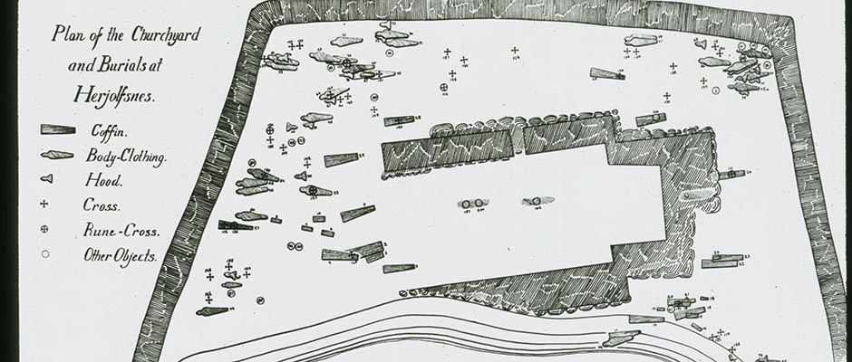
Amitsuarsuk
a fjord in the Julianehaab District of southern West Greenland,
about 17 miles long, lies next westward of Torsukatak channel and is
entered between Frederiksdal and Ikigait Promontory about 2 miles westward.
Flanked by precipitous shores and with altitudes in the east and north rising
to 4,900 ft., Amitsuarsuk extends in a general north-northwestern direction
with a river draining into its head. Frederiksdal (Narsak), the most
southerly of the Danish settlements in Greenland, is situated on the eastern
side of Amitsuarsuk, close within t [ ?] e fjord's entrance. Facing Frederiksdal
across the bay is Ikigait (Ostpröven), the Herjolfsness of the sagas. The latter
is famous for its Norse ruins, while Frederiksdal, the Sandhöfn of the
chronicles, was favorite port-of-call for the medieval Norvegian skipper
who came here to trade with the Norse colonists. " When after his dangerous
passage across the open sea, the skipper had safely rounded Cape Farewell,
the high mountains behind Herjolfsnes were consequently the point towards
which his longing looks were directed." (See Ikigait; Greenland. History.)Sail. Dir. II 23 Guidebook 205
001 | Vol_XIV-0281
Greenland 280
Arfersiorfik Fjord
in the Egedesminde District of northwest Greenland, has its approximate entrance between
Alangorsuak Peninsula and Sagdlersuak, an island nearly 8 miles to the north; from
here to the Inland Ice the main arm of the fjord extends about 92 miles in a general
east-southeastern direction.Close within its entrance Arfersiorfik broadens into an island -studded
basin, which, at some points, is more than 17 miles wide. Three branches lead from
the eastern end of the basin: 2 minor ones, which terminate shortly, and a broad
central arm which continues straight eastward and eventually narrows to the
channel Safartok, dreaded for its tidal rapids. Beyond Safartok another embayment
is formed, the greater part of which is occupied by 2 elongated islands, Korsung–
nitsok and Tunertok, both from 19-20 miles long, east and west. Two final
arms extend from the eastern end of the second embayment. The more southerly
one terminates about 30 miles farther eastward near the edge of the Inland Ice.
The more northerly arm, Amitsuarssuk, swerves northward past Nordenskiøld Glacier to
a wide bay, Tasiussarsuk, where it terminates. Sofia's Harbor (68° 22′N. 51° 11′W) ,
with charted depths of from 3 to 10 fathoms , stands north of Norderskiøld Glacier on the
eastern side of the bay. It was from this harbor that A.E. Nordensiø set on
on his exploratory journeys to the Inland Ice in 1883. The hills east- and northeast–
ward rose to 1,100 ft, with deep lake-studded valleys in between. The vegetation
is comparatively luxuriant , and eiderducks, which breed in the cliffs along the shores,
are plentiful.Se v v r al dwelling-places are on the outer shores of Arfersiorfik, but the
inner shore are uninhabited, although the rapids are important as around these
places the seals will gather.The depths in Arfersiorfik are unknown.
Sail. Dir. III 192 Guidebook 389 Greenland II, 61,165
001 | Vol_XIV-0282
Greenland
Arsuk,
a fjord in the Frederikshaab District of southern West Greenland, is
approached between the islands Sanerut and Sermersut, but has its actual
entrance north of Arsuk Island. The total length aproximates 18 miles, the
average width is about 2 miles. From its entrance Arsuk trends northward, then north
eastward and finally northwestward for about 12 miles, where it forks, the longer
arm curving northeastward to a glacier at its head. The shorter, western arm
continues northward for about 2 miles to Ellerslie Harbor (61° 17′N., 48° 12 ′W.) ,
the best and in, winter, the only safe harbor in Arsuk Fjord. Ivigtut (q.v.) is
on the eastern side of Arsuk, about 7 miles within the entrance, and on the
same side, about 3 miles beyond Ivigtut, is Grönne Dal Harbor, which has
a T-shaped pier, with about 300 feet of berthing space along its head.The shores of Arsuk are low and undulating and form a contrast
with the wild magnificence of the high islands offlying the outer coast. The vegetation
in the vicinity of the fjord is generally richer than elsewhere in the
district, with willow and alder growing to over 2 yeards. Depths in the middle
of Arsuk are everywhere great; in some places there is a depth of over 100
fathoms even within a few yards of the shore.Maritime traffic in Arsuk is relatively heavy, because Ivigtut, the
center of the cryolite mining industry, is located on its shores. Navigation
is facilitated by a number of beacons, but vessels are forbidden to enter
Arsuk waters except by specific permission from the Mining Management.
Vessels awaiting entry anchor at Kungnat Bay (q.v.)Ice off Arsuk is heavy from March to June, but sufficiently scattered to
make penetration possible. From July to the end of the year the coast in the
vicinity is usually clear of ice.Arsuk is the Aernlaugsfjord of the sagas, and Norse ruins occur inside
the fjord and along the deeply indented coast north and south of its entrance.cont.p.2
001 | Vol_XIV-0283
H.O. 76, 162 Guidebook 245 Greenland I, 202 ff.Indexer: list Ellerslie Harbor; Grönne Dal Harbor.
001 | Vol_XIV-0284
Frederiskhaab District Greenland 144
Arsuk (Putugok)
(61° 10′N. 48°32′W.) an outpost in the Frederikshaab District
of southern West Greenland, is on the north side of Arsuk Fjord, at the
[ ?] foot of Kungnat mountain (4,580 ft.)
The population in 1930 was 173 Greenlanders and 5 Europeans. Facilities
include a manager's house with store, warehouse of stone, small hospital,
chapel, school and about 25 dwellings. Due to the settlement's proximity
to the Ivigtut mines, a law was passed in 1912 to the effect y t hat the women
of Arsuk are forbidden to cross a line drawn between the two places; men are
permitted [ ?] to go to Ivigtut for trading purposes. Greenlanders from [ ?]
other districts may not visit Arsuk except on official business. The introduction
of social diseases and a growing number of half-breeds made this regulation
necessary. In 1944 Arsuk had about 360 sheep.Guidebook 270 Sail. Dir. II 162
001 | Vol_XIV-0285
Greenland 240
Arveprinsens Island (Prince Island)
in Disko Bay in northern West Greenland, is about 29 miles long, north and
south, and approximately 7 miles wide at its broadest. The western
portion of the island belongs to Ritenbank District,w hile the smaller,
eastern portion, facing Ata Sound, forms part of Ja kobshavn District.
The northern part of the island , which broadens like the top of a mushroom,
has 3 deep, parallel indentation with a direction south-west-northeast: Smalle
Bay, the most westerly, then Lange Bay (Kangerdluk, also named Zwarte Vogel
by the Dutch), and finally the va lley district with its large lake north
of At t a outpost. The latter indents the northeastern portion of Prince Island
but lacks an outlet to the sea except through a short river which drains into Ata Sound. The coasts, except in the northeast, are
steep and rugged and have a number of characteristic landmarks, with
prominent Cape Kangek (945 ft.) projecting from the middle of the west coast.
The island's highest altitudes (2,795 ft.) are in the central part of
Prince Island. Ata outpost (QV) and Arsivik, a dwelling-place to the north lie
are on the northeastern more accessible northeastern coast and belong to
Jakobshavn District. Ritenbenk, colony of Ritenbenk district, is on
a small island off the middle of the western coast. A few minerals occur
north of Lange Bay and in the lake district, but their economic value is
insignificant. (See also Ata Sound)Guidebook 450 Sail. Dir. IV, 59
001 | Vol_XIV-0286
Jakobshavn District Greenland 108
Ata
(69° 46 ′N. 50° 57′W.) a small outpost in the Jakobshavn
District in northern West Greenland, lies on Arveprinsens Eiland, on the western
shore of Ata Sound, about 38 miles north of Jakobs h avn Colony.
The houses which stand close together, do not face the Sound but a small
bay to the southward into which drains a rapid river. The official buildings
are a chapel-school, a trading-post and a storage house; the population
the people, in 1930 was 87 Greenlanders. In summer A [ ?] a usually stands
deserted as the people leave on hunting and fishing expeditions.
Anchorage for small craft is obtainable in the settlement bay.Guidebook 437 Sail. Dir. IV, 59
001 | Vol_XIV-0287
Christianshaab District Greenland
Akugdlit
(68° 39′N. 51° 15′W.) a small outpost in the Christianshaab District
of northern West Greenland, is at the western extremity of Akugdlit Island.
The population in 1930 was about 88 Greenlanders. A rich growth of grass,
flowers, heather and small bushes against a background of steep clif [ ?] , provide a pleasant setting for the village.
Anchorage is obtainable about 1/4 miles to the southward.
001 | Vol_XIV-0288
Jakobshavn District Greenland 265
Ata Sound (Ikerasak)
in Jakobshavn District in northern West Greenland, is formed by the
eastern (mainland) coast of Disko Bay and the off-lying Arveprinsens
Eiland. The Sound, which is about 23 miles long and from 3 to 5 miles
wide, is entered at latitude 69° 29 ′N. between Sigssarigsuk and Nunguak,
the southeastern extremity of Arveprinsens Eiland, and trends first
northward, then northeastward to a spacious basin at its head. The eastern
(mainland) coast has sheltered headlands with maximum heights of 1,800 ft.
At latitude 69° 3 9 1 ′N. Kangerdluarsuk Fjord branches off, extending
about 12 miles southeastward to a valley which connects with a branch
of Pakitsok Fjord. The western coast of Ata Sound (on Arveprinsens Eiland)
is almost without indentations and very steep, at least in its southern
portion. The northern stretch is lower and more accessible . and T t he outpost Ata (QV)
and the dwelling-place Arsivik stand along this coast. The large unnamed
basin at the head of Ata Sound opens out on Torsukatak Ice Fjord but passage
through the basin is obstructed by a groups of islands, one of which
a number of island. one large fairly large-sized island and a number
of islets x of which the northernmost, Igdlutalik, has well-preserved
Eskimo ruins, graves and "nangissat" dating to a period prior to the
n N orse Colonization.Depths within the Sound average more than 100 fathoms. Anchorage is
obtainable in several bays on the east coast and off Ata outpost on
the western side of the Sound.Guidebook 434 ff. Sail. Dir. IV, 57
Indexer: Note Igdlutalik
001 | Vol_XIV-0289
Greenland 144
Atanek,
a fjord in the Egedesminde District of northwest Greenland, is approached between
Tugtolik Island and Alangorsuak p ne en insula, about 3 miles to the north.
From this entrance , which is much encumbered by islets and rocks , Atanek extends southeast
ward for about 40 mi l es, narrowing towards its inner parts. The head of the fjord
comes very close to Amitsuarsuk, the more northerly branch of Nordre Strømfjord,
with which it connects by way of a portage.The only major indentation, Tasiusak Bay, is about 7 miles from Atanek's
entrance; it penetrates Alangorsuak peninsula in a northern direction, almost
severing it from the mainland in the east. Iginiarfik outpost stand at the
head of Tasiusak Bay, which is much frequented by local fishing craft.The hills flankingthe outerfjord are low, but those in the interior rise
to nearly 1,500 ft.The winter ice may last until July, but is usually gone in June.
Sail. Dir. III 190 Guidebook 388
001 | Vol_XIV-0290
Sukkertoppen District Greenland 84
Atangmik
(64° 48′N. 52° 08′W.) an outpost in the Sukkertoppen District of
southern West Greenland, stands on the mainland, about a mile east
of the northwestern entrance point of Angmasivik Fjord. The official buildings
are a modern trading-post, store and warehouse as well as a new chapel–
school. The inhabitants , which in 1930 numbered about 115, derive their
chief income from codfishing, cod being abundant in Angmasivik Fjord.
Anchorage for small craft is obtained in the broad bight west of
the settlement.Sail. Dir. III 84 Guidebook 325
001 | Vol_XIV-0291
Julianehaab District Greenland 96
Bangs Havn
(60° 48′N. 47° 52′W.), a harbor in the Julianehaab District of southern West
Greenland, indents the northwestern shore of Nunarsuit Island to a distance
of about 300 yards. The entrance, which opens from Torsukatak channel,
is s a bout 800 yards wide; dpeths inside the bay range from 3 to 12 fathoms.
Low, rocky country borders the southern and western sides of the harbor, while
the eastern side is formed by a sandy peninsula that projects northwestward
from Nunarsuit Island. Two beacons are located near the harbor's western
entrance point.Bans Havn is considered the best emergency harbor in Torsukatak channel (QV).
Sail. Dir. II. 31
001 | Vol_XIV-0292
Godthaab District Greenland 120
Bukse (Kangerdluarsunguak)
a fjord in the Godthaab District of southern West Greenland, less than 1 mile
wide and about 17 miles long, extends almost parallel with the outer part
of Ameralik Fjord, its neighbor to the north, but is eventually lost
among bare, steep parabolic mountains. Two rivers flow into the head of
Bugse, the more northerly of which connects with the rivers that feed
Ameralik that feed Ameralik in the north and Alangordlia, a branch of
Sermilik, in the south. Utorkamiut, a small, all-Greenlander settlement,
stands close to the entrance of the fjord.Bukse was part of the Vestri Bygd or Western Settlement of the
Norse, and ruins of their Norse farms have been located in the river valley at its
head.Sail. Dir. III, 38 Guidebook 292 Geogr. Rev. Oct. 1943 Map p. 549
001 | Vol_XIV-0293
Holsteinsborg District Greenland
Cape Burnil
(66° 30′N.53°40 W.) , in the Holsteinsborg District of
southwest Greenland , lies on the southern side of the approach
to Itivdlek fjord. It was named by James Hall in 1605.Guidebook 355 Sail. Dir. 149
001 | Vol_XIV-0294
Greenland
Christianshaab,
a district in the Northern Inspectorate of West Greenland, is the strip
of ice-free coast between the widely curving northern boundary line of
Egedesminde District and Jakobshavn Ice Fjord, or, roughly, between
latitudes 68° 20′N. and 69° 10′N. The total area of ice-free land
between the sea and the Inland Ice approximates 1,160 sq. miles. The popu–
lation in 1944 was 672. The colony and administrative center is
Christianshaab settlement, which has the only harbor in the district.
Trade-in-production for the year 1944-45, after deduction of local
shipments, was as follows: blubber 23,214 kg; liver 55,657 kg; blue
and white fox skins 84; reindeer skins 32; s l a lted fish 270, 650 kg;
halibut 4,245 kg; feathers 200 kg.The southern part of the district follows the curve of Southeast (Sydöst)
Bay and at its southwestern end projects to a point west of Ikamiut Island.
The shore here is composed of lowland with large stretches of sand and clay;
cliffs and a few peaks rise above the coast and project into the bay as
capes and promontories. To the southeastward is a vast alluvial plain
surmounted by scattered gneiss hills and with a vegetation sufficiently
rich to maintain large herds of caribou. Numerous fossils of mussels and some
fish indicate an up t lift of land similar to that which occurs elsewhere
in the district, east of Orp o i gsok Fjord and south of Claushavn. North of
the plain, alongside the eastern shore of Southeast Bay, two fjords
with a common entrance, Opigsok and Kangersunek, indent the mainland to
a distance of about 11 miles.The northern part of the district faces Disko Bay on the West. It is
dominated by gneiss ranges rising to heights of from 1,300 to 1,700 ft.
There are no conspicuous landmarks along this coast, and navigators frequently
002 | Vol_XIV-0295
Christianshaab District cont.
identify the region by the peculiar light over Jakobshavn Ice Fjord which
results from the reflection in the clouds of snow- and ice-bound terrain.The vegetation in the district includes large heath of dwarf
birch and willow and a rich growth of the Greenland-American cranberry. [ ?]
Scattered belts p o f strand belts occur on the coast and on the cla i y ey
plains away from the sea. Game includes caribou, foxes, and ptarmigan
which are hunted for sale to Danes. Eiderducks breed in the coastal cliffs
and the fjords and coastal waters are rich in fish.No series of meteorological observations are available, but the
climate of the district is considered the most favorable in the Northern
Inspectorate. The prevailing weather both summer and winter is clear and
calm, with summer temperatures rising to 68° F. in the shade. Fog is rare
and precipitation is slight. Strong foehn winds from the southeast can
be persistent. The sea ice along the coast generally remains from Christmas
or early January until May, in the fjords and inlets even longer, but
voilent southeast winds may wuickly break up the ice and send it
drifting seaward.History. - The Norse of the early Middle Ages went on hunting
journeys as far as Disko Bay and may have settled along this coast; but
the district contains ruins ante-dating even the days of the Norse, that
is their rectangular houses of the 11th and 12th centuries. Some of
these ruins are so old as to be inundated at high water. In modern times
it was the Dutch whalers who first traded along the coast of what
is today Christianshaab District.Greenland I 13, 128 II,13 Guidebook 402 H.O. 76, 19
001 | Vol_XIV-0296
Greenland
Christianshaab (Kasigianguit)
(68° 49′N., 51° 11′W.) , the colony and administrative center of
Christianshaab District in the Northern Inspectorate of West Greenland,
stands at the head of a small bay that opens outward onto Disko Bay, or rather
on the landward side of a short peninsula that separates the harbor from
the sea. The population in 1938 was 153 Greenlanders and Europeans.
The houses, which include the usual public buildings such as a church,
school, manager's residence and trading post, are scattered up a fa ri ir ly
steep and fertile slope and are exceptionally well kept, their brightly
painted walls adding color to the background of brownish rock and regetation.
There is a radio station at Christianshaab and an oil refinery on Kuilik,
one of the outlying skerries, but no hospital and no resident physician. The
town is surrounded by coastal cliffs of a rather uniform character, but the qui
quiet clear basin to the south and the numerous off-lying islets drawing a
semi-circle around it, land an idyllic touch to the landscape. There is
a river on the eastern side of the bay and many small streams in the
green valleys back of the colony.Harbor. - The inner harbor fronting the town has a depth of from
2 to 5 fathoms, but the anchorage, that is generally used, lies off the
northern entrance of the basin between the mainland and the nearest
island, Kuilik. Charted d epths here range from about 12 to 20 fathoms.
Owing to the winter ice, the harbor is not navigable until the end of
June, but the anchorage usually is ice-free a few weeks earlier.
icebergs and calving ice rarely hinter navigation here, as the
basin is large and at least one of the several outgoing channesl
002 | Vol_XIV-0297
Christianshab Colony continued Greenland
is likely to be open. The off-lying islands and skerries are all low, with the
exception of Savik, the largest of the islands, which rises to 272 ft.History. - The colony was founded in 1734 by a Danish merchant,
Jacob Severin, who named the place after the Danish King. The colony gained
its first commercial impetus when Niels Egede, son of Hans Egede, lived as
trader and missionary here from 1740 to 1743. Niels Egede also directed
a good deal of effort toward strengthening Danish sovereign rights in these
waters and toward paralyzing the encroaching Dutch trade. How e ver, the fortunes
of the colony declined when trade in Greenland became a government monopoly
in 1774, and there was a further slump when in 1782 additional restrictions
were imposed through the establishment of the Inspectorates. The recovery of
Christianshaab dates only from the beginning of this century. The colony is
considered the only one in Greenland to have retained the atmosphere of Old
Greenland, i.e. eighteenth century Greenland. (See also Christianshaab District).Guidebook 407 ff. Sail. Dir. IV, 40 ff. H.O. 76, 312 Greenland III. 112
Indexer: list Kuilik Island
001 | Vol_XIV-0298
Christianshaab District Greenland
Claushavn (Ilimanak)
(69° 05′N. 51° 07′W.) ,
an outpost in the Christianshaab District of North Greenland, with a
population of 323 Greenlanders and 2 Europeans (1930 census), lies
on the eastern coast of Disko Bay, about 19 miles north of Christians–
haab colony. The houses are scattered over a grassy plain about 2 miles
inland alongside a river which drains a large lake to the east. The
official buildings , which include a school, church, manager's residence,
store and warehouses, together with some residential buildings are grouped
along the north shore of this river, while most of the Greenlander dwellings
are on the southern shore. Due to the proximity of Jakobshavn Ice Fjord,
which lies less than 4 miles north, the climate is somewhat more severe
than elsewhere in the district, but clear, calm days are frequent both
summer and winter. There is no real harbor at Claushavn, but an emergency
anchorage may be obtained between the off-lying islets and skerries.History.- A The first house to serve as a dwelling for the missionary and for
traders of expeditions was built here in 1741, but the mission itself
developed only after Hans Egede Saby, the son of a daughter of Hans Egede,
took up residence here in 1770. Like all the Egedes , he had energy and skill
and a good deal of influence with the Greenlanders. Within the eight years
of his residence h e re 380 out of 480 people in the the region had beco [ ?] me
converted to c C hristianity.Sail. Dir. IV, 46 Guidebook 414 Greenland I. 130, III, 309 ff.
Unpaginated | Vol_XIV-0299
Christianshaab District Greenland
Claushavn (Ilimanak)
an outpost in the Christianshaab District of North Greenland with a population
of 323 Greenlanders and 2 Europeans (1930 census), lies on the
001 | Vol_XIV-0300
Frederikshab District Greenland
Coppermine Bay (Kobbermine Bugt),
in the f F rederikshab District of southern West Greenland, is entered between the
northwestern extremity of Alangorsuak and the southwestern end of Sanerut Island,
about 12 miles north-northwestward The Bay extends about 26 miles northeastward to the
edge of the Inland Ice, but narrows about 6 miles within its entrance and for the
rest of its course is encumbered with a chain of islands that extend all the way
to the head of the Bay. The innermost islets are clay plains formed by gla–
cial deposits carried there from the Inland [ ?] ce. The channel south of these islets
dries at low water. The channel north of the chain, which is sometimes called
Sanerut Fjord, is navigable and connects by a narrow passage with the head of the
fjord north of Sanerut Island. Sanerut fjord, with depths ranging from 8 to
109 fathoms, is more open than the water in the southern part of the Bay, where
large icebergs drift in and ground around the numerous islands. The outer part
of Coppermine Bay has general depths of more than 25 fathoms.Borgs Havn, a cove on the northern side of the outer B b ay, affords
anchorage in depths of from 7 to 12 fathoms. Ellen's Havn, a bight on the
north shore of Alangorsuak Island, about 5 miles from its western end, has depths
of from 7 to more than 20 fathoms. On Alangorsuak, too, about 4 miles northeast
of Ellen's n H avn , is the famous Josua Coppermine, so named after a Greenlander who
discovered it in 1853. The copper ore makes a vein in a formation of mica and
chloride schist and contains a very small amount of silver and gold. Mining
was kept up for a number of years b u t ultimately abandoned as unremunerative.Coppermine Bay marks the southern boundary line of Frederikshab District.
Sail. Dir. II,138 Guidebook 240 Greenland I.234 III 297, 343 ff.
001 | Vol_XIV-0301
Greenland
Disko Bay
in northern West Greenland, is entered between Egedesminde and Godhavn Colonies or
between latitudes 68° 42′N. and 69° 14′N. respectively. From here
Disko Bay, with Sydøst Bay adjoining it in the southeast, extends about 69
miles eastward to the coastlines of Christianshaab,Jakobshavn and Ritenbank
districts. The northern limitof the bay is Disko Island , with Vaigat Sound
to the eastward constituting an outlet for its waters in the northeast.
A chain of islands, including Rotten Rock, Hunde-, P K ronprinsens and other
islands, stretch across the entrance of the bay, forming a major obstruction
to navigation. Depths in the interior are nearly 220 fathoms except off
Jakobshavn Ice Bank (136 to 164 fathoms,) , but navigation is generally
tricky due to shoals and insufficient soundings. Four colonies are
on Disko Bay's shores: Godhavn on Disko Island, and Christianshaab, Jakobshavn
and Ritenbenk on or off the mainland coast in the east. A fifth colony, Egedes–
minds lies just outside the southern entrance to the bay. Good a A nchorage is
obtained off the colonies and in various other places.Ice.- The East Greenland Pack Ice from the south rarely reaches Disko Bay.
The West Ice, if it comes here, arrives in winter and freezes with the coast ice
at Godhavn or Kronprinsens Eiland. Winter ice forms between December and
May. Disko Bay is usually free of fl [ ?] ice from june to the end of the year,
but icebergs, some 200 to 300 ft. high, issue in great numbers from the
glaciers inland and drift back and forth with the tides.History.- The Norse, who first navigated Disko Bay around the year 1000,
came here for seal and whale, but they had no settlements here. The bay first
was opened to commercial traffic in the 17th and 18th centuries,
002 | Vol_XIV-0302
Disko Bay continued Greenland
when Dutch whalers started trading with the Eskimoes of the coasts.
[ ?]
The Dutch had harbors on the southern shore of Disko Island: Fortune Bay, about
7 miles west of Godhavn, Liefde Bay (Bay of Love), which is to-day Godhavn
port, and Disko Reede ( probably Skansen) east of Godhavn. Mt. Iviangernat
back of Skansen was named by them De Schans (the redoubt) , because of the three hummocks
on its top. H arbors on the mainland were included Makelyk Oud (comfortable old age)
which to-day is Jakovshavn Bay and Rode Bay (Bay of Rest. ) The Dutch, too,
left maps and sailing directions which are serviceable even to-day. Their
commerce in Disko Bay was eventually paralyzed by the activities of Danish
missionaries and traders, who helped establish Danish sover e ignty in these
waters. In 1739 three ships of the Danish trader Jakob Severin and a small
Dutch flotilla fought the first and last naval battle ever to occur in
Disko Bay. It took place off Jakobshavn and ended with the defeat of the
Dutch. To-day Disko Bay is regarded as a part of greenland's national waters to which
no ship is admitted except by special permission of the Danish Government .
(See Fisheries and Hunting Act of April 1st, 1925 for the delimitation
of Greenland's territorial waters.)Guidebook 443 ff Sail. Dir. IV 1 ff. Greenland I.19,189.221 II.340 III.25.
84,106
001 | Vol_XIV-0303
Godhavn District Greenland
Disko Fjord (Kangerdluk)
in the Godhavn District of northern West Greenland, is the largest
and southernmost of the 3 fjords that indent the southwest coast of Disko
Island. It is entered between Maligiak and Kakertarssuk, a point about 11
miles tio the north and from here extends about 12 miles eastward to a projection
named Siorak where it fans out in three directions. Most of T t he outer channel
has a n average width of from 7 to 8 miles, although it is partly blocked by with Kekertak
island, about 6-1/2 miles long, east and west, which lies in its middle. dividing it into 2 major channels.The 3 inner branches, which penetrate deep into the high-alpine plateaux
pleaux of Disko Island, narrow to a width of from 1 to 3 mi l es. The
northernmost arm curves first northeastward, then northwestward toward
a head which is mud-clogged for 3 miles along its eastern shore.Its total
length is about 7 miles. Two large, moraine-filled valleys converge east
of the head, the first connecting with Mellem Fjord , to the northwest , the second
w i th the head of North Fjord (via North Fjord Pass) . to the north .The middle arm,Kangerdluarsuk trends in a northeasterly direction.
It is about 6-1/2 miles long and dotted with above and below -water rocks.The southern most arm is the main branch of Disko Fjord. It extends
eastward to a point about 7-1/2 miles beyond its junction with Kangerdluarssuk.
There it sends a [ ?] 6-mile arm, Kangikidtlek, eastward for about 12 miles
to a mud-clogged head into which drain two glacier-fed streams. The main
arm continues northward then eastward for about 12 miles to the terminal
point of a wide valley (Kuanersuit) which leads [ ?] to the western rim of
Stor Braeen (Big Glacier). The fjord itself has magnificent alpine scenery
with altitudes in the east (Akuliaruserasuak) rising to 4,048 ft.Of the many small settlements inside Disko Fjord only Evkitsok (Disko–
fjord) (QV) inside Kangerdluarsuk has outpost size. Anchorage is charted
here and in Kuanit, a bight on the north shore of outer Disko Fjord.There are mid-channel depths of more than 50 fathoms on the southern side
002 | Vol_XIV-0304
Disko Fjord cont. Greenland
side of Kekertak Island in the outer Fjord , with depths increasing to
nearly 90 fathoms off the entrance of Kangerdluarsuk.Sail. Dir. IV 81 ff Guidebook 484
001 | Vol_XIV-0305
Greenland
Disko Island
in northwest Greenland, between latitudes 69°14′and 70°20′N. and longitudes
51° 52′and 54° 59 ′W., covers an area of about 3,204 sq. mi. and is probably the
largest island off the coast of Greenland. To westward and eastward it faces "
Baffin Bay and Disko Bay respectively; its northeastern shore is bounded by
Vaigat Sound. Ritenbenk District (north) and Godhavn District (south) share
in the administration of the island.The coasts differ in geological composition. The east coast slopes more
gently, land-forms are more undulating, and the rocky land, which is more
predominantly sandstone, is usually greyish, with only light overtones of brown
or black basalt. The cliffs and plateaux in the west and north are typical
basalt formations, murky-colored and firm in texture, and with only narrow
strips of eroded foreland left bwteen them and the sea. The coasts are remarkably
straight throughout except in the west where North F h j ord, Mellem and Disko Fjords
form deep indentations. The whole inner area is occupied by grand volcanic
strata resting on sedimentary rock. Along the Vaigat the horizontal plateaux
with maximum heights of 6,296 ft. (Mt. Pyramiden) lie nearly unbroken behind
the coastal rock. To southward s facingBaffin and Disko Bays , the land is slightly
lower and deep valleys extend from coast to coast or far inland where they
are absorbed by the glaciers. From a height of 3,300 ft. upwards the country is
covered by highland ice which gives rise to innumerable glacier. Largest of the
glacierized plateaux, Big Glacier (Stor Braeen) in the eastern portion of Disko, extends for
aboutt 40 miles in southerly-northerly direction. All the large rivers are gla–
cier streams, and most of the valleys are filled with moraine deposits. The
heads of the fjords are so clogged with sand and clay that boats cannot penetrate.
Exept in the gneiss areas , Disko is poor in lakes, but there are lagoons along the
coast separated from the sea by gravel bars. Characteristic of the volcanic
nature of the island are its warm springs which have temperatures varying from
37° to 64° F. Disko also has mud volcanoes,none active (in 1946) but showing
002 | Vol_XIV-0306
Disko Island cont. Greenland
signs of having been in action not so long ago. No minerals of any
economic significance so far have been found on the island, but coal
is mined in various places along the coast Much driftwood arrives off the
West Coast, so that the population here has little need to purchase timber
for their houses and kayaks. Disko Island is usually accessible to
ships from April to November. The coasts, like the rest of Greenland
are sinking.The island was already known to the Norse who called it Bear Island.
According to the sagas in 1003 or 1004 Thorfinn Karlsefni sailed from here
to the North American mainland for a three-year colonization effort.(See also Ritenbenk District; Disko Bay . Fir flora and fauna, climate and
ice conditions see Godhavn District.)Guidebook 470 ff. Polar Record Jan. 1946 p. 326. Sail. Dir. 19 ff. IV
001 | Vol_XIV-0307
Greenland
Egedesminde,
a district in the Northern Inspectorate of West Greenland, includes the
broad, ice-free belt between North Strömfjord on the south (67° 28′N.)
and the outer islands, off the southern shore of Disko Bay (68° 51′N.)
In the west the district is washed by the waters of Baffin Bay; toward the east
it is limited by the edge of the Inland Ice, except for a small corner in
the northeast where the district line runs from Tasiursarssak northwestward
to a point south of Ikamiut Island. The maximum width of the ice-free
coast is about 124 miles. The population in 1944 was 2,304. The colony
and administrative center is Egedesminde which also affords the best anchorage
in the district. Trade-in-production for 1944-45 (after deductions for
local consumption) was as follows: blubber 85,372 kg; liver 99,018 kg;
salted fish 863,000 kg; dried fish,1586 kg; eiderdown 141 kg; feathers
2,144 kg; blue and white fox skins 469.The district which, as to scenery, is the flattest and least spectacular
in West Greenland, presents a maze of peninsulas, fjords, islands and
sounds, sheltered in the west by a belt of innumerable islets and rocks.
Nevertheless, the land falls naturally into two sections, a northern
and a southern one, divided midway by the widely ramified Arfersiorfik
Fjord. The southern part is in the main an elongated peninsula between
Nagsugtok and Arfersiorfik fjords, cut up on its southern side into numerous
barely connected peninsulas. The northern district consists of the large
interior area, called Naternak, and the "Skaergaards" to the north and
west of it.The vegetation in the interior is abundant, and as a result caribou
were formerly found everywhere, but are now decreasing in numbrs, due to
overhunting. Foxes, ptarmigan and hares occur, and seals are hunted
offshore the year round. The hunting of eiderucks and other seabirds
002 | Vol_XIV-0308
Egedesminde cont.
o i s of considerable importance to the population which still makes use of bird
darts to make a kill. A major pest in summer are the mosquitoes, bred
in the lakes and ponds in the interior and in the stagnant pools on the
outer islands.Compared with Jakobshavn in the north, the region around Egedesminde
has less cold in winter, and less heat in summer. The average temperature in
summer is a little above 41° F.; during the wintertemperatures hover around
3° F. The prevalent winds are north, east and southwest, but there is
a foehn-like wind, called Avangasik, which may blow down into Disko Bay
from the northeast and east-northeast; when it reaches the district it
interrupts all communications at sea. Precipiation is heavy and fogs are
frequent. Within the fjords the climate is clearer and more dry.Ice off the district coast forms at the earliest in September, at the
latest in February; the break-up occurs between April and the early part of
june. In the fjords solid ice usually forms about New Year.Communications inside the district are maintained by a network
of sledge routes, a main trail far inland connecting Southeast (Sydöst) Bay in t
the north and Holsteinsborg colony in the south.The district coast was first mapped by James Hall in 1605.
H.O. 76, 19 Guidebook 373 ff. Greenland I,10 II, 62,162
001 | Vol_XIV-0309
Greenland
Egedesminde (Ausiait)
(68° 42′N. 52° 52′W.)the colony and administrative center of Egedesminde
District in the Northern Inspectorate of West Greenland, with a population
(1940) of 420 Greenlanders and 30 Danes, is on Ausiait Island in the Egedesminde
Archipelago, just south of Disko Bay. The colony, which faces a fairly large bay,
is spread over a wide area, its business and other official buildings lying more
to the eastward, while the hospital and the Greenlander dwellings are on a
steep slope to the southward. The two parts of the village are connected by
a paved road with a cement bridge leading over a small stream. Public facilities
include a school, a small hospital, a moving-picture house and a weather- and radio-station ( call OYR ), the
latter situated on Raeve Island near Tupilak Point. The most conspicuous building
is the two-stories church on the east side of the colony, which is fairly
new and has a cross on its gable. Small carpenter and machine shops are equipped
to make minor repairs. Other more recent installations (since 1940) include
large warehouses and electricity. Water is piped into the colony in summer
and sledged in in barrels in winter, but is considered contaminated except
for that which can be obtained at Tupilak Point. Egedesminde is main port of
distribution for North Greenland.The harbor, which is safe but not very large, lies in a bay that is
formed between the northwestern end of Ausiait Island and the northeastern
extremity of Raeve Island. From its entrance at Tupilak Point it extends
about 1/2 mile southeastward, then southward for the same distance. An islet,
Kuilik, divides it into an outer and an inner harbor with depths ranging
from 7 to 20 fathoms. A number of beacons offer navigational aid.The West Ice usually arrives off Egedesminde about the first of
January,sometimes freezing with the coast ice, and leaves about the middle of April.
002 | Vol_XIV-0310
Egedesminde Colony cont. Greenland
In the neighboring bays and channels the freeze-up omes earlier. The winter
ice may remain in the harbor until the beginning of June or later.The colony was first founded in 1759 by the trader Niels Egede who named
the settlement after his father Hans Egede. It was originally situated on
Ekalugssuit Bay, 5 miles north of Nordre Stroemfjord, but was removed to
its present location in 1763.(See alsoe Egedesminde District)
Sail. Dir. III 208 ff. Guidebook 398 ff. Greenland III,123
001 | Vol_XIV-0311
Julianehaab District Greenland
Eggers Island ,
the southernmost island in the Cape Farewell Archipelago of southern
West Greenland, is a shell-shaped island about 17 miles long, east and west,
and about 14 miles wide in its broadest part. The channels Ikek and
Ikerasak bound its northeastern and northwestern side respectively.The northern slope of the island is low and cut through by fertile
valleys, and here, close to the southeastern entrance of Ikek Sound, is the
Eskimo dwelling-place Itivdlek, with a population of 50 in 1942.The southern shore, which is wild and mountainous, is deeply indented
by two inlets, Kangia and Itinera, and split into three precipitous pro–
montories of which the middle one rises to an elevation of 2,210 ft. At the
southern extremity of the island rises Cape Farewell, a bee-hive shaped rock,
900 ft. high, which is connected with the country northward by a low spit of
land. Cape Christian, 1,550 ft. high, projects off the southwestern extremity ofthe
island.¶ Highest elevations in the interior are Kunerik in the north, rising to
2,984 ft., and Itivdlek Fjeld in the east with an altitude of 2,881 ft.Sail. Dir. II,17
001 | Vol_XIV-0312
Greenland
Evigheds Fjord (Kangerdlugssuat s iak),
in the Sukkertoppen District of southern West Greenland, has its 1-mile wide
entrance southeast of Kangamiut Island (Old Sukkertoppen). From this position
the fjord trends first northeastward, then southeastward and again north–
eastward to a head approximately 55 miles distant. Several short fjordarms
lead from the main fjord at various points, the outermost one extending north–
eatstward to the enormous bulk of Mount Atter (Taterat) which rises to
7,300 ft. The shores of the head of this section are high and steep with
some of the rock-surfaces long the northern shore rising unbroken for 3,000 ft.
Taterat glacier, which leads down from the Sukkertoppen Ice Cap and has it's
snout at the foot of Mount Atter, calves into the fjord at frequent intervals. In the inner reaches of Evigheds Fjord
glacier tongues come down to the fjord at intervals of 1 to 3 or 4 miles
between small protruding nunataks.Depths within the fjord are apparently gen n erally great with soundings ranging
from 115 to 300 fathoms.There are no settlements around the inner part of the fjord , but Timerdlit, a small
dwelling-place, is near the fjord's northwestern entrance point.Sail. Dir. III.103 Guidebook 335
Indexer: list this fjord also under Kangerdlug seuatsiak.
001 | Vol_XIV-0313
Greenland
Evkitsok (Diskofjord)
(69° 29′N.,53° 57′W.), an outpost in the Godhavn District of northern
West Greenland, lies on the western side of Disko Island, just inside the entrance of Kangerdluarsuk, a
branch of Diskofjord. The population in 1930 was 42 Greenlanders. The offi–
cial buildings are a store, a manager's house and a warehouse. The dwellings
are scattered in small groups around the entrance of Kangerdluarsuk. The
entire region, which is comparatively fertile, is known as Siorak. Ancho–
rage is indicated immediately of Evkitsok and in a bight 2 miles farther
east.H.O. 76, 331
001 | Vol_XIV-0314
Greenland
Faeringerhavn
(63° 41′N. 51° 34′W.), the Faroe Islander s' , harbor in Greenland and meeting-ground
of the cod-fishing fleets of all nations, is in the Godthaab District of southern
West Greenland, about 34 miles south of Godthaab Colony.The harbor, which is conveniently located between two of the main codbanks
off-shore - Fylla and Fiskenaes , - is large, has a suitable depth, is free from
pack ice and is protected from the sea by towering islands. A number of
beacons, range and harbor lights offer navigational aid. There is a radio–
station (call OYU), a hospital and a telegraph office, a motor repair shop [ ?]
and a shipwright's shop here. A Danish doctor and nurse are in residence during
the summer.Originally designated to serve as shelter to the large Faroe fishing
fleet, which since 1925 has come annually to fish on the rich codbanks off–
shore, Faeringerhavn in 1937 was opened to ships of all nations and up to the
war was kept open each year from May 1st to October 31st. Annual figures
for fresh-caught cod off the coast of Greenland have ranged between 6 and 7
million kilo since 1930. The all-time record in 1942 was about 110-1/4 million
kilos, equaling 7305 tons of cleaned, salted fish.Sail. Dir. III. 36 Guidebook 291 Geogr. Review Oct. 1943,p/553
(Jackson: With the Doctor boat
along the Greenland coast.)
Unpaginated | Vol_XIV-0315
Greenland
Faeringerhavn
(63° 41′N. 51° 34′W.) in the Godthaab Colony of southern West Greenland
001 | Vol_XIV-0316
Greenland
Cape Farewell (Umanarsuak)
(59° 45′N. 43° 54′W.), Greenland's most southerly projection, is a bee–
hive shaped rock, 900 ft. high, which rises off the middle of the south coast
of Eggers Island and is connected with the wild jagged country behind it by a
narrow, alluvial isthmus. The Cape itself is too low to serve as a landmark, but
mountains close north of it rise to heights of from 2,100 to 2,900 ft. and can
be sighted far out at sea. Numerous low islets and skerries fringe the Cape at
a distance of from 1 to 3-1/4 miles. South of Cape Farewell the ocean has
a depth exceeding 1000 fathoms at a distance of about 1 degree of latitude from the
shore; however, a submarine ridge, running towards the south, divides the deep
basin south of Greenland into a smaller easterly and a larger western part.The sea is extremely rough around the Cape, particularly in winter and
spring, with w i nds in April averaging a velocity of 5.3′(Beaufort). The warm
Atlantic current ( [ ?] rminger Current), sweeping the southwest coast of Iceland
on its way to the northeast, passes close by the East Greenland Current off
Cape Farewell and makes atcommonly frequented highway for temperature minima
passing towards the northeast. In summer conditions are calmer with weak southerly
winds prevailing.Heavy Ice of the East Greenland pack, carried southward and southwestward
by the East Greenland current, usually makes its first appearance off Cape Farewell
in December or January. It seldom sets northward around the cape to the southwest
coast of Greenland until the strong northerly winds abate in April. Normally during th
the ice season the outer edge of the pack around Cape Farewell lies about
60 miles out from the shore. In j J une and July when the he a vy polar ice reaches
its greatest abundance, the edge of the field has been met with 100 to 200 miles
off Cape Farewell. By late August t o r early September the Cape is usually free
from ice and remains so until toward the end of the year. Icebergs may be encount–
ered outside the belt of packice; on rare occasions bergs drift as far east as
002 | Vol_XIV-0317
Cape Farewell cont. Greenland
longitude 31° W. and as far south as lat. 52° N.Cape Farewell, the Statënhuk of the Dutch, was first named
by John Davis in 1 585 .Sail. Dir. II.17 Greenland I. 188, 423. III 232
001 | Vol_XIV-0318
Julianehaab District Greenland
Cape Farewell Archipelago ,
a group of large and small islands off the southern coast of Greenland,
is separated from the mainland by the Prince Christian Sound Passage, consisting of
Torsukatak, the outer part of Ilua and Prince Christian Sound (Ikerasarsuak).
The largest and easternmost island in the group is Prince Christian IV Island;
Eggers Island, with Cape Farewell at its southernmost extremity, lies farthest
to the south.The climate of the Archipelago is raw, and vegetation is sparse; the
terrain is rugged, with altitudes rising to over 4,000 ft.Frobisher first rounded the Archipelago in 1576, by which time
knowledge of the "Greenland" of the Norse had become a mere legend, so that
he himself believed to have sighted "Frieseland", a mythical island shown
on some maps of his period.Guidebook 203 Stef. Greenland,p.222
001 | Vol_XIV-0319
Greenland
Fiskenaes (Fiskernaes, Fiskernaesset, Fish Point)
(63° 05′W. 50° 42′W.), an outpost and fishing center in the Godthaab
District of southern West Greenland, is on an unnamed island a s ome 80 miles
southeast of Godthaab Colony. The population in 1930 was 297 Greenlanders and 4 Danes, [ ?]
but in 1943 the only Dane in residence was the wife of the Lutheran pastor, the pastor
himself being a member of a noted native family . The official building include
the usual manager's residence, store, warehouse, rectoryb, church and schhol.
Kekertarsuatsiak, T t he Eskimo name of Fiskenaes, Kekertarsuatsiak, derives from the high, dome-shaped
mountain north of the settlement.Fiskenaes and the settlements Graedefjorden, Ugarsiorfik, Lichtenfels
Kangigdlermiut form a single munic ipal ity in the judicial district of Godthaab,
in the parish of Godthaab.Sail. Dir. III 15 Guidebook 287 Geogr. Rev. Oct. 1943
Unpaginated | Vol_XIV-0320
Greenland
Fiskenaes-Lichtenfels
These 2 small settlements in the Godthaab District of southern West Greenland
usually figure as one, although they lie 2-1/2 miles apart.Fiskenaes
001 | Vol_XIV-0321
Greenland
Fiskenaes Bank (Fiskenaesbanke)
a fishing bank off the southwest coast of Greenland, extends from the
Kagssissagdlik islets outside Fiskenaes in the Godthaab District to
a point about 40 miles northwestward. The bank has an average width of
about 28 miles, and a minimum depth (rock) of about 22 fathoms.
Fiskenaes Bank, like the smaller Danas-and Frederikshaab Bank to the south,
is rich in cod and halibut and important to commercial fishing off
the west coast of Greenland.Guidebook 288 Sail. Dir. III,13
001 | Vol_XIV-0322
Greenland
Frederiksdal (Narss å k)
(60° 00′N. 44° 40′W.), in the Julianehaab District of southern West
Greenland, lies on the eastern side of Amitsuarsuk Fjord, close within its
entrance. Frederiksdal is Greenland's southernmost Danish settlement and
one of its earliest sheepraising centers. Its population in 1930 was 555.
Public buildings include a stone trading-house, a church, parsonage, school
and communicty center. Anchorage is indicated in the northern part of Frederiks–
dal bight.Prior to 1940 vessels did not call at Frederiksdal and supplies were sent
in by boat from Julianehaab. However, its harboring facilities were already
known to the medieval Norvegian skippers who traded with the Norse colonists.
They made Sandh ø vn (Dandy Havn), as Frederiksdal was called, their favorite
port of call. The present settlement was established as a Moravian Mission
in 1824 by Joh. Conrad Kleinschmidt, father of the famous linguist Samuel
Kleinschmidt.Guidebook 203 Sailr. Dir. II 24 Stef. Greenland 287
001 | Vol_XIV-0323
Greenland
Frederikshaab,
a district in the southern Inspectorate of West Greenland, extends
from Coppermine Bay (60° 57′N.) to Tuluvartalik (63° 31′N.), or
more specifically to the northern edge of Frederikshaab Iceblink. The
population in 1944 was 1,272 Greenlanders. The main trading center is
Frederikshaab Colony; the best harbor is in Kungnat Bay. The district
derives its r e venues primarily from royalties of cryolite, mined at
Ivigtut (q.v.), which furnishes the world's main supply of that
mineral. In addition there is export of blubber, liver, dried and
salted fish, blue and white fox skins and bird feathers. There were
about 542 sheep in the district in 1945.The icefree part of the district coast is rather narrow, with the
Inland Ice descending almost everywhere to the heads of the wide fjords.
Heights are generally lower than farther southward, with gneissic rock pre–
dominating. Among the more spect u a c ul ar seamarks is Frederikshaab Iceblink
at the northern extremity of the district coast. It is a lofty,pre–
cipitous cliff, formed by the land ice or glacier extending to the water's
edge and hiding from sight the whole of the actual shore. The vegetation,
as elsewhere in Greenland, is poor on the coast, richer inside the fjords, where
willow and alder grow to heights of one to two yards. Game include
caribou and hooded and Greenland seal. Polar bears and whales occur but
rarely. Some of the fjords and almost all of the rivers are rich
in salmon, and there are several birdcliffs in the region where eiderducks
winter in large masses.Clima c tic conditions in the district vary little, because of the
small amount of icefree territory. Mean temperatures at Ivigtut range
between 19° F. in January and 50° F. in July; the winter minimum is
-20° F.; the summer maximum 80° F. Average yearly precipitation
002 | Vol_XIV-0324
Frederikshaab cont.
at Ivigtut is 44.9′.Pack ice off the southern coast of the district usually lasts from
April to June, but large masses of ice may continue to appear in the
north, while the southern part of the coast remains unobstructed.H.O. 76, 19 Guidebook 242 Greenland I 429 III 235
001 | Vol_XIV-0325
Greenland
Frederikshaab (Pamiut)
(62° 00′N., 49° 38′W.), the colony and administrative center of
Frederikshaab District in the Southern Inspectorate of West Greenland,
lies at the western end of a deeply indented peninsula that projects outward
into Davis Strait north of Kvane Fjord entrance. The population in
1938 was 345 Greenlanders. The colony has a school, church and hospital
with 15 beds. About a dozen buildings belong to the Trading Company,
and there is also a small radio-station. In 1944 the number of sheep
at the colony amounted to about 160.It is reported that small vessels
may be beached for repairs. The harbor accomodates several craft,
[ ?] arctic ice is likely to block its entrance from April to July.The surroundings of the colony are low and not easily identified.
The syenite hills behind the settlement consist of rapidly disintegrating
rock and bear the significant name of Rjaade Fjelde (rotten mountains.)
Good seamarks along the coast north and south are Frederikshaab Iceblink
(62° 30′N.) and Umanak (61° 47′N.), a round-topped island,about 1,024 ft.
high.The colony was founded as a Danish trading station in 1742, and from
the beginning served also as a mission station. From 1768-1773, the
Danish missionary Otto Fabricius, an authority on the language, natural
history and ethnography of Greenland, was in residence here. Fabricius
built the first church of Frederikshaab and was generally successful in his
conversion work among the Greenlanders. In later years, Frederikshaab was out–
stripped in importance by Godthaab and Julianehaab, because of the
settlement's inaccessibility from the sea due to unfavorable ice conditions.H.O. 76, 174 Guidebook 275 Greenland I, 429, III 235, 304
001 | Vol_XIV-0326
Greenland
Fyllas Bank (Fyllasbanke),
as defined by the 50 fathoms-curve surrounding it, lies off the southwest coast
of Greenland, abreast the entrance of Godthaab Fjord.The bank, which is rich in cod and hal i but and an important rallying center
for the fishing fleets of various nations, extends about 54 miles northward from a point
outside of Faeringerhavn; its breadth is about 19 miles and least charted
depths are 16 fathoms.A compass deflection of 40° to the left has been reported in approximately
latitude 63° 45′N, longitude 52° 18′W, or about 20 miles southwest of the
entrance to Godthaabs Fjord. Between this position and Godthaab the compass was
found to be very dead with occasional deflections of 5°.Fyllas Bank was named after a ship which visited in these waters.
Sail. Dir. III 26 Guidebook 293
001 | Vol_XIV-0327
Greenland
Gieseckes Lake
largest known lake in all Greenland, lies in the Egedesminde District of
northern West Greenland, about 12 miles north of Nordre Str ø mfjord , with which
it maintains a parallel course.The narrow body of water has its western outlet about 3 miles from
the sea and from here extends northeastward for about 31 miles, its eastern
end splitting into two parts, leading north eastward and north-northeastward respectively.
To seaward Gieseckes Lake is drained by river which flows into Ekalugsuit Bay, a small
inlet and salmon-fishing center on the outer coast. On the southern side of the
lake Kingigtok mountain rises to 2,380 ft.Guidebook
001 | Vol_XIV-0328
Greenland
Godhavn,
a district in the Northern Inspectorate of West Greenland, covers an
area bounded approximately by latitudes 68° 56′N. and 70° 13′N. and
longitudes 51° 40 W. and 55° W. It includes the southwestern and larger
part of Disko Island up t to a line extending from Mudder Bay on the east coast
to Igdlorpait in the northwest, and , in addition, covers the coastal waters
and Kronprinsens Island in Disko Bay. The population in 1944 was 529
Greenlanders and Europeans. The colony, administrative center and main
harbor is Godhavn, which is also the capital of North Greenland. Trade-in-
production for 1944-45, after deduction of local shipments, was as follows:
blubber 30,409 kg; liver 76,404 kg; blue and white fox skins 91; walrus
hide 3,068 kg; dried fish 199 kg; feathers 183 kg.The coasts of the district are little indented except in the west
where Disko, Mellem and North fjords cut inland to a considerable extent.
Mudder Bay f ro or ms the only broad inlet at the eastern end of the district. The
coasts, except in the northeast, are usually steep-to, their flat-topped
basalt cliffs bordered by narrow strips of polished gneiss or sandstone rising
to over 2,000 ft. The whole inner area is a maze of stark, snow-capped ridges,
pyramids and mesa-like tablelands, broken by moraine-filled valleys and smothered
by enormous layers of nėvė and ice. Stor Braen (Big Glacier) a huge, nėvė–
covered plateau, about 5,800 ft. high, spreads across the middle of the
eastern portion of the district, its total length, north and south, approximatin
40 miles. The district has several warm springs with temperatures ranging
from 37° to 63° F. Mineral deposits, which occur on the island, have little
economic significance, but lignite, which seams some of the sandstone cliffs,
can be dug conveniently at Igligstiak, Puilasok and Skansen.
002 | Vol_XIV-0329
Godhavn District cont. Greenland
The vegetation of the district is considerably richer than that of the
mainland of Greenland of the same latitude. The loose soil of the foreland
favors a rich strand vegetation, while moss and heather cover all slopes beyond
with not too steep a gradient. In the basalt region are found, among others,
yellow poppies, 2 varieties of sea-pink (Armeria maritima), cinquefoils and
red saxifrage. In sheltered valleys willows, interspersed with dwarf-birch,
attain a greater height than elsewhere in Greenland. The rich alpine flora
includes 243 known varieties of higher plants, including ferns and various
types of flowering grasses and herbs. The kvan (Archangelica officinalis),
a large umbelliferous plant with shoots reaching the thickness of an arm,
grows in the vicinity of the warm springs; it attains heights of 2-1/2 yards.Caribou has become extinct in the region except for a few animals
which occasionally may stray across the ice from Nug [ ?] uak Peninsula in the north.
Hares and foxes are common, and occasionally a polar wolf has been observed.
Ptarmigan are numerous in the spring mating season. Gray ducks and both varities
of loon, falcon and raven are found almost everywhere. Ring seals are found
along the coasts throughout the year, while the Greenland seal arrives in
Disko Bay in June. White whales are caught in nets in the fall. With the
beginning of the freeze-up the polar bear, too, makes an appearance on the
western coast. Salmon are caught from the middle of June until September.No systematic meteorological observations are available for Godhavn
District, but the climate is considered less favorable than that of the
other colonies along Disko Bay; at the C c olony winters are warmer, and summers
colder than further south; precipitation is higher and conditions are generally
more unsettled. April is considered the best month of the year, with the sun
standing high and warm. Rains are frequent in the latter part of May and [ June ?]
in June. Summer arrives about the middle of July. November and December
003 | Vol_XIV-0330
Disko Bay cont. Greenland
are characterized by storms, with prevalent winds blowing from the
north. There are two kinds of foehn winds, the usual one from the southeast, and
a northeastern variety which is characteristic for Disko Bay only. The former
rarely touches the district; the latter occurs in autumn and gains in
violence it blows from as it blows out into Disko Bay . toward Hunde and
Kronprinsons Filand. The sun is visible from January 13 until November
30th. The district coasts are usually accessible to ships from April
to November. (See also Disko Bay, Disko Island).Guidebook 460 ff. Sail. Dir. IV. 21 ff. Greenland I. 307, 431
001 | Vol_XIV-0331
Greenland
Godhavn (Iliulek; Kekertarsuak)
(69° 14′N., 53° 32′W.), the colony of Godhavn District in the
Northern Inspectorate of West Greenland, and the seat of Parliament for
northern Greenland, lies inside the irregular bay that is formed at the sou–
thernmost end of Disko Island. The settlement and its inner harbor lie direct–
ly below the widely visible Lyngmarks Bluff. The population in 1938
was 272 Greenlanders and Europeans. Public buildingsinclude a
governor's residence, a church, school, hospital, bank and store and
several warehouses. The church,built in massive Norse style, seats about
200 persons. The bank (North Greenland Savings Bank) serves as a yearly
meeting place for the twelve elected members of Parliament; it also
houses the printing plant of Greenlander mMonthly, Avangnamiok, with a
circulation covering all of North Greenland. The archives of the Inspectorate
are kept in a stone building. The dwellings, with the exception of those
of the Greenlanders, are of lumber, brought from Denmark and are notable for
their height (a storey and a half) and their steep, peaked, pitch-covered
roofs. The town is equipped with electricity,but offers only slight
supplies. Some lignite is mined east of the settlement which affords
excellent fuel. Godhavn has a powerful radio-station which operates
on short and long wave; all radio traffic from North Greenland is relayed
via Godhavn station.Arctic Station. - The Danish Arctic Station, founded by Dr.
Morten P. Porsild, lies about 1/2 mile westward of the settlement. It
specializes in Arctic research with emphasis on biology. The station
is a well-built two-storied house which , among other facilities , has well–
equipped laboratories and an excellent and very large library. Gardening
plots for testing purposes are maintained within the small strip of land
northwestward of Godhavn Harbor, that is irrigated by springs with tempera-
002 | Vol_XIV-0332
Godhavn cont.
tures ranging from 37° to 45° F. A roadway connects
the station with the wharf at Godhavn.Harbor. - Godhavn Harbor is one of the safest in all Greenland,
being sheltered against all winds by a steep-to rocky coast. It is formed
by an irregular bay, about a mile wide, which shapes up between the
projection south of the colony and the mainland to the northwest. There
is an inner and an outer harbor, with charted depths ranging between 7 and 25
fathoms. The winter ice in Godhavn Harbor seldom breaks up before some time
in June; the freeze-up generally occurs in November.History. - Godhavn was North Greenland's most important port of call
up to 1800, when whaling here yielded good profits, but its commercial
significance declined steadily through the nineteenth century. To-day main
center of distribution for North Greenland is Egedesminde and not its
capital. (See also Godhavn District.)Guidebook 473 ff. H.O. 76, 307 Greenland I. 307
Indexer: list Arctic Station (Godhavn); Lyngmarks Bluff.
001 | Vol_XIV-0333
Greenland
Godthaab (Good Hope),
a district in the Southern Inspectorate of West Greenland, is that section
of the Greenland coast, which lies between Tuluvartalik Island, off
Frederikshaab Iceblink, and a small bay, about 10 miles south of Fiske
Fjord or, roughly, between latitudes 62° 28′N. and 64° 30′N. The population
in 1944 was 1,884 Greenlanders and Europeans. Main trading station is
Godthaab colony, the capital of Greenland and the island's oldest
settlement. Main harbors are Godthaab and Fiskenaes. Two meteorological
stations (Godthaab and Kornok) record s local conditions. Trade-in-production
for the year 1944-45, after deduction of local shipments, was as follows:
blubber 7,661 kg; liver 30, 177 kg; blue and white fox skins 554; salted
fish 460,450 kg; dried fish 8,124 kg; eiderdown 117 kg; feathers 2,691 kg.
In 1944 there were 523 sheep in the district.The coast from Tuluvartalik northward to Godthaab Fjord becomes more and
more mountainous, with the Inland gra iIce gradually receding eastward; but
from Godthaab Fjord to the northern boundary line the coastal land again is
low, at times flat . , while the interior of the country presents alternating
undulating and flat terrain. A perfectly flat plain, dotted with lakes and
huge mound formations, occupies the entire area between the northwestern
entrance point of Godthaab Fjord and the Ivisat Mountains in the northeast.
Prominent seamarks are generally lacking. However, Skindervhalen (i.e.
carcass of a whale), a low, projecting mountain south of Godthaab Fjord,
and Kok Islands, a nest of dome-shaped islets, also off Godthaab Fjord, make
orientation possible at a distance of a [ ?] bout 10 miles.The flora is similar to that of other southern Greenland districts, except
for the rich occurrence of lichens on the large moraines and outwash plains
in the interior of the fjords, which attracted the Norse settlers of old.
Dwarf birch, willow and Labrador tea also occur, and cloudberries are a
002 | Vol_XIV-0334
Godthaab District cont.
specialty of the region. Caribou are found everywhere exept on the islands,
and foxes are numerous. Bird life is poor compared to that of other
districts farther north, but eiderducks winter in large masses on Kok
and Satigsut Islands.Temperature means at Godthaab are 15° F. in winter; 42° F. in summer;
the winter minimum is -19° F.; the summer maximum is 74° F. Average days
of frost number 234 and, as elsewhere in Greenland, temperatures may fall below
freezing even in summer. The yearly mean precipitation is 25 1/4 in. In
the interior of the fjords and in the well-protected bays the freeze-up
usually occur in October-November, and the break-up begins in May-June.
On the more open coast the ice has neither the extent nor the permanence
of that of the northward lying districts, often breaking and freezing
several times in the course of the winter.History. - Godthaab District corresponds in territory to the Vestri
Bygd or Western Settlement of the Norse and was first explored by Erik the
Red in the tenth century. About 60 Norse farms have been located in the
district by geographers and archeologists, who also place four early
medieval churches here. The region around Godthaab colony was rediscovered
in 1586 by John Dav o i s, but owes the beginning of its colonization to
the Norwegian missionary Hans Egede, who first set foot on this coast at
Haabets Island,on July 3,1721Guidebook 280 ff. H.O. 76, 18 Greenland I 22,III 236 Stefansson,Greenland
69,236
001 | Vol_XIV-0335
Greenland
Godthaab (Nuk)
64° 11′N.,51° 39′W.), the capital of West Greenland and the colony and
administrative center of Godthaab District in Greenland's Southern Inspectorate,
lies on the sea front of a rocky peninsula, east of Godthaab Fjord entrance.
The population in 1938 was 698 Greenlanders and Europeans. Public
buildings include a handsome Lutheran church, a hospital with modern
equipment, an elementary school and academy, a seminary for the education
of Greenland teachers, a post-office, store, moving picture house and
public bath.The numerous private residences are well-built and gaily
painted , and many have neatly fenced-in gardens. The colony owns a sheep–
raising station and a blue fox farm, and there are a meteorological and
a [ ?] radio station at Godthaab. Its monthly newspaper, printed in the Eskimo language , has
a wide circulation in West Greenland. New installations since 1941 include
warehouses, electricity and anAmerican-manufactured transmitter. Both
the United States and Canada maintain a consulate at Godthaab. The town serves
as a distribution center for all of Godthaab District, incoming goods
being taken to the other settlements by small local craft. Government
vessels call several times a year , and Godthaab is usually port-of-call for
all vessels in West Greenland waters. The climate is relatively mild, but
characterized by heavy precipitation and frequent winds. In July and August
the coast is likely to be fog-bound.Harbor. - [ ?] odthaab Harbor, on the eastern side of Godthaab peninsula,
about 3/4 mile overland, is probably the safest and roomiest harbor in
all Greenland. It consists of an outer and an inner harbor; the latter,
Skibshavnen (Ship Harbor), with depths of from 7 to 15 fathoms, is exceptional
ly well sheltered from winds. A local telephon e system and a narrow-gauge
railway connect Skibshavnen with the town.Ice. - The Ea s t Ice, brought by the current around Cape Farewell from the east
002 | Vol_XIV-0336
Godthaab colony cont. Greenland
coast of Greenland, rarely reaches Godthaab, sometimes not for an interval
of 25 years. Storis, if they do arrive, may appear between May and July and
form an impenetrable barrier; more frequently they are scattered and offer
passage between the coast and the ice. Icebergs are found both inside and outside
Godthaabs Fjord. Navigation is open till November 1st.The anchorage of Godthaab was the Gilbert Sound discovered by John Davis
in 1585; the harbor was named Harbor of Hope by James Hall who came here in
1612. The colony itself was founded by the Norvegian pastor Hans Egede, who,
in tribute to his colonization efforts, rises in effigy above Godthaab colony to–
day. During world-war II Godthaab frequently was host to American Army and Navy of–
ficers working with the Greenland Administration on problems of defense.(See also Godthaab District; Greenland, History.)
Sail. Dir. III 62, 73 H.O.76, 215 Guidebook 310 Nat. Geogr. Mag. Oct. 1946 ("Americans
stand guard in Greenland" by Andrew H. Brown.)
001 | Vol_XIV-0337
Greenland
Godthaab s Fjord (Ball River;Baals Revier)
the largest and broadest fjord in West Greenland, shares a common entrance
with Ameralik and other fjords, all debouching into the same wide bay south
of Godthaab colony. From an ill-defined entrance off Kangek Island Godthaab s
Fjord extends about 12 miles northeastward to a point north of Godthaab colony,
where it splits into three main channels, encircling Sermitsiak and Kornok Island in
the west and the long, narrow Stor o Island in the east. North of the islands
the channels re-unite, a main arm, Kangersunek Ice Fjord, continuing 15 miles
northeastward, then veering southeastward to the edge of the Inland Ice. The total
length of Godthaab s Fjord is about 70 miles, its maximum width about 23 miles.The western shores of the fjord are low, except in the north, where Kangersunek
turns southward; here altitudes rise to 3,984 ft. The eastern shores are usually
high and precipitous, forming magnificent a pl lp line landscapes, particularly in
the interior, where peaks are up to 5,348 ft. high. The islands in the middle
of the fjord are also mountainous, Storø's glacier-covered Kingak rising to
4,630 ft., Sadlen on Sermitsiak attaining an altitude of 3,560 ft. Sadlen is charact–
erized by a westward inclined, dentate crown and is visible on clear days over
a distance of 75 miles.Glacier iceninside the fjord flows down from the innermost branch, Kangersunek,
where four glaciers pass on the surplus ice from the Ice Cap. Sea ice rarely
reaches Godthaabs Fjord and will penetrate only as far as Godthaab Colony.Main harbor in the fjord is Godthaab; main settlement in the region
Kornok outpost on Kornok island.Godthaabs Fjord was the Rangafjord of the sagas, and Norse ruins are plentiful
alongside Kangersunek and Pisigsarfik, a small fjordarm, extending southeastward from the eastern
shore of the middle fjord.Guidebook 296 ff. Sail. Dir. III 68 ff.
001 | Vol_XIV-0338
Greenland
Graedefjord,
also named Kangerdluarsugsuak (the fjord that looks like a big fjord), enters
the coast of southern West Greenland about 65 miles southeast of Godthaab
Colony.Narrow and flanked by steep mountains that increase in height toward
the interior, Graedefjord extends about 25 miles east-northeastward,
terminating between 2 tall-snow-capped peaks, Umivit and Sermitsiak, north and
south, which rise to 3,940 ft and 4,710 ft. Two small rivers flow into
the head [ ?] , while Kugsuak, a 40-mile glacial stream,debouches 8 miles
east of the northern entrance point of the fjord. Due to the clay deposits
carried by these rivers, the waters of Graedefjord are a translucent emerald,
merging into jade.The vegetation in the interior of the fjord is relatively luxuriant, with willow and elder growing
to heights of 3 yards. Seal and eiderducks are plentiful , within the fjord,
and Ekaluit river, which enters from the north, close within the entrance,
is so rich in salmon that a cannery was established here in 1921. The month
of June brings millions of capelin into the fjord.Graedefjord, a small, all-Greenlander dwelling-place, is just south of
the southern entrance point of the fjord. Its forty or more inhabitants
live in turf igloos, but there are 2 or 3 wooden buildings including a
Lutheran church.Sail. Dir. III 16 Guidebook 289 Geogr. Review Oct. 1943 (N.Jackson:
"With the Doctor Boa s t along the
Greenland Coast").Nat. Geogg. Mag. Oct. 1946
001 | Vol_XIV-0339
Greenland
Great Hellefiske Bank (Great Halibut Bank),
an extensive bank, reaching from 67° 18 ′N. to 68° 18 N., lies off
the coast of Holsteinsborg and Egedesminde District in West Greenland.
Least charted depths on this bank are 11 fathoms in the southern ap–
proach to Holsteinsborg Colony. On the central and northern parts of the
bank there is a large area where depths of from 13 to 20 fathoms
are charted to a distance of 46 miles from the coast. The 100-fathom–
line, offlying the bank, lies from 70 to 80 miles from the coast. The
temperature of the water on the Great Hellefiske Bank is the highest of
all the banks on the West Coast of Greenland, but subject to great variations.
In summer the bank serves as part of the migration route of the halibut, and during
that time the bank is frequented by fishing vessels of several nations. In
the autumn, when the coastal waters have cooled, the halibut retreat once more to the
depths of Davis Strait.Sail. Dir. 151 Guidebook 357
001 | Vol_XIV-0340
Greenland
Groenne Islands (Green Islands),
a group of low, brownish-green islands in south Disko Bay of northern West
Greenland, lies about 15 miles west of Christianshaab Colony. The four
main islands for m a chain about 8 miles long, east and west, with an
additional cluster of smaller islets and rocks extending about 3/4 miles north–
westward of the western end of the chain. The group belong s to the
Egedesminde District , with the exception of Angissat, the easternmost of the
4 main islands, which is part of Christianshaab District. Vessels usually
keep well to the northward of Groenne Islands , because of uncharted rocks and shoal
patches on their northern side.Sail. Dir. IV, 10
001 | Vol_XIV-0341
Greenland
Herjolfsnes (see Ikigait)
001 | Vol_XIV-0342
Greenland
Hollaender Island
in the Julianehaab District of southern West Greenland, lies west of the
entrance to Julianehaabs Fjord. It is roughly triangular in shape and
attains a height of 670 ft. Atop its highest summit (in the southeastern part
of the island) is Hollaender Beacon (60° 40 N. 46° 22 W.), a large conical struct–
ure with a dark top mark. In clear weather it the beacon is easily distinguishable
with binoculars at distances of from 15 to 20 miles.Sail. Dir. II, 52
Unpaginated | Vol_XIV-0343
Greenland
Herjolfsnes
(see Greenland, History; Ikigait.)
001 | Vol_XIV-0344
Greenland
Holsteinsborg,
northernmost district in the Southern Inspectorate of West Greenland extends from
Kangerdluarsugsuak at latitude 66° 12 N. to North Stroemfjord at latitude 67° 27′.N.
covering about 86 miles of coastal land. District , limits off the edge of the
Inland Ice lie approximately at latitude 67° N. and 67° 30 ′N. The belt of ice–
free land between the coast and the Ice Cap measures 100 miles or more. The
population in 1944 was 1,385 Greenlanders. [ ?] . Colony and main trading–
station is Holsteinsborg (Sisimiut) which is also the only place on this coast suitable
for beaching a vessel. Exports for 1944-45 , after local sales and shipments to various Greenland
districts were deducted, amounted to the following: blubber 40,427 kg: liver 47,328 kg;
blue and white fox skins 272; walrusskins 16,872 kg; salted fish 560, 860 kg;
dried fish 722 kg; eiderdown 80 kg; birdfeathers 270 kg.The shore line of the district between its southern limit and Holsteinsborg
Colony appears as a range of snow-capped hills, weathered into fantastic shapes
which seem to rise almost sheer out of the sea. The southern half of this part
is little indented, but from Itivdlek Fjord northward, the coast is much cut up by long
narrow fjords. Here,too, the coast is fringed with innumerable islets and rocks.
Just below Holsteinsborg near Amerdlok Fjord the country is ratyer low, but rises
again near the Colony; the southern incline of this highland and the easily re–
cognized Mount Kaellingehaetten (Old Woman's Hood) make excellent seamarks. The
coast line north of Holsteinsborg is rather low and uniform and continues
thus past the northern district line. There are no icefjords in Holsteinsborg
District. The mountains in the southern part aremostly of eruptive material and rise to
001 | Vol_XIV-0345
Greenland
Holsteinsborg (Holstensborg; Sisimiut)
(66° 56′N. 53° 42′W.) the colony and administrative center of Holsteinsborg
District in the Southern Inspectorate of West Greenland, with a population of 600 Greenland–
ers and 10 Danes (1940), stands at the western end of the long mainland projection
north of Amerdlok Fjord. The t wo ow n itself, about 40 brightly painted houses scattered
over low, bare rock, lies on the southern side of a creek that empties
into the wide cove westward. Public buildings include a conspicuously located
church, a government house , and about a dozen buildings devoted to trade. The
hospital accom m odates 15 persons and is under the supervision of a Danish doctor
and a Danish nurse. There is a radio station (Call CYX) and a weather station here. The
modern canning plant, established in 1927, which makes its own cans, employed upsto
84 workers in 1937.Holsteinsborg ois one of the foremost fishing centers of West Greenland.
The local craft consist of 15 schooners and 250 sea-going motor-fishing boats, including
4 one-hundred-ton ships. The machineshop at the shipyard is said to be the equal
of that at Ivigtut in the Frederikshaab District, and there is a well-kept and mo–
dern marine railway, capable of handling vessels up to 200 tons. Supplies of
lumber, steel, iron and woodworking tools are sufficient to meet the demands
of any ordinary repari job. Oil storage tanks have a capacity of 35,000 gallons.
Water is delivered by pipeline in summer and is sledged in in barrels in wintertime.
Tw [ on ?] and shipyard are equipped with electricity. About 300 foot of whar f age with
a depth a longside of 6 to 10 ft. at low tide, is available.Holsteinsborg Harbor, one of the best in Greenland, extends northwestward
of the Colony between the off-lying Krekertanguah Island and Stanton Island (Asumiut
Serlersuat) about 3/4 mile northwestward. The port consists of an outer and
inner harbor, the former with a depth of from 20 to 30 fathoms, the latter with depths
in the middle ranging from 10 to 15 fathoms. Both have a length of 7 to 8 cables
are from 2-1/2 to 3-1/2 miles wide.
002 | Vol_XIV-0346
Holsteinsborg District continued Greenland
altitudes of over 1 3,000 ft; the gneiss-granite mountains in the north [ ?]
are slightly higher, the highest being 5,003 ft. To the east there is a zone where
plateaux prevail and climatic conditions favor something approximating a polar steppe.
A chain of long narrow lakes extends from the plateau , to the head of Amerdlok
fjord in the southwest. On the whole the richer inland vegetation comes
closer to the coast than in most parts further south. However in the north where
the land grows higher the vegetation over wide stretches becomes distinctly
alpine. The steppe vegetation in the east consists mostly of mosses, low vines
and grass and a variety of flowers. Reindeer has become rarerin the district
because of hunting,but 500 foxes are caught annually. The number of bird
cliffs are greater than in any other Greenland district. Greenland falcons are
encountered in the interior. Fishing off Great Hellefiske Bank (QV) nets
a rich harvest of halibut and cod. Since 1936 systematic trawling of shrimp
has been done by Danish fishermen.The winter ice forms about the first of January and rarely breaks up unti l
April or early Ma y . . In winter the coast is frequently visited by the West Ice but afte [ ?]
April and throughout the summer this ice is usually encountered only at distances of 40–
50 miles from the shores.( For meteor. data see Holsteinsborg Colony.)
Guidebook 343 Sail. Dir. 145 ff. Grönland Styrelse, Nr. 4, 1946
002 | Vol_XIV-0347
Holsteinsborg Colony continued Greenland
The winter ice forms about the first of January and rarely breaks up
before the end of April. The West Ice visits the coast only in winter; in summer it
stays at a distance of 40 to 50 miles from the coast. Winds in summer blow chiefly from
the north and south; strong southwest winds are frequent in September, but Foehn winds
are rare. Weather data available from the meteorological station indicate for
Holsteinsborg Colony a mean yarly temperature of 22,8° F.; absolute minimum tempe–
ratures in January are -45,8° F. and absolute maximum temperatures
in July 74,5° F. The average precipitation amounts to about 80 days a year, 54 days
with snow.Landmarks back of the Colony are Kjaerlingehaetten (Woman's Hood), over
2,500 ft. high, in the east,and Praessterfjeld (Bellot or Preste Range)
a precipitous range of hills north of the harbor, rising to 1,824 ft.Holsteinsborg was named by Niels Egede after Count J.L. Holstein of Lethraberg Denmark,
the president of the Mission College. The original settlement, founded in 1759, was
on the north side of the harbor.(See also Holsteinsborg District).
Guidebook 366 ff. Sail. Dir. III 161ff. Greenland III, 123
001 | Vol_XIV-0348
Greenland
Hunde Eiland (Hound Islands; Kitsigsuarsuit)
a group of 3 small islands in the Egedesminde District of northern West
Greenland, lies about 12 miles north-northeastward Egedesminde Colony,
in the southern part of Disko Bay.The islands are low and no more than 3/4 mile long. The largest and southern–
most of the islands afford anchorage fo small vessels in a bight, close to a
settlement, which in 1930 had a population of 128 Greenlanders. The outpost,
which is unnamed, has a chapel, a store and a manger's house. The dwellings
are scattered around the harbor and up a steep slope behind it. There are
dwellings also i o n the islets surrounding the main island group. The settlement-island
has several boggy places, and the mosquitoes are bothersome.During the fall the islands are subject to storms of long duration.
Sail. Dir. IV, 4 Guidebook 401
001 | Vol_XIV-0349
Julianehaab District Greenland
Igaliko (Gardar)
a native dwelling-place and sheep-raising center in the Julianehaab District of southwest Greenland,
lies close to the main head of Igaliko Fjord. The fertile shore s have rich
grass-fields which afford excellent pasturage for cattle o [ ?] sheep. In 19 35 44 Igaliko
had 1,386 3,531 sheep, 25 31 cows and 80 98 hens, which latter number constitutes a record
for any settlement in the Julianehaab District.Igaliko stands on the site of the Norse settlement Gardar " the very
heart of the Eastern Settlement or Eystri Bygd of the Norse", where met the local
Thing and probably the Althing, the parliament of medieval Greenland. Scattered
about on a level plain along the shore are the ruins of a large farm, including
dwellings, stables, haybarns and outhouses. Extensive stone enclosures . ,
large enough to accomodate thousands of sheep and goats, lie further afield,
and at the [ ?] anding are the remains of a storehouse and of a similar house
built of huge blocks. Smaller houses are travceable outside the homefield, and it
is probably here that the Thing met. In the center of the homefield lie the ruins
of Gardar Cathedral, a cruciform building of red sandstone, resembling in design the
Irish-Anglo Saxon models of the earliest Norvegian churches. Gardar was the seat
of a bishopric, and the church was dedicated to St. Nicholas. The church
had bells, the ringing of which is recorded in the sagas, but only a fragment
of the bell metal has been found. To-day hardly more than the foundations of the
Church exist. .Sail. Dir. II.77 Stef. Greenland 97 Greenland II, 396
001 | Vol_XIV-0350
Greenland
Igaliko Fjord (Julianehaab Fjord)
in the Julianehaab District of southern West Greenland, leads from the
northeastern part of the large embayment formed by the Julianehaab Fjord and other
inlets. The fjord,which in its inner parts is called Iterdlak or Fox Bay, ex–
tends northeastward for nearly 21 miles and then bifurcates, sending one arm
eastward for about 4 miles, and the other one north-northwestward for about
6 miles. The land south and north of Igaliko Fjord is rather low, and the
shores are little indented except on the southeastern-side, where Ekaluit forms
a rather wide bay; from the head of this bay a fertile valley extends far
inland in northeastern direction.The climate of the region is dry, with temperatures higher than on the
outer coast; the vegetation is rich in willow and birch, and the headlands and
sandstone terraces close to the shores yield a good pasturage for cattle and
sheep. Summer would be enjoyable here except for the mosquitos and the strong
foehn winds that reach their maximum winds, which reach their maximum strength
within the fjord.Igaliko(Gardar) (QV) a dwelling-place and sheep-raising center, is
on the western side of the head of the northernmost ramification of the fjord; Iganak,
another, smaller settlement, stands close to the fjord's southwestern entranceIgaliko was the Einarsfjord of the Norse and the shores abound in ruins
of their homesteads. (See "Norse Civilization of Greenland".)Sail Dir. II 77 Guidebook 225 ff.
001 | Vol_XIV-0351
Greenland
Iginiarfik Egedesminde District
(68° 09′N. 53° 17 ′W.), one of the large outposts in the
Egedesminde District of northern West Greenland, stands inside Atanek Fjord
on the western shore of Tasiusak Bay. The population in 1930
was 317 Greenlanders. Public buildings include
a manager's house, a church and a trading post. A small Bay west of
the outpost sevres as a harbor, but the bay is usually blocked by ice
until June or early July.Guidebook 388 Sail. Dir. III, 190
001 | Vol_XIV-0352
Christianshaab District Greenland
Ikamiut
(68° 40′N. 51° 45′W.), an outpost in the Christianshaab District in northern West Greenland, stands
is at the northeastern end of Ikamiut Island, on a narrow eastward projection near the
head of a small cove. The buildings, which include a chapel-school, manager's
house, warehouse, store and a number of native dwellings, are scattered around the
small harbor and along a steep cliff. The population in 1930 was 77
Greenlanders. From the settlement a wide view may be had over Sydost Bay
and its many islands.Sail. Dir. IV,15 Guidebook 407
001 | Vol_XIV-0353
Christianshaab District Greenland
Ikamiut
an island in Disko Bay of northern west Greenland , is wedged in between
Naternak Peninsula and Sakardlek Island to the northwest. The northern and
eastern shore of Ikamiut face Sydost Bay. The island, which is about 14 miles
long, east and west, and 6 miles wide at its widest, is almost bisected by a
fjord, 5 miles l ong, which cuts into the middle of the northern shore. Heights
range from 295 ft. in the east to 948 ft. in the west. Ikamiut outpost, with a
population of 77 Greenlanders (1930 census) stands at the northeastern end
of the island. Ikamiut forms part of Christianshaab District, due to a
wide-swinging loop in the district's southern boundary line.Sail. Dir.IV 15, Guidebook 407
001 | Vol_XIV-0354
Julianehaab District Greenland
Ikek
a channel in the Cape Farewell Archipelago off the southern end of
Greenland, is entered between Eggers Island and Prince Christian I V Island,
about 3 miles to the north. From here Ikek extends 26 miles northwestward
to the northwestern end of Prince Christian IV Island to where Prince
Christian Sound enters from the northeast. Ikek then continues about 2
miles northwestward to its junction with the outer Ilua.The middle portion of Ikek is formed by the intersection of several
channels. Here Tangnera leads off to the northeastward, the channel Ikerasak
enter from the southeastward, and an unnamed channel enters from the westward.Anchorage in Ikek is offered in a bight about 3-1/2 miles southeastward
of the channel's junction with Prince Christian Sound.Sail. Dir. II,16
001 | Vol_XIV-0355
Julianehaab District Greenland
Ikerasak
a channel in the Cape Farewell Archipelago off the southern end of
Greenland, separates Eggers Island from the islands to the westward.
From its southern entrance west of Cape Christian, the channel
trends northeastward and then branches, the branch bearing the
na [ ?] e Ikerasak extending northeastward to its junction with Ikek.
The total length of the channel approximates 15 miles, its average width is
2 miles. The southern entrance , which widens into a large bay, is encumbered
with a number of islets and rocks.Sail. Dir. I,19
001 | Vol_XIV-0356
Julianehaab District Greenland
Ikersuak (Brede Fjord'
a fjord in the Julianehaab District of southern West Greenland, about 34
miles long and from 2 to 8 miles wide, is entered between Karmak, the in
northwestern most island of the Nunarsuak group of islets , and rocks and Upernivik,
a small island about 3 miles northwestward. The main part of the fjord
extends in a general northeasterly direction to its junction with Sermilik
and with a broad channel leading southeastward to Skov- and Tunugdliarfik fjords.
The much indented northwestern shore consists of islands and small, irregular
mainland projections, between which the Inland Ice descends to water level.
The comparatively even southeastern shore is formed by a chain of islands,
sometimes called Karmak Islands, of which the northernmost, Tugtutok, is about
17 miles long, northeast and southwest. Both shores of Ikersuak are for the
most part steep, increasing in height toward the interior. Two low island groups
lie off the mouth of the fjord, Nunarsuak to the southeast and Kagsimiut
to the northwest.Ikersuak, whichshas a least charted mid-channel depths of 86 fathoms,
has a strong seaward going current and is often filled with calf-ice, issuing
from a gla c ier at the head of Sermilik, but the bays in the Kagsimiut
Island group are rich in fish, and there are several perch and halibut banks off–
shore in this v o i cinity.Ikersuak was the Breidafjord of the Norse; a few minor Norse ruins are
still extant in the region.Guidebook 231,233 Sail. Dir. II. 101
001 | Vol_XIV-0357
Greenland
Ikertok,
a fjord in the Holsteinsborg District of southern West Greenland,
is entered between the western end of Sagdlersuak and the western
extremity of Sarfanguak about 4-1/2 miles northward. From this position
the fjord extends about 18 miles northeastward and thence about 8 miles
eastward, where it branches, sending Avatdlek southeastward, Akugdlek
eastward and Maligiak north- and east-northeastward. in addition, 2 narrow,
north- and southbound channels lead from outer Ikertok to Amerdlok and Kekertalik
Fjord respectively. The total length of Ikertok is about 36 miles, the width
varies from 1 to 2 miles. Highest elevations are north of the valley
which continues eastward from the head of Maligiak. Here Pingo rises
to 4,200 ft. , but the country north and east of Ping [ ?] is very flat, consisting
of gravel covered with grass.Ikettok is navigable by large ships, but there only 2 settlements on its
shores: Sarfanguak (QV), located at the eastern end of the island of the
same name, and Sakardlit, a dwelli g n g-plave on the eastern shore of the
branch Avatdlek.Nepisat Harbor (Nepisat Havn), a small harbor with depths of from 12 to
20 fathoms, lies off Ikertok's entrance, at the western end of Sarfanguak Island.Sail. Dir. III 153 Guidebook 359
001 | Vol_XIV-0358
Greenland
Ikigait or East Pröven,
the Herjolfnes of the sagas, lies in the Julianehaab District of southern
West Greenland, close to the southwestern entrance of Amitsuarsuk Fjord.
A dwelling place of the Eskimos in the 18th and 19th centuries, and [ ?] n out–
post of the Royal Greenland [ ?] rading Company from 1834 to 1877, Ikigait
now stands deserted and has significance only in view of its wealth of Norse
ruins, which make it a center of archeological investigation and historical
controversy.According to the sagas, [ ?] erjolfsnes was first settled by Herjolf Bardar–
son, who came here from Iceland with Erik the Red in 985. Herjolf was the
only one of the early colonists who chose to live on the open coast, which
was badly protected from the gales and the turbulent sea, but where pasturage
was good and Sandhöfn (the present Frederiksda a l) offered excellent an–
chorage. Herjolfsnes continued to attract settlers and navigators
throughout the early Middle Ages, and, in Nörlund's opinion " really remained
a common port of Norsemen and traders up to 1500." Thereafter its ruins lay
undiscovered until Danish missionaries spotted them in 1830, and a detailed
investigation of the site was finally made in 1921, when a Danish archeolo–
gical expedition, under P. Nörlund, carried out researches centering
around its Norse church and graveyard. The latter had been partly washed
away by the sea, but the church ruins were sufficiently intact to show
that the original building consisted of a nave and a somewhat narrow channel
at its eastern end. The church was smaller than the Greenland churches
of [ ?] Brattahlid and Gardar, but compared to Icelandic churches of its
day, it was still of considerable size. The foundations were uncommonly
broad and heavy and the walls built of carefully selected granite stones
laid in turf. Under the walls traces of an earlier Christian burial place
002 | Vol_XIV-0359
Ikigait cont.
and of another church of somewhat different dimensions were found. However,
the most important find of the expedition were 29 coffins, a number of
crosses and various specimens of men's and women's clothing of European cut
and fashion dating back to the fourteenth and fifteenth centuries. Some
of the the [ ?] rosses had runic inscriptions, and one cross, of the finest
workmanship, bore an abbreviated cabbalistic formula. The costumes
were long, slip-over garments of wool, such as were worn in the 15th century
by Europeans belonging to the higher social strata; several specimen of hose
also were found. While the clothing, wooden crosses, and coffins were in
good condition, the skeletal material disclosed a high state of degeneracy and
malnutrition.The evidence from Herjolfsnes at first led to the conclusion that the
fate of the last of its settlers was shared by other Norse communities in
West Greenland. That conclusion s however seems to lack validity in the
light of other more recent excavations. Herjolfsnes was primarily a trading
station and the people there depended on imports of food from Europe, while
the Norse in the more northerly colony, less successful with their
sheep and cattle, depended more on hunting and most likely adopted the Eskimo
way of life to a degree sufficient to safeguard their survival even after all
contact with Europe was lost. Nansen and Stefansson therefore take the
view that most of the Norse communities were gradually absorbed by the
Eskimos, and that there disappeared from Greenland only the civilization
of the Europeans and not their blood. (See"Norse civilization of Grenland.")Guidebook 20 6 Greenland II 405 ff. Stefansson, Greenland 160 ff.
The Polar Record Jan (Oct.) 1946 p. 340 MG 130 III, p. 273
001 | Vol_XIV-0360
Julianehaab District Greenland
Ilua (Igdlorsok)
a channel in the Cape Farewell Archipelago of southern Greenland, has
its entrance north of Sedlevik Island, its outer part forming the
connecting link between Prince Christian Sound in the east and Torsukatak
channel in the west. From the junction Ilua extends several northeastward
to a mainland projection where the native dwelling-place Nuk is situated.
A main arm, Kangikitsok, then extends northwestward, and a longer, less
explored branch, Kangersunek, trends about 7-1/2 miles in a northeasterly
direction. The total length of the fjord approximates 15 miles.The shores of Ilua are steep and rugged throughout with jagged peaks
rising to altitudes of nearly 7,000 ft. and ice masses and huge stone blocks
constant ly thundering down from great heights. Between the mountains at the
head of Kangikitsok 2 large and 3 small glaciers come down to the sea. Depths
in the fjord are everywhere great.Harbor facilities are offered in Kangikitsok and in Kangerdluk,
a small side arm on the west side of outer Ilua. Augpilagtok, a small
Danish settlement close within the entrance of Ilua, has anchorage for
small craft. Igdlorsuit, near the head of Kangikitsok (the Skagafjord of the
sagas) has ruins of Norse habitations.Sail. Dit. II.10 Guidebook 202
001 | Vol_XIV-0361
Greenland
Isortok (North Isortok, Isortoq)
a fjord in the Holsteinsborg District of southern West Greenland, enters the
mainland about 15 miles north of Holsteinsborg Colony. The opening on Davis
Strait is about 5 miles wide, but the fjord narrows to 1-1/2 miles 2 miles
within its entrance, and from this position trends about 70 miles in a general
easterly direction.Outer i I sortok develops 2 short branches, Isortuarsuk which extends southeastward,
and Ekalugsuit, which has a northeasterly trend. Each arm receives the flow of a
river draining one or several inland lakes. Other lake-fed rivers debouch directly
into Isortok, including one which enters the fjord about 21 miles from its head
after draining the large,low-lying Itivilik lake to the northwest. Deposits carried by
this river have filled the rivervalley and the inner part of Isortok with clay so
fine and powdery, that veritable duststorms are caused by it in windy weather.Maximum heights on the south side of outer Isortok are 1,872 ft.
(Natarnivinguak) and 1,986 ft. ( Songok) . The former mountain rises close to the
southern entrance of the fjord and may serve as a seamark. The mountains north
of Isortok are more rounded and relatively low, except for Umatausak ,
east of Ekalugsuit branch, which rises to 5,021 ft.Syd Bay's Havn (QV) and Isortok, a native dwelling-place, are close to
the northern entrance point of the fjord.No depths are indicated within Isortok.
Sail. Dir. III,179 Guidebook 371
001 | Vol_XIV-0362
Holsteinsborg District Greenland
Itivdlek (Itivdlik)
(66°33′N. 53° 31′W.) an outpost in the Holsteinsborg District
of southern West Greenland, stands on a small island within the entrance
of Itivdlek Fjord. The official buildings which include a nam a ger's house,
chapel, school and store are somewhat old and dilapidated. The population in
1930 was 145 Greenlanders.Sail. Dir. III 149 Guidebook 358
Unpaginated | Vol_XIV-0363
Greenland
Josua Co [ ?] per Mine
see Coppermin Bay
001 | Vol_XIV-0364
Holsteinsborg District Greenland
Itivdlek (Itivdl ik)
a fjord in the Holsteinsborg District of southern West Grenland, is
entered between a point about 2 miles north of Cape Burnil and a small
island about 1-3/4 miles north-northeastward. From here the fjord
extends about 32 miles southsoutheastward to a head that lies less than
2 miles from the middle reach of Søndre Strømfjord. The magnificent
mountains alonside its coast rise to 3,344ft. (Kakatsiak) and 4,785 ft.
(Kakadokak.) The depths in Itivdlek are not known.Sail. Dir. III 149
001 | Vol_XIV-0365
Frederikshaab District Greenland
Ivigtut
(61° 12′N. 48° 11 W.), a settlement in the Frederikshaab of southern
West Greenland and center of the cryolite mining industry, stands on the eastern
shore of Arsuk Fjord, about 8 miles within its entrance. Ivigtut, which
in 1940 had a population of 300 Europeans, is a modern village with electric
light, telephone, modern residences and mine buildings, a cold storage
plant , a moving [ ?] and other facilities. It has a small hospital, equipped with X-ray,
a radio-station (call OYO) and a meteorological station. Terminal
facilities include several cranes, storage space and a railway f ro or moving cryolite
from the mines to the docks. Greenland's best equipped and most expertly
managed repair shop is located at Ivigtut. Up to 1940 the mine and evillage
were owned and operated by a Danish Company, but during Wolrrld-War II responsibili–
ties develved temporarily upon the Greenland authorities. In accord with the
Danish policy of protecting the native population, Greenlanders are were excluded
from the settlement and the mines.until 1946, but have since been permitted
to work in the cryolite mines as "B class" workers.The cryolite - a composition of sodium, alumin i u m and fluroine - is
found at Ivigtut in the sedimentary gneissic formation embedded in granite
rock. The deposit was discovered as early as 1794, but commercial exploitation
of the mine started only around the middle of the last century. The an–
nual production since 1933 has ranged between 10,350 and 51,600 tons, the annual
value of the extracted mineral varying from 4 to 8 million Danish Crowns.
As far as is known, Ivigut is the only place in the world where cryolite is found
in sufficient quantity for commercial exploiration.The harbor. - The anchorage off Ivigtut is an open fjord roadstead
facing north-northwest. The hard rocky bottom comes up steeply from 300
fathoms about half a mile off-shore to about 30 fathoms on the anchorage
range and about 10 fathoms twenty yeards from the shore. Steamers receiving
or discharging any cargo moor a few yards off a short concrete wall,but only
one vessel at a time may lie alongside this wall. A small artifial harbor
002 | Vol_XIV-0366
Ivigut continued Greenland
with depths of from 3 to 5 fathoms elies westward of the loading wall, at the
extreme end of the settlement. Permission to moor either here or off the
loading wall must be procured from the local authorities upon the vessel's
arrival. Vessels awaiting permit to enter usually a cn nc hor in Kungnat Bay (QV).
The harbor freezes over on an average of once every four years, and vessels
call throughout the year.During world-war II the U.S. Army and Navy maintained bases at Ivigtut.
Sail. Dir. II, 181,191 Guidebook 255ff. Greenland III, 390 ff
Nat. Geaogr. Mag. Oct. 1946 polar [ Record ?] vol.5. No. 33, 34
(1947)
001 | Vol_XIV-0367
Greenland
Jakobshavn,
a district in the Northern I n spectorate of West Greenland, includes
the ice-free mainland coast between latitudes 69° 08′N. and 69° 52′N.,
the smaller off-lying islands as well as and the eastern portion of Arveprinsens
Island. The total ice-free area is about 656,4 sq. miles, making Jakobs–
havn Greenland's smallest trading district. The population in 1944 was
1,298. The main settlement and harbor is Jakobshavn Colony. Trade-in-ppe–
duction for the year 1944-45,after deduction of local shipments, was
as follows: blubber 99,073 kg; liver 99, 273 kg; blue and white fox
skins 110; seal skins 513; salted fish 273,400 kg; halibut 293, 721 kg;
dried fish 1,735 kg; birdfeathers 45 kg.There are few major indentations and no outstanding landmarks mountians along
the coat. The peaks in the southern portion of the district rise to from
700 ft. to 1,700 ft. at their highest, and only in the northern part do they
pass the 2,500 ft. mark. Of old the district was covered with ice, for
all the mountains are glaciated to their very crests. On the low foreland
moraine deposits are found in sheltered places, while erratic boulders and
moraine deposits are scattered at greater elevations. Of the numerous
lakes in the gneiss region of Arveprinsens Island only a few have been
mapped; the largest and best known among them beingthe one on Arveprinsen Island,
near Ata outpost. The several rivers which flow from the Inland Ice, are short
and carry a great volume of water. The largest and most important of the
productive glaciers is the ice stream which debouches into Jakobshavn Ice
Fjord. Jakobshavn Iceblink, so named after the white and yellowish glare
produced in the sky by the reflection of the ice masses of Jakobshavn
Ice Fjord, serves as a landmark to approaching vessels.
002 | Vol_XIV-0368
Jakobshavn District cont.
The vegetation is rather luxurious, with heath, cassiope, dwarf
birch and willow occurring everywhere. The larger lakes are void of plant
life, but the smaller ones have a few species of typical Greenland fresh water
flora. There are no caribou in the district but Greenland and ringed seals
are plentiful in the adjacent water. Foxes are numerous.The district is favored with calm weather, slight precipitation, [ ?]
moderately warm summers, and a clear sky with low temperatures in winter.
The mean temperature for the year is 23° F.; no month, with the possible
exc pe ep tion of July is ientirely free of frost. Winds from the north are
cold, but are generally accompanied by clear weather. South winds are damp,
strong and persistent. Foehn winds (from the southeast) can be both long
and violent. The freeze-up along the coast begins in the early part of
January, the break-up begins some time in May. Jakobshavn Ice Fjord usually
freezes up in October, occasionally in September.(See also Jakobshavn colony).
Guidebook 417 H.O. 76, 20
001 | Vol_XIV-0369
Greenland
Jakobshavn (Ilulissat)
(69° 13′N., 51° 06′W.), the colony and administrative center of
Jakobshavn District in the Northern Inspectorate of West Greenland, stands
on the southern shore of a small inlet that indents the mainland east
of Disko Bay. Founded in 1741, and throughout the 18th century, a
center of the colonization efforts of Danish traders and missionaries throughout the 18th century,
Jakobshavn still ranks among the more important settlements of all Green–
land. In 1938 the population was 528 Greenlanders and Europeans.
The houses are grouped along the slopes of two small parallel valleys
that lead away from Disko Bay and include the public buildings ususal with
the Greenland colonies: a governor's and manager's residence, a school, store
and warehouses. The spired church, the oldest of the Greenland churches
dating back to 1779, stands relatively close to the bay and serves as a
distinctive seamark. Jakobshavn has a hospital with 28 beds, a radio
station and a meteorological station. The latter is one of Greenland's
chief weather stations and has carried out observations for 75 years. The
country immediately surrounding the colony is a lake-dotted plain, less
than 100 ft. high, with a few gneiss and granite slopes, which, in an earlier
geological period, were islands and skerries. Several of the lakes
are drained by a river which empties into the harbor. The low mountain–
range east of the plain has a steep pass, "Zimmers Kloeft", which affords
a view as far west as Disko Island.Harbor. - Jakobshavn Harbor lies within the inlet which runs south–
eastward past the colony. It is about 400 yards wide and 600 yards long, with
depths of from 3 to 5 fathoms, and terminates in a narrow, canal-like
extension with anchorage for only very small craft. A peculiarity of the harbor
is the so-called "Kanel", produced by the calvings of icebergs or by the
discharge from Jakobshavn Ice Fjord. It is a large or small wave which
002 | Vol_XIV-0370
Jakobshavn colony cont.
comes rolling into the harbor without warning, stirring the waters so
fiercely, that seaweed and other vegetation at the bottom are torn
up by the roots. The "Kanel" occurs only in September. The winter-ice
breaks up in June, and the harbor is usually open from then on until
September. The small bay of the harbor was already known to the Dutch
whalers who traded along these shores in the 17th century. They named it
Makelyd Oud (comfortable old age.) (See also Jakobshaven District.)Guidebook 417 H.O. 76, 315 Greenland I,19
Indexer: list Z o i mmers Kloeft.
001 | Vol_XIV-0371
Greenland
Jakobshavn Ice Fjord
the largest and most important of the ice fjords in Greenland, has its
5-mile wide entrance between Eke and Kingiktok, on the eastern shores of
Disko Bay.The main arm of the fjord, which forms the southern boundary line of Jakobshavn
District, extends about 23 miles due eastward where its further eastward trend is
blocked by the productive Jakobshavn Glacier, a bulky front, about 3-1/2 miles wide.
The fjord,however, finds an outlet to the northward, in form of a wide
branch Sikuijuitsok, which leads north- and northeastward to another g lacier,
feeding large masses of floating ice into its cour se. Tasiusak, another branch,
develops on the south side of the main fjord. Tasiusak has several branches
of its own, two of which terminate at the mouth of 2 glaciers from the Inland
Ice, while another arm leads southwestward to a valley that connects with
Disko Bay.Maximum elevations north of Jakobshavn Ice Fjord are 971 ft (Naujatsiait). South
of Tasiusak 2 peaks reach heights of 1,337 ft. and 1,624 ft. respectively.
Jakobshavn Glacier, at the head of the main fjord, rises gradually toward the
Inland Ice. " The "King of the Greenland Glaciers," as Wegener called it,
has an estimated production of roughly 24 million cubic meters ice. Its average daily
velocity is 64 ft. throughout the year, but the position of the front varies, showing
a recessive movement amounting to a little over 6 miles in 95 years.Jakobshavn Ice Fjord is never navigable, because of the quantity of ice
produced by the glaciers at its head, but it is used for sledge travel until
March, and for hunting until the break-up of the fjord ice in April. The freeze-up
begins in October. The vast volume of water produced by melting ice creates a strong
outward going current.As all ice fjords, Jakobshavn Ice Fjord is a favorite habitation ground of
the fjord seal.Guidebook 422 H H.O. 76, 314
001 | Vol_XIV-0372
Greenland
Julianehaab,
a district in the Southern Inspectorate of West Greenland, with an ice-free
area of about 1,800 sq. miles, covers all of the southern tip of Greenland,
from Cape Farewell (59° 46′N) to Coppermine Bay (60° 50′N.) in the north–
west, and Lindenow Fjord (60° 28′N.) in the northeast. The population in
1944 was 4,070 Greenlanders, which makes Julianehaab the most densely populated
district in all Greenland. The colony and administrative center is Julianehaab,
the harbor of which is usually a port of call for all vessels operating in
Greenland waters. The district has 8 major outposts and 2 radio-and weather
stations (at Julianehaab and Nanortalik). Trade-in-production for 1944-45,
after deduction of local shipments, was as follows: blubber 24,544 kg; liver
40.140 kg; blue and white fox skins 553; salted fish 608,350 kg; dried fish
10,130 kg; feathers 3,268 kg. Domestic animals in the district totalled
15,363 (1955) and included cattle, sheep, goats, horses, dogs and hens.The wild, high alpine magnificence of the southern and eastern part of
the district is almost unequalled in all Greenland, but the profusion of peaks
and glaciers is such, that it is hard to identify any particular summit from
the sea. On the west coast Sermersok Island forms a conspicuous seamark, its
high, dentate top rising to 4,265 ft. North of Sermersok the heights decrease,
and the coast is fringed with innumerable skerries and islets with few
outstanding mountains rising in the background. In the northernmost part,
northeastward of the large Nunarsuit Island, the Inland Ice spreads close
to a level shore, betraying its presence by a peculiar yellowish glare that is
reflected in the clouds. The ice-free land is mostly solid granite, with gneiss
predominating in the middle of the western coast; sandstone and batholites of
the nepheline-syenite are characteristic for the area around Tunugdliarfik Fjord.
002 | Vol_XIV-0373
Greenland
Julianehaab District
¶ The vegetation in the district is among the most luxurious of all Greenland,
especially around the heads of the fjords, where good pasturage makes sheep-raising
profitable. Willows and large-leaf birches attain heights of 3 yards and more,
while grass-field, such as occur in Igaliko Fjord, are waist-high. The haying lasts
from the beginning of July to far into August.The fauna is less rich than in the northern districts. Caribou is extinct
and whales appear but seldom off the coast. Foxes occur, and the coastal
and fjordwaters offer rich hunting of ring-,bladdernose-,Greenland and fjord
seal. Greenland halibut and haddock are plentiful, and since 1917 cod, too, has made
its appearance off the coast. E [ ?] derducks winter along the cliffs inside the
fjords.The climate is generally mild, with temperatures at Nanortalik ranging
from 23° F. to 42,5° F.; temperatures in the fjords are much higher. Precipi–
tation is heavy, and there is considerable fog. All of the coast of southern
Greenland usually is encircled by heavy drift ice nine months out of twelve,
the ice-belt sometimes extending 150 miles to seaward, but the average distance
is 70 miles in April, decreasing to 30 miles in August. From October to the
end of the year Cape Farewell at least is usually free of ice.The district corresponds approximately to the Eystri Bygd or Eastern
Settlement, established by Erik the Red in 985. The region abounds in ruins
of Norse farmsteads and churches, of which the most important are found inside
Igaliko and Tunu [ ?] liarfik fjords. The ruins are relatively well preserved
because of the building material employed (red sandstone), and they give a
fairly complete picture of the building methods and way of life of the earliest
known Icelandie European Colony in Greenland.(See also "Norse Civilization of Greenland").Guidebook 199 Sail. Dir. I.16 H.O.76, 17 Greenland I.478, 306 ff. 330 ff.
001 | Vol_XIV-0374
Greenland
Julianehaab
(60° 43′N., 46° 02′W.), the colony and administrative center of Juliane–
haab District in the Southern Inspectorate of West Greenland, lies on the
north side of the outer approaches to Igaliko Fjord, about 102 miles northwest
of Cape Farewell. The population in 1938 was 709 Greenlanders and Europeans.
The town, which is grouped on both sides of a river, has a number of public
buildings, including a church, school, store, moving-picture house, etc and about
100 dwelling houses, all well-built and often neatly enclosed with white–
washed fences. There is a hospital, equipped with X-ray and accomdating
68 patients. Two Danish doctors and two Danish nurses are in residence. The
radio station, which is open to commercial traffic, is the central for all Green
land radio stations and is equipped for long, medium and short wave commu–
nications. Radio telephone broadcasting is also available for communication
to the smaller colonies equipped only with radio transmitters and
receivers. There is an experimental sheep-raising farm at Julianehaab.
The colony is bare of trees, but there are several small farms and gardens where
ordinary vegetables grow abundantly. In 1944 the number of sheep in the
colony amounted to 209. Founded in 1775 by the Danish trader and stock–
farming pioneer Anders Olsen and named after the Danish Queen Dowager
Juliana Marie, Julianehaab has gradually become the commercial center of all
southern Greenland. Danish government vessels call several times a year
during the navigational season.Harbor. - The outer harbor, which faces southward, has a minimum
charted depths of 25 fathoms and can accommodate vessels up to 10 000 tons.
The inner harbor, which is formed at the head of the outer one, has depths
of 6 fathoms and is suitable for small craft. The government wharves consist
of 2 stone piers and 2 smaller landing stations.Climate; ice. - Julianehaab is subject to violent Foehn winds which
sometimes reach a velocity of over 100 miles an hour. Fog, from 50 to 200 ft.
002 | Vol_XIV-0375
Julianehaab colony cont.
often blankets the coast, but does not reach far inland. During spring
and summer large amounts of ice are found within 50 miles from the coast; the
harbor is usually obstructed by ice from January to July.H.O. 76, 107 Guidebook 221 ff.
001 | Vol_XIV-0376
Greenland
Kakortok (Hvalseyar, Whale Island Fjord)
a fjord in the Julianehaab District of southern West Greenland, extends north–
northeastward from the western side of the embayment that opens out between
Julianehaabs and Igaliko fjords.The fjord, which is about 7 miles long and 4-1/2 miles wide, terminates
in 2 shearlike inlets, Tartok in the northwest and Tasiusk in the northeast,
with mountains beyond rising to altitudes of 3,410 ft. and 3,900 ft. respectively.
Anchorage in in depths of 20 fathoms is obtained off Kakortok Settlement, on
the western shore of Tasiusk inlet. The center of Kakortok Fjord is occupied
by Arpatsivik Island (Whale Island), which has navigable channels along its
northern and western shores.Kakortok, (60° 49 ′N. 45° 46′W.) inside Tasiusk, is the
site of an old Icelandic settlement. According to the Landnamabok, Thorkel faserk,
a cousin of Erik the Red, settled here toward the end of the 10th century, claim–
ing most of the land between Igaliko and Tunugdliarfik fjords as his own. At
Kakortok, too, are the ruins of Hvalsey Church, the best presevered of all the
medieval European ruins in Greenland. The building was almost 53 ft. long and
about 27 ft. broad. Part of the walls are still standing and are 5 ft. thick and
from 10 to 13 ft. high.Sail. Dir. II.16 Stef. Greenland 97 Greenland II 338
001 | Vol_XIV-0377
Greenland
Kangamiut (Old Sukkertoppen)
(65° 49′N. 53° 18 ′W.), a large outpost in the Sukkertoppen
District of southern West Greenland, lies on the west side of Kangamiut Island,
about 32 miles northwest of Sukkertoppen Colony. The population in 1930 was
440 Greenlanders and 2 Danes.The houses, which have a wide view of the open sea and the mountains of
Hamborg landet to the south, are grouped on a narrow stirp of land between
the harbor and a moutain; on the south they are bounded by a small river
and on the north by very hilly terrain. Public buildings include a chapel-school,
a trading-post and a warehouse, and there is a wharf with a derrick at the
boat landing off the settlement. Main anchorage is offered at Kangamiut
Havn, which lies in a narrow channel north of Kangamiut Island. The small,
sheltered basin accomodates vessels up to 200 ft. in length.Kangamiut is the former site of Sukkertoppen Settlement, which
was founded here in 1755,but later removed to its present location.The name Sukkertoppen (sugar-loaf) derives from an isolated ri d g e
on Umanat Island, one mile to the southward.
001 | Vol_XIV-0378
Greenland
Kangatsiak
(68° 19′N. 53° 30 ′W.), an outpost in northern West Greenalnd, lies at
the southern end of a small island off the coast of Egedesminde District.The settlement has a chapel-school, store and trader's house, all old
and all built of wood. The population in 1930 was 355 Greenlanders. Small
vessels may obtain anchorage immediately off the outpost, but a roomier
harbor us in the channe l between the settlement point and the island to
the southward.The freeze-up generally occurs around New Year, the break-up in April.
Pressure ice and several rapids between the outer islands and further seaward
make local knowledge necessary in navigation.Sail. Dir. III,196 Guidebook 394
001 | Vol_XIV-0379
Greenland
Kangek
(64° 06′N. 52° 02′W.) a small outpost in the Godthaab District
of West Greenland, lies at the southern extremity of the island,
that forms the north-western entrance point of Godthaabs Fjord. In 1930 the
outpost had a population of 135 Greenlanders. Its public buildings which are
[ ?] include a trading-post, storehouse and manager's residence, built of stone
The chapel is built of wood. Anchorage is offered obtained east of the outpost ,
inside the mouth of a small sound. The S s ound, with a few exceptions,
is accessible all winter.Sail. Dir. III, 57 Guidebook 319
001 | Vol_XIV-0380
Holsteinborg District Greenland
Kangerdluarsuk
a fjord in the Holsteinborg District of southwest Greenland,about
21 miles long and 2 miles wide, is situated between Itivdlek and
Ikert i o k fjords but shares a common entrance with the small Kekertalik
fjord to the north. Kangerdluarsuk, which runs a winding easterly course,
is surrounded by bare jagged mountain which on the southern side culminate in the
majestic Kaka d t okak (4,650 ft.) Beyond the head of the fjord the land is lower,
small hil s l s offering wide vistas over a fertile terrain which in the
distance is bounded by a range of blue mountains. A native settlement, dwelling - place
Sarkak Sar r k ak , stands on a small island north of the outer approaches to
Kangerdluarsuk.Sail. Dir. III 153 Guidebook 358
001 | Vol_XIV-0381
Greenland
Kangersunek,
a short [ ?] jord in the Christianshaab District of northern West Greenland,
enters the mainland between Niakornak and Niakornassuk, about 2 miles
to the north. From this position the fjord extends about 14 miles northeastward,
with a width averaging about 2 miles. The head of the fjord divides into
2 short branches, a more northerly arm terminating at the mouth of Salmon
Rapids which drains a lake in the north, and a southern arm, which extends
to a transverse valley with several lakes. The northern slope of Kangersunek
is gentle, but the southern side is steep and high, with altitudes rising
to 2,175 ft.Kangersunek shares its entrance with Orpigsok Fjord which trends
southeastward for about the same distance. Investigations of fossil deposits
east of the head of Orpigsok Fjord have shown the area to be
a raised marine plain, similar to that south of Sydost Bay.Guidebook 410 Sail. Dir. IV,18 Greenland I.128, 230
Indexer: list Orpigsok Fjord.
001 | Vol_XIV-0382
Ritenbenk District Greenland
Kekertak
a n settlement outpost in the Ritenbenk District in northwest Greenland, lies midway
in Kekertak Bay, an inlet extending about 10 miles northeastward from
the northern entrance of Torsukatak Ice Fjord. The settlement which is
built along the island's low and narrow south coast has a chapel-school,
trading-post, store and warehouse, all of wood and rather old and unpretentious,
but the view over the Bay is pleasant and there is a fairly rich vegetation
in the vicinity. The population in 1930 was 118. Ships can may anchor off
the island and smaller craft in the inlet fronting the settlement. The climate
is generally good with many clear, calm days, but the southeast wind (foehn)
is dreaded. The freeze-up around the island generally begins in November
and the break-up does not take place before the end of May.Sail. Dir. IV, 68 Guidebook 273 ff.
001 | Vol_XIV-0383
Greenland
Kornok
(64° 32′N. 51° 05′W.), an outpost in the Godthaab District
in southern West Greenland, lies on Bjornø Island inside Godthaab Fjord, about 31 miles
northeast of Godthaab Colony.The houses, which consist of a trading-post, warehouse, chapel-school
and native dwellings, are grouped closely together on the northside of a bay
and offer a superb view over Kornok channel and Godthaabs Fjord. The population
in 1930 was 257 Greenlanders. Kornok as a meteorological station. Anchorage
is obtained in the spacious, semi-circular bay south of the outpost; charted
depths are a little over 2 fathoms. Kornok has a meteorological station.Numerous ruins of European-type houses indicate that Kornok was already
settled in Norse times.Sail. Dir. III 76. Guidebook 317
001 | Vol_XIV-0384
Greenland
Kronprinsens Eiland (Whale Island; Hvalfiske Island),
a group of islands in the Christianshaab District of northern West Greenland,
forms part of the chain of islands, that out extend across the western entrance of
Disko Bay. The group is higher and larger than the Hunde Eiland in the
southeast and with the o i r off-lying dangers cover an area about 6 miles long, north and
south, and 5 miles wide. Imerigsok Island, in the northeast corner of
the group, has an unnamed outpost with a population (in 1930) of 38
Greenlanders. Vegetation is sparse and bird-life negligible on Kronprinsens
Eiland, but the sea is rich in fish.Sail. Dir. IV, 5,6 Greenland 122, 132
001 | Vol_XIV-0385
Greenland
Kungnat Bay (Kungnait Bay; Ekaluit)
(61°11′N 48° 24 ′W.), in the f P rederikshaab District of southern West
Greenland, is part of the Arsuk Fjord area which lies off the a ctual entrance of
Arsuk Fjord.The Bay is approached through Torsukatak Channel, north of Arsuk Island and
and is about 1 mile long, its only obstruction being Beacon Rock (100 by 300 ft.)
which lies within its entrance. Ships anchor north of Beacon Rock in an area
about 1/4 miles in diameter , where depths range from 6 to 23 fathoms. Kungnat Mountain
(4,579 ft.) in the northwest shileds the bay from the northwesterly gales.As far as depths, water and holding ground are concerned, Kungnat Bay offers
the best anchorage in all West Greenland; vessels often anchor here while
awaiting an opportunity to receive or discharge cargo at Ivigtut mining center.During Wo lr rl d War II the bay served as shelter to transatlantic convoys and was
part of the U.S. defense system in Greenland.Sail. Dir. II 169 Nat. Geogr. Mag. Oct. 1946
001 | Vol_XIV-0386
Greenland
Kutligssat (Qutdligssat)
(70° 05′N., 53° 01′W.), an outpost in the Ritenbenk District of northwest
Greenland, with a population in 1944 of 901 Greenlanders, stands on the south–
western shore of the Vaigait, about 33 miles within its southern entrance.
The size and equipment of the settlement is determined by the vicinity of the
Ritenbenk coalmine, which lies close southward to it. Facilities include
a power plant which furnishes light for office buildings and some of the
private residence, a hospital with 21 beds, and a moving-picture house.
The machine at the settlement is prepared to make repairs on schooners and
motor-boats. A storage tank for diesel oil has a capacity of 15,300 gallons.
There is a radio-station at Kutligssat since 1934, and daily radio-telephone
communications are maintained with [ ?] J acobshavn and telegraph communications
with Godhavn and Umanak.The mine itself, which exploits the coal seaming the sandstone cliffs
close to the beach, has electrically operated mining-equipment. Systematic
mining was begun in 1930; latest production figures ( ) show an
annual output of tons. Ice prevents the building of wharfs
so vessels load and discharge cargo from lighters. Good anchorage
in lo fathoms may be o v b tained close outside the settlement; its position
is indicated by two pairs of range marks. The ten-fathoms curve outside
the harbor prevents large icebergs from being a danger to vessels lying at
anchor here; there is, however, no protection against high winds and
the incursion of drift ice.According to Grönlands Styrelse,Nr. 4, 1946 the port's trade-in–
production figures for 1944-45 (after deduction for local consumption) were
as follows: blubber 18,176 kg; liver 5,660 kg; blue and white fox skins 13;
walrus hides 1,650 kg; alted fish 19,900 kg; dried fish 156 kg; feathers
71 kg. (The figures replace those for Ritenbenk District,which are omitted
Unpaginated | Vol_XIV-0387
Kutligssat
002 | Vol_XIV-0388
Kutligssat cont.
in the report. )Guidebook 468 Sail. Dir. H.O. 7 5 6 , 327 Groenlands Styrelse IV, 1946
Indexer: list Kutligssat Riverbank coal mine.
001 | Vol_XIV-0389
Greenland
Kvane Fjord (Kuanersok)
in the Frederikshaab District of southern West Greenland, has its
entrance south of the peninsula on which Prederikshaab Colony is situated.Kvane Fjord, with a total length approximating 29 miles, runs a winding
east-northeasterly course and ramifies towards its eastern end, sending
3 fjordarms, each about 6 miles long, toward a glacier at their head.Most of fjord's northern shores are occupied by high cliffs, falling
almost perpendicularly to the sea; thousands of sea-gulls and eiderducks
have their nesting-place here. Arferfik, to the north, attains an elevation of 3,035 ft
The southern shore has lower and rounded hills, and the valleys here are relatively
fertile, with willow and alder growing to generous heights.Kvane Island, inside the entrance of Kvanefjord, has a dwelling- p lace with
a population of 100 Greenlanders. North of this island, Ekaluit imak, sometimes
considered a branchfjord of Kvane, indents Frederikshaab peninsula in northeastern
direction.Sail. Dir. II, 201 Guidebook 274 Greenland I. 215
001 | Vol_XIV-0390
Greenland
Lakse Bugt (Salmon Bay; Ekaluit)
in the Christianshaab District of northern West Greenland, indents the mainland
coast about 2 miles north of Christianshaab Colony. The length of the bay
approximates 8 miles; the width is from 1 to 2 miles. The valley at the head
of the bay is traversed by a river, Tasersuak, which drainsa chain
of lakes to the northeast and ultimately connects with Tasiusak, a branch
of Jakobshavn Ice Fjord. The shores of Lak [ ?] e Bugt are steep but altitudes
do not rise above 1,185 ft.Guidebook 413 Sail. Dir. IV, 44
Unpaginated | Vol_XIV-0391
Greenland
Gardar (see Igaliko)
001 | Vol_XIV-0392
Greenland
Lichtenfels,
a settlement 2-1/2 miles southwest of Fiskenaes in the H G odthaab District
of southwest Greenland, was the former "Rock of Light " Mission of the
Moravian Brothers. founded in 1758. In 1900, when the Moravians left
Greenland, the mission was taken over by the Danish Lutheran Church. The red
and white Mission church is still in use, but the rest of the settlement
stands abandoned.Guidebook 287 Geogr. Revue Oct. 1943
001 | Vol_XIV-0393
Greenland
Manermiut
(68° 35′N. 53° 08′W.), an outpost in the Egedesminde District
of northwest Greenland, lies on a spit of land projecting westward from
Sakardlek Island. The population in 1930 was 140 Greenlanders. Official
buildings include a chapel-school, trading post and warehouse, around which
are grouped the dwellings of the natives. Anchorage is obtained in a small
bay in front of the settlement. In summer the waters outside the off-lying
promontory are sometimes encumbered by pressure ice.Sail. Dir. III,198 Guidebook 395
001 | Vol_XIV-0394
Greenland
Manitsok
in the Egedesminde District of northern West Greenland, is the largest
and northernmost isle in the Egedesminde Archipelago. Manertok, a dwelling-place
with a population of 57 (1915) is at its eastern end. Anchorage is obtained
in front of the settlement and in a small inlet to the north.Guidebook 399
001 | Vol_XIV-0395
Greenland
Marrak Point
(63° 26′N. 51° 14′W.), in the Godthaab District of southwest Greenland,
is the rounded tip of a small projection between Graede and Sermilik fjords.
The projection is almost cut off from the mainland by Amitsuarsuk, an inlet,
6 miles long, trending inland northeastward from a point just outside the
northern entrance of Graede Fjord. There is a small harbor on the northside
of Marrak Peninsula. Beacons and Marrak Light, flashing white, every
5 seconds, offer aid in navigation. Seamarks are Kekertaussak (2,809 ft.)
in the east, and Kitdlavat (4,147 ft.) in the northeast.Sail. Dir. III 8 Nat. Geogr. Mag. Oct. 1946
001 | Vol_XIV-0396
Greenland
Mellem Fjord (Middle Fjord; Akugdlek)
in the Godhavn District of northern West Greenland, extends about 15 miles southeastward
into the west coast of Disko Island. About 6 miles wide at its entrance, which is
open to the westward, the fjord narrows gradually to about 1 miles at its head.
which is filled with mud and sand. Three valleys fan out from the head , with
Spring Valley (Kildedalen) . , the longest of these, continuing southeastward to the
northernmost head of Disko Fjord.The mountains north and south of the fjord are steep basalt formations and rise to
altitudes of 3,300 ft. On the south side a large glacier descends almost to
the water's edge. A warm spring (64° F.) close y t o the head of the fjord makes
for a short stretch of luxurious vegetation.Emergency anchorage within the fjord is obtained at Enok's Harbor
(Ivisarkut) a cove about a mile wide on the south side of the fjord, about
2 miles within the entrance.Narsarsuak , a small dwelling-place several miles
to the ea st of Enok's Harbor , is the only settlement in the fjord.Sail. Dir. IV 84 Guidebook 486
001 | Vol_XIV-0397
Greenland
Mount Atter (Taterat)
one of the highest points in West Greenland, lies in the Sukkertoppen
District, on the northern side of Evigheds Fjord, about 24 miles from its
entrance. On the north Mount Atter is bounded by a deep valley
containing the upper part of [ ?] aterat glacier, which divides the northern
face of the mountain from the Sukkertoppen Ice. Seen from the Ice Cap
Mount Atter rises almost perpendicularly from its base, its front unbroken
save for a series of deep-cut valleys containing hanging glaciers and overshadowed
by 50-foot cornices of snow. Above this impenetrable wall of rock a gently sloping
glacier, contained between two ridges, leads up to the base of the final pyramid.
The summit itself consists of a cap of ice and snow, 200 ft. in thickness. The
height of Mount Atter was last investigated in 1938 by members of the
Oxford University Expedition and established as 7,300 ft. The name Atters
Bjaerg (Mount Atter) commemorates the climber, M.F. Atter, who lost his
life in the 1935 expedition in this district.Guidebook 335
001 | Vol_XIV-0398
Greenland
Mudder Bugt (Mud Bay; Akajarua)
a bay on Disko Island in northern West Greenland, has it entrance on Disko's
eastern coast, between Nuk and a point approximately 7 miles to the northwest.
The bay extends westward for about 4 miles but in its inner parts is filled
with mudflat, accumulated by deposits carried there by debouching rivers.Two main valleys converge at the head of the bay: the long, highly rami–
fied Kvan Valley, which cuts through magnificent high alpine plateaux to
the northwest, and the shorter Sortebaer Valley, which extends in a southeasterly
direction.Mudder Bugt is the boundary line between Godhavn and Ritenbenk
districts.Guidebook 438 Sail. Dir. IV, 38
Unpaginated | Vol_XIV-0399
Greenland
Lichtenau
See South Proven
001 | Vol_XIV-0400
Greenland
Nanortalik
(60° 08′W. 45° 13 W.), an outpost in the Julianehaab District
of West Greenland, lies on a small southeastwar d projection at the eastern
extremity of Nanortalik Island.The settlement, which in 1936 had a population of 755 Greenlanders
and 10 Europeans, is surrounded by water on three sides, but well protected
from the sea by a number of islets and skerries. The public buildings include
a manager's house, warehouse with store, oil-refinery, machine shop and bakery.
There is a church, school, and a hospital with 15 beds at Nanortalik. The
radio-station (call OYC) relays meteorological data.The harbor of Nanortalik is protected against the ice by small
islands and skerries, lying off its mouth. However, winds oftentimes blow
with so great a violence that vessels have need of good ground tackle. Mean tempera–
turesat , Nan a o rtalik are 23° F. in winter and 41° F. in summer.Sail. Dir. II, 29 Guidebook 211 ff,185
001 | Vol_XIV-0401
Julianehaab District Greenland
Nanortalik (Bear-killing place)
one of the more heavily settled islands of the coast of Julianehaab
District in southwest Greenland, lies approximately 23 miles northwestward
of Frederiksdal. Its coasts in the west, northwest and southwest
are precipitous , with mountains in thesouthwest rising to an altitude
of 1,840 ft. . , o n its highest pinnacle are seven beacons, said to have
been erected by the Dutch. The east coast is lower and here on a small
southeastward projection lies the large outpost of Nanortalik(QV) which
has a radio station. Anchorage is obtained in a bay off the settlement.
In 1935 there were on the island 140 sheep, 21 goats and 60 hens.
Nanortalik produces black lead.Sail. Dir, II, 29 Guidebook 211
001 | Vol_XIV-0402
Sukkertoppen District Greenland
Napassok (Kipingassok)
(65° 05′N. 52° 24′W.) an outpost in southwest Greenland, is on the
northernmost island of the Taleralik island group which extends near lat. 65° N.
off the coast of Sukkertoppen District. The population in 1930 was
145 Greenlanders. Official buildings include a chapel-school, tradingpost,
warehouse and store. The dwellings are seattered about a plateau on the east–
ern side of the island and are visible from afar.¶ Napassok has long
been known as an excellent hunting-place, for the island on which it
is located, and others of the Taleralik group southward, lie immediately
in the course followed by the seals. Birdlife, too, is more abeundant here
than anywhere else along the southwest coast of Greenland.¶ Larger vessels
may find anchorage in the passage south and west of Napassok.Guidebook 326 Sail. Dir. III 86
001 | Vol_XIV-0403
Greenland
Narssak
(60° 54′N. 46° 00′W.), an outpost in the Julianehaab District of southwest
Greenland, occupies a dramatic site at the southern end of Ilimausak Peninsula, where
Sermilik joins Tunugdliarfik Fjord.The polychrome village, with its red, blue, yellow and orange houses and fenced- [ ?]
in vegetable gardens, has a number of well-built public buildings, including a
ware-house, school and church in Scandinavian style. The sloping plain beyond
is bare of shrubbery, but grass grows profusely in summer, affording rich
grazing to the thousand and more sheep owned by the inhabitants. To the northeast
rises glacier-covered Kakarsuak (2,230 ft.) whence foehn winds descend with
great violence.Narssak municipality, which includes the dwelling-places Niakornak,
Tugdlerunat, Kangue and Igaliko, has a total population of 555 (1930).In the fisheries nearby halibut and cod are purchased and treated.
During Wolrd War II the U.S. Army Air Force maintained a weather station at
Narssak.Guidebook 229 Sail. Dir. II 90
Nat. Geogr. Mag. Oct. 1946 p.471
Indexer: Narssak(Julianehaab District)
001 | Vol_XIV-0404
Greenland
Narssak
(64° 00 ′N. 51° 36 ′W.) an outpost in the Godthaab District of southern
West Greenland, lies on the southwestern side of a peninsula flanking Ameralik
Fjord on the south. The population, as of October 1930, was 155 Greenlanders
and 2 Europeans. The official buildings are a manager's house, store and warehouse,
chapel and school.A small inlet west of the settlement may be used as a shelter by smaller
craft.Sail. Dir. III 38 Guidebook 294
Indexer: Narssak (Godthaab District)
001 | Vol_XIV-0405
Greenland
Narssalik
(61° 39 ′N. 49° 23 ′W.), an outpost in the Frederikshaab District
of southern West Greenland, is at the head of a small inlet on the west
side of an island of the same name. The population in 1930 was 237 Greenlands. In 1921
the public buildings consisted of a chapel-school, built of wood, and a
manager's house, wareho se and a store, built of stone.Sail. Dir. II 200 Guidebook 273
001 | Vol_XIV-0406
Julianehaab District Greenland
Narssars s uak Reach ,
main U.S. Army Air Base in Greenland during world-war II, lies in Julianehaab
District, close to the main branch head of Tunugdliarfik Fjord. The area,
which is on the eastside of the fjord head , about 7-1/2 miles from its
terminal point, included an air-site and a docksite, and during the war, served
as a re-fuelling stop for smaller aircraft and as a ferry f or transatlantic
bombers. War-time requirements necessitate e d the building of large ware–
houses, a road and a hospital and the furnishing of power, water supply and
a sewage system. A radio ? range- finding station was also established here.
Narssarssuak Reach affords anchorage for vessels of all sizes.Sail. Dir. II,99 Nat. [ ?] eogr. Magazine Oct. 1946
Unpaginated | Vol_XIV-0407
Egedeaminde District Greenland
Gieseckes Lake
the largest known of all the Greenland lakes, lies in Egedesminde District
inside the large triangular peninsula that extends northward of North
Stroemfjord. Gieseckes Lake, which is about 31 miles long, runs
parallel with the latter fjord at a distance varying from 4 to 7 miles.
Its eastern end has 2 ramifications, the western end continues to
seaward in form of a river which carries a large volume of water. The estuary
of this river is a small cove,Ekalgsuit, which is the center of the salmon
fishing for the district; Egedesminde Colony was originally here. On the
southern side of the lake Kingigtok mountains rises to 2,460 ft.Guidebook 386
001 | Vol_XIV-0408
Egedesminde District Greenland
Naternak peninsula
largest land area in the Egedesminde District of northwest Greenland
with a diameter of roughly 20 to 25 miles, is bounded on the north by Disko Bay
and on the south and southeast by ramifications of Arfersiorfik Fjord. Northeastward
it is limited by the great alluvial plains that stretch between Sydost Bay
and Tasiusarsuak . To the northwest it faces Nivak Bay with its multitude
of large and small islands and Sarkadle r k island beyond. A long narrow
pneninsula, Tunorsup nuna, projects from its southwestern extremity and extends
about 22 miles westward into the sea to a small island which has Kangatsiuk, one
of the district's larger outposts, on its outer shore. The coasts of Naternak
are low but rise toward the interior, with altitudes not exceeding 1,500 ft.
The interior is well-known to reindeer hunters, but has not been surveyed.
Outside Kangateiak island, 2 other off-shere islands have small settlements:
Kekertarsuatsiak and Igauak on a large irregularly shaped island nine miles
northeast of Kangatsiak, and Ivalik , on a small-sized low island about 6 miles
west of Kekertarsuatsiak.Sail. Dir. III 195 ff. Guidebook 393
001 | Vol_XIV-0409
Julianehaab District Greenland
Natsek Cove
(60° 03′N. 43° 07′W.) a harbor in the Cape [ ?] Farewell Archipelago in
southern Greenland, is formed by an indentation in the southern coast
of Prince Christian Sound, close within its eastern entrance. The outer
part of the harbor , with a 1-1/2 mile wide entrance, has charted depths
of from 5 to 26 fathoms, but better protection from [ ?] ice and northwest
winds is obtained in the inner harbor, a cove extending about 400 yards
westward from the main harbor's westerniend. Natsek Cove affords convenient
anchorage for all vessels bound through Prince Christian Sound Passage,
the main connecting channel between the [ ?] east [ ?] and [ ?] west coasts
of South Greenland. Prince Christian Sound Light stands close to the
southward of the head of the inner cove. The light is exhibited
332 ft. above the water from a red skeleton structure, with daymark.Sail. Dir. II.16
001 | Vol_XIV-0410
Godthaab District Greenland
New Herrenhut (Neu Herrenhut)
earliest of the Moravian Missions in West Greenland, lies 1-1/2 mile south
of Godthaab Colony at the head of a small bay. It was founded by Christian
David, a carpenter from Moravia and member of the Moravian Community
at Herrenhut, Saxony. With two other Brethren, Christian and Matthew
Stach, David set foot on this shore on May 20th, 1733. Aided by the
Danish missionary, Hans Egede, who was then established with wife and
family in a house at the mouth of Ball's River (Godthaab Fjord), the
Moravian s at once commenced with the study of the Eskimo language and
the character of the people, then set about their missionary work. They
were not very successful at first; they spoke the vernacular badly, [ ?]
evaded participating in the life of the natives and , what made matters worse,
openly criticzed the life and customs of the Greenlanders. The natives,
in turn, had little respect for these men who had no skill in catching
seal or in handling a kayak. They refused to speak to them or else
came to there only to borrow fish-hooks and knives. When asked to pray for the mercy
of their souls, they mocked back: " We do not want mercy on our souls.
Yours may be diseased, but ours are all right." And some would add: "The sooner
you fools go home, the better."The Brethren had other troubles. A quarrel developed between Christian
David and Egede who feared that the Moravians were not quite sound in the
faith. The came the small-pox epidemy which ravaged all of the West
Coast of Greenland and heaped new burdens on the Moravian Community.
General progress was made only when a chance conversion in 1738 showed
the Missionaries, that expounding dogmatic theology made no headway with
the natives, but that the narratives contained in the Gospel held their
attention. Thereafter the Brethren changed their method of preaching , and
concentrated on the Passion History rather than on the Fall of Man . In
002 | Vol_XIV-0411
New Herrenhut continued Greenland
due course they made a number of converts sufficient to warrant the
establishment of a Greenland branch of their Church. After 1747, Matthew
Stach leader of the community and his capable assistant, John Soerensen,
who had recently arrived from Europe, enforced a number of social measures,
which added to their popularity. Soerensen, who was not only an excellent
carpenter, mason and blacksmith, but a social planner of a kind, introduced
old age pensions and a system of State Insurance, and saw to its that
widows and orphans were taken care of by the heads of their families.
The New Herrenhut Mission soon was overcrowded and new m i ssions were found–
ed further south at Lichtenfels (1758) and Lichtenau (1774). The 19th
century brought further expansion. Frederiksdal was founded in 1824, Umanak
in 1861 and Igdlorpait (near Lichtenau) in 1864. The Brethren also
had outpreaching places at various fishing centers along the coast. Never–
theless in the 2nd part of the 19th century the Moravian Mission declined
markedly, mainly because the Brethren continued to wage war on national
customs and habits and had made it a fixed rule that converts were to
remain in the vicinity of New Herrenhut or those communities to which they
belonged. The economic consequences of such a rule were disastrous. Summer
journeys and the collection of supplies practically ceased. Umiaks and
tents were abandoned for the sake of miserable huts. The lack of hunting
resulted in a shortage of the most necessary clothes. The decay of the
Missions' community life is best evidenced by the population figures bearing
on the Herrenhut Mission, which between 1850 and 1899 decreased from 792
to 421 individuals. The excess of deaths over births was 13 pro mille
annually. The Greenland authorities grew concerned, and even the Administration
003 | Vol_XIV-0412
New Herrenhut continued Greenland
of the Moravian Brethren too realized that the time had come to
withdraw. The Mission was maintained until 1900 when the Moravian missionary
work in Greenland was officially transferred to the Danish Church. On
September 11th the Moravian Missionaries with their wives and children
embarked on board the Nordlyset Nordlyset at Julianehaab and left Greenland
forever.Perhaps the most valuable contribution of the Brethren was and is
the literary work they left behind. Already in 1739 John Beck had begun
a translation of the Gospel into Eskimo, a labor of love later finished
by John Kleinschmidt the elder. Other Brethren produced a Manual of
Christian Doctrine, Hymn books and a Reader's Primer. The greatest contribu–
tion came from a son of John Kleinschmidt, Samuel Kleinschmidt, who pre–
pared a Greenland Grammar and Dictionary and wrote, in Eskimo, a Universal
History, a Geography and a History of the Missions.To-day New Herrenhut stands deserted except for the Church and
Mission House which the Greenland Administration hopes to t ur ns into
a museum of folk art and national treasures. (1921)check on ✓ [ ?]
Hutton,History of the Moravian Missions 69 ff. 74 ff.
Greenland III 298 ff.
Groenland II. 251
001 | Vol_XIV-0413
Greenland
Niakungunat (Fish Fjord; Fiskefjord)
a fjord in the Sukkertoppen District of southern West Greenland, is entered
about 10 miles north of the southern district line; from here Niagungunat extends
about 31 miles in northeasterly direction.The fjord has many deep indentations, numerous islands and great breadth,
the latter alternating with narrow channels, where the tide causes strong currents.
The shores, which are low near the entrance, rise toward the head of the fjord
and on the inner southern side fall steeply into the sea. Kakatsiak, near the
head, rises to 2,193 ft. Several rivers, draining small inland lakes, debouch
at the head of the innermost ramifications, but from a point about 5 to 6 miles
east of the easternmost head, a water-divide occurs, whence a number of rivulets
drain eastward into the large Tasersuak Lake, which extends parallel to the
edge of In l and Ice. The divide cuts through a short and low stretch of land,
which, during an earlier geological period, must have permitted drainage of
Tasersuak Lake into Niakungunat Fjord.Niakungunat belongs among the fjords where a cover of ice may form for a long
period at a time; ice may form even at the outer coast.Guidebook 324 Sail. Dir. III 83 Green and II 63 I 459
001 | Vol_XIV-0414
Egedesminde District) Greenland
Nivak Bay (Nivap Suvdlua)
a channel in the Egedesminde District of northwest Greenland, between
Naternak and Sakardlek Island, extends about 19 miles east-northeastward to the large,
strongly indented Ikamiut Island. East of Ikamiut Nivak Bay continues
in the form of 2 narrow passages that lead to Sydost Bay in the northeast.
The only dwelling place inside the Bay is on Nivak island, a tiny
island off Ikamiut * s north w estern end. Kanal a Island, southeastward of Ikamiut,
has a conically shaped peak (997 ft.) which serves as a widely visible
seamark. Depths in Nivak Bay have not been charted.Guidebook 393 Sail. Dir. III, 198
001 | Vol_XIV-0415
Greenland
Nord Fjord (North Fjord; Kangersok) ,
O n the west coast of Disko Island in North Greenland, is entered between Nugarsuit and
Igdluluarsuit, an aban da ed Eskimo dwelling-plave about 7 miles northeastward.
From here Nord Fjord trends about 14 miles in southeasterly direction to a head
filled with mudflats several miles long.Two valleys converge at the head of Nord Fjord. Big Valley (Stordal)
curves northeastward, then southeastward toward a large glacierized plateau
in the east; maximum altitudes in the vicinity are 5,000 ft. and more, but at
the bend of the valley is a short stretch of luxuriant vegetation due to a warm
spring. The second large valley leads in southeastern direction and terminates
in Nord Fjord Passet, a pass continuing southward to the head of a wide,
moraine-filled valley that connects with a branchhead of Disko Fjord in the south.The shores of Nord Fjord, which are nowehere inhabited, are steep and
highest in the north (4,084 ft.)Anchorage o i s obtained off Perdlertut, an abandoned dwelling place on the
north shore, about 8 miles within the entrance. A second anchorage is indicated
in a cove on the south shore, about 11 miles within the entrance.Depths in the middle of the fjord entrance are 55 fathoms.
Sail Dir. IV, 85 Guidebook 485
001 | Vol_XIV-0416
Greenland
Nordre Strømfjord (North Strømfjord; Nagsugtok)
the longest of the Greenland Fjords, belongs with its southern shore to Holsteinsborg
District and with its northern one to Egedesminde District; it also forms
the boundary line between the Southern and Northern Inspectorate of West Greenland.The main arm of the fjord, which is from 1-1/4 to 2-1/2 miles wide, froms
a convex curve to the north, about 41 miles long, then divides off the western
end of an island-like projection, called Kekertaussak. The branchfjord,
Amitsuarsuk, extends north of this projection to the portage Itivdlerak which
connects with a side-fjord of the main fjordarm to the south. The main arm,
the proper Nagsugtok, pursues a generally easterly direction for about 30 miles,
whence it sends [ ?] more branches northwestward,northeastward and southeastward.
Various smaller branches extend from boths sides of the inner fjord. The total
length of Nordre Strømfjord approxima t es 116 miles.The hills along the southern shores attain heights of 2,000 ft. or more, but
the northern shores are rather low. The large tracts of land that lie between
the inner branches of N. St [ ?] fjord ,have a number of fertile valleys separated
by low ridges. The soil (peat and heather) supports large herds of caribou.Scattered soundings in the outer part of the fjord show depths ranging from
132 to 270 fathoms.There is a halibut fishery at the mouth of the fjord.
Sail. Dir. III, 182 Guidebook 383
001 | Vol_XIV-0417
Greenland
Nunarssuit,
an island in the Julianehaab District of southern West Greenland, lies close to
the southern entrance of Kobbermine Bugt. The island is 21 miles long, east
and west and 12 miles wide at its broadest and is by far the largest and southernmost
of the many islands in the vicinity.The southern shore of the island is deeply indented, its reddish peaks and jagged
clefts offering a magnificent sight when viewed from the sea. On the west
coast Kitdlavat rise to 2,465 ft., towering over Cape Desolation, a much
lower southward projection. Dome-shaped Malenefjeld (1,550 ft.) forms
a conspicuous seamark in the middle of the eastern coast. The northern coast
which is bounded by Torsukatak Channel, is low and nearly straight, with
a few inconsequential bays offering anchorage at various points. Bangs Harbor
(60° 47′N. 47° 52′W.), the best of Nunarsuit's harbors, is situated on this coast,
sindied Torsukatak Channel. Depths range from 8 to 12 fathoms.The outer coasts of Nunarsuit have little vegetation, but the interior
supports a relatively rich growth of willow and alder, lichens and flowering herbs.The East Greenland Pack Ice usually reaches Nunarsuit in April and is at its
greatest bulk during May and June. If summers are mild the pack does not reach
the northern coast.The island was originally named Cape Desolation by John Davis who first sighted
it in 1 [ ?] 85.Sail. Dir. II I 115,119 ff Guidebook 237
Indexer: list Bangs Harbor.
001 | Vol_XIV-0418
(Julianehaab District, south) Greenland
Nunarsuak
westernmost island in the Cape Farewell Archipelago off the southern
coast of Greenland, rises to an altitude of 2, 542 ft. About a mile
eastward, a group of bare, precipitous islets and rocks, called Sarssat,
extend in northerly and southerly direction and form the eastern
side of the entrance to Torsukatak.Sail. Dir. II.12
001 | Vol_XIV-0419
Jakobshavn District Greenland
Pakitsok Fjord (Ilordlek)
(Lat. 69° 27′N.) in the Jakobshavn District of northwest Greenland, has
its entrance off Disko Bay about 17 miles north of Jakobshavn colony, and
from here extends about 17 miles eastward in form of a smaller outer basin
and a larger inner one. The two parts are linked by Sarfarsuk, a very narrow
sound, 2 miles long, with rapidly flowing waters which can be navigated
only with the greatest difficulties. (The name Pakitsok," the fjord with the
narrow mouth", derives from the almost landlocked character of the inner larger
basin of the fjord.) The inner fjord,which has tides but no icebergs,
has two ramifications which are southeastward and northeastward bound and almost
reach to the Inland Ice; they are separated by a rather bulky peninsula,
Akuliarusersuak, which has a small, well-protected harbor, Berggren Harbor
(so named after the Swedish botanist Sven Berggren) at its western end.¶ The fjord
itself is too inaccessible to be of any commercial importance, despite a number
of birdcliffs along its steep southern shores. Near the innermost inlet of
the outer basin Pakitsok , The Greenland Administration has erected a house
for traveling officials, stocked with a small supply of dogfood and fuel.¶ Several expeditions have started their journeys to the Inland Ice from the southern head
of the inner fjord and it was from here that Peary made his ascent to the Ice Cap
in 1886.Guidebook 433 Sail. Dir. IV,55ff.
Indexer: List Berggren Harbor
001 | Vol_XIV-0420
(Julianehaab District) Greenland
Pamiagdluk (The Tail)
an island in southern Greenland, eastward of Nunarsuak in the Cape
Farewell Archipelago, has a steep, heavily indented west coast with numerous
small glaciers, while the east coast has a broad, flat foreland in
front of the 1,250 ft. high mountain Kilertikitsok Kilertikitsok . On its southernmost
point lies the settlement dwelling-plane Ilua.Guidebook 204
001 | Vol_XIV-0421
Greenland
Prince Christian IV Island,
the largest and easternmost island in the Cape Farewell Archipelago of southern
Greenland, is bound in the north by Prince Christian Sound and in the south and south–
west by Ikek.The island has a width of about 37 miles along its northern coast but narrows
sharply toward its southern extremity (Cape Serratit). The middle of the island is deep
ly indented by two narrow inlets, Mamak, extending westward, and Tangnera, extending
eastward, which have a strip of land less than a mile wide between their heads.The interior is mountainous and there are glaciers in the south and west.
Sangmissok, a native dwelling place with a population of 75 (1942), lies
at the northwestern extremity of the southern portion of the island.Guidebook 808 Sail. Dir. II,14,15
001 | Vol_XIV-0422
Greenland
Prince Christian Sound (Ikerasarsuak)
is the eastern portion of Prince Christian Sound Passage, which connects the
western and eastern coasts of southern Greenland.The sound extends about 35 miles west n w orthwestward along the northern
shore of Prince Christian IV Island, rounding it at its northwestern extremity and
then joining Ikek, coming in from the southeast. Another sharp turn northwestward
brings it to its juncture with the lower Ilua.The sound, which is from 3/4 to 1-3/4 miles wide, has considerable depth
and a tidal current with a reputed maximum velocity of 3 knots. The land on both
sides is precipitous.Anchorage is obtained at Kangerdluk Bay, an indentation in the northern shore,
and at Natsek Cove which lies close to the southeastern entrance point.Prince Christian Sound Light stands close to the head of the inner part of
Natsek Cove.Guidebook 202 Sail. Dir. II 5
001 | Vol_XIV-0423
(Julianehaab District, south) Greenland
Prince Christian Sound Passage
cuts through the southernmost end of Greenland, separating the mainland
from the off-lying Cape Farewell Archipelago.¶ The passage, which has
a total length of more than 5 0 7 miles, is formed by the Prince Christian
Sound in the east and the Torsukatak in the southwest, with Ilua as a
connecting link in its middle; It affords a safe and easy route
from the east to the west coast of Greenland, whenbad weather and
unfavorable ice conditions make it difficult to pass southward of
Cape Farewell.¶ Depths are generally great throughout. The passage
is reported blocked with ice from March to June.Sail. Dir. II,3
001 | Vol_XIV-0424
(Godthaab District, south) Greenland
Ravens Storö ,
(62°43′N. 50°28 ′W.) on Kekertarsuak Island northwest of Frederikshaab
Iceblink, is one of several harbors off the coast of West Greenland designated
as havens of refuge for the Faroese fishing fleet. About 600 yards wide
and 1 1/2 miles long in south-westerly-northeasterly direction it aff a ords
anchorage even for vessels of gunboat size and is reportedly never clogged
with "stories" (heavy sea ice.) A radio-station and a wellmarked cairn
stand on the northwest shore of the harbor. The entrance is marked
by a beacon which tops the outermost of three off-shore islands.Sail. Dir. III.7 Guidebook 284
001 | Vol_XIV-0425
Greenland
Ritenbenk,
a district in the Northern Inspectorate of West Greenland, lies between
latitudes 69° 29′N. and 70° 25′N., and longitudes 50° W. and 55° W.
It includes the western part of Arveprinsens Island, the three islands,
off-lying the center of its the island; western coast, the region north and south of
Torsukatak Ice Fjord and, in the northwest, the southern portion of the
large Nugsuak Peninsula; in addition, most of the waters of Vaigat Sound
and all of the northern coast of Disko Island from Mudder Bay to Igdlorpait
form part of the district. The total population in 1943 amounted to
1311 Greenlanders. The colony and administrative center is Ritenbenk
settlement. Trade-in-production for 1941-42 (after deduction for local
shipments) was as follows: blubber 96,54 t; liver 16,88 t; blue and white
fox skins 60; sealskins 2,501; salted fish 20,75 t; feathers 0,09 t.
(For district trade-in-production figures for 1944-45 see Kutligssat).The southernmost part of the district, i.e. the southern portion
of Arveprinsens Island, is low, but the hills gains in altitude toward the center
of that island where Kugsuk rises to over 2,600 ft. Farther to the north–
westward, that is, nort h and south of Vaigat Sound, the country assumes a
high alpine character with a good many peaks both on Disko Island and
Nugsuak Peninsula attaining elevations of from 5,000 to 6,000 ft. The
mountains, which have a plateau character, are mostly brownish and black
basalt occasionally streaked with reddish tuff; they rest on sandstone and
shale. Nearly all the plateaux above the 3,500 ft. level are covered with
enormous nėvės, which give rise to innumerable glaciers. On Nugsuak Peninsula,
along the northern boundary line of the district, are two lakes with a combined
length of more than 50 miles. Situated about 1,000 ft. above sea level, they
are drained by Kugsuak (big River) which runs a winding course to
Niakornasuak on the Vaigat, about 36 miles to the west.
002 | Vol_XIV-0426
Ritenbenk district cont.
The climate of Ritenbenk district varies according to the location.
Ritenbenk Colony and the settlements on the northern side of the Vaigat
are favored with a preponderance of warm and clear weather, but winds from the
south and southwest are very strong, especially in the fall. The southern
shore of the Vaigat is less favored than the northern one, and some of its
settlements, located in the shadow of the high mountains to the southward,
are considered dismal places to live in. Plant-life is abundant in the more
sheltered parts of the district and the sandbeaches, which cover wide stretches
along all coasts, have a rich growth of strand plants. Foxes, ptarmigan
and hares are plentiful, and the caribou still occurs on Nugsuak Peninsula.
The coastal waters abound in ringed seals, and whales, narwhal and Greenland
sharks also put in an apprearance. Bird cliffs are numerous on Arveprinsens
Island.The sedimentary rock of the foreland north and south of the Vaigat
is seamed with coal which is mined in some plaves. (See Kutligssat) . Soap
stone, formerly used for blubber lamps, and a few minerals of little economic
value, also occur. (For ice conditions and harbor, see Vaigat; Disko Bay.)Guidebook 362 H.O. 76, 261
001 | Vol_XIV-0427
Greenland
Ritenbenk (Agpat)
(69° 45′N. 51° 12 ′W.), the colony and administrative center of Ritenbenk
District in the Northern Inspectorate of West Greenland, is situated o i n a small island
off the west coast of Arveprinsens Eiland. The colony itself is not visible
from the sea, as it stands at the head of a tiny inlet, facing Arveprinsens
Eiland. The brightly painted H h ouses and fence d -in gardens, which lie
scattered over a gentle slope, are well-kept and offer a pleasant picture.
A paved road leads from the manager's house at the northern end of the cove
along the beach to the train oil factory at the cove's western end. Between these
two lies the church and school, with the Eskimo dwellings in the background.
A radio station with the call OZB was erected in 1937. Fresh water is brought
in from a river in Vaske Bugt on Arveprinsens Eiland. The population in 1930 1938
was 92 119 Greenlanders and 1 [ ?] European.Anchorage is obtained in the middle of the cove or close outside.
The winter ice usually disappears in May, sometimes earlier. The 3 channels ,
thro u gh which the colony may be approached , may have drift ice or bergs, but they
are never blocked.Guidebook 451 Sail. Dir. IV 66.
001 | Vol_XIV-0428
Egedesminde District Greenland
Rifkol (Umana l k Island)
lies off the southern coast of Egedesminde District in northwest Greenland,
about 4 miles north of Agto Island. Covering less than 4 square miles
of territory, it nevertheless dominates the otherwise low-lying coast
on account of its height (874 ft.), the view from the main summit
extending to Disko Bay in the north and Holsteinsborg settlement in the
south. Rifkol is surrounded by a number of islets and skerries. Of the 2 larger
islands northeastward, the easternmost one has a small settlement, [ ?] dwelling-place Ikerasak.Guidebook 387
001 | Vol_XIV-0429
Jakobshavn District Greenland
Rode Bay (Okaitsut)
(69°21′N. 51° 01′W.) an outpost in the Jakobshavn District of
northwest Greenland lies on Rode Bay Point, a small northwestward
pointing isthmus between Disko Bay and Rode Bay. As it the outpoat faces both the
harbor and Disko Bay , it may be approached from either side. Public buildings
include a chapel-school, a manager's residence, a store and ware-house.
The population in 1930 was 95 Greenlanders and 3 Europeans.The harbor which lies northeastward between Rode Bay point and Quamavik,
is about 3 miles wide at the entrance, and from there extends about 2
miles to the head so of 2 bays. In continuation of these bays are 2 spacious
river valleys with lakes at their bottom wich extent southward and eastward
to the heads of Brede Bugt and Sikuikuitsok, a branch of Jakobshavn Ice Fjord, respectively
The westernmost of these valleys serves as a sledge route in winter. Perser–
asuk (2,183 ft.) northeast of the harbor serves as seamark to approaching
vessels. The head of the harbor is safe even for larger sh ips.Guidebook 432 Sail. Dir. IV,53
001 | Vol_XIV-0430
Greenland
Sanerut
in the Frederikshaab District of southern West Greenland, on the northern side
of Kobbermine Bugt, is an island about 18 miles long, east and west, and about
4 miles wide at its broadest. The mountainous western end attains a maximum
[ ?] ltitude of 3,212 ft, but the island decreases in height to the eastward, terminating
in a flat foreland. On the southern shore, close to the island's southwestern
extremity is a wide unnamed bay. Borgs Havn (60° 58′N. 48° 23′W.) is at the
eastern end of the bay. Anchorage is obtained in depths of from 7 to 15 fathoms.Sail. Dir. II,144
001 | Vol_XIV-0431
Julianehaab Distrior Greenland
Sardlok
(46° 06′N. 60° 32′W.)
a small but growing outpost in the Julianehaab District of southern
West Greenland, lies at the southwestern extremity of a small
island about 15 miles south of Julianehaab Colony. The small, exposed
harbor, at times suffers a considerable swell. Kaersok, a native
dwelling-place on a mainland projection about 6 miles southeast of Sardlok
island, forms part of the Sardloks m [ ?] nicipality; the total population
of the 2 settlements amounted to 174 in 1930.Sail. Dir. II 42.
001 | Vol_XIV-0432
Holsteinsborg District Greenland
Sarfanguak
(66° 53′N. 52° 56′W.) an outpost in the Holsteinsborg District
in southwest Greenland, with a population in 1930 of 212 Greenlanders, stands
at the eastern extremity of Sarfanguak Island, abreast the short passage
that connects Ikertok with Amerdlok Fjord. The official buildings are
a wooden chapel, stone school, a warehouse and a store. The small
harbor is safe but shallow; there is a strong current in the spring
tide.Guidebook 362 Sail. Dir. III.154
001 | Vol_XIV-0433
Greenland
Sarkak
(70° 01′N. 51° 57 ′W.), an outpost in the Ritenbenk District
of northern West Greenland, lies on a projecting naze inside the Vaigat on the
southern side of Nugsuak Peninsula. The population in 1930 was 170.
The houses which number about 30, include a manager's residence, store, school
and a gay, red and yellow painted church with belfry and spire. The small
harbor off the settlement is secure for vessels of all sizes, although large ships
must not go too far in, because of shallow water.Sail. Dir. IV, 75 Guidebook 455
001 | Vol_XIV-0434
Greenland
Sarkardlek Island (Sarkardlit)
in the Egedesminde District of northwest Greenland, forms part of the
Egedesminde Archipelago, which has Ausiat Island with Egedesminde Colony as
its center.Sarkardlek, with a total length of over 28 miles, east and west,
and a maximum width of about 6 miles, lies southeastward of the Colony island.
The coast is heavily indented by inlets and small fjords, leaving a ridge
barely 800 ft. high. Manermiut outpost stands in the middle of the tapering
western coast; 2 small dwelling-places are the island's southwestern and
eastern extremity.Guidebook 395 Sail. Dir. III 198
001 | Vol_XIV-0435
Greenland
Sedlevik,
an island in the Cape Farewell Archipelago of southern West Greenland, is bounded
by Torsukatak in the west and the narrow, navigable Utorkamiut in the sout–
east. The total length of the island, north and south , is about 13 miles; the
maximum width about 10 mi o l es.The northern half of the island forms a wild, high alpine landscape,
especially in the west where the mountains rise from a flat, narrow foreland to
an elevation of 4,500 ft. The southern part, which is hilly and dotted with lakes,
is deeply indented by the inlets Tasiusak in the east and Kangederluarsuk in the
west.Ilua (Pam i o agdluk (59° 58 ′N. 44° 28 ′W.), a small outpost and mission
station, is on the southern extremity of the promontory that separates the two inlets.Sail. Dir. II 20
Indexer: List Ilua
001 | Vol_XIV-0436
Greenland
Sermersok ,
an island north of Nanortalik in the Julianehaab District of southern West
Greenland, is about 15 miles long,north and south,and about 8 miles wide at its
broadest. Its alpine mountain range stretches along the entire
length of the island and is covered with perpetual ice except for a few,bare,
sharply contoured peaks, resembling the towers and spires of some old castle.
Kitdlavat, the highest peak, rises to 4, 2 3 55 ft. Kangek (Cape Egede) projects
at the island's southern extremity.Sail. Dir. II 52 Guidebook 212
001 | Vol_XIV-0437
Sukkertoppen District Greenland
Sermersut (Hamborger Land)
an oyster-shaped island about 12 miles wide, east and west,and 8 miles
long, lies north of Sukkertoppen Island in the Sukkertoppen District
of southern West Greenland. The northern end, which is also the broadest
part of the island, is covered with glaciers, forming a wild, jagged,
alpine landscape, while the southern part, which narrows sharply toward
its southern extremity, is somehwat lower and undulating with shores
falling steeply into the sea. Highest elevation is the snow-capped
Takatodasak which rises to 3,396 ft. Kekertarmiut is a small dwelling–
place on the eastern shore of the island. Tuno (Hamborger Sound), 1 to 3
miles wide, separates Sermersut from the mainland to the north.Sail. Dir. III 101 Guidebook 330
001 | Vol_XIV-0438
Greenland
Sermilik
a fjord in the Godthaab District of southern West Greenland, leads from the
northeastern end of Marrak embayment to a point about 17 miles east-northeastward
where a long glacier-tongue fills what would otherwise be the continuation
of the fjord. The width of the fjord varies from 1 to 2-3/4 miles. There
is one long ramification, Alangordlia, which branches off from the northern
shore and winds around a large, unnamed island, which forms the northern
side of the inner main fjord. The mountains in the interior rise to 5,093 ft.Sail.Dir. III 25-C
001 | Vol_XIV-0439
Frederiskhaab District Greenland
Sermilik
an ice fjord in the Frederikshaab District in southwest Greenland
has its entrance close northward of Narssalik and Kekertarssuak
islands. From here the fjord trends approximately 23 miles northeastward
to a glacier at its head, its width averaging about 3 miles. Sermilik and
Sermiliarssuk (Sermiligarssuk) [ ?] the south, are the only real ice fjords
south of Disko Bay, although their glaciers are inferior to the en - ormous
ice streams further north. The productive period for the glacier at the
head of Sermilik is from the end of June or beginning of July until some
time in August. During this period the waters off the entrance to the fjord
are so closely packed with icebergs that vessels are often forced to keep
about 5 miles seaward to avoid them.Sail. Dir. II. 200 Guidebook 273
001 | Vol_XIV-0440
Fine! Julianehaab District Greenland
Sermilik (North Sermilik)
the Isafjord or Icy Fjord of the sagas, is a continuation of Ikersuak
or Brede fjord in the northern part of Julianehaab District of southwest
Greenland. Sermilik has its southeastern entrance point offthe northwestern
extremity of Nasssak peninsula (60° 58′N. 46° 05′N.) and from here
extends inland for about 30 miles, with an average width of from 2 to 3-1/2 miles.
After trending northeastward along the northwestern shore of Narssak
peninusula, for more than half of its course, the fjord branches off in
various direction, then continues northwestward toward the hedge of the
Inland Ice. The three branches or rather bays, that extend from the eastern
side of the bend, are Tasiusak (the most northerly) , Tasiusarssuk and Kangerdluk.
The main fjord, which continues north and northwestward, has two final rami–
fications. Of the two glaciers that feed these heads, the more westerly has
the greatest registered movement of any glacier in Greenland (over 72 ft. in
24 hours). Icebergs, calving off it, have a length up to 220 yards. The coasts
of Sermilik are uninhabted and steep throughout, with the mountains beyond rising
to imposing heights. The abundance of calf-ice inside the fjord affects
spring and fall conditions. The freeze-up generally comes in October and the break-up
in May.History.- Sermilik is located within the middle of the Eystri Bygd or
eastern Settlement of the early medieval Iceland Colonists, and the 3 bays
near the bend of the fjord, called Midfirdir (the middle fjords) in the sagas,
seem to have been particularly attractive to these settlers. Exca c v ations
in 1894 have established the site of at least six farms in the vicinity, four of
them at Tasiusak (Kollufjord) B b ay. The largest of the farms in Tasiusak
was at Tingimiut on the northern shore, close to a small creek. It comprised
a total of 73 houses, including a large dwelling-house, stables and hay-barns
002 | Vol_XIV-0441
Sermilik (North Sermilik) continued Greenland
adjoining, cattle-folds, storehouses and at least 8 out-houses. The dwelling-house,
(a passage-house of the type evolved in Greenland after the year 1100), measured about 82 ft. east and west and 62 fr. north and south. The walls
were over 3 ft. think and consisted of alternat i e layers of stone and turf.
Crumbling rests of a fire-place are preserved in the kitchen, while another
room had two stone-set drains or sewers. Fragments of soapstone vessels,bits
of metal, an iron-knife, a nail and the rest remnant of a spinning wheel with runic
inscriptions were also found.The whole of the mainland extending eastward from Tasiusak B b ay to the
head of Tunugdliarfik (Eiriksfjord) was heavily settled, while the
coasts of the two southward lying bays, Tasiussarsuk (Midfjord) and Kangerdluk
(Strandafjord) were less favored. However, Gardanes and its church seems to
have been situated at the eastern end of T a siussarsuk (Midfjord) B b ay. The islands
off the mouths of Sermilik and Brede fjords served as pastures for sheep and
goats. The names of the early settlers have can not bee n determined.Sail. Dir. II.109 Guidebook 232 Greenland II. 338, 386
Unpaginated | Vol_XIV-0442
Greenland
Jakobshavn Colony continued
century remained a center of colonization efforts of Danish missionaries
and traders.(See also Jakobshavn District)
Guidebook 417 ff. Sail. Dir. IV, 48 ff. Greenland I. 19
001 | Vol_XIV-0443
Greenland
Sermilik (South Sermilik)
a fjord in the Julianehaab District of southwest Greenland, enters
the mainland about 8 miles northeast of the northeastern end of Sermersok
Island. The fjord, which trends in a northeasterly direction, is about
21 miles long and from 2 to 4 miles wide. The mountains on its western side
rise to 6,500 ft. On its southeastern side a broad, fertile valley,Itivdlersuak, leads
southeastward toward the head of Tasermiut Fjord. Two medium-sized islands,
Amitsok (the Long) and Angmalortok (the Round) from the entrance to Sermilik.
Amitsok has graphite mines, the operation of which ceased in 1940.Scattered ruins inside South Sermilik, the Alptafjord of the sagas,
testify to its having been settled in Norse times.Sail. Dir. II 34 ff. Greenland II 336
001 | Vol_XIV-0444
Greenland
Sermitsialik (Kakaligatsiak)
an ice fjord in the Julianehaab District of southwest Greenland,
called Kakaligatsiak in its outer part, has its fairway entrance
between the Kagsimiut groups of islands and Umanak, a small island
about 2-1/2 miles to the north. The fjord trends about 26 miles northeastward,
maintaining an average width of about 2 miles. The glacier at the head of
Sermitsialik, which has a front about 100 ft. high and 1-1/2 wide, has a
velocity of 24,6 ft. a day and gives off numerous icebergs which an outward
going current carries swiftly out to the sea.The shores of Sermitsialik are low; greatest discovered depths are 115
fathoms. The channels between the various islands, that bound the fjord east and
west are usually frozen from November until May, the first of May being considered
the earliest date possible for the navigation of these waters.Sail. Dir. II, 114 Guidebook 235
001 | Vol_XIV-0445
Greenland
Simiutak
an island with a a maximum diam e ter of 2-1/2 miles, lies near the entrance
of Skov Fjord, in the Julianehaab District of southwest Greenland.Simiutak Light (60° 41′N. 46° 36 ′W.) is exhibited from an elevation
of 152 [?] near ht th e island's southern end. A radio-direction-finder station
is located on the eastern side of the island , near the head of a small
inlet , which serves as a harbor.During Wo lr rl d - War II Simiutak was a weather and radio check place for
aircraft flying to and from Narsarsuak in Tunugdliarfik Fjord.Sail. Dir. II 80 Nat. Geogr. Mag. Oct. 1946 p.462
001 | Vol_XIV-0446
Greenland
Skansen (Aumarutigssat)
(69° 26′N. 52° 28 ′W.) an outpost in the Godthavn District of northern
West Grenland, lies on the south shore of Disko Island, about 69 miles
northeast of Godhavn. The population in 1930 was 66.The dwellings which center around the local coal deposits, are located
atop a fairly high sandstone cliff and are reached by way of a narrow f g orge. Back
of the houses the level plain rises gradually to 2,000 ft. or more. Southwest
of Skansen a curious basalt cliff, resembling palisades, rises from the sea
in perpendicular pillars.Coal was first mined at Skansen in 1791, and mining has continued
wince with primitive tools and methods. Most of the work is done in winter.
The half-breed population, which up to a few years ago, consisted exclusively
of the descendants of the founder of the outpost, is singularly Eskimo as to
language and mentality, but decidedly more European than Eskimo as to business
acumen and enterprise.Skansen has no suitable anchorage and no harbor. Sand banks lying off
the sandy bea c h render it impossible for vessels to approach in stormy weather.Guidebook 483 Sail. Dir. IV 36 Greenland I, 142
001 | Vol_XIV-0447
Julianehaab District Greenland
Skov Fjord (Nardlunek)
in the Julianehaab District of southwest Greenland, the continuation of which
is Tunugdliarfik Fjord, is approached through 2 main channels. The more
westerly channel s leads between Simiutak Island and Niakornak Island ; to
the north; the more easterly one is between Hollaender Island and Simituak to the
west. At the junction of the 2 entrances Skovfjord has a width of appro–
ximately 2 -1/2 miles and from this position it trends northeastward to
its head at Narssak, the southeastern extremity of the mainland projection
that lies between Tunugdliarfik an Sermilik Fjord. From the junction
of Skov and Tunugdliarfik Fjord a broad channel leads northwestward to
Brede and Sermilik Fjord. Almost throughout its course Skov Fjord is separated
into 2 uneven channels by a continuous chain of islands which are cliff-like and
steep , but do not rise more than about 300 ft. above sea-level. The outer coasts
of the Fjord, too, are low, but depths in the d airway are everywhere great.Sail. Dir. II.78 Guidebook 230
001 | Vol_XIV-0448
Greenland
Søndre Strømfjord (Kangerdlugsuak) ,
one of Greenland's most beautiful fjords with a length approximating 110
miles, represents the boundary line between Sukkertoppen and Holsteinsborg
District for all except the first 32 miles of its course. The entrance of
the fjord is east of Simiutak Island, about 8 miles south of the district
lines.The fjord runs a rather straight northeastward course, its width of
about one mile near the entrance broadening to 4-1/2 mile near the head. There
are no ramifications except at the head, but there are 2 short bays on the south
side of the fjord about 75 and 85 miles from the entrance: Angujatorfik harbor and
Tatsip-ata, which both offer good anchorage. Shortly beyond Tatsip-ata the fjord
divides, sending Bowdoin Bay straight eastward and North Fork in a northeastern
direction. The heads of both branches are filled with mudflats, formed
by the rivers that empty into them, but outside the flats there are in each several
anchorage positions with depths s o u itable for smaller craft. Half-way along
the southern side of the fjord is the wide estuary of the Safartok River which
drains the 41-mile long Tasersiak Lake in the southeast.Søndre Strømfjord practically cuts across the whole width of the hundred
mile wide stretch of ice-free land which lies between latitudes 66° and 68°.
The outer part of the fjord is surrounded by bare mountains with pointed peaks,
the northern shore presentin i g an almost unbroken mountain range that falls
steeply into the fjord; the southern side is cut up by deep ravines where
nearly a dozen glaciers debouch. Also on the south side, approaching the mouth
of the fjord, is a sheet of ice, approximately 900 sq.miles in area, which rises
to 6,000 ft. at its center. Towards the inner parts of the fjord the scenery
grows less severe, finally developing into undulating steppeland covered with
low shrubs and dotted with lakes. There are no trees but mi [ ?] sses, low vines,
002 | Vol_XIV-0449
Søndre Strømfjord cont. Greenland
grass and many kinds of flowers. Hunting,however, is poor in the region, caribou
having been all but exterminated in recent years.No active glaciers feed into the fjord. The deadline for navigation is
December or early January, but the winter ice normally disappears in June. Mid–
channel depths vary from 35 to 200 fathoms.Several Greenland Expeditions had their bases in Søndre Str [ ?] fjord, among
them the second and third Greenland Expedition of the University of Michigan
(1927; 1929), and the Oxford University Greenland Expeditions of 1935 and 1936.
Main objectives of the latter expeditions were to reach Tasersiak Lake and map the country
between that lake and S. Strømfjord.During World-War II the United States maintained a big air-base close to the
head of North Fjork branch. At that time an 8-mile supply road was constructed,
connecting the port area at the head of the fjord with the gravel flat where the runway
and main camp were situated. At that time mid-winter weather in the fjord was reported to
average- 20° F., with a thermometer in a parked plane hitting a minus 54° low. Middle
March brought a capricious mild spell with temperatures with thermometer readings
of 38°, 40° and 46° above zero. Only 20 in. of snow fell during the winter
of 1942-43.Guidebook 339 Sail. Dir. 109 ff. Nat. Geogr. Mag. Oct. 1946 p. 483
001 | Vol_XIV-0450
Greenland
Søndre Isortok ( South Isortok ) ,
a fjord in the Sukkertoppen District of southwest Greenland,
enters the mainland about 14 miles east of Sukkertoppen Colony.
The fjord, which is from 1 to 2 miles wide, trends northeasterly for
about 26 miles, but forks near its head. The southern branch receives the
flow of a river, that drains the country to the eastward. The northern
arm terminates at the foot of a 40-mile valley, filled with sand and clay
and without a trace of vegetation, which leads to the edge of the Inland Ice.Søndre Isortok has a low, rather fertile northern shore, but the southern
side is bare and steep and its middle indented by a large glacier, north
of which Nukagpiak rises to 4,031 ft.A native dwelling-place stands close to the fjord's northern entrance
point.Guidebook 327 Sail. Dir. III 91
001 | Vol_XIV-0451
Julianehaab District Greenland
South Proven (Sydpr [ ?] ven)
(60° 28′N. 45° 34′W.), largest of the Greenland outpost s , with a popula–
tion in 1930 of 710, lies in the Julianehaab District, close to the
northern western entrance of Agdliutsok Fjord. The outpost is pleasantly situated
near a small inlet, with the official buildings centering around the head
of the small bay. The church and dwelling-houses are built of stone, in a
style of architecture far superior to that of the wooden structures usually
met with in Greenland. Sydpröven municipality comprises a number of
other communities in the vicinity, among them Lichtenau, the site of an –
old Moravian settlement, 4 miles to the north and dwelling-places inside
Unartok Fjord and on 2 off-lying islands further south. The total population
of the municpality was close to 1000 in 1930. Fishing and sheep-raising
are the principal occupations of most of these communities, the sum total
of sheep raised here amounting to 456 in 1935 over 2000 in 1944. Sydpröven municipality forms part
of the judicial district of Nanortalik.Guidebook 217 Sail. Dir. II 41 Greenlands [ ?] IV, 1946
001 | Vol_XIV-0452
Greenland
Sukkertoppen
(65° 24′N. 52° 55′W.), the colony and administrative centerof Sukkertoppen
District in southwest Greenland, with a population in 1930 1938 of 765 729 Greenlanders
and 9 ? Danes, is one of Greenland's largest settlements. It is also one that
is most difficult to enter.Situated at the southeasternextremity of Sukkertoppen Island, where
conspicuous Pattefjeld (Iviangusak) rises to 1,895 ft., the settlement occupies
a rocky gorge, so narrow and broken that stairways connect the detached groups of
huts. The rising tide converts part of the ground plot into a temporary island.The buildings are in two groups: those of the business section, front o i ng the
harbor from a small, west-bound projection, and the Greenlander dwellings on
the slopes to the northward. A cement bridge connects the two parts of t ow n.
Public buildings include a school and church, trading-post, store and warehouse.
A hospital with 30 beds is under the supervision of a Danish doctor and nurse;
there is also a communcal bath and a sanatorium accommodating 20 children.
Sukkertoppen's commercial radio (call OYH) gives bearings on request. Various
additional installations, resulting from war-time emergencies in 1941 and after,
include new warehouses, power and elect ir ri city. Sukkertoppen serves as a distributing
center for all the district, small craft carrying incoming supplies to the various
outposts and dwelling-places.Sukkertoppen Harbor, with a depth of from 7 to 16 fathoms in its middle,
lies in an indentation w s outh of the colony; it is small and almost landlocked by
the islands that protect its eastern approaches. The winter ice breaks up about
the middle of April; thereafter navigation remains unhampered till far into the
autumn s .(see also Sukkertoppen District.)
Sail. Dir. III 99 Guidebook 328
001 | Vol_XIV-0453
Fine! Greenland
Sukkertoppen ,
a district in the Southern Inspectorate of West Greenland, occupies
about 200 miles of ice-free coast between a point about 10 miles south
of Fiske Fjord (lat. 64° 30′N.) and Kangerdluarsuksuak (lat. 66° 12′N.)
a small fjord 7 miles north of S ø ndre Str ø mfjord. The population in 1936 1944
was 1,604 1,761 Greenlanders, the census of 1930 indicating a white population
of 21. Colony and main-trading station is Sukkertoppen; main harbor
is Sukkertoppen. Trad e -in-production-figures for 1944-45, after deduction for
local consumption w [ ?] as follows: 354 barrels salmon; 432,750 kl salted fish; blubber 1,311 kg; [ ?] 42,601 kg;
1,554 sealskins and 3,237 sharkskins. blue and white fox skins 213; salted salmon 180 tins; salted fish 787,850 kg; Dried fish 3,014 kg; [ ?] 82 kg; feathers 2,410 kg.Topographically the district divides i tn nt o two main areas: a southern one,
between the southern boundary of the district and Sukkertoppen Colony, and a
northern one, between Sukkertoppen and S ø ndre Str ø mfjord. The southern
part presents undulating land, free of glaciers, where only two conspicuous
landmarks stand out: Tovkussat (Tokusat) 1,821 ft. high, which occupies
a rather isolated position about 8 miles north of Fiske Fjord, and Finne–
fjeld (Sulugsugut) 3,673 ft. high , with a peak resembling a fin, which rises
north of Kangia Fjord. The ice-free land , which here widens to a front
60 miles wide, has numerous lakes and swamps and a rich vegetation which
includes willow and dwarf birch. From Sukkertoppen northward, between S. Isortok
and S. Str ø mfjord, the ice-free stretch of coast narrows to a width
of only 15 miles but elev e ations are higher , with some of the mountains
rising to from 3,300 to over 4,400 ft. and steep glaciers flowing down
to the heads of the fjords. Especially in the vicinity of Sukke n toppen
Colony the country is both beautiful and conspicuous, some of the headlands
sloping up from the sea while others rise precipitously. However, the coast
itself and the off-lying islands have only slight elevations. North of
002 | Vol_XIV-0454
Sukkertoppen district continued Greenland
S. Str ø mfjord is a small encl [ ?] ve of low ice-free land, dotted with several lakes,
its coastline made impressive b y weather-shaped, snow-clad hills.A peculiar vegetation, not known elsewhere along the coast, exists on
the large plain near the head of Kugssuk Fjord and south of B F iske Fjord, where
a considerable area is covered with grass, set through with birch and
willow copses. Reindeer, formerly plentiful in the district, are now nearly
extinct , but geese, eider and other ducks have vast breeding-places in the
district, especially around Evigheds Fjord, where the annual take of eider
duck eggs is 15,000 to 16,000.There is no permanent meteorological station at Sukkertoppen; [ data ?]
available data show a mean yearly temperature of 3i,4° F. Mean temperatures
in February and July are 11,7° and 47,7° F. respectively. The temperature
is negative during 6 months of the year. Ob e servations for the Colony indicate
133 days of precipitation, of which 90 days are with snow. Fog is restricted
to the summer months, with July showing a maximum of 6 days.Depths off shore, as far as is known, are over 30 fathoms at a distance of
about 10 miles from the shore. About 17 miles southwest of Sukkertoppen
Lille Hellefiske Bank (Little Halibut Bank), an area about 23 miles long, north
and south, and from 12 to 15 miles wide at its broadest, has a least fathom
depth of 19 fathoms.The e E ast Greenland pack-ice rarely drifts as far northward as to
bloc j k the coast. The West Ice, from i up north in Baffin Bay, appears
appears more frequently and then mostly around Kangamiut Island, It rarely
comes close to the coast.Guidebook 320 ff. Sail. Dir. III 79, 145, 89
001 | Vol_XIV-0455
Holsteinsborg District Greenland
Syd Bay's Havn (South Bay's Harbor) (South Bay's Harbor) Syd Bay's Havn
(67° 12′N. 54° 00′W.) a small harbor offering safe anchorage in about 9
fathoms,lies north of the northern entrance point of Isortok Fjord in the
Holsteinsborg District of southwest Greenland. The anchorage area, which forms
a cove with a charted length of about 700 yards, is entered from the southward
but the entrance channel is restricted to a width of about 350 yards
by an off-lying islet. Other islets and islands of the Isortok group
offer protection from winds of all directions. At the head of the cove stands
the small native settlement dwelling - place Isortok.Sail. Dir. 181 III
001 | Vol_XIV-0456
Greenland
Sydøst Bay (Southeast Bay), (Southeast Bay), Syd ø st Bay
the southernmost portion of Disko Bay in northwest Greenland, has a 15-mile wide
entrance between Ikamiut settlement on the west and Akugdlit Island on the east.
Inside the entrance the Bay widens to a maximum of 26 miles , but its head is
nowhere more than 8 to 9 miles from the mouth. No soundings are available
in Syd ø st Bay, but it is believed to be fairly deep.The southern shore, which is formed by the westward projecting mainland
coast of Christianshaab District, trends irregularly in an easterly-westerly
direction and is composed of lowlands of sand and clay, surmounted by a few
cliffs and peaks . The most prominent projections along this shore are Akuliaruser–
suak, a cape rising to 299 ft. about 2 miles south of Ikamiut, and Sarpiussat Peninsul a,
about 12 miles southeastward of Ikamiut. The eastern part of Syd ø st Bay
is occupied by Akugdlit and 2 smaller islands westward and bounded in the east
by a narrow cliffy peninsula which separates the Bay from the eastward lying
Orpiksuit Fjord. Niakornak, a point at the northwestern extremity of the
peninsula, rises to 299 ft.Like the rest of Disko Bay, Sydøst Bay plays a considerable role in the maps
of the Dutch pilots and whalers of the 17th and 18th centuries, notably in those
of the Dutch captain Feykes Haan whose sailing descriptions, published in 1720,
cover the coast from Holsteinsborg to Disko Island and from there to Sydøst Bay
and the Vaigat.Greenland III 227 Sail. Dir. IV, 15
001 | Vol_XIV-0457
Greenland
Tasermiut
one of the most beautiful fjords of southern West Greenland, with a rich
vegetation and magnificent scenery, enters the coast of the Julianehaab
District north of the Kitsigut Islands and southeast of Nanortalik (q.v.)
The fjord, which extends about 40 miles northeastward, narrows from a width of
about 5 miles near its entrance to about 2 miles in its inner part, with
depths throughout the greater part of the fairway amounting to more than
100 fathoms. The outer part of the fjord is winding and has many bights
and indentations, among which Tasiusak on the southern shore is the most
important. The inner part is comparatively straight and receives the flow
of two glaciers at its head. Altitudes north and south of Tasermiut range
from 2,100 ft to 6,500 ft. Among the most spectacular sights in the vicinity
ia the famous Kingua Valley, called "Greenland's Eden", which lies at
some distance from the middle of the southern shore, northeastward of
the large Tasersuak Lake. Here, up the rapids of a small stream, is an
amphitheater, surrounded by mountains up to 7,000 ft. high, where vegetation
flourishes and birches grow to a height of 20 ft. or more.Taserm o i ut is navigable for small craft, and secure anchorage in moderate
depths is obtainable in various parts. The freeze-up in the interior occurs
in October and the break-up in April or May; the outer part remains frozen
only from January to March. At the mouth of the fjord there is always
open water. Icebergs are said to be unkn ow n in the fjord, but at least
30 icebergs were sighted in the interior in 1937.Tasermiut, the Ketilsfjord of the Norse, was settled from the end of the
10th century, and presumably named after an Icelandic colonist who came to
Greenland with Erik the Red. According to topographic studies made by Professor
Finnur Jonsson, Tasermiut had two Norse churches, one in Tasiusak Bay, the
other toward the inner end of the fjord, near the dwelling place
002 | Vol_XIV-0458
Tasermiut cont.
Tasermiutsak. The latter church formed part of an Augustinian monastery,
consecrated to Sts. Olav and Augustine.H.O. 76, 80 Guidebook 208 Steff. Greenland, 96 Greenland II, 336,343
Indexer: list Kingua Valley; Tasersuak Lake; Tasiusak Bay (Tasermiut)
Tasermiutsak.
001 | Vol_XIV-0459
Greenland
Torsukatak
a channel in the Cape Farewell Archipelago of southern West Greenland, where
it forms part of the Prince Christian Sound Passage, leads from Ilua Fjord to
the eastern side of Davis Strait. Torsukatak, which is from 1 to 2 miles wide
and about 15 miles long, extends westward, then southward along the northwestern and
western coasts of Sedlevik Island. Altitudes east and west of the southern portion
of the channel range from 4,281t. to 4,497 ft. , with Mt.
Turaligsiak in the northwest rising to 6,450 ft. Least charted fairways depth
is 3 0 fathoms. Anchorage is obtained in a small sidefjord which develops
at the sharply angular bend in the interior of the fjord.Guidebook 202 Sail. Dir. II,11
Indexer: Torsukatak(Prince Christian Sound PassageO
001 | Vol_XIV-0460
Julianehaab District Greenland
Torsukatak
a navigable channel in the Julianehaab District of southern West Greenland,
is entered at its western end between Nunarsuit and Alangorsuak Island about
1-3/4 miles to the north. The channel , which is about 19 miles long and
from 1 to 1-1/2 miles wide, follows the northern coastline of Nunarsuit
Island, providing inside passage between Coppermine Bay and Julianehaab
Bangs Harbor (60° 47′N. 47° 52′W.) in the eastern section of the
channel, offers good anchorage. The western section of Torsukatak
which has very steep shores and narrows to less than a half mile, is almost
constantly fogbound and frequently filled with drift ice. The channel freezes
in November and is not completely open till June,Sail. Dir. I. 123 Guidebook 239 ff.
Indixer: Torsukatak (Julianehaab Passage).
001 | Vol_XIV-0461
Greenland
Tunugdliarfik ,
meaning " that which lies beyond", is the continuation of Skov Fjord in the
Julianehaab District of southwest Greenland. It Tunugdliarfik is entered south of Narsak outpost
and from here e xt ends in a northeasterly direction for about 24 miles, where it
forks; a short arm, Korok, extends northeastward for about 6 miles, while
the main branch trend s north-northeastward for about 12 miles. The latter arm
is navigable, offers anchorage facilities for vessels of all sizes, and there
are several beacons here. On the west side, about 6 miles from the head,
is Narssarsuak Reach, main U.S. Army Airbase during World War II, which has
a dock and air-site, warehouses and a radio range finder station. Facing
Narssarsuak across the bay lies Kagsiarsuk a dwelling-place and important sheep–
raising center, with a population of 125 Greenlanders(1935).Altitudes on either side of Tunugdliarfik range from 2,230 ft. to 5,700 ft.
the gradient of their steep shores continuing under water so that depths
with a few exceptions are great even close to the shore. The waters even
in summer time remain sprinkled with icebergs, spawned by the glacier
at the head of Korok. In winter Tunugdliarfik freezes over at its eastern
end, the ice in places reaching a thickness of 16 inches. The fast ice may
extend as far as Narssak.Eleven Norse farms have been identified in the region, among them the large
farm of Erik the Red at Brattahlid (near the present Kagsiarsuk). The farm–
stead comprise d dwelling-houses, stables, cattle-pens, various outhouses and a
sizable homefield. Tjodh o i ld, Erik's wife, also built a church here, the earliest
of the Greenland churches, probably dating back to the year 1001 or 1002.
Erik was famous for his hospitality, and at times house s d and fed the crews of several
ships that were ice-bound in the region fjord during the long winter months. It was
to Bratt a hlid that Leif, Erik's son, was returning in 1001 after his his memorable first
002 | Vol_XIV-0462
Tungdliarfik cont. Greenland
trip to the North American Continent. Spurred on by his favorable report
of the new land in the west, part u i cularly of that part which he called Vinland,
the men of Brattahlid set out twice for that land. The second attempt,in 1003 or
1004, was successful and led to a three-year colonization effort of the Norse
on the North American mainland. Brattahlid continued as a focal point of Norse community
life in the 11th and 12th centur y i es, evidence of which is found in the saga of
Einar Sokkarson and its detailed account of Greenland life of the 1 2 3 th century.
Excavations under Prof. Nørlund have authenticated much of the historical
material contained in the sagas.Eriksfjord, as Tunugdliarfik was originally called, was renamed in 1751 w b y
the Norvegian missionary Hans Egede.(See also "Norse Civilization in Greenland.)
Sail. Dir. II 91 Guidebook 226 Greenland I. 30, 395
Stef. Greenland, 104,105,75.
001 | Vol_XIV-0463
Ritenbenk District Greenland
Ujarasugsuk (Alangok)
(69° 52′N. 52° 27′W.)a small settlement outpost in the Ritenbenk district with a
populat i on of 87 (1930 census) , is situated on the southwestern coa st of Vaigat Sound ,
about 30 miles within its entrance. The official buildings , which are old and
in need of replacement, are a chapel-school, manager's house, store
and blubber storage. The houses are distribute d over a narrow foreland with
steeply rising mountain-walls, the Danish houses toward the west and the
Greenlander dwellings toward the east , each forming a closed group by themselves.
To the west of the town is a small indentation where kayaks and small vessels
can anchor. There is no harbor and [ ?] shoal water s extend offshore for
some distance. The view over Vaigat Sound and the Nugsuak Peninsula is magnificant ,
but the climate is unsettled, southwest winds, which come as williwaws from
the steep mountains , endangering communications both on land and sea.Guidebook 457 Sail. Dir. IV, 72
001 | Vol_XIV-0464
Greenland
Unartok (The Warm)
a fjord in the Julianehaab District of southern Greenland, enters the
mainland about 8 miles northwest of Sermersok Island.Fr i o m its entrance, which is about 7-1/2 miles wide, Unartok extends 16 miles
northeastward, but narrow to less than a mile in its inner part.The inner shores,
which rise to nearly 5,000 ft., come relatively close to the Inland Ice.
Off the mouth of Unartok lie two smallish low islands, of which the north–
ernmost Unartok, has warm springs forming three small shallow basins where warm
water and air bubbles rise slowly from the ground. The temperature in 1919
ranged from 90° to 99° F. The water is faintly saline, supposedly due
to the mixture of infiltrated sea water.Unartok, the Hrafnsfjord of the Norse, was the site of the only
known medieval nunnery in Greenland. The nunnery was established near the
head of the fjord.Sail. Dir. II 36 Guidebook 215 Stef. Greenland 93 Greenland I 434
001 | Vol_XIV-0465
Greenland
Vaigat (Suvdlorsuak
a strait in northwest Greenland with a total length of about 69 miles, separates
Disko Island from Nugsuak Peninsula to the northeast; o i t southern entrance
joins with the northeastern end of Disko Bay, from where it trends in a generally
northwesterly direction to its outlet south and north of Hare Island. Widths
within the sound range from 6 to 17 miles. Behind both shores, which are compara–
tively straight, the coastal mountains average more than 4,000 ft. in height, with
some of the nėvės-covered plateuax further inland rising to 6,000 ft.The Vaigat has midchannel depths of well over 150 fathoms, except for
an 88-fathom patch near its eastern end, and there are no charted dangers with the
exception of a l- t f athom patch close to the western end of the Strait. The tidal
current runs to the northwestward and the ebb current to the southeastward, that
is, in a direction contrary to the tidal currents outside Disko Island. Winter
ice covers the Vaigat from about December to the end of May; in s u mmer the channel
is filled with huge icebergs, issued from Torsukatak Ice Fj ro or d and glaciers further
south, which drift back and forth with the tides.There are comparatively few really good anchorages in the Vaigat; the principal
one, at Qutdligsat Kutligssat , on the southwestern shore, affords anchorage in d pe ep ths of from
10 to 17 fathoms , but is exposed to drifting ice. On the northeastern shore there
are several places where Danish coastal vessels lie, and there are numerous pla x c es
where motor boats can secure.The most important of the settlements along the Vaigat is K ut d lig s sat outpost,
which has a radio station. Ritenbank coalmine lies just south of it.Sail. Dir. IV 69 ff. Guidebook 446