-
Russian Hydrographical Expedition
Encyclopedia Arctica 10: Soviet North, Geography and General
Unpaginated | Vol_X-0481
[Figure]
001 | Vol_X-0482
RUSSIAN HYDROGRAPHICAL EXPEDITION (1910-1915),
the last of the great exploratory enterprises of the Imperial Rus–
sian Government, was organized for the purpose of testing the navi–
gability of the Northeast Passage, or rather that of the Siberian Sea
Route, a 6000-mile-stretch of waterway leading from Arkhangelsk to
Vladivostok by way of the polar Sea. Bering, Billings, wrangel, and
Nordensköld and many others had contributed to our its knowledge, of it , but its conquest was
far from complete and its practical significance largely a matter
of conjecture. Traffic in the region was still in its initial stages
and mainly confined to its western part, the stretch from Arkhangelsk to
the mouths of the Ob and the Yenisei. The sea lanes beyond -notably
the stretch from the Yenisei to Cape Dezhnev at the entrance to Bering
Strait - were largely untested and had been forced only once, by
Nordenskiöld's Vega expedition of 1878-80. De Long, Nansen and
von Toll, who had made contributions thrusts here since. had met with partial
or total disaster Others, including some 19th-century whalers
and the leaders of several Jeannette Search Expeditions, had limited
their field to the Chukotsk Sea.Inquiries into the possibilities of the route had finally
been speeded up by a national emergency, the Russo-Japanese war
of 1904-5. At that time (1904), the Russian Baltic Fleet had had
to cross three oceans in order to reach the far eastern theater of war.
Transfer by way of the Siberian Sea Route would have cut the distance
in half and, in the opinion of Breitfuss (1), would have been feasible
for modern cruisers in less than three weeks' time. Leading Russian
002 | Vol_X-0483
Russian Hydr. Expedition cont.
scientists urged the establishment of navigational aids and perma–
nent observation stations along the route in case of a future emergency
and, backed by the press, enforced the appointment of a special com–
mittee which was to inquire into all problems connected with the esta–
blishment of regular navigation along the Siberian coast. The commit–
tee proposed a full-scale reinvestigation of the route by means of
three expeditionary teams and 6 vessels, but the project u l p timately
gave way to a more modest one: a survey of the least known part of the
route, the stretch from Cape Dezhnev to the Yenisei River mouth by
a single expedition equipped with two specially constructed vessels
of the icebreaker type. The expedition, later known as the
Russian Hydrographical Expedition, was to work its way westward from
bases in the North Pacific and, if necessary, was to continue its work
over a period of several years.The two expeditionary vessels the Taimyr and Vaigach, were
built in Petrograd in 1908 and launched from the dockyards in the
spring of 1909. The ships had a displacement of 1,500 tons
and a capacity of 1,200 HP and carried 500 tons of coal, sufficient for
a speed of 8 knots during 60 days of navigation. Each was supplied
with a small wireless and equipment for hydrological, meteorologi–
cal, magnet ic elogical and other research. The Taimyr also carried a
a small hydroplane. The Vaigach was under the command of Lt. V.A.
Kolchak who had headed a search expedition for Toll to Bennott
Island in 1903. F.A. Matissen, one-time member of Toll's Zarya
Expedition (1900-02) was in command of the Taimyr. The person–
nel totaled nearly 100 men, including 8 additional officers,
003 | Vol_X-0484
RHE cont.
2 engineers, 2 doctors and a crew of eighty.The vessels left the Baltic in the fall of 1909, reaching the North
Pacific by way of the Atlantic and Indian oceans. Base was established
at Vladivostok when the expedition was to work its way northward to
Bering Strait and Cape Dezhnev and then westward along the Arctic
shores to Taimyr Peninsula and beyond.During 1910, the expedition limited its work to a short recon–
naissance trip from Vladivestok to Cape Dezhnev, carrying out hydro–
logical work along the coasts of Kamchatka and the Bering Sea. The
main task, a coastal survey from Cape Dezhnev westward, was tackled
only in 1911 under a new command, Captain I. Sergeev, who was to remain
in charge through 1911 and 1912. Sergeev sailed on the Taimyr, while
the Vaigach was under the command of Lt. K. Lohmann. The instructions
for the season's work (1911) provided for a follow-up of the hydrolo–
gical work done in the Bering Sea in 1910 and for initial work in the
Arctic Sea as far westward as the Indigirka river mouth. Along the
latter stretch surveys were to be made of bays, mouths of rivers
anchorages and the coast in general, including all off-lying islands.
Currents and the movements of ice were to be studied and hydrological,
meteorological, magnetic and biological research was to be carried out.
Signals were to be set up in anchorages which offered shelter from
wind and ice , and astronomical stations were to be established at
various points along the coast.Held up by ice in the Chukotsk Sea, the expedition proceeded
only as far as the mouth of the Kolyma River. In September, during
the return voyage, a landing was made on wrangel Island and an astro–
004 | Vol_X-0485
RHE cont.
nomical station established at its southwestern end. However, the
work done both on the Bering and the Chukotsk seas was sufficiently
advanced to permit the establishment of regular steamship service be–
tween Vladivostok and the Kolyma river mouth. That very year, the
steamer Kolyma achieved her first round trip from Vladivostok, inau–
gurating commercial navigation along the route.Hydrographical work in the Bering and Chukotsk seas were re–
sumed in the spring of 1912. Through June and part of July, the
Taimyr and Vaigach worked along the coasts of Kamchatka, thence
entering the Arctic Sea on July 22, and later operating off the
Kolyma and I indigirka coasts. The Bear Islands were surveyed and
several astronomical stations established thereon. The mainland coast
between the mouths of the Kolyma and Indigirka was only partially
charted, as shallow water prevented a close approach to the shore.
After a thrust in the direction of the New Siberian Islands, where
some preliminary cartographic work was done in the Liakhovski group,
the ships continued in the direction of the Lena delta, surveying
Tiksi Bay on the way. The Lena delta was doubled on August 28 and
a course then set for Cape Chelyuskin; but the western part of the
Laptev Sea was badly encumbered by ice, forcing the ships south
to the mouth of the Anabar River, where surveys were carried out
until September 5. On the way back to Vladivostok walrus were hunt ed ing
was engaged in in the vicinity of Cape Dezhnev and several specimens
were secured for the Zoological Museum in Petrograd.In 1913, over-all charge of the Russian Hydrographical Expedi–
tion went to Captain V.A. Vilkitski, who also assumed command of
the Taimyr. Command of the Vaigach passed to Captain P.A. Novo–
005 | Vol_X-0486
RHE cont.
pashennyi. The season's instructions called for wide explora–
tion rather than the pursuit of immediate practical objectives, and
the ships, on entering the Arctic Sea on August 5, separated at once,
the Vaigach proceeding to Wrangel Island and the Taimyr to chaun
Day, east of the Kolyma River. Unable to approach Wrangel Island
because of ice, the Vaigach turned southwestward to the Bear Islands
and thence westward along the coast of the Laptev Sea to Nordvik Bay.
Where a series of observations were carried out. From there course
was taken for Preobrazhenie Island (now V strechnyi Island north
of B egiohev Island), where a rendez-vous with the Taimyr had been
agreed upon.The latter had meanwhile moved north to the New Siberian Islands
to carry out sou n dings in the surrounding waters. Surveys here had led
to the discovery of the small v ilkitski Island (so named after the
late chief of the Russian Hydrographic Office. General A.H. Vilkitski).
about 70 miles southeast of Bennett Island. Farther westward, a
search had been made for S annikov Land, which a hunter-trader of that
name , and later Toll , claimed to have seen from the northern shore of
Kotelnyi Island. Despite excellent visibility and an open sea, no
trace had been found of the legendary island. The Taimyr had
su bsequently s t eered for Preobrazhenie Island, where contact with
the Vaigach was established on August 23. Together, the ships then
cxreled the Gulf of Khatanga and investigated the little known coast
between the mouths of the Khatanga and Olenek rivers, thence resuming
their westward course on August 23. The sea was free of ice as
far as Faddei Bay on the eastern side of Taimyr Peninsula, but pro–
006 | Vol_X-0487
RHE cont.
gress to northward became increasingly difficult, and an attampt to
double Cape Chelyuskin failed. On September 1, close east of the
famous point, ice from 3 to 5 feet thick made further advance to
westward impossible. Searching for open water to the northward,
the ships struck Little Taimyr Island (named Tsarevich Alexis Island
by the expedition), about 34 miles northeast of the cape. Its eastern
shore was free of ice and there was open water to the northward. Keep–
ing close to the edge of the ice, the vessels continued in a north–
western direction and on September 3, made their first major disco–
very: Nicholas II Land, the present Severnaia Zomlya or Northland.
The ships struck the coast in about 78° 16' N., 104° 50' E., at its
southeastern end, thence ranging the eastern side to about 80° 40' N.,
97° 12' E., where a lending was made and possession claimed of the land
on behalf of the Russian Crown. Still seeking an outlot to west–
ward the expedition set forth again on September 5 and [ ?] vanced to
about 81° N., 96° E., where impassable ice turned them back. How
much farther the coast extended was impossible to determine, but the
significance of the discovery had become cloar. The sea off Cape
Chelyuskin was but a strait, bordered some 50 miles to the north by
a large mass of land of unknown width and length, but extending far
to ward the pole.On the return to Cape Chelyuskin, the expedition found ice con–
ditions unchanged. A whole week was spent in a vain attempt to force
a passage to westward and fuel supplies began to run dangerously low.
Vilkitski finally ordered a return to Vladivostok. The ships left
On September 12, maneuvering their way back as far as Bennett Island
in the New Siberian Archipelago where repairs necessitated a stop.
007 | Vol_X-0488
RHE cont.
A team under L. Starokadomski, medical officer of the Taimyr , went
on land and secured Toll's geological collection which Kolehak, in
1903, had failed to bring back. Surveys were made and dredging ope–
rations were carried out off shore. The latter, unfortunately, re–
sulted in a serious accident and cost the life of the stoker Belyak.
On September 22, the ships left for Wrangel Island but were ulti–
mately forced to a more southerly course. Ice had begun to form in
the Chukotsk Sea and, together with unfavorable winds and the
growing darkness, added to the hazards of navigation. However,
Chaun Bay was safely reached on the 29th and time taken off here
for the burial of Belyak. Cape Dozhnev was rounded on October 4.
course was then set for Providenya Bay where a relief ship s might
be available with a much needed supply of coal, but a day out of
Cape Dezhnev a storm forced the ships off course and on to the
coast of St. Lawrence Island. Badly battered and practically out
of fuel, the expedition headed for the Alaska coast and on October
18 arrived at St. Michael's , where the ships were able to coal.
On the way back to the Siberian coast, the vessels ran into another
storm, suffering engine and other damage which necessitated prolonged
repairs at Petropavlovsk. Completing 13,000 miles of navigation and
with a major discovery to their credit, the ships finally entered
their home base on November 23.Past records of the expedition had been admirable, but time
was running out, especially in view of the increasingly complicated
European situation. The main goal in 1914 was therefore the comple–
tion of the Northeast Passage.
008 | Vol_X-0489
RHE cont.
Work was resumed on July 7, when the ships left once more for the
north, the Taimyr , as previously, under the command of Vilkitski,
and the Vaigach under that of Novopashennyi. After touching on
Hakodate and Petropavlovsk, the vessels continued to Providenya Bay,
where the steamer Tobol was waiting to supply them with coal. The
Taimyr then sailed to Nome, Alaska, to take Captain Bartlett of
Stefansson's Karluk Expedition on board. The Karluk had foundered
early in 1914 in the northern Chukotsk Sea and the survivors, 17 out
of 25, had sought refuge on Wrangel Island. Bartlett, their commander,
had crossed to the mainland to bring help and had eventually reached
Nome whence he awaited transport back to Wrangel Island. However,
when the Taimyr arrived on the Alaska coast, Bartlett had already
sailed on board the [ ?] American revenue cutter Bear . Nome
had meanwhile had word of the outbreak of the European War and
the news caused Vilkitski to return to the mouth of the Anadyr and
the wireless station at Novo Mari i nsk where he could get in touch with
Petrograd. Advised to proceed with his work, Vilkitski took his
ship to Koliuchin Bay on the northern coast of Chukotsk Peninsula,
where the Tobol was waiting with last-minute supplies of coal.
The latter had been in touch with the Vaigach up t to July 25, but
had had no word from her since. However, on August 15, a wireless
message came in, stating that the ship was icebound off Cape Hawai i
on the eastern side of Wrangel Island. The Vaigach had tried to
succor the members of the Karluk Expedition, but had been unable
to effect a landing. The Taimyr departed the following day, finding
the Vaigach unable to move,as a large piece of ice had gotten under
009 | Vol_X-0490
RHE cont.
her propeller. The ice was eventually cut away, but attempts to
approach Wrangel Island were momentarily abandoned. The vessels
returned to Koliuchin Bay where a last supply of coal was taken on on
August 19, and a course was then set westward along the mainland coast.
At Cape Billings, renewed attempts were made to reach Wrangel Island,
this time from the west, but these also failed. On the meridian of
Chaun Bay the two icebreakers separated, the Vaigach proceeding to
the Bear Islands, the Taimyr northward into an area of apparently
immovable ice which no ship had as yet been able to cross and where
the legendary Andreev Land (qv) was supposed to lie. Attempts at
penetration failed, however, and the ship continued in the direction
of the De Long group, closing with Vilkitski Island on August 25.
The Taimyr thence forced her way northward through heavy ice to assist
the Vaigach which, on her way up, had struck an unknwoown island in
about 76° 10' N., 154° E. and effected a landing there. The ships
made contact here, the Taimyr joining in a survey of the island.
Vilkitski named it Novopashennyi Island after the captain of the
Vaigach , but it has since been renamed Zhokhov Island after another
officer of the Vaigach , who died on Taimyr Peninsula in 1915.Thereafter, the vessels parted again, both heading for Cape
Chelyuskin but by different routes. The V aigach passed close north
of Faddevski and Kotelnyi islands, while the Taimyr held on to a
more northerly course in order to determine the boundary of the drift
ice from the north. The Vaigach reached Cape Chelyuskin on August
31, passing through open water during most of her cruise, but the
Taimyr encountered a considerable amount of ice and arrived only
on September 2. Both vessels were able to anchor close to the cape,
010 | Vol_X-0491
RHE cont.
although ice conditions in the strait were rapidly worsening, in the vicinity.
A team from the Taimyr went ashore to examine the cairn built by
the Zarya Expedition in 1901, while the Vaigach got underway again
and moved north to Nicholas II land, taking advantage of open water
along its southern coast. The coast was surveyed to a point in
about 77°51′ N., 99° E., not far from its southwestern extremity,
whence the Vaigach doubled back to the its eastern end of the strait
for a survey of Tsarevich Alexis Island and the neighboring Starokadomski
Islet, neither of which had been charted in 1913. Shortly afterwards,
the Taimyr joined up with her again near the coast of Nicholas II
Land and together the vessels resumed their westerly course. Ice
in the strait had meanwhile begun to thicken , and the ships, exposed to
increasing pressure, drifted back and forth between Nicholas II Land
and the mainland coast. However, landings were made on the Axol Heiberg geiberg
and the island group, which had never been previously ex–
plored, and samples of ore were collected from the latter group their shores .
On September 9 a passage was finally forced on to the western side
of Taimyr Peninsula. The situation continued dangerous, however,
as the temperature was constantly below freezing point and young ice
had begun to form in the Kara Sea. Finding open water, the Vaigach
proceeded as far as King Oscar Peninsula, while the Taimyr , caught
between two closing icefields, found herself definitely beset, and
in immediate danger of being crushed. Contact by wireless had mean–
while been made with Captain Otto Sverdrup of the Eclipse who
was searching the P K ara Sea for traces of the lost Brussilov and
Russanov E e xpedition s . The Eclipse , which stood about 200 miles
to the westward, had some 30 dogs on board and promised help with
sledge parties. The Taimyr eventually cut loose again and the
011 | Vol_X-0492
RHE cont.
ships finally maneuvered their way into Toll Bay, close to the entrance off
to Haffner Fjord, where they were gradually frozen in. The Taimyr
stood about 6 miles from shore in 76°41′ N., 100°50′ E., while the
Vaigach was about 16 miles to the northwestward in 76°54′ N., 100°
13′ E. The Eclipse had by then arrived off Cape Vilda, about 100
miles to the southwestward, where she, too, was frozen in. The
three ships maintained radio communication throughout the winter, but
contact with the outside world was delayed until January 1915,
when the Eclipse extended her wireless by means of a mast rigged on
the ice. and got through to the radio stations in Yugor Shar. The
latter, in truurn, were in touch with Petrograd by way of Arkhangelsk.Toward the end of October preparations for winter were started on both
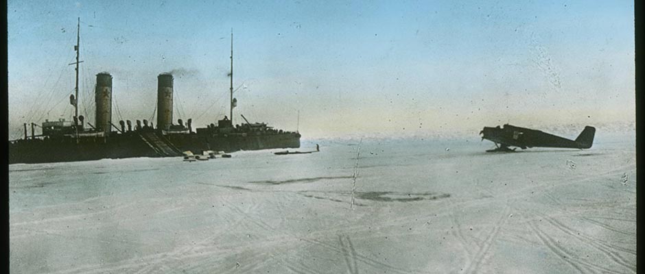
the icebreakers, the Taimyr transferring pro c v isions and a shed for
her hydroplane to the coast. As the livestock brought from Vladivosto k
was nearly consumed, a rationing scheme was drawn up, but the outlook
was far from dark , as reindeer and partridges had been sighted on shore
Various necessary repairs were begun and contrivances were rigged up
to permit the taking of scientific observations: meteorological,
hydrological, astronomical, etc. Meteorological observations in–
cluded studies of the upper layers of the atmosphere by means of
flying kites equipped with a meteograph. In order to keep the members
of the expedition in good health, games and exercises in the open were
arranged, and the long evenings were filled with instruction courses
and lectures on popular subjects.The expedition fared relatively well during the winter until the
end of February when a death occurred - that of Lt. A.N. Zhokhov
of the Vaigach . A month later, the fireman Ladonikhov died of
012 | Vol_X-0493
RHE cont.
appendicitis. However, a round of fresh activities soon brought
cheer and new expectancy. Mild weather came with April and on the
15th, a first snow-bunting was sighted on the ice. From the 22nd onwar
onward the sun ceased to sink below the horison. During May Sverdrup
arrived for a visit and a number of land excursions were inaugurated.
An overland party was despatched to Golchikha Village on the Yenisei,
which fell in with a relief party from Krasnoiarsk, scheduled to esta–
blish a radio station on Dickson Island. Excursions were made to
Oscar Peninsula and the adjoining shores. Survey work were carried
out by Lts. A. Lavrov and N. Evgenov and the able cartographer,
Lt. Neupokoev. They discovered that Haffner Fjord was closed and
had no water communication with Faddei Bay on East Taimyr. A frozen
mammoth was found by one of the shore parties. In order to speed up
excursions on land, the expedition converted their hydroplane into
an aero-sledge.The highly valuable scientific work of the expedition came to
an end toward the beginning of August 1915, when openings appeared in to
the surrounding ice. After heavy maneuvering, the vessels finally
broke loose, passing Cape Vilda on August 28. The following day, they
met the Eclipse which had managed to free herself two weeks before
and which was bringing coal to them from Dickson Island. Together
the three ships proceeded to Dickson Island, where the expedition
found the wireless station well advanced. The Vaigach thbnce went to
the mouth of the Yenisei River to pick up the team which had left for
Golchikha earlier in the season. The ships then left for Arkhangelsk,
the icebreakers passing through Yugor Strait, the Eclipse cho o sing the
way through [Matochkin Shau?]. On Sept e mber 14, the
013 | Vol_X-0494
RHE cont.
vessels anchored at Cape Kanin, awaiting arrival of the ice-cutter
Brus which was to escort them thro u gh a German minefield in the
eastern part of the White Sea. On the 16th, all three ships
entered Arkhangelsk where they met with much acclaim and a cere–
monious reception.The mass of scientific data resulting from the Russian
Hydrographical Expedition was were never fully evaluated due to the
war and the revolution, but the major achievements of the expedi–
tion stood out at once. and They may be summarized as follows: 1) consi–
derable cartographic work was done along the entire coast from Cape
Dezhnev to the mouth of the Yenisei River which permitted material
corrections of existing maps; 2) soundings were made along the entire
route and currents and ice conditions were determined in many parts
of the Chukotsk, East Siberian and Laptev seas; 3) sailing directions
were prepared for the eastern Arctic as far as the Lena delta, and the
establishment of commercial navigation from t V ladivostok to the
Kolyma mouth was made possible; 4) Severnaia Zemlya and a number of
small unknown islands [ ?] put on the map; 5) the main goal of
the expedition attained - the forcing of the Northeast Passage
from east to west. In all, a vital chapter had been added to
the history of Arctic exploration.
014 | Vol_X-0495
RHE cont.
Bibliography:
1. Breitfuss, L. "Zur Frage ueber den sibirischen Seeweg nach Osten".
Petermanns Mitteilungen Vol.50, 1904. pp. 285-290. Gotha,
J. Perthes Verlag.2. Breitfuss, L., Die Erforschung des Polargebietes Russisch-Eu-
rasiens. Petermanns Mitteilungen. Ergaenzungsheft Nr.188.
pp. 68-74. Gotha, J. Perthes 19253. "Vilkitski's North-East Passage, 1914-15." (Abridged translation
form a narrative of the above voyage by L.M. Starokadomski, pub–
lished in Russian at Petrograd in 1916.) The Geographic Jour-
nal . vol. LIV, no. 6. December 1919 pp. 367-375. London,
The Royal Geographical Society4. Fransehe, N.A., "The Siberian Sea Road". The Geographical Review.
vol.XV. no. 3. July 1925. pp. 367-398. New York, American
Geographical Society.5. [Starokadocki, L.M. "Ekepeditaic?].... 1910-15
[ ?] Moscow 1946Felizia Seyd