-
Geology of Svalbard
Encyclopedia Arctica Volume 1: Geology and Allied Subjects
Unpaginated | Vol_I-0439
EA-I. (Anders K. Orvin)
GEOLOGY OF SVALBARD
CONTENTS
Page Younger Silurian and Devonian 7 Earth Movements in Upper Devonian Time 10 Carboniferous and Permian 10 Triassic 12 Jurassic and Cretaceous 13 Volcanic Activity in Cretaceous Time 15 Tertiary 16 Tertiary Foldings, Overthrusts, and Faults 18 Quaternary Period 22 Quaternary Volcanoes 29 Bibliography 30
Unpaginated | Vol_I-0440
EA-I. Orvin: Geology
MAPS
This manuscript was accompanied by two colored geological maps
of Svalbard and Bjørnøya. Because of the high price of reproducing
such maps, only a few submitted will be used in Volume I. The
selection of the number of these maps will be determined by the
publisher, and the choice of those used should be made in conjunction
with a representative of the publisher. All maps are, therefore, being
held at the Stefansson Library until a selection can be made.
001 | Vol_I-0441
EA-I. (Anders K. Orvin)
GEOLOGY OF SVALBARD
The geological exploration of Svalbard was, in the last half of the
nineteenth century, carried out chiefly by Swedish geologists, but from
1906 the leadership was taken over by the Norwegians. Geologists from
other countries have also participated in this work.Geologically, Svalbard is one of the most representative and interest–
ing groups of islands, not only in the Arctic, but in the whole world. On
these rather small islands nearly the whole sequence from P p re-Cambrian to —
older Tertiary is preserved. During long periods of subsidence, thousands
of meters of gravel, sand, clay, mud, and calcareous material have been
deposited and transformed into sedimentary rocks, some containing an abund–
ance of fossils of ancient plants and animals, especially marine and littoral,
but also of continental origin. At different times these sediments have been
folded and raised above sea level. We find them now well exposed where
they have been cut through by valleys and glacier erosion. It is believed
that Svalbard has passed through almost all the different stages now found
in warmer countries.
002 | Vol_I-0442
EA-I. Orvin: Geology
As late as in older Ter t iary, great forests grew in a climate about the ✓
same as that of southern Europe today; yet, at present, the Svalbard Islands
are more than half covered by ice, and not for the first time in their history.
Early Cambrian tillites or petrified moraines indicate that a very extensive
glaciations took place in that early period. In the distant future Svalbard
may again sink into the sea or be covered by new forests.In Svalbard there is a distinct difference between the pre-Downtonian
highly metamorphic and the younger nonmetamorphic sediments. The older group
is known under the name of the Hecla Hoek Formation , a name originally given
by A.E. Nordenskiöld to some metamorphic sediments at K H eclahuken in northern ✓
Spitsbergen, but later used for all pre-Downtonian sediments. The name Hecla
Hoek thus includes a very long period, probably sediments from Algonkian to
Silurian.The highly metamorphic rocks and granites in the northern part of Spits–
bergen were originally referred to as Archean, but the great eruption of gra–
nites was later found to be of Caledomian age. In fact , it is doubtful if ✓
any Archean rocks exists in Svalbard. The Hecla Hoek sediments are found on
Bjørnøya (Bear Island), along the western coast of Vestspitsbergen, on Prins
Karls Forland, farther east of Wijdefjorden, and in Nordaustlandet (Northeast
Land).
003 | Vol_I-0443
EA-I. Orvin: Geology
Determinable fossils have been found at two points only, on Bjørnøya
and at Kapp Sparre on Nordaustlandet. Both localities are probably situ–
ated on the outskirts of the Caledonian mountain chain. On Bjørnøya, Holtedahl
found fossils from Lower and Middle Ordovician. He presumes the oldest dolo–
mites on Bjørnøya to be of early Cambrian age. The total thickness of the
Hecla Hoek sequence on Bjørnøya is about 1,200 meters. At Kapp Sparre in
Nordaustlandet, Kulling discovered brachiopods of Lingulella and Obolus
species, apparently of Lower Cambrian age. They were found uppermost in a
series of 3,600-4,300 meters, or more, consisting in the lower part chiefly
of sand l y and argillaceous sediments, in the middle part of thick dolo–
mites, and in the upper part of alternating beds of dolomites, shales, and
some sandstones. About 800-850 meters below the fossil horizon, he found a
tillite, probably inaugurating the Cambrian. The entire sequence rests on
porphyries of the so-called Kapp Hansteen Formation . The greater part of the
sequence is probably of Algonkian and Cambrian age and thus partly corresponds
with the oldest dolomite on Bjørnøya. The porphyries may be of Archean age.
The tillites are of especial interest; they indicate an enormous and extensive
glaciations. The total thickness of Cambrian and older beds in Nordaustlandet
together with the Ordovician dolomite and limestone on Bjørnøya runs to
about 5,000 meters. Contemporaneous tillites have also been found in several
other localities, like Central Asia, China, Africa, Australia, etc.
004 | Vol_I-0444
EA-I. Orvin: Geology
In Ny Friensland (New )Friesland), Odell estimated the thickness of the ✓
Hecla Hoek sediments, mostly dolomites and limestones, to be not less than
10,000 meters. Kulling, however, explains the great thickness as caused by
repetition due to folding and possibly folding overthrust, and he believes
that this sequence represents only a part of the sequence in Nordaustlandet.
The Hecla Hoek in Ny Friesland and east of Wijdefjorden thus probably belongs
to the Lower Cambrian and Algonkian.In the northwestern corner of Vestspit z s bergen and on the eastern side ✓
of Wijdefjorden, the Hecla Hoek sediments are ver y strongly metamorphosed. ✓
Gneiss, amphibolites, mica schist, and coarse crystalline limestone and dolo–
mite are found mixed with granites and pegmatite dikes. Along the west
coast of Vestspitsbergen, the Hecla Hoek sediments have a strike roughly
parallel to the coast. It is practically certain that all the rocks along
this coast are younger than the Archean.On the northern side of Kongsfjorden, there is a great syncline with a
very thick crystalline limestone. At a depth of about 2,500 meters,
quartzites, phyllites, and mica schists reappear, as they do on Brøgger–
halvøya, south of Kongsfjorden, together with dolomites and another series
of mica s c hist. ✓Between Engleskbukta and Isfjorden there are similar rocks. A thick
limestone forms the conspicuous mountain Alkhornet on the northern shore of
Isfjorden, and at St. Jonsfjorden, a tillite containing blocks of granite
and Alkhorn - limestone has been observed. It is probably the same tillite —
horizon s as in Nordaustlandet. ✓
005 | Vol_I-0445
EA-I. Orvin: Geology
On Prins Earls Forland and between Isfjorden and Sørkapp
(South Cape), the greater part of the sediments are limestones, dolomites,
phyllites, quartzites, and clay slate, but garnetiferous mica schist, mica - ✓
schist, and marble are also present. In a small area north of Hornsund,
different basic eruptives occur, and in one place we find transitions
from quartzite into granite. Only two tubeline fossil fragments have
been found in a partly dolomitized limestone on the southern shore of
Hornsund, east of G [ ?] . Two different, very thick conglomerates
occur between Bellsund and Sørlapp, indicating periods with extensive
erosion. Probably both represent tillites. The younger, found over the
whole peninsula between Bellsund and Dunerbukta, is certainly a tillite,
probably contemporaneous with the tillites on Nordaustlandet.The great difference between the pre-Downtonian (or Hecla Heck)
and the younger sediments is due to the Caledonian mountain folding,
changing Svalbard from a geosynclinals area covered by the sea to part of
a mountainous country extending from Svalbard southward to Norway, and
northwest, perhaps, to Greenland. Deep valleys were out into the country,
and erosion went on until deposition of the Downtonian sediments took
place on the roots of the Cal de ed onian mountain chain, consisting of strongly
folded overthrust, faulted and metamorphic sediments, together with gneiss
and different eruptives.
006 | Vol_I-0446
EA-I. Orvin: Geology
Of the igneous rocks intruded during the Caledonian folding, two
main types of granites are known from northern Svalbard. One is a gray,
strongly foliated granite; the other is red, and not foliated. The
gray granite occurs at many localities: Dei Sju Isfjella, Magdalenefjorden,
Danskøya, Amsterdamøya, Norskøya, the coast from Raudfjorden to
Smeerenburgfjorden, in the Newton massif, and in the northern part of
Nordaustlandet. The granite is frequently interstratified with gray
gneiss, and many pegmatite dikes occur along the margin of the granite.
It is mostly biotite granite, but amphibole granite also occurs.The G g ray granite is probably a paragranite, formed by granitization ✓
of Hec k la Hoek sediments under hydrostatic pressure (anatexis of Sederholm) ✓
when the Cal de ed onian folding had terminated. Only th i u s is it possible to ✓✓
explain the gradual transition from typical Hec k la Hoek sediments to ✓
granites, and transition stages which have the structure of sediments but
otherwise the composition and appearance of gneiss and granite.The red granite is apparently younger and belongs to the last phases
of the folding. It is distributed west of Raudfjorden, covers a large
area west of Liefdefjorden, and thence southward into the inland east of
Kongsfjorden. It also occurs in the Tsjernysjo y v , massif in Ny Friesland, ✓
farther in the central part of Nordaustlandet, and at Isispynten.
Diorites are known from Smeerenburgfjorden, Isispynten, and the northern
part of Storøya.
007 | Vol_I-0447
EA-I. Orvin: Geology
Younger Silurian and Devonian . The oldest sediments deposited on
the ruins of the Caledonian “mountains” are of younger Silurian and
Devonian age. They occur between Isfjorden and the north coast of
Vestsp l itsbergen, limited toward the east by a great fault line along ✓
Wijdefjorden and Billefjorden and toward the west by a fault line along
the western shore of Raudfjorden. A smaller area with Devonian sediments
is situated in the inner part of Hornsund. The total thickness of these
sediments amounts to 5,000-6,000 meters, apparently without any hiatus.
The lowermost Red Bay Series (Raudfjord Series) has been divided into
the lower Fra e nkelryggen Division of Downtonian age and the upper Ben Nevis ✓
Division of Dittonian age. The whole series should perhaps be referred
to the Devonian rather than to the U u pper Silurian. The Fra e nkelryggen ✓✓
Division is built up by 500-600 meters of coarse breccias and red conglo–
merates, approximately 200 meters of yellow-white, course, crossbedded
sandstone, and the uppermost several hundred meters, red and green sand–
stones with ostracoderms. Fish fossils occur, among which are forms of
Poraspis, Anglaspis, Dinaspis , and minute species of Pteraspis primaeva .
A horizon containing plant remnants of Pteridophytes is also present.
Cephalaspis , Ctenaspis , and others occur in both divisions. The Ben
Nevis Division consists of about 900 meters grayish-green and partly red
sandstones with sandy shales, containing fossils of Pteraspids,
D C ephalaspids, and other scleroderms. Homaspis is an excellent guide ✓
fossil. Different mussels, as Carditomantea and Pterina are also present.
The fauna seems to have lived partly in brackish, partly in salt water.
008 | Vol_I-0448
EA-I. Orvin: Geology
The Wood Bay Series (Woodfjord Series), which follows, is divided
into three divisions. The lowermost Kapp Kjeldsen Division, belonging
to the p l ower part of the Lower Devonian, is built up of 1,200-1,500 ✓
meters of brown-red, sandy sediments, and the uppermost Stjørdalen
Division of about 500 meters of purple-colored, fine-grained, sandy
layers with a 20- to 40-meter-thick yellowish-gray sandstone on the top.
The fauna of the Wood Bay Series consists mostly of Østracoderms, a A rthrodirs, ✓
and Crossopterygians. Of the O Ø stracoderms, the Pteraspids are represented Ø ✓
by such forms as Pteraspis , Giganthaspis , and Doryaspis . The last-mentioned
is a perfect guide fossil for the Lykta Division. Cephalaspids are also
represented by different species. Boreaspis appears in a great number of
species. Arthrodirs Phlycta e naspis and Monaspis occur in different forms, ✓
and are probably Lower Devonian.Above this occurs the Grey Hoek Series (Gr a å huk Series), Lower or accent ✓
Middle Devonian, with about 1,000 meters of gray sandy shales and some
beds of sandstone. This series contains Mollusca such as Ctenodonta ,
Montanaria , Nucula , Myalina , and Avicula . Arthrodirs Phlyctaenaspida are
represented by Hugenaspis , Mediaspis , Arctolepis , and Monaspis , and
Petalychtida by Lunaspis . Plant fossils such as Psilodendron and
Hostimella are also present, and are Lower or Middle Devonian.
009 | Vol_I-0449
EA-I. Orvin: Geology
The uppermost series in northern Spitsbergen is the Wijde Bay Series
(Wijdefjord Series) consisting of about 500 meters of gray sandstone and
gray-to-black shale, with mussels, Østracoderms, and fish fossils such as
Asterolepis , Heterostius , and Homostius . The beds at Wijd e fjorden are of ✓
Middle Devonian age and marine origin, whereas the uppermost beds at
Fiskekløft e a in Mimerdalen, west of Billefjorden, are from upper Middle ✓
Devonian and continental. Høeg has described plant fossils that occur
here, among them Actinopodium, Prototaxis, Enigmophyton, Platiphyllum ,
and Bergeria .On Bj o ø rnøya the above-mentioned series are missing. Here, Upper ✓ accent
Devonian sandstone and shales with coal seams rest unconformably on Hecla
Hoek rocks. It seems to have had a rich vegetation and a humid, subtropical
climate quite different from the dry climate in Downtonian and Lower
Devonian. On Bjørnøya the lowermost bed, a conglomerate, contains shells of
Holoptychius and Asterolepis , and, in the higher horizons, plant fossils of
Archaeropteris, Cyclostigma, Rhizomopteris, Sphenopteris, Sphenophyllum,
Sigillaria, and Lepidodendron . This vegetation is closely related to the
L l ower Carboniferous vegetation on Bjørnoøya. ✓
010 | Vol_I-0450
EA-I. Orvin: Geology
Earth Movements in Upper Devonian Time . Before the Carboniferous
sediments in Spitsbergan were deposited, a general elevation of the land
took place under faulting and folding. Erosion set in through a long
period so that Hecla Hoek rocks again became exposed throughout consider–
able areas. Devonian sediments were preserved only in a big G graben raben between ✓
north and south faults. In the north and the G g raben has a width of about ✓
50 K k ilometers. It is bordered on the east side by a big fault along ✓
Wijdefjorden, across Pyramiden, Billefjorden, and Sassenfjorden with
direction toward Kvalv a å agen on the west side of Storfjorden. This tectonic ✓ accent
disturbance is known as Svalbard Folding , the upward limit being fixed by
the unconformity below the Upper Devonian of Bjørnøya, where the L l lower ✓
Carboniferous succeeds the Devonian, apparently conformably.Carboniferous and Permian. These systems, in Svalbard, are repre–
sented by continental sediments from the L l ower Carboniferous, and marine ✓
sediments from the M m iddle and U u pper Carboniferous and from L l ower Permian. ✓ ✓ ✓
The subtropical climate already manifested in the Upper Devonian of
Bjørnøya prevailed through the L l ower Carboniferous time, when great ✓
thicknesses of sandy material were deposited under slight subsidence of
the whole area. Coal seems found in the L l ower Carboniferous indicate ✓
extensive subtropical forests. All Lower Carboniferous sediments are to
be regarded as continental and littoral, deposited in partly fresh and
partly brackish water. Such sediments are found on Bjørnøya, along the
western coast of Vestspitsbergen from south of N H ornsund to Kongsfjorden, ✓
and in Billefjorden where coal seems are worked by the Soviet Russians in
Pyramiden. The thickness of the L l ower Carboniferous sandstones is up to ✓
about 1,000 meters. In the lower part, several layers of black shale
contain plant fossils of Adiantites , Lagospermum, Lepidodendron ,
Sphenopteridium , and others.
011 | Vol_I-0451
EA-I. Orvin: Geology
At the end of the L l ower Carboniferous block faulting under partial ✓
elevation of the land took place, which was followed by erosion before the
sea again transgressed on the land, and during the M m iddle Carboniferous ✓
littoral deposits of conglomerates, sandstones, and calcareous sediments
were laid down on an uneven surface. Such cong l omerates showing a red ✓
color are found on Bjørnøya, at Hornsund, Bellsund, Kongsfjorden, and
Blillefjorden. The thickness of the M m iddle Carboniferous Bjørnøya is ✓
470 meters, in Spitsbergen less. A n extensive subsidence in the entire ✓
Svalbard area followed into the Permian period, and the thick U u pper ✓
Carboniferous limestones were deposited. The sedimentation was interrupted
several times by various causes.In Spitsbergen, beds of anhydrite and gy m psum occur in the M m iddle ✓ ✓
as well as in the U u pper Carboniferous sequence, indicating lagoons and ✓
very dry climatic conditions. The U u pper Carboniferous Cyathophyllum ✓
Limestone , about 450 meters thick, is present in the central and north–
eastern parts of Spitsbergen. In the upper part, two beds of limestone,
Cora Limestone and Schwagerina Limestone, are packed with marine fossils,
brachiopods, corals, sponges, etc. in the outer part of Isfjorden, the
sequence between the two limestones consist of chert and cherty limestones,
which seem to be missing farther east.Above the Schwagerina limestone, follows a series of cherty limestones
and chert with many horizons containing silicified fossils of L l ower ✓
Permian age. The uppermost Permian bed, in the northern and eastern part,
is an up to 50-meter thick glauconitic sandstone. On Bjørnøya there are
no Permian sediments, but the U u pper Carboniferous Spirifer Limestone ✓
(Schwagerina Limestone) is 120 meters thick and rests unconformably on
older sediments.
012 | Vol_I-0452
EA-I. Orvin: Geology
Triassic . The U u pper Permian is, as far as we know, missing in ✓
Spitsbergen. In the southernmost part of Vestspitsbergen some faulting and
erosion took place before the Triassic beds were deposited. An almost
complete succession of Triassic sediments is present in the southern part
of Vestspitsbergen, on Edgeøya, and Barentsøya. The lowermost littoral
or marine beds of sandstone, calcareous sandstone, marl, and limestone are
probably of eo-Triassic age. In the Sassendalen, the thickness is 150 meters;
in the Festning section at the outer part of Isfjorden, 245 meters ; at ✓
Bellsund, 400-500 meters; and at Hornsund, 180 meters. These beds are
followed upward by black shales and black-gray, partly sandy marls from
the younger part of the Lower Triassic to Middle Triassic, with a thickness
of less than 100 to more than 400 meters. These sediments contain many
remains of reptiles, fish fossils, ammonites, bivalves, coprolites, etc.,
indicating a prolific marine life. Then follows a smaller series with
conspicuous sands t ones, shales, etc.,; it is partly continental with plant ✓
fossils. Even streaks of coal have been observed, especially in the
eastern part of Svalbard. The uppermost part of the Triassic is again
marine, and consists of alternating calcareous and arenaceous beds, about
250 meters thick and of Upper Triassic age. The total thickness of the
Triassic sequence is 1,150 meters at Festningen, 500-600 meters at Bellsund,
north of Hornsund about 350 meters, and in Kistefjellet, near Sørkapp,
174 meters. The early average temperature was rather warm.In Kistefjellet, and probably also on Bjørnøya, the Upper Triasssic
beds rest on Hecla Hoek Carboniferous rocks, showing that an unconformity
exists below these beds.
013 | Vol_I-0453
EA-I. Orvin: Geology
Jurassic and Cretaceous . In U u pper Lias the sea encroached upon the ✓
land, and a widespread conglomerate was deposited on Triassic sediments.
In Callovian a large depression took place and lasted well into the
Cretaceous period. Marine deposits from this submersion are found over
the southern part of Vestspitsbergen. The sequence is rather monotonous,
containing chiefly marl shales with some clay shales and calcareous
concretions, and thin limestones along with some sandy beds, clay ironstone,
and ferrugineous carbonates. The thickness is 400-600 meters. Many
horizons contain a fairly rich fauna of ammonites and lamellibranchiates
of which many are aucellas. The sequence is often called the Aucella Shale.
Middle Callovian is apparently lacking, but U u pper Callovian, Kim m eridg ian e , ✓ ✓
and Lower Portlandian are present. The upper half of the Aucella Shale
is of Lower Cretaceous age with Valanginian containing the Volga horizon
lowermost.
014 | Vol_I-0454
EA-I. Orvin: Geology
Above the Aucella Shale we find continental sandstones and shales
of U u pper Valanginian, Hauterivian-Barr e é mian age, further marine, sandy ✓
beds from Aptian being the youngest Cretaceous in western Svalbard. In
the eastern part Albian beds also occur, but all younger Cretaceous
sediments were removed by erosion before the Tertiary. Some horizons
of the continental Cretaceous contain large amounts of plant fossils of
which Elatides , Pityophyllum , and Gingko are profusely represented.
A coal seam also occurs, which has been worked at Advent City in
Adventfjorden. But the greater part of the division consists of sandy
sediments with a conspicuous sandstone, the Festning Sandstone. West
of Grønfjorden the division is about 150 meters. In the eastern part of
Vestspitsbergen the continental development is more pronounced. The
S s andstones are partly conglomeratic with current bedding. Above the ✓
Festning Sandstone, follow shales, sandstones, and a tuff conglomerate
with pieces of wood and a bed of clay ironstone. Another conspicuous
sandstone is termed Shore Sandstone. The transgression of the sea in
Aptian is marked by a quartz conglomerate. The continental series on the
east coast is, according to Obruche r v , about 200 meters, and the above–
lying marine division is up to 790 meters, making a total thickness of
the Jurassic and Cretaceous of about 1,500 meters. Jurassic and
Cretaceous sediments are distributed in the southern part of Vestspitsbergen
and are also present on Hopen and Kong Karls Land. The development is
boreal and resembles that of the Soviet Arctic. The deposits have the
character of shallow water deposits found near coasts. The climate must
have been rather warm, with a distinct difference between summer and
winter. Gothan has found year rings in tree trunks from these periods.
015 | Vol_I-0455
EA-I. Orvin: Geology
Volcanic Activity in Cretaceous Time . Dikes of diabase occur in the
sediments of Vestspitsbergen up to and including the Triassic. Sheets of
this rock can be traced for kilometers before they cross the bedding or
taper out. At Hinlopenstredet coarse - grained dolerite is found at ✓
several points. On Kong Karls Land, Nathorst found basalts younger than
the continental Cretaceous, but, as the underlying sediments also contain
particles of basalt, it seems most likely that at least two eruptions have
taken place. It is thus not certain that the basalts on the east coast and
the diabase on the west coast are contemporaneous. On the north coast,
lava flows resting on Devonian rocks are exposed in the Cretaceous
peneplain. Goldschmidt has described them as typical plagioclase basalts
probably belonging to the same eruption as the basalts of Kong Karls land
and Franz Josef land.
016 | Vol_I-0456
EA-I. Orvin: Geology
Tertiary . The youngest sediment of Svalbard are of older Tertiary
age. They rest on Lower Cretaceous sediments in southern Spitsbergen, on
Permian rocks at Kongsfjorden, and on Hecla Hoek rocks in a few places
along the western coast of Vestspitsbergen. The lowermost part, the
Lower Light Sandstone Series , consists of gray to yellowish-gray sand–
stones with layers of greenish fissile sandstones, shales, and two to four
coal seams near the base. These seams are worked at Kongsfjorden,
Adventfjorden, Colesbukta, Grønfjorden, and Braganzav a å gen. The beds have ✓ accent
continental and lake development, but some horizons contain marine bivalves,
showing periodic encroachments of the sea. The basal bed is conglomerate.
The thickness of this series is from 1 0 1 0 to 130 meters. This sandstone ✓
series is followed upward by the Lower Dark Shale Series , 60-130 meters thick.
It consists of a blackish-gray clay shale weathering into angular, often pris–
matic pieces. In the upper pat, marine bivalves have been found at Colesbukta.
The succeeding division consists of medium-grained, greenish sandstone, and
is called the Green Sandstone Series . This sandstone often forms plateaus,
below which numerous talus cones occur. In the eastern part of the Tertiary
area there is no distinct boundary toward the shale below. Marine fossils
have been found in the upper part. The thickness is 175-250 meters. The
next series upward is the marine Upper Black Shale Series , consisting
entirely of black, fissile clay shale weathering into small angular bits.
The shale forms smooth slopes and often cone-shaped summits, rising from
the plateaus of the green sandstone. The thickness varies from 240 to
about 300 meters. It contains marine bivalves and some pebbles of chert.
017 | Vol_I-0457
EA[?]I. Orvin: Geology
The Flaggy Sandstone Series , which follows, was deposited in shallower
water and consists of alternating beds of black clay shale and gray to
greenish-gray sandstone, which contains badly preserved marine bivalves,
worm tracks, ripple marks, some plant remains, and even streaks of coal.
Nordenskiold estimated the thickness at about 200 meters, but it is difficult
to fix the line between this series and the uppermost series called the
Upper Plant-bearing Sandstone Series , which consists of light gray and
greenish, usually fine-grained sandstones and slaty sandstones with clay
ironstone, clay shale, marly shale, and a number of thin coal seams. The
thickness now left by erosion exceeds 600 meters. No marine fossils have
been found, but the coal seams and the abundance of plant fossils and
petrified wood show that the sediments are of continental origin. The
fossiliferous strata are frequently somewhat ferrugineous, and seem to
have been silted up in lakes. It looks as if the area has undergone a
slow subsidence just l k eeping pace with the sedimentation. ✓ —The greatest total thickness of the Tertiary in the central syncline
is nearly 2,000 meters. The coal seams are undoubtedly of autochthonous
origin and the immense distribution of Equisetum shows the presence of vast
moors where this species dominated. The climate in older Tertiary has has —
been estimated at about 20°C. higher than it is now, similar to the climate
of southern Europe today. From the bivalves, Ravn has judged the five
lower divisions to be of Paleocene and probably Eocene age. The uppermost
series may be younger, but probably it is also of older Tertiary age.
018 | Vol_I-0458
EA-I. Orvin: Geology
Tertiary Foldings, Overthrusts, and Faults. In t T tertiary time strong ✓
earth movements again took place. The present aspect of Spitsbergen is
largely due to these movements. Along the western part of Vestspitsbergen
the sediments were folded and partly overthrust. This folding is very
conspicuous from Kongsfjorden to Sørkapp. The folded strata form long
ridges separated by glaciers. Particularly the U u pper Carboniferous and ✓
Permian siliceous limestones and cherty rocks in many localities form
sharp ridges and precipitous crags. Eastward, the mountains are more of
the plateau type and frequently rise in steps, with an appearance of some
huge building, as Templet, west of the entrance to Tempelfjorden. In two
small areas, one at Forlandsundet, the other at Kapp Lyell on the south
side of Bellsund, Tertiary beds rest directly on Hecla Hoek rocks. These
beds contain an abundance of the Sequoia langsdorfii not found in the
lower part of the Tertiary sequence elsewhere in Svalbard, but common in
the Upper Plant-bearing Sandstone Series. Consequently, these Tertiary
beds must be supposed to be contemporaneous with the uppermost series
elsewhere. This fact seems to be explained only by a fault line older
than the Upper Plant-bearing Sandstone Series, west of which all the
post-Caledonian sediments were eroded away before this series was deposited.
The Tertiary folding in younger than all the Tertiary sediments in Svalbard,
as all of these have taken part in the folding. For this reason the age
cannot be fixed, but it may be assumed that the folding took place in
Miocene time.
019 | Vol_I-0459
EA-I. Orvin: Geology
The folding zone is especially well exposed where it crosses
Isfjorden, Bellsund, and Hornsund. The greatest width is found on the
northern shore of Isfjorden. At Kongsfjorden, where there are also
overthrusts, the trend of the folding zone is more westerly and runs out
into the sea. The southward continuation is unknown; it is difficult
to ascertain whether this folding has been active on Bjørnøya. The folded
zone is, in fact, broader than seen from the younger beds today, because
the post-Caledonian sediments have been removed by erosion in the west.
Within the Hecla Hoek areas the Tertiary movements are difficult to trace,
unless they caused a shift in the trend of the Caledonian strike as is the
case on Brøggerhalvøya, south of Kongsfjorden. Under the folding - pressure ✓
the western part rose, and the whole younger sequence was turned over
toward the east. Consequently, we now find the strata inverted in the east–
ern part of the folding zone. In several places, such as Brøggerhalvøya,
on the southern side of Van Kaulenfjorden, and at the head of Hornsund,
the pressure also resulted in overthrusts. It is possible that the
folding zone reached father west than the present coast. In the eastern
part of Svalbard the younger sequence is practically undisturbed, with
the exception of the syncline in the central part of Vestspitsbergen and
an anticline that forms Barentsøya and Edgeøya.The Tertiary folding in Svalbard comes within the category
Faltengebirge (fold mountains) of Hans Stille. Metamorphism proper did
not take place, but the sediments become indurated and partly squeezed.
In the eastern part of Svalbard the sediments are generally unconsolidated,
and loose sands occur in places. This is never the case in the western
part, nor are the fossils here so well preserved as in the east.
020 | Vol_I-0460
EA I. Orvin: Geology
After the folding had terminated, the folding zone collapsed along
great faults roughly parallel to the folding axis, partly following older
fractures. In several spots, as from Kongsfjorden to Isfjorden, at
Midterhuken in Bellsund, at Reinodden east of Recherchefjorden, in the
inner part of Hornsund, and at Sørkapp, one can directly observe how the
faults cut through already folded strata. We are led to believe that the
horizontal pressure kept the folded area in a kind of bend so long as the
forces were acting. When they diminished, the folded zone partly broke
down. In Forlandsundet, a graben was formed, and here Tertiary sediments
are still preserved with high mountains of Hecla Hoek rocks on either side.
The big eastern fault is certainly the same fault that is found at Bellsund,
where the western part has sunk more than 3,000 meters. At Reinodden the
inverted part of the main fold was cut by this fault with the result that
the L l ower Carboniferous-Cretaceous sequence no s w occupies an inverted ✓ ✓
position surrounded by Hecla Hoek rocks.
021 | Vol_I-0461
EA. I. Orvin: Geology
A great fault is also seen cutting the fold from the inner part of
Hornsund to the southern promontory of Vestspitsbergen. The old Devonian
fault along Wijdefjorden and southward , across Billefjorden and Sassenfjorden ✓
broke up to the inland east of Van Mijenfjorden. Another fault runs from
Lomfjorden to Agardhbukta, in the eastern part of Vestspitsbergen. Big
landslips are common in certain parts of the sequence, where massive sand–
stones overlie thick, soft shales. This has in some cases, especially as
regards the stiff Cretaceous sandstones resting on the soft Aucella Shale,
led to misinterpreting these landslips as ordinary faulting.Some of the fjords and straits of Spitsbergen owe their origin to
faulting, as Forlandsundet, Kongsfjorden, Wijdefjorden, and possibly
Hinloponstretet, whereas other fjords, for example, Trygghamna and
Grønfjorden, are due to the trend of the folding. From the presence of
large submarine valleys along the west coast of Spitsbergen and in the
bottom of the Barents Sea, we must conclude that these areas at one time
had a level about 500 meters higher than at present. This upheaval
probably took place in later Tertiary time, when the land surface was
subject to a large amount of erosion, until it again became submerged
and the Svalbard islands were separated from the land to the south and
east by shallow sea. This subsidence was due to the large ice cover creep–
ing upon the land with the beginning of the Quaternary period.
022 | Vol_I-0462
EA. I. Orvin: Geology
Quaternary Period . At the beginning of the Quaternary period,
Svalbard must have been a mountainous land, connected with Scandinavia,
Russia, and Novaya Zemlya, with peaks rising to 2,000 to 3,000 meters.
In U u pper Tertiary the climate had become colder, and with the Quaternary
time the first glaciations took place over the whole area, including
Scandinavia, the present Barents Sea, and the Svalbard islands. Gradually
the land was covered by ice and subsided under the pressure of the heavy
ice sheet. We know very little about this first glaciations or the follow–
ing glaciations and interglacial periods in Svalbard, because nearly all
evidence of their activity, as shore lines, deposition of terraces, moraines,
etc., has been removed by the last great glaciations. We do not know to
what extent the land was pressed down, but some remnants of high shore
lines may be due to subsidence older than the last glaciations. Such
shore lines have been found in Hilmarfjellet, north of Sørkapp, at 255
and 355 meters above sea level; in Dumskolten, east of Sørkapp, at 210
and 340 meters; and on Kong Karls Land, where boulders occur at 273 meters
and a boulder beach at 218 meters above sea level. These marks may, however,
also be due to old rivers or ice-dammed lakes.
023 | Vol_I-0463
EA. I. Orvin: Geology
It is not very likely that there has been any land connection
between Svalbard and the continent since the first glaciations took place.
Anyway, we know that the last glaciations was isolated in Spitsbergen as
well as on Bjørnøya. The greatest subsidence from the beginning of
Quaternary time was probably about 800-900 meters, of which about 500
meters are still below sea level. All deposits of terrace material,
moraines, raised gravel beaches, and erratic blocks, and also shore lines
seen in Svalbard at present, are from the last glaciations or younger.
Most of the fjords are old trough valleys formed by the glaciers at
different times during the Quaternary period, partly since these valleys
were drowned. Where the glaciers passed more resist e a nt rocks, we now find ✓
thresholds across the fjords. This is the case, for instance, where the
Permian cherty rocks cross the outer part of Isfjorden and where they form
Akseløya across the mouth of Van Mijenfjorden. In some cases the smaller
depths in the outer parts of the fjords are due to frontal moraines
deposited at different stages of the glaciers.One of the most conspicuous forms from the Quaternary is the great
strand flat, surrounding the west coast of Spitsbergen, and reaching, at
places, about 65 meters above sea level. The formation of this strand flat
is due to marine abrasion, probably during more variations of the sea level.
It may, however, hardly be doubted that the ice has also taken part in this
work. Today, we can see how the drift ice and the ice foot work on the land.
Where glaciers of the Malaspina type have spread over the strand flat, we
find an undulating surface with shallow lakes in depressions carved out in
the softer rocks.
024 | Vol_I-0464
EA. I. Orvin: Geology
Glacial striae are not common in the little-resistant sediments of
southern Svalbard, but one can see that the last ice sheet moved southwest–
ward on the west coast and southward on the east coast. The ice reached
from Nordaustlandet over Barentsøya and Edgesøya and filled Storfjorden.
The elevated shore lines along the inner part of the strand flat are
mostly blurred by solifluction from the nearby hillsides.In most localities 65 meters seems to have been the upper limit of
the sea, since marine Mollusca have not been found above this height. In
portions of the outer part of the fjords some steps in the ground, up to
150 meters above sea level, may be old shore lines. It is possible that
the sea was at these levels when the valleys were still filled with ice.
That is the only difference between the rise of the land and the sea that
we can determine, because the sea level also rose during the melting of
the great masses of ice. It is not established if the rise of Spitsbergen
was oblique, as in Norway. The terrace material deposited on the strand
flat and in the lower parts of the great valleys shows that the sea level
still was about 65 meters above the present level after the ice had with–
drawn from the lowlands and many of the great valleys.
025 | Vol_I-0465
EA. I. Orvin: Geology
The Raised beaches are now found in many steps along the coasts and ✓
the fjords; they contain many different shells. Mytilus edulis is found
between 5 and 65 meters above sea level, but is especially numerous below
20 meters. Other mussels are Gyorina islandica and Littorina littorea ,
which also require a warmer climate than the present. All three forms
live in the upper shore horizon. In addition, we know the following,
partly from outlets of rivers: Pecten islandicus , Mya truncate , Saxicava
arctica , Nucula [ clat-tratus?] clattratus, and Buccinum glaciale . In Storfjorden mussel —
fauna of high-arctic forms have been found, as Lacuna glacialis , Neptunia
borealis, Buccinum ovum, B. terranovas, Bela impressa, B. gigantea ,
B. woodiana , var.var. inflata , and Venus fluctuosa . The water was also colder ✓ delete line under "var."
then on the west coast. In the delta of Adventdalen a seaweed, Pelvetia
canaliculata , occurs, which is no longer present in Svalbard.
026 | Vol_I-0466
EA-I. Orvin: Geology
In the peat on Kapp Thordsen, which is up to two meters thick, masses
of leaves of dwarf birch ( Betula nana ) occur, which is now to be found only
in a few spots and very stunted. The peat also contains seed of plants no
longer present in Svalbard. It is therefore, supposed that many of the
now-existing plants in Svalbard are relicts from the warmer Mytilus time.
In the upper part of the peat, leaves of Salix polaris are abundant, indi–
cating the change to colder climate. The terrace at 20 meters above sea
level contains great masses of Mytilus, whalebones, etc., and indicates
the upper limit of the sea during the warmest period after the last
glaciations. It is supposed to be contemporaneous with the Tapes line in
Norway.The mean temperature at this period was about 2.5°C. higher than
the mean temperature of the first quarter of the twentieth century, when
the glaciers had retreated. Vogt presumes that the snow line, which is
now about 200 meters at the coast and 400 meters inland, was, in the
Mytilus time, 550-600 meters at the coast and 750-800 meters above sea
level inland. It is obvious that the present cold climate in Svalbard
developed when the sea level was about 5 meters higher than today, because
Mytilus edulis is missing in the marine deposits below this level. Rolf
Nordhagen is of opinion that this variation of climate probably took place
after 850 B.C. Vogt presumes that the ice sheet has increased about 100
meters since that time, and that the land, owing to the greater weight, has
subsided 5-7 meters, or about 40 centimeters in 100 years. That the glaciers
have advanced since the terrace material was deposited is certain, because
moraines are resting on terrace material or contain shells from such material,
which has been pushed before the glaciers.
027 | Vol_I-0467
EA-I. Orvin: Geology
In late years the climate in Svalbard has again become warmer, with
a mean temperature up to five degrees higher than before 1925, and the
glaciers have retreated. Erratic blocks from the last glaciations are
found also on the mountains, but owing to recent, strong glacier erosion,
little of the surface from the last glaciation is seen in the western ’ ✓
part of Spitsbergen. In areas with granite and gneiss, especially east
of Wijdefjorden and on Nordaustlandet, this surface is well preserved.Nearly all the moraines now found in Svalbard are recent, but there
is also present morainic material deposited during the withdrawal of the
ice, when the lowland and low-lying valleys were still below the sea level.
Some of these old moraines have been spread and washed out by the sea, but
others are well preserved. They are either terminal moraines, like the
moraine in the outer part of Vassdalen, north of Van Mijenfjorden, or lateral
moraines deposited along mountain slopes on the outer coast. Some of the
recent moraines indicate an advance of the glaciers in relatively modern
times. At the head of Van Mijenfjorden a terminal moraine of Paulabreen
is situated on the opposite shore of the fjord, and at the head of Van
Keulenfjorden, lateral moraines are found kilometers ahead of the glacier
front. It is possible that this advance took place about 1750, contempo–
raneously with advances of the glaciers in Norway.In the lowlands many raised gravel bare may be traced for kilometers.
In some localities, like Van Keulenhamna in Bellsund, these raised bars are
so numerous that the halfmoon-shaped lowland rising toward the mountain
slope resembles an amphitheater.
028 | Vol_I-0468
EA-I. Orvin: Geology
It is improbable that Svalbard at any time of the Quaternary period
has been free form ice. Interglacial periods most probably have only
induced a retreat or diminishing of the ice, as we see it in Svalbard
today. There is hardly any doubt that the great ice cover in Svalbard,
from which we find erratic blocks, glacial striae, etc., was contemporaneous
with the last glaciations in Norway. But, in contrast to Norway, this
glaciations may still be said to exist in Svalbard, only in a retreated form.
At present 62.7% of Svalbard is covered by ice. In Nordaustlandet the
greater part of the land is still covered by icecaps forming ice walls far
into the sea. On the other hand, Svalbard was probably never totally
ice - covered during the last great glaciations., botanical investigation —
shows that some of the plants now living in Svalbard have survived this
glaciations.The ground in Svalbard is frozen to a depth of 100 to 150 meters
below the surface in the lowlands and 300 meters and more in the mountains.
In the summer the frozen earth is thawed from a half to one meter from the
surface. As in oth e r regions with permafrost, structural ground is common, ✓
and in the great valleys, underground ice is found in many spots. In spite
of the permafrost, several springs and underground streams are known. The
water is, in most cases, supposed to come from beneath glaciers, where the
ground is unfrozen.
029 | Vol_I-0469
EA-I. Orvin: Geology
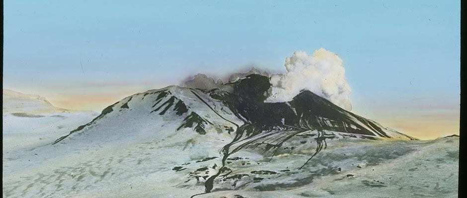
Quaternary Volcanoes . At the Devonian fault, west of Bockfjorden,
two extinct volcanoes, Sverrefjellet and Sigurdfjellet, occur. They
consist, according to Goldschmidt, of an alkali-rich trachydolerite,
made up chiefly of titaniferous augite, plagioclase, olivine, and a
little magnetite. It is probable that the warm springs, Jotunkjeldane
and Trollkjeldane, on the western shore of Bockfjorden, with temperatures
up to 28.3°C., are lingering effects from the volcanic activity. The
springs have deposited basins of calcareous sinter. There are also some
small embryologic volcanoes considered by Hoel to be explosion pipes.
Hoel has localized lapilli and volcanic ash in the terrace material at
47 and 24.5 meters above sea level, and he is of opinion that these
terraces were deposited during the eruption that took place after the
last glaciations.Anders K. Orvin
030 | Vol_I-0470
EA-I. Orvin: Geology
BIBLIOGRAPHY
1. Orvin, A.K. Bibliography of Literature about the Geology, Physical Geog–
raphy. Useful Minerals, and Mining of Svalbard . Oslo, 1947.
Norsk Polarinstitutt. Skrifter Nr.89. (In this paper all literature con–
cerning the geology of Svalbard until 1944 is included. As the geo–
logical literature about Svalbard is very extensive, we must refer to
the above paper. In the following list only some of the more important
papers have been included.)2. Blomstrand, C.W. Geognostiska Iakttagelser under en Resa till Spetsbergen
a o r 1861 . Stockholm, 1864. Svenska Vetenskapsakad., Handl . B.4., no.6.3. Blüthgen, Joachim. Die Fauna and Stratigraphie des Oberjura und der Unter–
kreide von König Karl Land . Gerimmen in Pommern, 1936.4. De Geer, Gerard. “Om östra Spetsbergens glaciations under istiden,”
Geologiska Föreningen, Stockh., Förh . B.22. H.5, pp.427-36, 1900.5. ----. “Some leading lines of dislocation in Spitsbergen,” Ibid . B.31, H.4,
pp.199-208. 1909.6. Frebold, Hans. Fazielle Verhältnisse des Mesozoikums im Eisfjordgebiet
Spitzbergens. I.Teil. Oslo, 1931. Norsk Polarinstitutt. Skr fl lf ter Nr.37.7. ----. Das Festungsorofil auf Spitzbergen. IV. Die Brachinoden- und
Lemellibranchiatenfaune und die Stratigraphie des Oberkerbons und
Unterperms . Oslo, 1937. Ibid . Nr.69.8. ----. Das Festungsprofil aur Spitzbergen. V. Stratigraphie und Inverte –
bratenfauna der älteren Eotrias . Oslo, 1939. Ibid . Nr.77.9. ----. Das Festungsprofil auf Spitzbergen. Jura und Kreide. II. Die
Stratigraphie . Oslo, 1928. Ibid . Nr. 19.10. ----. Geologie von Spitzbergen, der Bäreninsel, des König Kerl- und Franz–
Joseph-Landes. Berlin, Borntraeger, 1935. Geologie der Erde .11. ----. Oberer Lias und unteres Callovien in Spitzbergen . Oslo, 1929.
Norsk Polarinstitutt. Sicr fi if ter Nr. 20.12. ----. Untersuchungen über die Fauna, die Stratigraphie und Paläographie
der Trias Spitzbergens . Oslo, 1929. Ibid . Nr.26.13. ----. Verbreitung und Ausbildung des Mesozoikums in Spitzbergen , Oslo,
1930. Ibid . Nr.31.
031 | Vol_I-0471
EA-I. Orvin: Geology
14. ----, and Stoll, E. Das Festungeprofil auf Spitzbergen. III. Stratigraphie
und Fauna des Jura und der Unterkreide . Oslo, 1937. Ibid . Nr. 68.15. Føyn, Sven, and Heintz, Anatol. The Dwontonian and Devonian Vertebrates of
Spitsbergen. VIII. The English-Norwegian-Swedish Expedition 1939 .
Geological Results. Oslo, 1943. Ibid . Nr. 85.16. Goldschmidt, V.M. Petrographische Untersuchungen einiger Eruptivgesteine von
Nordwestspitzbergen . Kristiania, 1911. Norske Videnskaps-Akad.,
Mat h .-Nat.Kl., Skrifter Nr.9.17. Gothan, W. Die Fossilen Hozreste von Spitzbergen . Stockholm, 1910.
Svenska Vetenskapsakad., Handl . B.45, no.8.18. Gripp, Karl. Beiträge zur Geologie von Spitzbergen . Hamburg Univ. Abhandl .
Nat . B.21, 1927.19. Hagerman, T. H. “Results of the Swedish expedition to Spitzbergen in 1924.
II. Stratigraphic and structural investigations within southwestern
Spitzbergen,” Geografiska Ann ., Stockh, Arg.7, H.3, pp.195-221, 1925.20. Heer, Oswald. Beiträge zur fossilen Flora Spitzbergens . Stockholm, 1876.
Svenska Vetsnskapsakad., H ne en dl . B.14, no.5.21. ----. Fossile Flora der Bären-Insel. Enthaltend die Beschreibung von den
Horrn A.E. Nordenskiöld und A.J. Mamgren im Sommer 1868 der dort
gefundenen Pflanzen . Stockholm, 1871. Ibid . B.9, no.5.22. ---. Die Miocene Flora und Fauna Spitzbergens. Mit einem Anhang über die
Diluvialen Ablagerungen Spitzbergens . Stockholm, 1870. Ibid . B.8, no.7.23. Heintz, Anatol. Die Downtonischen und Devonischen Vertebratan von Spitz–
bergen. VI. Lu n aspis-Arten aus dem. Devon. Spitgbergens . Oslo. 1937.
Norsk Polarinstitutt. Skrifter Nr. 72.24. Hoel, Adolf. Exploration du Nord-Ouest du Spitsberg Enterprise sous les
Auspices de S.A.S. le Prince de Monaco par la Mission. Ieachsen. Troi–
si eème Partie. Geéologie. Monaco, 1914. Albert I. Prince of Monaco.
R e é sultats .25. ----. Nouvelles Observations sur le Distruct Volcanique du Spitsberg du
Nord. Kristiana, 1914. Norske Videnskaps-Akad., Math.-Nat.Kl.,
Skrifter Nr.9.26. ----, and Holtedahl, O. Les Nappes de Laves, les Volcans et les Sources
Thermales dans les Environs de la Bai Wood au Spitsberg . Kristiania,
1911. Ibid . Nr.8.27. ----, and Orvin, A.K. Das Festungsprofil auf Spitzbergen. Karbon-Kreide.
I. Vermessungsresultata . Oslo, 1937. Norsk Pllarinstitutt. Skr fi if ter
Nr.18.
032 | Vol_I-0472
EA-I. Orvin: Geology
28. Holtedah, Olaf. Zur Kenntnis der Karbonablagerungen des Westlichen
Spitgbergens. I. Eine Fauna der Moskauer Stufe . Kristiania, 1911.
Norske Videnskaps-Akad., Math.-Nat.Kl., [ ?] Skrifter Nr.10.29. ----. Zur Kenntunis der Karbonablagerungen des Westlichen Spitzbergens.
II. Algemeine Stratigraphische und Tektonische Beobachungen . Kris–
tiania, 1913. Ibid . Nr.23.30. Horn, Gunnar, and Orvin, A.K. Geology of Bear Ialand . Oslo, 1928.
Norsk Polarinstitutt, [ ?] Skrifter Nr.15.31. Høeg, O.A. The Downtonian and Devonian Flora of Spitsbergen . Oslo, 1942.
Ibid . Nr.83.32. Kulling, Oskar. “Scientific results of the Swedish-Norwegian Arctic
Expedition in the summer of 1931. Part 11. The ‘Helka Hoek Formation’
round Hinlopenstredet,” Geografiska Ann ., Stockh. Arg.16, H.4,
pp.161-254. 1934.33. Lutkevich, E.M. Geologiia tretichnykh uglenosnykh otlozhenii Shpitsbergena
raiona aisfiords.” (Geology of the tertiary, coal-bearing deposits
of Spitsbergen in the ice-fjord-region.) Leningrad. Articheskii
Nauchyi-Issled. Inst., Trudy vol.76, pp.7-24, 1937. (In Russian with
English summary.)34. Nathorst, A.G. “Beiträge zur Geologie der Bären-Insel, Spitzbergens und
des König-Karl-Landes,” Uppsala Univ ., Min.-Geol.Inst., Bull . vol.10,
pp.261-416, 1910/11.35. Nordenskiöld, A.E., Geografisk och Geognostisk Beskrifning öfver Nordöstra
Delarne af Spetsbergen och Hinlopen Strait . Stockholm, 1863.
Svenska Vetenskapsakad., Handl . B.4, Nr.7, 1863.36. ----. “Utkast till Isfjordens och Belsounds geologi,” Geologiska Föreningen,
Stockh., Förh . B.2, pp.243-60, 301-22, 356-73, 1874/75.37. ----. Utkast till Spetsbergens Geologi . Stockholm, 1866. Svenska
Vetenskapsakad., Handl . B.6, Nr.7.38. Obruchev, Sergei. “Geologische Skizze der Ostküste von Spitzbergen zwischen
den Busen Whales Bay und Agardh Bay,” Morskoi Nauchnyi Inst., Moscow,
Trudy vol.2, no.3, pp.59-88, 1927.39. Odell, N.E. “Preliminary notes on the geology of the eastern parts of central
Spitsbergen,” Geol.Soc.Lond., Quart.J . vo.83, pt.1, pp.147-62, 1927.40. Orvin, A.K. Geology of the Kings Bay Region, Spitsbergen . Oslo, 1934.
Norsk Polarinstitutt, Skrifter Nr.57.41. ----. Outline of the Geological History of Spitsbergen . Oslo, 1940.
Ibid . Nr.78.
033 | Vol_I-0473
EA-I. Orvin: Geology
42. Ravn, J.P.J. On the Mollusca of the Tertiary of Spitsbergen. Kristiania,
1922. Ibid. B.1, Nr.2, 1922.43. Sandford, K.S. “The geology of North-East Land (Spitsbergen),” Geol.Soc.
Lond., Quart.J. vol.82, pt.4, pp.615-65, 1926.44. Schenck, Erwin. “Kristallin und Devon im nördlichen Spitzbergen,”
2 Geologische Rundschau B.28, H.1-4, pp.112-24, 1937.45. Schetelig, Jacob. Les Formations Primitves. Exploration du Nord-Ouest
du Spitsberg Entreprise sous les Auspices de S.A.S. le Prince de
Monaco par la Mission Isachsen . Monaco, 1912. Albert I. Prince of
Monaco. R e é sultats Fasc.43.46. Skolov, D., and Bodylevsky, W. Jura- und Krsideformen von Spitsbergen .
Oslo, 1931. Norsk Polarinstitutt. Skrifter Nr.35.47. Steneiö, Erik A:son. Downtonian and Devonian Vertebrates of Spitsbergen.
Part I. Family Cephalaspidae . A.Text. B.Plates. Oslo, 1927.
Ibid . Nr.12, 1922.48. ----. Triassic Fishes from Spitsbergen. Part I . Wien, 1921.
49. ----. ----. Part II . Stockholm, 1925. Svenska Vetenskapsakad., Handl .
ser.3, B.2, no.1.50. ----. “Zur Kenntnis des Devons und des Kulms und der Laaas Klass Billenbay,
Spitzbergen,” Uppsala Univ ., Min.-Geol.Inst., Bull . vol.16, pp.65-80, 1918.51. Tyrrell, G.W. “The geology of Prince Charles Foreland, Spitsbergen,” Roy.
Soc.Edinb., Proc . Vol.53, pt.2, no.23, pp.443-78, 1924.52. ----. “Pre-Devonian basement complex of central Spitsbergen,” Ibid . vol.53,
pt.1, no.10, pp.209-29, 1922.53. ----. “Stratigraphical observations in the Stor Fjord region of Spits–
bergen,” Roy.Soc.Edinb., Trans . Vol.57, pt.3, no.27, pp.675-90, 1933.54. ----, and Sandford, K.S. “Geology and petrology of the Dolerites of Spits–
bergen,” Roy.Soc.Edinb., Proc . Vol.53, pt.3, no.21 pp.284-321, 1933.55. Vogt,Th. “ B retrykk-teori og jordskorpe-bevegelser i artiske trakter i ny
tid.” Norsk Geografiak Tidsskr . B.1, pp.335-86, 1927.Anders K. Orvin