-
Volcanoes of Alaska
Encyclopedia Arctica Volume 1: Geology and Allied Subjects
Unpaginated | Vol_I-0321
EA-I. (Robert R. Coats)
VOLCANOES OF ALASKA
CONTENTS
Page Ages of Volcanism 1 Types of Volcanic Activity 2 Relationship of Volcanism to Structure 4 Volcanic Areas 4 The Aleutian Arc 4 Nature of Volcanic Activity 9 Petrographic and Chemical Character of Volcanic Rocks 12 Relation of Volcanism to Structure 12 The Wrangell Mountains 15 Geographic Distribution 15 Nature of Volcanic Activity 16 Petrographic Character of Volcanic Rocks 17 Bering Sea-Seward Peninsula 17 Geographic Distribution 17 Types of Volcanic Activity 17 Petrographic Character of Rocks 18 Southeastern Alaska 18 Geographic Distribution 18 Types of Volcanic Activity 18 Petrographic Character of Rocks 18 Yukon-Tanana Region 19 Bibliography 20
Unpaginated | Vol_I-0322
EA-I. Coats: Volcanoes of Alaska
LIST OF FIGURES
Page Fig. 1 Volcanoes of the Aleutian arc 1-a
Unpaginated | Vol_I-0323
EA-I. Coats: Volcanoes of Alaska
PHOTOGRAPHIC ILLUSTRATIONS
With the manuscript of this article, the author submitted 4
photographs for possible use as illustrations. Because of the high
cost of reproducing them as halftones in the printed volume, only a small
proportion of the photographs submitted by contributors to Volume I,
Encyclopedia Arctica , can be used, at most one or two with each paper;
in some cases none. The number and selection must be determined later
by the publisher and editors of Encyclopedia Arctica . Meantime all
photographs are being held at The Stefansson Library.
001 | Vol_I-0324
E.A-I. [Robert R. Coats]
VOLCANOES OF ALASKA
AGE OF VOLCANISM
Alaska has been the scene of volcani s c activity on a grand scale many —
times in the geologic past. In its broadest sense, volcanism is considered
by some geologists to include not only the eruption of solid, liquid, and
gaseous matter at the surface of the earth, but also the emplacement of
masses of igneous rock at great depths, and even the formation of ore deposits
as a result of those intrusions. The volcanic activity to be considered in
this article, however, will be that which has taken place in the latest
episodes of the earth’s history, comprised within the Quaternary period,
which embraces the Pleistocene (or glacial) epoch and Recent epoch.In Alaska, it is seldom possible to separate the products of these two
epochs, or to draw a line between them, because the Recent is also a time of
extensive glaciations, and large areas in the mountainous parts of Alaska are
still occupied by glaciers, many of which are surviving remnants of the
vastly larger glaciers of the Pleistocene. This is particularly true of the
larger volcanic mountains, and thus we find volcanoes in all stages of glacial
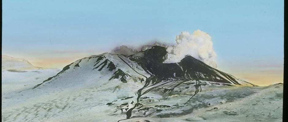
attack, from those still active, like Shishaldin (Fig.1) and Pavlof, which are
sheathed in their [ ?] upper parts by a thin but nearly continuous mantle of ice,
to those like Mount Iliamna (Fig.2), on whose flanks the work of ice and frost
has carved gigantic cirques, with walls many thousands of feet in height.
002 | Vol_I-0325
EA-I. Coats: Volcanoes
Although the epoch of decline of volcani s c activity thus ranges, at many —
of the older centers now recognizable, from the Pleistocene to the Recent, the
time of beginning of the activity is much less easily ascertainable. In the
Wrangell Mountains, and in the vicinity of Mount Spurr, west of Anchorage, there
is evidence that volcanic activity began as far back as the beginning of the
Tertiary period, but it is by no means certain that the same centers have been
active throughout the long interval since that time.Types of Volcanic Activity . The commonest type of volcanic activity, the
products of which bulk the largest, is the persistent eruption from a long–
lived central focus of lava and fragmental material, or pyroclastics. It is
this central type which is responsible for the beautifully symmetrical cone,
rising to a summit crater of relatively small dimensions. Fujiyama, in Japan,
is perhaps the best-known example of this type, but many Alaskan volcanoes,
such as Shishaldin and Mount Cleveland (Fig.3), are scarcely inferior to it
in perfection of form.The most spectacular central volcanic eruptions, such as that of Katmai,
in 1912, have sometimes resulted in the collapse of the summit regions of the
volcanoes, leaving in their stead great circular or elliptical depressions
called calderas. Many of these, where favorably situated, have been filled with
ice, through which the feebly reviving volcanic activity has in some places
erupted cones of black cinders (Fig.4) or protruded massive eruptions of lava,
now encumbered by carapaces of great blocks, piled in the wildest confusion.
003 | Vol_I-0326
EA-I. Coats: Volcanoes
Elsewhere, the volcanic activity has been shorter-lived and less strictly
confined to a few centers and has, therefore, resulted not in symmetrical
mountains or in profound calderas, but in inconsiderable hills or minor cones
of cinders and scoriae, rising but a few hundred or a thousand feet above
their bases. Some of these are surrounded by extensive plains composed of
several flows of funereal basalts, their surfaces still betraying the recency
of their formation by festoons or arcuate ridges of cinders and blocks, with
intervening moatlike depressions — the wrinkles on the surface of the flowing
lava. At other places the chance guidance of topography has confined the
superfluent lava to a few narrow channels, where the reduced rate of dissi–
pation of heat may permit it to reach much greater distances from the source.All of these expressions of volcanism with which we shall deal have, as
a common consequence of their youth, an influence upon the landscape dispro–
portionate to their total bulk, and one which is far more expressive of their
volcanic origin than of the effects of the subaerial agents of denudation.
For this and other reasons, this article will be confined to these latest
manifestations of volcanic activity.The Quaternary volcanic activity in Alaska thus falls naturally into two
major types: ( 1 ) central eruptions, leading to the erection of isolated vol–
canic mountains or groups of mountains or to the formation of calderas; and ( 2 )
cinder cone and plateau eruptions, resulting in thin, though perhaps widespread,
basaltic flows and generally minor and inconspicuous hills. The locations of the
principle volcanic mountains are fairly well known, and they can be delineated
upon a map. The areas of the other type of eruption are not as well known, and
in many places the information required to separate them from accompanying flows
of greater age is not available. Therefore, the places where these lavas occur
will be described in general, but no attempt will be made to delineate them on a map.
004 | Vol_I-0327
EA-I. Coats: Volcanoes
Relationship of Volcanism to Structure . The two types of volcanisc acti–
vity distinguished above are also associated with two different types of
structure. The linear chains or groups of central volcanoes are closely re–
lated geographically to the axes of Quaternary and recent mountain-building
movements in Alaska. The close association of the Aleutian volcanic chain
with the profound foredeep of the Aleutian Trench has been remarked upon by
many. Compressional deformation with open folding and th ur ru sting is character–
istic. The basalts that form the minor centers characterize areas of much
greater recent stability, where the Quaternary and recent movements are largely
epirogenic, characterized by broad warpings and minor faults, generally
tensional.VOLCANIC AREAS
The Quaternary volcanism of Alaska can be considered, for convenience, as
confined to five principal regions. These are, in order of diminishing impor–
tance: the Aleutian arc, including the Aleutian Islands and Alaska Pen i nsula;
the Wrangell Mountains; the Bering Sea-Seward Peninsula region; southeastern
Alaksa; and the Yukon-Tanana region.The Aleutian Arc
About 74 mountains known to be volcanoes are spread in a broad arc extending
about 1,700 miles from Buldir Island eastward through the Aleutian Islands,
along the Alaska Peninsula and the mainland of Alaska, to Mount Spurr. These
are listed with their heights and positions in Table I.
005 | Vol_I-0328
EA-I. Coats: Volcanoes
The 74 volcanoes listed include only those that form independent structures
of considerable size, and which are known to have been active in historic time,
or which show features indicating that they have probably been active in
Quarternary or recent time. Thirty-six volcanoes are known to have been active
in historic time (since 1760); their names are indicated by asterisks in this
table.Table I. Volcanoes of the Aleutian Arc . —
(Arranged in geographic order, from west to east)Name Geographic
SubdivisionLatitude Longitude Altitude,
metersBuldir Buldir I. 52°32′N. 176°01′E. 620 Kiska* Kiska I. 52°06′N. 177°36′E. 1,220 Segula Segula I. 52°01′N. 178°08′E. 1,159 Little Sitkin * Little Sitkin I. 51°57′N. 178°32′E. 1,195 — Cerberus* Semisopochnoi I. 51°56′N. 179°35′E. 775 Sugarloaf Semisopochnoi I. 51°54′N. 179°38′E. 857 Gareloi* Gareloi I. 51°48′N. 178°48′W. 1,627 Tanaga* Tanaga I. 51°53′N. 178°07′W. 2,125 Takawangha Tanaga I. 51°52′N. 178°00′W. 1,540 Bobrof Bobrof I. 51°55′N. 177°27′W. 793 Kanaga* Kanaga I. 51°55′N. 177°10′W. 1,348 Moffet Adak I. 51°56′N. 176°45′W. 1,180 Adagdak Adak I. 51°59′N. 176°36′W. 631 Great Sitkin* Great Sitkin I. 52°04′N. 176°07′W. 1,750 Kasat o chi Kasatochi I. 52°11′N. 17 6
5 °30′W.310 —
006 | Vol_I-0329
EA-I. Coats: Volcanoes
Table I. Volcanoes of the Aleutian Arc (Continued) . — Name Geographic
SubdivisionLatitude Longitude Altitude,
metersKoniuji* Koniuji I. 52°13′N. 175°08′W. 268 Sergief Atka I. 52°19′N. 174°23′W. 560 ± plus or minus — Korovin* Atka I. 52°23′N. 174°10′W. 1,480 Kliuchef Atka I. 52°19′N. 174°09′W. 915 + Sarichef* Atka I. 52°19′N. 174°03′W. 610 + Seguam* Seguam I. 52°19′N. 172°23′W. 1,052 Amukta * Amukta I. 52°30′N. 171°16′W. 1,058 — Chagulak Chagulak I. 52°35′N. 171°09′W. 1,142 Yunaska* Yunaska I. 52°39′N. 170°39′W. 600 Herbert Herbert I. 52°45′N. 170°07′W. 1,290 Carlisle* Carlisle I. 52°54′N. 170°04′W. 1,610 Cleveland* Chuginadak I 52°49′N. 169°58′W. 730 Uliaga Uliaga I. 53°04′N. 169°47′W. 887 Tana Chuginadak I. 52°50′N. 169°46′W. 1,170 Kagamil* Kagamil I. 52°58′N. 169°44′W. 892 Vsevidof* Umnak I. 53°08′N. 168°42′W. 2,110 Recheschnoi Umnak I. 53°09′N. 168°33′W. 1,940 Okmok* Umnak I. 53°25′N. 168°03′W. 1,072 Tulik Umnak I. 53°23′N. 168°03′W. 1,252 Bogoslof* Bogoslof I. 53°56′N. 168 _ °02′W. 50 + Makushin* Unalaska I. 53°52′N. 166°56′W. 2,036 Akutan* Akutan I. 54°08′N. 166°00′W. 1,293
007 | Vol_I-0330
EA-I. Coats: Volcanoes
Table I. Volcanoes of the Aleutian Arc (Continued) . — Name Geographic
SubdivisionLatitude Longitude Altitude,
metersAkun Akun I. 54°16′N. 165°39′W. 819 Pogromni* Unimak I. 54°34′N. 164°42′W. 1,987 Fisher* Unimak I. 54°38′N. 164°25′W. 1,074 Shishaldin* Unimak I. 54°45′N. 163°58′W. 2,858 Isanotski* Unimak I. 54°45′N. 163°44′W. 2,480 Roundtop Unimak I. 54°48′N. 163°36′W. 1,872 Amak Amak I. 55°25′N. 163°09′W. 513 Frosty Alaska Pen. 55°04′N. 162°51′W. 1,777 Emmons Alaska Pen. 55°20′N. 162°04′W. 1,326 [?] — Hague Alaska Pen. 55°22′N. 161°59′W. 1,400 + “Double” Crater Alaska Pen. 55°23′N. 161°57′W. 1,400 + Pavlof* Alaska Pen. 55°25′N. 161°54′W. 2,715 Palvof Sister* Alaska Pen. 55°27′N. 161°51′W. 2,135 + Dana Alaska Pen. 55°37′N. 161°12′W. 1,280 + Kupreanof Alaska Pen. 56°01′N. 159°48′W. 1,525 + Veniaminof* Alaska Pen. 56°10′N. 159°48′W. 2,560 + Purple Alaska Pen. 56°32′N. 158°37′W. 955 + Aniakchak* Alaska Pen. 56°53′ , N. 158°10′W. 1,348 Chiginagak* Alaska Pen. 57°08′N. 157°00′W. 2,420 Peulik* Alaska Pen. 57°45′N. 156°21′W. 1,525 Martin Alaska Pen. 58°09′N. 155°24′W. 1,830 +
008 | Vol_I-0331
EA-I. Caots: Volcanoes
Table I. Volcanoes of the Aleutian Arc (Continued) Concluded. — Name Geographic
SubdivisionLatitude Longitude Altitude,
metersMageik* Alaska Pen. 58°12′N. . 155°15′W. 2,210 Knife Peak Alaska Pen. 58°20′N. 155°08′W. 2,313 Trident Alaska Pen. 58°14′N. 155°07′W . 2,070 Katmai* Alaska Pen. 58°16′N. 154°59′W. 2,285 Denison Alaska Pen. 58°25′N. 154°27′W. 2,326 Steller Alaska Pen. 58°26′N. 154°24′W. 2,272 Kukak Alaska Pen. 58°27′N. 154°21′W. 2,046 Unnamed Alaska Pen. 58°37′N. 154°05′W. 915 + Fourpeaked Alaska Pen. 58°47′N. 153°42′W. 2,105 Douglas Alaska Pen. 58° 4 5 2′N. 153°33′W. 2,328 — Augustine* Augustine I. 59°22′N. 153°25′W. 1,210 Iliamna* Aleutian Range 60°02′N. 153°06′W. 3,073 Redoubt* Aleutian Range 60°28′N. 152°45′W. 3,110 Double Aleutian Range 60°44′N. 152°35′W. 2,160 Black Aleutian Range 60°51′N. 152°25′W. 1,983 Spurr Aleutian Range 61°18′N. 152°15′W. 3,375
009 | Vol_I-0332
EA-I. Coats: Volcanoes
The geodetic positions of the summits of the volcanoes have been scaled
from the Aleutian Islands Flight Charts Nos. 1, 2, and 3, of the U.S. Army
Air Forces, 1944 editions. In a few instances, more accurate data were obtained
from other maps, principally detailed topographic maps prepared by the Army
Engineers. The flight charts are also the sources for most of the heights
given in the table. Where summit elevations are not precisely known, the
plus sign is used to indicate the approximation.Nature of Volcanic Activity . Although the study of the volcanoes of the
Aleutian arc is far from completed (many of them having not yet been examined
even in a reconnaissance way), certain generalizations, based on the work done
to date, may be offered with considerable confidence that they will not be in–
validated by further work.The older volcanoes of the arc seem to include both shield volcanoes,
characterized by many relatively thin flows accumulated on slopes of low de–
clivity, with a small proportion of fragmental material, and strato-volcanoes
(or composite cones) made up of both flows and fragmental material, the slopes
of which approach the angle of repose of the fragmental material. The major
active volcanoes of the arc are, without exception, composite cones.A striking feature of the arc is the presence on it of large numbers of
calderas, many of great size. For the purpose of this article, the definition
of Williams (23, p. 242) will be adopted: “Calderas are large volcanic de–
pressions, more or less circular … in form …” The lower limit to the
diameter suggested by Williams is one mile. Table II includes.
010 | Vol_I-0333
EA-I. Coats: Volcanoes
Table II includes all calderas known to the writer in May 1949. Others
will be discovered, especially where erosion has altered the characteristic
topographic form sufficiently to disguise their origin. Many of those listed
have been seen only from the air or in aerial photographs, but the characteris–
tic form and relation to the structure exposed in the rimming cliffs are seldom
ambiguous. Where no source is given, the observations of the writer are the
source. Recognition of the caldera is credited to the first-known observer
who recognized it as such.Table II. Calderas of the Aleutian Arc. Name Size, miles Source Name Size, miles Source Devidof 1.5 Makushin 1.5 × 2 (14) Little Sitkin 2.8 Akutan 1.25 (7) Semisopochnoi 3.8 × 4.7 Fisher 6.2 × 6.8 Tanaga 7 ± Morzhovoi (Frosty) 3.5 Takawangha 2 Veniaminof 5.2 (12) Kenaton (Kanaga I.) 2.5 (5) Purple 1.7 × 1.6 (12) Kliuchef 2.8 ± Aniakchak 6 × 5.2 (21) Yunaska 1.8 × 1.5 (22) Katmai 1.3 × 1.2 (9) Okmok 7.5 (6)
It should be noted that the dimensions given in Table II are minima, being
scaled to the base of the lowest accessible part of the bounding cliff; this
accounts for the fact that many of the dimensions given are smaller than those
in the original reports. Where two figures are given, the caldera is notably
elliptical.
011 | Vol_I-0334
EA-I. Coats: Volcanoes
The term “volcanic dome” is used in the sense of Williams (24, p. 54) to
mean a steep-sided viscous protrusion of lava forming a more or less dome–
shaped mass around its vent. Such protrusions are common, as Powers (18)
has shown, in the vicinity of many volcanoes of the circumpacific zone;
commonly they form the final [ ?] phase of activity of the expiring cone. Many
form on the flanks of the volcano. The volcanic domes of Novarupta, near Katmai,
and of Bogoslof are well known; others have been described from Adak Island
(4, ppl 81-82) and from Great Sitkin Island. (19, p. 63). F. M. Byers (personal —
communication, 1948) has recognized an obsidian dome on Umnak, and J. C. Reed
(personal communication, 1948) a dome in the crater of Mount Augustine. Others
are known to be present on Buldir Island, Bobrof Island, L Kliuchef Volcano, —
and at the summit of Roundtop on Unimak. Many “plugs” mapped by Knappen on the
flanks of Veniaminof and Aniakchak are probably domes. On the whole, however,
they are rare in the Aleutian arc compared with the southern part of the
Cascade Range in Oregon and California.Byers (unpublished manuscript) has recently discussed the hot springs
and fumaroles of the Aleutian Islands and prepared the following classification [?] listed in Table III.
listed in Table III.Table III. Fumaroles and Hot Springs of
the Aleutian Arc.double space Type Temperature
range, °C.Acid fumaroles 200-800 Sulfur dioxide solfataras 100-200 Hydrogen sulfide solfataras and springs 5-100 Mofettes and derived springs 5-100 Boroniferous springs and soffioni 5-102
012 | Vol_I-0335
EA-I. Coats: Volcanoes
Most of our information concerning the acid fumaroles is due to Allen
and Zies (1) who worked in the Katmai National Monument. These fumaroles are
characterized by halogen acid gases. The changes that take place with falling
temperature are in part brought about by reaction of the bases with atmospheric
oxygen, with each other, and with the wall rocks. The boroniferous emanations
are generally found in older terranes and are believed by Byers to be derived
from cooling granitic intrusives. The boroniferous springs are characterized
by high content of boron, sodium chloride, and total solids, ranging from
1,000 to 2,500 parts per million.Petrographic and Chemical Character of Volcanic Rocks. The volcanic rocks
of the Aleutian arc range from olivine basalt to rhyolite. They include basalts
characterized by olivine, with hornblende, hypersthene, or both. Relatively
high percentages of conspicuous crystals of calcic plagioclase and usually less
conspicuous green augite characterize most of the rocks. The more silica-rich
rocks, such as dacites and rhyolites, are less plentiful; most are present
either as small bodies of highly - glassy lava or as blankets of light-colored —
pumice.Relation of Volcanism to Structure . The most conspicuous positive element
in the structure of the Aleutian arc is the great curvilinear ridge, extending
southward and westward to Attu from the Alaska mainland, where it merges at its
northeastern end with the Alaska Range. The ridge is notably wider at the
eastern end than at the western end. From it, one branch, about 300 miles long,
extends northward and westward from Semisopochnoi Island, forming a submarine
mountain ridge rising in places 12,000 feet above the sea floor.
013 | Vol_I-0336
EA-I. Coats: Volcanoes
The main ridge is bounded on the north by the lowlands of the Alaska
Peninsula and by the Bering Sea. The eastern part of the Bering Sea, as far
west as a line extending northwestward from Unimak Pass, is very shallow. The
western part of the Bering Sea is deep, and large areas of the bottom form
extensive plains at depths close to 2,000 fathoms (3,700 meters). On the south,
the ridge of the Aleutian Islands is bordered by the Aleutian Trench, a typical
marginal deep, extending to depths of about 4,200 fathoms (7,700 meters). (17).The distribution of earthquake foci (10, p.25; 11, pp. 654-55) is such that
the epicenters of shallow earthquakes tend to be south of the chain; those of
intermediate depth (more than 60 km.) earthquakes are in the islands or north
of the chain. It seems probable that the general structural picture of the
Aleutian Islands will, when more information is available, resemble that pre–
sented by Gutenberg and Richter for the structurally similar Japanese arc. (10,
p. 110). The distribution of deep and intermediate earthquake foci will probably
fall along an active zone or surface, which will be shown to reach the surface
of the crust along the northern slope of the Aleutian Trench, and to dip north–
ward at a moderate angle.The older rocks of the Aleutian arc, dating in some places back to the
Paleozoic, are involved in both folding and faulting. The folding is, in general,
relatively open, and dips are moderate. Major faults are reverse faults, trend–
ing nearly parallel to the trend of the arc; the north side has generally moved
south and up with respect to the south side. In the Aniakchak area , (12, p. 207),
the northwestern overthrust block has generally moved northeast and up with re–
spect to the southeastern block. Tensional faults, trending at an angle to the
trend of the arc, have also been noted.
014 | Vol_I-0337
EA-I. Coats: Volcanoes
In general, the volcanoes are superficial structures, built upon a base–
ment of Tertiary and older rocks that is exposed at intervals throughout the
length of the arc. The nature of the structures which have determined the
positions of the eruptive centers can be determined in few places. Some have
thought that the belt of volcanoes, because of its narrowness, coincides with
the surface trace of a great thrust plane or fault, movement on which is thought
to be responsible for the frequent earthquakes. In detail, the volcanic belt
does not form a simple arc, but consists of segments of differing length; the
included angles between adjacent segments may be as little as 140°. In the
Aniakchak region, Knappen has mapped a tension fault with an east-west trend,
along or close to which several volcanic structures are alined; he considered
that the site of the eruptive center has been determined by the existence of
the fault. It is probable that similar relationships exist elsewhere in the arc,
and that most of the volcanoes have had [ ?] their sites determined by minor ten–
sional fractures striking at an angle to the major thrust zones. The distance
of the volcano from the major active zone of movement is probably dependent
upon the depth at which such a tensional fracture, originating in and limited
to an overthrust block, taps eruptable magma. The minor tensional faults, by
this hypothesis, bear a spatial relationship to the hypothetical major active
zone similar to that of the “feather fractures” of Cloos . (3, pp. 387-95).
015 | Vol_I-0338
EA-I. Coats: Volcanoes
Wrangell Mountains
Geographic Distribution . The Wrangell Mountains form an isolated group of
high peaks about 150 miles north of the northernmost part of the Gulf of Alaska.
They form the drainage divide between the waters of the Tanana, the Copper, and
the Yukon rivers.Table IV. Volcanic Centers in the Wrangell Mountains. Name Latitude Longitude Altitude, meters Sanford 62°13′N. 144°08′W. 4,938 Wrangell 62°01′N. 144°04′W. 4,285 Drum 62°07′N. 144°39′W. 3,658 Jarvis 62°02′N. 143°36′W. 3,749 Blackburn 61°44′N. 143°24′W. 4,919 Regal 61°44′N. 142°52′W. 4,084
The principal volcanic centers in the Wrangell Mountains are listed in
Table IV. Mount Wrangell (Chehitno, Chitina) is the sole active volcano in
this group. It is reported (8) , somewhat doubtfully, to have been in eruption
in 1760 and 1784, as well as in 1884; according to F. H. Moffit (personal com–
munication), 1899 was marked by considerable explosive [ ?] activity. In recent
years, steam condensation clouds have been observed about the summit on many
occasions; photographs taken in June 1948 showed a thin deposit of cinders on
the snow near the present vent. All recorded activity has been mildly explosive.It is probable that volcanism in this area commenced in the Eocene; it is
not certain that so great an age can be ascribed to any center now recognizable
as a volcano.
016 | Vol_I-0339
EA-I. Coats: Volcanoes
Nature of Volcanic Activity . Both explosions and quiet extravasation of
lava have had a part in building up the Wrangell Mountains, as shown by the
character of the material exposed in the slopes, which includes tuffs, flows,
and bombs. The relatively low dips recorded from many areas suggest that some
of these mountains may be shield volcanoes, constructed largely of numerous
flows of rather fluid lava. Doubtless a substantial part of the structures
consists of tuff-breccias, the result of extravasation of lavas beneath the
glaciers, in a manner analogous to the subglacial eruptions of Iceland. The
descriptions in some of the older reports suggest that volcanic domes may also
be present . (15, p. 62).In all probability the most spectacular volcanic eruption of postglacial
time in this area was that responsible for the blanket of light-colored volcanic
ash that covers a total area of more than 140,000 sq.mi. in eastern Alaska and
southwestern Yukon Territory. Capps (2) computed the volume of the deposit
at 10 cu.mi., and thought the most probable source was a small vent, reported
by Thomas Riggs, Jr., in the area just northeast of Mount Natazhat. Mount
Natazhat itself is not a volcano, but is made up of Carboniferous lava flows
and sediments. Examination of aerial photographs of the St. Elias Range, taken
since the war, shows a large, circular ice-filled basin, about 3.7 miles in
diameter, at about 61°24′N. and 142°03′W. The precipitous walls attain an alti–
tude estimated at about 10,000 feet. It seems probable that this caldera is
the source of the recent ash of the upper Yukon and White rivers.
017 | Vol_I-0340
EA-I. Coats: Volcanoes
Petrographic Character of Volcanic Rocks . The Wrangell lavas (15, pp. 54-62)
range from black aphanitic and glassy rocks to holocrystalline, porphyritic,
light-gray varities. Others are brick-red, pink, pale lavender, brown, or
greenish. The common phenocrysts are plagioclase of intermedia r t e to calcic —
composition, brown hornblende, hypersthene, augite, biotite, and olivine.
The commonest rocks are hypersthene or hornblende andesites, but basalts and
dacites are also present. Sufficient information is not available to permit
any conclusions as to petrographic differences between the Wrangell lavas and
those of the Aleutian Islands.Bering Sea-Seward Peninsula
—Geographic Distribution . Within the Bering Sea-Seward Peninsula region,
the principal areas of Quaternary volcanism are the following (20, pp. 84-86) :
the Pribilof Islands; the north-central part of St. Lawrence Island; an area
south and southwest of Imuruk Lake in the central part, and north of the Koyuk
River in the eastern part of the Seward Peninsula; areas in the vicinity of St.
Michael, east of the mouth of the [ ?] Yukon River; Nunivak and Nelson Islands;
and Hagemeister Island and an area in the vicinity of the Togiak River.Types of Volcanic Activity . All of the areas, wherever [ ?] studied, are charac–
terized by flows of lava with ropy, aa, or blocky surfaces, generally, and, because
of their recency, quite undissected. Some have extensive lava tubes, which, to–
gether with the low gradients on which the lavas flowed, indicate their fluidity.
Fragmental material is much less important, but cinder cones mark some sites of
eruption. On St. Lawrence Island in the Kookooligit Mountains, numerous cinder cones,
composite cones, and plugs have been mapped (H. B. Allen, personal communication, 1949).
Some of these have a random distribution, others are aligned on zones trending east
and west. The cones crown a plateau of basalt of slightly greater age, and are sur–
rounded by widespread flows and intercalated pyroclastics, the flows ranging in
thickness from 20 to 100 feet.
018 | Vol_I-0341
EA-I. Coats: Volcanoes
Petrographic Character of Rocks . Little information concerning the charac–
ter of the lavas is available. Those of the Seward Peninsula and St. Lawrence
Island are said to be chiefly olivine basalts; according to T. F. W. Barth (un–
published manuscript), the lavas of the Pribilof Islands belong to the plateau
basalt type.Southeastern Alaska
Geographic Distribution . The principal center of Quaternary volcanic
activity in southeastern Alaska is Mount Edgecumbe, 3,467 ft. (1,057 m.) high,
57°03′N. 135°46′W., just west of Sitka. The other area of Quaternary volcanic
rocks includes patches near Unuk River, and also on the southern part of
Revillagigedo Island and the nearby mainland.Types of Volcanic Activity . The activity of Mount Edgecumbe, which is
doubtfully reported to have continued to 1796, has resulted in the construction
of a composite cone of flows and pyroclastic rocks, about the base of which
the flows have spread rather widely . (13, pp. 14-15). Ash eruptions, presumably
from Mount Edgecumbe, attain depths of 10 feet or more in the vicinity of Sitka;
even in the Chichagof mining district, 45 miles to the northwest, it averages
perhaps 6 inches in thickness.The flows of the Revillagigedo Island area are flat lying, and generally
confined to the present lowlands. The nature of the source vents is not known.Petrographic Character of Rocks . The lavas in the vicinity of Revillagigedo
Island are reported by L.G. Westgate (unpublished manuscript) to be hornblende-bearing —
augite andesites and basalt. The lavas of Mount Edgecumbe are reported by Knopf
(13, p. 14) to be basic andesite and basalt, generally olivine-bearing.
019 | Vol_I-0342
EA-I. Coats: Volcanoes
Yukon-Tanana Region
Quaternary volcanic rocks are unimportant in the Yukon-Tanana region.
A small cinder cone of basalt has been described by Mertie . (16, p. 39) . Its
complete lack of dissection suggests that it is relatively youthful. In a
few other places in the Yukon-Tanana area, minor basalt flows have been found,
which generally occupy the present valleys, and are also somewhat dissected
by the steams in them, suggesting a somewhat greater age.Robert R. Coats
020 | Vol_I-0343
EA-I. Coats: Volcanoes
BIBLIOGRAPHY
1. Allen, E.T, and Zies, E.G. A Chemical Study of Fumaroles of the Katmai
Region . Wash.,D.C., Nat.Geogr.Soc., 1923. The Society. Contributed
Tech.Pap., Katmai Ser . No.2.2. Capps, S.R. “An ancient eruption in the upper Yukon Basin.” U.S.Geol.Surv.,
Prof.Pap . 95. Wash.,D.C., G.P.O., 1916, pp.59-64.3. Cloos, Ernst. “‘Feather joints’ as indicators of the direction of movements
on faults, thrusts, joints and magmatic contacts,” Nat.Acad.Sci.,
Wash., Proc . Vol.18, pp.387-95, 1932.4. ✓ Coats, Roberts. “Geology of northern Adak island, [?] U.S.Geol.Surv. Alaskan
Volcano Investigations. Report No.2. Wash.,D.C., G.P.O., 1947, pt.5,
pp.72-85.5. ----, “Geology of northern Kanaga island,” U.S.Geol.Surv. Alaskan Volcano
Investigations. Report No.2. Wash.,D.C., G.P.O., 1947, pt.6.6. Dunn, Robert. “On the chase for volcanoes,” Outing , vol.51, pp.540-50, 1908.
7. Finch, R.H. “Akutan volcano,” Zeitschrift für Vulkanol . B.16, H.3, pp.155-60,
1935.8. Grewingk, Constantin. “Beitrag zur Kenntniss der orographischen und geognos–
tischen beschaffenheit der nordwest Kueste Amerikas, mit den anliegenden
Inseln,” Vserossiiskoe Min. Obahch., Leningr., Zapiski , 1849/50.9. ✓ Griggs, R.F. “The K [?] a tmai National Monument and Valley of Ten Thousand
Smokes,” Science , n.s., vol.49, pp.236-37, 1921.10. Gutenberg, Beno, and Richter, C.F. Seismicity of the Earth . N.Y., 1941.
Geol.Soc.Amer. Spec.Pap . no.34.11. ----, ----. “Seismicity of the earth,” Geol.Soc.Amer. Bull . Vol.56, pp.603-
58, 1945.12. Knappen, R.S. “Geology and mineral resources of the Aniakchak district,”
U.S.Geol.Surv. Bull . 797. Wash.,D.C., G.P.O., 1929, pp.161-227.13. Knopf, Adolf. The Sitka Mining District, Alaska . Wash.,D.C., G.P.O., 1912.
U.S.Geol.Surv. Bull . 504.14. Maddren, A.G. “Sulphur on Unalaska and Akun Islands and near Stepovak Bay,”
U.S.Geol.Surv. Bull . 692. Wash.,D.C., G.P.O., 1919, pp.283-98.
021 | Vol_I-0344
EA-I. Coats: Volcanoes
15. ✓ Mendenhall, W.C. Geology of the Central Copper River Region, Ala k s .
Wash.,D.C., G.P.O., 1905. U.S.Geol.Surv. Prof.Pap . 41.16. Mertie, Jr., J.B. A Geologic Reconnaissance of the Dennison Fork District,
Alaska . Wash.,D.C., G.P.O., 1931. U.S.Geol.Surv. Bull . 827.17. Murray, H.W. “Profiles of the Aleutian Trench,” Geol.Soc.Amer. Bull . Vol.56,
pp.757-81, 1945.18. Powers, Sidney. “Volcanic domes in the Pacific,” Amer.J.Sci . ser.4, vol.42,
pp.261-74, 1916.19. ✓ Simons, F.S., and Mat h t hewson, D.E. “Geology of Great Sitkin Island,” U.S.
Geol.Surv. Alaskan Volcano Investigations, Report No.2. Wash.,D.C.,
G.P.O., 1947. Pt.4, pp.55-70.20. Smith, P.S. Areal Geology of Alaska . Wash.,D.C., G.P.O., 1939. U.S.Geol.
Surv. Prof.Pap . 192.21. ✓ Smith, W.R. “Aniakchak crater, Alaska Peninsula,” U.S.Geol.Surv. Prof.Pap .
1932. Wash.,D.C., G.P.O., 1925. pp.139-49.22. U.S. Coast and Geodetic Survey. United States Coast Pilot. Alaska. Part II.
Yakutat Bay to Arctic Ocean . 5th (1947) ed. Wash.,D.C., G.P.O., 1947.23. Williams, Howel. “Calderas and their origin,” Calif.Univ. Publ.Geol.Sci .
vol.25, no.6, pp.239-346, 1941.24. ✓ ----. “The history and charac t t er of volcanic domes,” Ibid . vol.21, no.5,
pp.51-146, 1932.Robert R. Coats