-
Physiography of Alaska
Encyclopedia Arctica Volume 1: Geology and Allied Subjects
Unpaginated | Vol_I-0183
EA-I. (Clyde Wahrhaftig)
PHYSIOGRAPHY OF ALASKA
CONTENTS
Page Introduction 1 Coasts 2 Physiographic Regions 4 Arctic Plains and Foothills Region 4 Arctic Coastal Plain 4 Arctic Foothills Province 5 Brooks Range 6 Central Plateau Region 8 Seward Peninsula 10 Mountains between Norton Sound and the Yukon River 11 Lowlands of the Lower Yukon and Koyukuk 12 Delta of the Yukon and Kuskokwim 13 Yukon and Koyukuk Flats 13 Yukon Plateau 15 Kuskokwim and Kilbuck Mountains 18 Tanana-Kuskokwim Flats 20 Pacific Mountain System 22 Alaskan Range 24 Aleutian Range 27 Talkeetna Mountains 28 Wrangell Mountains 30 Susitna-Cook Inlet Lowland 31 Copper River Plateau 33 Chugach-Kenai Mountains 34 St. Elias Range 37 British Columbia Coast Range (Coast Mountains) 37 Topographic Details in Glaciated and Nonglaciated Areas 39 Physiographic History of Alaska 40 Bibliography 42
Unpaginated | Vol_I-0184
EA-I. Wahrhaftig: Physiography of Alaska
MAPS
Page Plate I Physiographic regions and provinces in Alaska 4-a Plate II Physiographic diagram of Alaska 4-b
001 | Vol_I-0185
EA-I. (Clyde Wahrhaftig)
Author: Where do
references (17) and (24)
go? (new numbers).PHYSIOGRAPHY OF ALASKA
INTRODUCTION
The larger part of the Territory of Alaska is an irregular rectangular
peninsula forming the extreme northwest corner of the North American con–
tinent, approximately between meridians 141° and 168° W. longitude and
parallels 58° and 72° N. latitude (see plate 1.). The natural boundaries
of this peninsula are the Arctic Sea on the north, the Chukotak and Bering
seas on the west, and the Pacific Ocean on the south. The artificial boundary
on the east, along meridian 141° W. longitude for nearly the entire distance
between the Arctic Sea and the Pacific Ocean, is the political boundary between
Alaska and the Yukon Territory of Canada. On the west, the extremity of the
Seward Peninsula is only 56 miles form the Siberian mainland; and the two
Diome t d e Islands, which are situated between the Seward Peninsula and the ✓
Siberian coast of Bering Strait, lie on opposite sides of the international
boundary.The projection to the southwest and west along the Alaska Peninsula, 500
miles in length, and the Aleutian Islands are, 1,100 miles in length, extends
the Territory of Alaska nearly to meridian 172° E. longitude.In the opposite direction to the southeast, the panhandle of southeastern
Alaska includes a narrow strip along the Pacific coast mainland and the adjacent
002 | Vol_I-0186
EA-I. Wahrhaftig: Physiography of Alaska
I i slands of the Alexander Archipelago. this panhandle area is approximately ✓
550 miles in length from Mount St. Elias, near meridian 141° W. longitude,
to Dixon Entrance and Portland Canal, approximately at longitude 130° W.
and parallel 55° N.Other islands, in addition to the Aleutians and the Alexander Archipelago,
are included within the limits of the Territory and add much to its area and
the length or its coast Line. The largest of the islands are Kodiak, off the
south coast, and Nunivak and St. Lawrence in the Bering Sea.The area of Alaska is approximately 586,400 square miles.
COASTS
The north and west coasts are characteristically low, with few hills or
prominent headlands. the arctic coast is notably low and shelving, and commonly
shows an offshore sand bar and lagoon. Southwest of Barrow and in the vicinity
of Wainwright, low cliffs front the ocean, and cliffs and rocky headlands are
present in the vicinity of Cape Lisburne. along Kotzebue found and on the north shore
of Seward Peninsula, low coasts with swampy hinterlands and extensive lagoons
predominate. the south coast of Seward Peninsula and the east coast of Norton
Sound, however, are higher and have a discontinuous coastal shelf, behind which
rise coastal terraces backed by mountains 3,000 feet high. south of Norton
Sound is the great delta of the Yukon and Kuskokwin, a broad depositional plain.
The shores of Bristol Ba r y are low and straight with the exception of the country ✓
at the southwest end of the Kilbuck Mountains, where peaks 1,000 to 2,000 feet
high are near the coast.The coast facing the Pacific Ocean presents an entirely different aspect.
It is characterized by deep indentations and numerous islands, and is dominated
003 | Vol_I-0187
EA-I. Wahrhaftig: Physiography of Alaska
by high and rugged mountains, many of which rise directly from the water’s
edge. the extreme irregularity of this coast line is probably due more to
glacial erosion than to submergence. It is a typical fjord coast. This coast
is best described in four parts: the Alaska Peninsula and Cook Inlet; Kodiak
Island and the coast of Kenai Peninsula and Princes William Sound; Cape St. Elias
to Cape Spencer; and southeastern Alaska.The southern coast of the Alaska Peninsula, although rugged and rocky for
the most part, is characterized by numerous indentations and wide bays. north–
eastward in Cook Inlet the coast line is low and comparatively even.The coasts of Kodiak Island and Kenai Peninsula, and those bordering Prince
William Sound are extremely irregular, with deep fjords and other indentations,
and many offshore islands. Rugged mountains, up to 12,000 feet in altitude,
dominate the shore. At the head of Prince William Sound, numerous glaciers,
notably the Columbia, Yale, Harvard, and Harriman glaciers, reach tidewater.From Cape St. Elian (or, rather from Cape Suckling, on the mainland)
southeastward to Cape Spencer, the coast is a remarkably straight , narrow , coastal ✓
bench, 5 to 20 miles wide, which is commonly terraced and is beaked by a
mountain range of extreme ruggedness, reaching altitudes up to 18,000 feet.
The highest coastal mountains in the world are in this area. This coast is
broken by only three prominent indentations: Icy Bay, Yakutat Bay, and Lituya Bay.The coast of southeastern Alaska is extremely irregular. Much of this part
of the Territory consists of the islands of the Alexander Archipelago. The
archipelago is notable for its many straight and deep waterways, the reticulate
pattern of which probably, in part, reflects the underlying structure of the region.
The distal ends of these waterways, and tributaries to them, extend as long,
narrow fjords, some straight and some winking, far into the mainland and into
004 | Vol_I-0188
EA-I. Wahrhaftig: Physiography of Alaska
the islands. The coast line is dominated by rugged mountains and some of
the fjords have walls a mile high. Across the outer islands of the archi–
pelago, however, there has been cut a narrow strand flat, 5 miles wide and
300 feet high.PHYSIOGRAPHIC REGIONS
Topographically, Alaska may be compared to a great plain with raised
walls near its north and south sides, tilted slightly to the west and draining
largely into Bering Sea. Along the north side of the northern wall is a shelf
or plain that drains northward to the Arctic Sea. This shelf, the northernmost
of the physiographic regions of Alaska is the arctic Plains and Foothil l s region. ✓
South of it is the Brooks Range or north wall which is referred to as part of
the Rocky Mountains System. The southern wall is a complex of mountains and
intervening plains described as the Pacific Mountain System. The broad and
interior area between the walls is the Central Plateau region. Each of these
major physiographic regions may be further subdivided into provinces or smaller
areas that are distinctive geologically and physiographically (2). The
physiographic character of each of these provinces is described in detail below.
Maps accompanying this report show the boundaries of each physiographic province
(Plate I) and additional detail in some provinces (Plate II). Plate I
Plate IIArctic Plains and Foothills Region
Arctic Coastal Plain . The northernmost physiographic provinc e of Alaska is ✓
a plain, 10 to 100 miles wide, which rises almost imperceptibly from the Arctic
Sea to a maximum altitude of 600 feet at its inner or southern margin where it
merges into the Arctic Foothills province. Along some parts of the boundary
between these provinces, the Arctic Foothills face the coastal plain as a gentle
004a | Vol_I-0189
Plate I.
004b | Vol_I-0190
Plate II.
Try reversal of
patterns for plateaus
and lowlands!
005 | Vol_I-0191
EA-I. Wahrhaftig: Physiography of Alaska
scarp 200 to 300 feet high. The coastal plain extends seaward as the
continental shelf beneath the Arctic Sea. The coast line makes only a slight
break in the profile across the coastal plain and shelf. Generally, the
shore is only 1 to 10 feet above the sea and the highest coastal cliffs are
only 50 feet high.The coastal plain, particularly in the western part, is spotted with
closely spaced oval to rectangular lakes, which have a nearly uniform orien–
tation of N. 9° W. to N. 21° W. (1). The average size of the lakes is 4 to
6 miles long and 1/2 to 1 mile wide. These lakes are believed to originate
through thawing of the underlying permafrost; the direction of enlargement
by thawing is believed to be controlled by the prevailing winds.Rocks underlying the coastal plain are nearly flat-lying fine-grained
types of sedimente of Cretaceous, Tertiary, and Quaternary age.The Arctic Foothills Province (22) is a belt of low rolling country,
local plateaus, and hills of moderate relief, south of the Arctic Coastal Plain
and north of the Brooks Range. The belt extends entirely across Alaska, about
on parallel 69° N. latitude, and ranges in width from 20 miles near the
Canadian border to 80 miles in the vicinity of the Colville River. In alti–
tude the foothills rise from 600 feet along the north border to 3,000 or 4,000
feet along the south border where they abut the northern front of the Brooks
Range, but local relief is rarely more than 1,000 feet. Extensive interstream
plains and flat divides are common.The Arctic Foothills province is underlain by Cretaceous and Tertiary
sedimentary rocks, which have been deformed into folds with an easterly trend.
Bands of medium-hard and soft rock are prevailing features of the geology.
Level upland surfaces truncate the folded beds, and locally, as on the Canning
River, these truncated beds are capped with gravel.
006 | Vol_I-0192
EA-I. Wahrhaftig: Physiography of Alaska
The Arctic Foothills province is drained largely by rivers that rise in
the Brooks Range on the south and flow north across the foothills belt and
the coastal plain to the Arctic Sea. A few streams, notably the Meade and
the Ikpikpuk, head in the foothills province. The course of the Colville
River, the largest on the arctic slope, is a striking exception to the general
north trend of the drainage. This stream rises within the north border of
the Brooks Range at about longitude 160° W., flows about 20 miles northward,
then turns and flows east and slightly north of east for more than 200 miles
to longitude 151°30′. In this course it receives the waters of several north–
flowing rivers that also rise in the Brooks Range. At longitude 150°30′ W.,
or just before it joins the Anaktuvak River, the Colville River turns abruptly
northward to flow to the Arctic Sea. Several tributaries on the north side
of the Colville River, the headwater tributaries of the Ikpikpuk and Meade,
and some tributaries of the Utukok, have easterly courses. All these streams
appear to be adjusted, more or less, to the regional structure, whereas the
north-flowing streams cross it.The border line between the foothills and the Brooks Range is sharp, for
the mountains present a bold north-facing front.The Arctic Foothills province was formerly referred to as the Anaktuvuk
Plateau or Arctic Plateau. However, its upper surface it not smooth, and it
is underlain by folded rocks; therefore, it is here referred to as a foothills
belt.Brooks Range
The Brooks Range is a rugged mountain belt that extends from east of the
Canadian boundary to the west coast of Alaska, south of Point Hops. It is
more than 600 miles long and nearly 100 miles wide, and lies between the Arctic
007 | Vol_I-0193
EA-I. Wahrhaftig: Physiography of Alaska
Foothills province on the north and the Central Plateau region on the south.
The higher mountain peaks of the Brooks Range commonly reach an altitude of
between 7,000 and 8,000 feet, although at least two rise above 9,000 feet.
Mount Michelson, near the Canning River, is the highest mountain of the
Brooks Range and has an altitude of above 9,200 feet. A remarkable uniformity
of summit altitudes in the Brooks Range has been reported by Schrader (18),
Leffingwell (9), and Smith and Mertie (20); however, Maddren (11), who examined
the south side of the range, discounts the idea of accordance of summit levels,
and reports that the interstream rides gradually decrease in height southward
from the crest of the range.The Brooks Range is underlain by deformed and locally metamorphosed sedi–
mentary rocks of Paleozoic and early Mesozoic age. Structural lines generally
trend east, although in the southeastern part of the Brooks Range, around the
headwaters of the Chandalar and Sheenjek rivers, a northeasterly trend of
structural lines remains from an earlier period of orogenic activity.East of the 157° meridian, the Brooks Range is a mass of high rugged
mountains, with peaks commonly more than 7,000 feet and few passes loss than
4,000 feet. It was intensely glaciated during the Pleistocene, and a few small
glaciers still exist in the highest parts of the range. In this eastern part
both the north and south borders of the range are distinct and consist of abrupt
escarpments several thousand feet high. West of the 157° meridian, however,
the range is a group of roughly parallel low mountains, few of which are more
than 5,000 feet high, and is broken by many passes lower than 3,000 feet. The
western part of the Brooks Range merges more gradually on its borders into the
adjacent provinces than does the eastern part of the range.
008 | Vol_I-0194
EA-I. Wahrhaftig: Physiography of Alaska
The range is separated from the Central Plateau region along much of its
southern edge by a trough, 5 to 10 miles wide, which runs in an almost straight
line for most of the distance between the mouth of the Kobuk and the East Fork
of the Chandalar. East of the Chandalar, it is indistinct. This trough is
floored with Quaternary deposits, even where it crosses low divides that
separate the trough into sections along its length.The Brooks Range is drained in large part by rivers that flow either north
or south out of the range. The drainage divide is irregular in ground than,
but, in general, is about 30 miles from the north border of the mountain s . The ✓
Noatak River rises within the range approximately at longitude 155° W., and
flows westward near the axis of the range for about 200 miles then turns south
and finally discharges into the sea. Its entire course is through a succession
of broad alluvial valleys, separated by groups of hills through which the river
passes in narrow canyons. The Kobuk rises near the head of the Noatuk, and,
after leaving the range, flows westward along the south base of the mountains
carrying the water drained from the south flank of the western part of the range.Central Plateau Region
The Central Plateau region is the extensive low-lying, largely unglaciated,
central band across Alaska, bounded on the north by the Brooks range, and on
the south by the Alaska and Aleutian ranges. It measures nearly 800 miles from
west to east between Cape Prince of Wales and the Canadian border. This region
is about 450 miles wide at the Canadian border; narrows westward to the 150°
meridian where it is only 220 miles wide; and farther westward spreads broadly
until at the Bering Sea coast, between Cape Krusenstern and Ugashik, it is more
than 700 miles wide.
009 | Vol_I-0195
EA-I. Wahrhaftig: Physiography of Alaska
Almost the entire area of the Central Plateau region is drained by the
the great river systems of Alaska, the Yukon and the Kuskokwim. The Yukon
River system alone drains about 60 per cent of this area as well as considerable
areas in contiguous physiographic provinces in Alaska and a large area in
Yukon Territory.The Central Pl e ateau region has certain physiographic features that ✓
are characteristic of its entire area, but for more detailed description it
is convenient to divide the region into a number of provinces (Plate I).The region is an irregular assemblage of intricately dissected, moderately
low, even-topped uplands, and broad, flat, alluvi a u m-floored plains. Surmounting ✓
the uplands are small scattered groups of rugged mountains, which rise from
1,000 to 3,000 feet above the surrounding hilltops, and in most places are
composed of resistant igneous rocks. On the Seward Peninsula and in the
Kuskokwim Mountains, ridge tops average lose than 2,000 ft. In altitude.
Eastward, ridge tops rise until, along the Canadian border between the Yukon
and Tanana rivers, their average height is between 4,000 and 5,000 feet. The
rise in altitudes of the rivers is not as rapid, the Yukon and Porcupine at
the Canadian border being less than 1,000 feet above sea level, and tributaries
at the head of the Tanana near the Canadian border being less than 2,000 feet.The uplands in the western part of the Central Plateau region, with the
exceptions noted below, are generally underlain by folded and faulted Meso c z oic ✓
sedimentary rocks, but the isolated high mountains commonly are local igneous
intrusives. Upper Cretaceous rocks are notably widespread. Seward Peninsula
and the Kilbuck Mountains are underlain by metamorphosed Paleozoic sedimentary
rocks and associated intrusives. The highlands of the eastern part of the
Central Plateau region are underlain by tightly folded Paleozoic rocks and
pre-Cambrian schists.
010 | Vol_I-0196
EA-I. Wahrhaftig: Physiography of Alaska
Seward Peninsula extends westward for 200 miles and averages 120 miles
in width. Its northernmost point, Cape Espenberg, is on the Arctic Circle,
and its westernmost point, Cape Prince of Wales, is about 56 miles from the
nearest point on the Siberian mainland.In general, Seward Peninsula (19) has a topography characterized by
broad, rounded hills and swampy lowlands, surmounted by groups of rugged
mountains, and drained by many meandering streams. The prominent highland
groups are the York, Kigluaik or Sawtooth, Bendeleben, and Darby Mountains.
The York Mountains begin east of Cape Prince of Wales and extend eastward,
but lose much of their identity before reaching the American River, north
of Imuruk Basin. They are made up chiefly of altered limestone and phyllite.
The Kigluaik Mountains, nearer the coast of Norton Sound, are carved from
crystalline limestone, biotite schist, and gneiss, and form a second and
higher east-west range, south of the York Mountains, roughly parallel to the
south coast of the peninsula but from 20 to 30 miles north of it. Both the
Kigluaik and the Bendel e ben Mountains to the northeast are glaciated. The ✓
Kigluaiks are separated from the Bendeleben Mountains by a lowland that is
little more than 200 feet above sea level. The Darby Mountains, still farther
east, trend north-south and, together with the Bendeleben group, form a
crescentic chain open to the south and extending to the coast of Norton Sound.
The highest point of the peninsula is Mount Osborn (4,720 feet) in the Kigluaik
Mountains; few other peaks rise above 3,000 feet, and the general relief of the
peninsula is less than 2,000 feet. An extensive Pleistocene basalt plateau
surrounds Imuruk Lake, in the northeastern part of the peninsula.In contrast with the mountain highlands are several brose, low basins
floored with alluvium. The largest of these is the Kuzitrin Flats, the lower
011 | Vol_I-0197
EA-I. Wahrhaftig: Physiography of Alaska
submerged portion of which is Imuruk Basin. This swampy lowland separates
the southern from the northern mountain group. It extends southeastward
across the southern mountain group into the valley of the Niukluk River and
thence south to Golovnin Bay. The upper Fish River basin is a plain on the
south side of the Bendeleben Mountains, and is completely surrounded by
highlands.The north coast of Seward Peninsula is a marshy coastal plain, as much
as 30 miles wide, fringed with a barrier reef and lagoon. Extensive marine
benches along the south coast suggest emergence. However, buried beach
placers (10) well below present sea level indicate that the relation of land
to sea along this coast has been changeable.Mountains between Norton Sound and the Yukon River . The mountainous
country between Norton Sound and the Yukon River (19), extending northward
between Seward Peninsula and the Koyukuk River to the Arctic Circle, consists
of low, even-topped ridges, commonly with steep walls and narrow valleys, all
trending in a northeasterly direction. The ridge tops average between 1,500
and 20,000 feet in altitude, but a few conical summits form prominent landmarks
from 500 to 1,000 feet above the general summit level. This region is underlain
by folded and faulted Cretaceous rocks having a pronounced northeasterly structural
trend. Drainage is wall adjusted to the structure; and nearly all the large
streams in this mountain belt flow northeast or southwest in conformity with
the structure. The valleys of these streams are commonly narrow and consist
of alternating gravel-floored flats and short rock-walled canyons generally
incised in a broad valley floor.Summit levels of the ridges are all closely accordant and have been
interpreted by some to indicate an uplifted peneplain. This, however, is not
indicated by the drainage, for discordant patterns are absent.
012 | Vol_I-0198
EA-I. Wahrhaftig: Physiography of Alaska
Lowlands of the Lower Yukon and Koyukuk . The lowlands of the lower Yukon
and Koyukuk rivers comprise an irregular area, extending 320 miles northeast
from the head of the Yukon Delta at Holy Cross and ranging from 10 to 80 miles
in width. The Kaiyuh Hills, projecting into the flat just south of the
junction of the Yukon and Koyukuk, almost out this province in two. To the
northwest of this lowland province lies the lowland valley of the Kobuk,
about which little is known. The Kobuk lowland is grouped with the lowlands
of the lower Yukon and Koyukuk provinces (Plate I).This lowland area exhibits three physiographic units in the vicinity of
Galena, where it has been studied in detail. Along the rivers are flood plains,
10 miles wide, which are commonly covered by spring floods. They are flat
areas underlain by peat, muck, and silt. Polygonal ice lenses indicate the
presence of permafrost. Oxbow and meander lakes are characteristic features
on the flood plains. Slightly higher than the flood plains are low terraces,
similarly underlain by fine sediments and peat, on which are irregular lakes.
The third physiographic unit includes high terraces bordering the plain at the
bass of surrounding bedrock hills. Remnants of the high terraces are scattered
over the lowland in the form of low isolated hills and buttes. These terraces
are 100 to 200 feet high and are composed of sand and silt. A few cave-in or
thaw lakes are present on these surfaces. Eardly (7) interpreted these
terraces as deltas built into a Pleistocene high-level arm of the sea. Elias
and Vosburgh (8) show, however, that the filling of the valley was once con–
tinuous and that the present terraces are remants of a formerly continuous sheet.Bedrock hills, belonging to other physiographic provinces, border this
province and a few isolated bedrock hills project above the valley floor, notably
Pilot Mountain and Bishop Rock, near the junction of the Yukon and the Koyukuk.
013 | Vol_I-0199
EA-I. Wahrhaftig: Physiography of Alaska
Delta of the Yukon and Kuskokwim . A large somewhat triangular area
extending southwest from the south end of the lower Yukon lowlands — and
bordered on the southwest, west, and northwest by the Boring Sea — is the
compound delta of the Yukon and Kuskokwim rivers. This almost flat area is
occupied by swamps and many lakes, and is crossed in part by the meandering
and anastomosing outlet sloughs of the Yukon. Tidal inlets along abandoned
distributaries indicate that this land, recently built out into the sea, is
slowly sinking. Only in the northwest part, where the Yukon is vigorously
constructing its delta, are tidal estuaries lacking.The surface of this otherwise level deltaic lowland is diversified by
a few volcanio mountains, which rise to a maximum height of about 2,500 feet.
Nunivak and Nelson Islands, off the west coast of this area, are largely
coalescing groups of volcanoes, although Tertiary sedimentary rocks are
reported on both islands.Yukon and Koyukuk Flats . The Yukon Flats (14) are situated between
parallels 65°50′ and 67°30′ W. latitude and meridians 148° and 150° W. longi–
tude. The extreme east-west dimension of the area is 190 miles, and at the widest
part it extends 65 miles from north to south. This crescent-shaped area has
the same trend as the great bend of the Yukon River which changes in a down–
steam direction on the flats, at Fort Yukon, from a northwesterly to a
southwesterly course. The altitudes of the Yukon River at Circle, in the
upper or southeastern extremity of the flats, is 500 feet; at Fort Hamlin,
where the river leaves the flats, it has been estimated at 300 feet. The rate
of fall of the river across the flats is about one foot per mile.The Yukon flows across this tilted alluvial surface at the rate of 3 to 6
miles per hour, through a system of intricately braided channels and meandering
014 | Vol_I-0200
EA-I. Wahrhaftig: Physiography of Alaska
side sloughs. In meandering, the rivers on the flats are destroying the
deposits which they built by alluviation, and many banks are now above the
present level of alluviation. Furthermore, the exit channel at the lower
and is cutting into bedrock and thus is lowering the base level. Therefore,
the Yukon Flats are considered to be in the stage of destruction rather than
construction. Geomorphically, the Yukon Flats consist of an axial low-lying
flat, 20 to 40 miles wide, bordered by broad belts of marginal terraces, con–
sisting of alluvium or out-in bedrock, 12 to 30 miles wide.Along the axial flat is a meander belt of annual flooding and shifting
channels, 5 to 10 miles wide, bordering the Yukon and Porcupine rivers.
Narrower zones extend up other streams.Outside of this meander belt, the low-lying flats contain active scalloped
cave-in lakes and are crossed by many sloughs that branch off from the river
and follow sinuous and meandering courses across the flats until they finally
unite again. Soils in the meander zone show no profiles. Soil profiles in
the low-lying flats are only weakly zoned. Permafrost is extensive beneath the
flats and is close to the surface.The bordering terraces surrounding the flats range in altitude from a few
feet to about 1,000 feet, but are commonly only 200 to 300 feet high. In part,
terraces are out in alluvium, but many appear to be on bedrock. Relief is
moderate on the terraces. Thaw lakes are present, but do not appear to be as
numerous on the higher terraces and many of them are being drained. Soils
developed on the terraces generally show pronounced zoning.In general, the Yukon Flats are largely underlain by Quaternary alluvium
which consists of fine silts, sand, and gravel. The surface deposits are
commonly silt and sand to a depth of several feet, and sand and gravel at greater
015 | Vol_I-0201
EA-I. Wahrhaftig: Physiography of Alaska
depth. The surrounding hills are, for the most part, made of hard rocks of
early Mesozoic, Paleozoic, or pre-Cambrian age. A few bedrock hills project
through the unconsolidated deposits of the flats, particularly in the north–
west corner. Soft Tertiary coal-bearing rocks have been reported from two
places in the flats, one on the bluff of the Hodzana River and another near the
forks of the Dall River. Aerial photographs, however, suggest that Tertiary
rocks may be extensively developed beneath terraces on the south side of the
flats. A wall drilled at Fort Yukon passed through 237 feet of unconsolidated
deposits and then entered hard bedrock.The Koyukuk Flats, another low alluvium-floored plain about 50 miles
across, include part of the drainage basin of the upper Koyukuk River. Little
is known about this plain, but it is probably closely similar [ ?] in physiographic
details to the Yukon Flats.Yukon Plateau . A highland province completely surrounds the Yukon Flats.
It is contignous with the Yukon Plateau in Canada. The only part of this
highland that is known in even slight detail is the area between the Yukon
and Tanana rivers, generally called the Yukon-Tanana Plateau (14). This area
is probably very similar to the other highland areas surrounding the Yukon Flats.
The Yukon-Tanana Plateau is the only part of the Yukon Plateau province
described in this report.The Yukon-Tanana Plateau as defined above is a triangular area bounded
on the south by the Tanana River, which trends about N. 70° W. from the vicinity
of the Canadian boundary to its junction with the Yukon River, a distance of
about 340 miles; on the north by the Yukon River; and on the east by the inter–
national boundary for 150 miles.The plateau area consists for the most part of even-crested, rounded ridges,
016 | Vol_I-0202
EA-I. Wahrhaftig: Physiography of Alaska
with steep slopes and generally accordan ce t summits, separated by long, narrow ✓
V v alleys. The average altitude of the ridges is from 1,500 to 2,000 feet in ✓
the western part, but isolated peaks rise to 4,800 feet; the altitude of the
ridges gradually increases toward the east. Near the international boundary,
the ridges average between 3,000 and 4,000 feet in altitude and the highest
summits reach 7,000 feet.The rocks of the Yukon-Tanana Plateau are, for the most part, tightly
folded and somewhat metamorphosed Paleozoic rocks and pro-Cambrian schist.
Both types of rocks show a pronounced structural trend of about N. 60° E. A
few stocks of Tertiary granite form isolated high mountains in the western
part of the area. In the southeastern highland portion, extensive areas are
underlain by granitic intrusives which are not known to have any pronounced
structural trend. Tertiary volcanic rocks are present between the headwaters
of the Fortymile and the Tanana rivers.The Yukon-Tanana Plateau is drained by streams which flow into the Yukon
on the north and into the Tanana on the south. In general, stream courses are
well adjusted to structural lines in the plateau, but adjustment is still going
on as is indicated by wind gaps along some of the highland ridges.The Yukon River borders the plateau on the north from the Canadian boundary
to Circle at the southwest end of the Yukon Flats, and flows through a broad
canyon in which are terraces at 75, 500, and 700 to 800 feet above the river
level. The river in this stretch separates the highly deformed rocks of the
Yukon-Tanana Plateau from the slightly deformed rocks of the same age in the
Yukon-Porcupine portion of the Yukon Plateau to the north, and is a structural
boundary of great importance. The Yukon leaves the Yukon Flats through a huge,
broadly winding gorge, which is superposed upon the bedrock structure from
017 | Vol_I-0203
EA-I. Wahrhaftig: Physiography of Alaska
Fort Hamlin to the mouth of Hess Creek. Downstream from Hess Creek to the
junction with the Tanana, the river follows a large isoclinal syncline of
poorly consolidated Tertiary rocks. This syncline appears to extend east
up the broad valley of Hess Creek. Terraces in the lower canyon are at 60
to 75 feet, 300 to 500 feet, and 900 to 1,000 feet above river level.The drainage divides in the Yukon-Tanana Plateau are extremely irregular
in ground plan. For 50 miles along the extreme southeast part of the plateau,
the divide between Tanana and Yukon drainage is only 10 miles from the Tanana
River, but to the west is close to the Yukon River.The lower valleys of rivers draining southward to the Tanana, west of
the mouth of the Johnson River, are filled with alluvium as much as 400 feet
deep. Rivers draining north to the Yukon generally have steep courses with
high terraces along the valleys. The valley of the Fortymile River is especially
interesting geomorphically. The headwater branches of this river rise in great
flat alluvium-filled basins, only a few miles north of the Tanana. As they
flow northward they leave those flats, and a prominent bench or terrace appears
on the walls of the canyon. This terrace rises downstream until near the mouth
of the river; it is 500 to 600 feet above the river. These features strongly
suggest tilting to the south along this stream.Various drainage features which have been regarded as anomalous in this
plateau, such as the tendency of streams like Birch Creek and Beaver Creek to
follow courses that bring then out of the plateau only a relatively short
distance from their sources, although many miles downstream, are probably the
result of close adjustment of an originally discordant drainage to structural
lines. The Yukon-Tanana Plateau, like the plateaue to the north and west, is
unglaciated for the most part, although small alpine glaciers appear to have
existed in the higher parts of the plateau during some or all of the glacial
stages in the Pleistocene.
018 | Vol_I-0204
EA-I. Wahrhaftig: Physiography of Alaska
Kuskokwim and Kilbuck Mountains . The Kuskokwim Mountains (6; B) are a
low mountain chain about 375 miles long and 50 to 100 miles wide. They
extend in a southwest direction from the area southwest of the junction of
the Yukon and Tanana rivers to the headwaters of the Holitna and Aniak rivers,
east of the lower Kuskokwim. They are perhaps extended to the southwest as
the Kilbuck Mountains. This latter group is about 200 miles long and 150
miles wide and reaches the sea coast between Kuskokwim and Bristol bays.
The Kilbuck Mountains differ physiographically from the Kuskokwim Mountains
in being much higher and more rugged and in having been the site of an exten–
sive icecap during the Pleistocene.In many ways the Kuskokwim Mountains are an epitome of the specific
characteristics of the highland areas of the Central Plateau region. Accordant
summit levels of round-topped low-lying ridges are extensively developed;
Tertiary granitic intrusives rise conspicuously above the general level of the
country in isolated, nearly circular, mountain masses; and the drainage, with
the exception of a few major streams, is wall adjusted to structural lines.The Kuskokwim Mountains consist, for the most part, of Paleozoic and
Mesozoic sedimentary rocks, of which Upper Cretaceous greywacke and argillite
predominate. These sedimentary rock have been intruded by 15 to 20 “granite”
stocks, which range from 8 to 15 miles across the present erosion surface.
Structure lines in the sedimentary rocks trend northeast and probably include
both fault lines and the traces of tilted and folded beds.The average height of the even-topped ridges is 1,500 to 2,000 feet. These
ridges are mostly straight and trend northeast-southwest in conformity with the
drainage pattern, but branching ridges are also common. Most of the large
streams rising in the Kuskokwim Mountains flow for the greater part of their
019 | Vol_I-0205
EA-I. Wahrhaftig: Physiography of Alaska
length in northeast-trending valleys, but turn directly across the ridges
where they leave the range. Several streams cross bedrock hills and ridges
rising out of or bordering flat basins, suggesting that they have been super–
posed on these hills. The Kuskokwim River flows along the south side of the
Kuskokwim Mountains from near Lake Minchumina to Sleetmute, where it turns
sharply west and crosses the mountains in a narrow winding gorge. Most of
the drainage on the south side of the mountains reaches the sea by way of the
Kuskokwim, Drainage at the northeast and reaches the Yukon by way of the
Kantishna, Cosna, and Chitanana rivers. Drainage on the north and west sides
reaches the Yukon by way of the Nowitna, Innoko, and Iditarod rivers.Isolated mountains of granitic rocks rise above the general summit level
to altitudes of between 3,000 and 5,000 feet above sea level. Nearly all are
intensely glaciated and have U-shaped valleys and cirques and narrow ar e ê tes. (no accent)
Drainage out of each of these mountain groups is roughly radial, although
north-flowing streams are commonly longer and drain the greater part of each
group.J. M. Hoare, in a personal communication, reports evidence of Pleistocene
faulting along the southeast border of the mountains, indicated by drainage
diversions and steep straight scarps. Hoare also reports that the valleys of
most streams show broad alluvium- or bedrock-floored flats in which the present
streams are incised in narrow canyons. These benches are approximately at stream
level near the heads of the streams, but the difference in altitudes of the
benches and streams increases until at the lower ends of the streams the bedrock
bench may be 300 feet above stream level. Hoare also reports that buried
channels, now filled with alluvium, exist beneath these benches and extend in
depth to present stream level or below.
020 | Vol_I-0206
EA-I. Wahrhaftig: Physiography of Alaska
Extensive deposits of gray silt are found on the sides of ridges bordering
the Kuskokwim and above Sleetmute up to an altitude of 800 feet.The Kilbuck Mountains appear to rise sharply above the general accordant
summit level of the Kuskokwim Mountains, despite the fact that this summit
level rises in the general direction of the Kilbuck Mountains. These mountains
consist of Mesozoic and Paleozoic sedimentary and metamorphic rocks but include
granitic intrusives. They have been extensively glaciated. A notewarthy
features of these mountains is a series of very deep and large glacial rock-basin
lakes, the Tikchik Lakes, which occupy canyons on the east wide of the range and
extend eastward on the bordering flats.Tanana-Kuskokwim Flats . The southern border province of the Central Plateau
region (14; 23) is a great gravel apron, flanking the Alaska Range on the north
and west, that extends as an unbroken arcuate lowland for a distance of 500 miles,
from east of the Delta River to the upper Holitna. It ranges from 40 to 60 miles
in width. South of the Holitna, the lowland is separated by a hilly divide from
the headwaters of the Nushagak. The lowest pass on this divide is about 800 feet
in altitude. The broad plain of the Nushagak, at the head of Bristol Bay, in
about 90 miles wide.The drainage pattern on the Tanana-Kuskokwim Flats is distinctly asymmetrical,
the axial streams flowing alose to the north side of the flats and grazing pro–
monotories of bedrock hills. From 144° W. longitude to Lake Minchumina at
longitude 152° W., the alluvial basin is drained by the Tanana and its tribu–
taries. From Lake Minchumina [ ?] south to the Holitna-Nushagak divide,
drainage is by headwaters of the Kuskokwim. Farther south, drainage is by the
Nushagak and other rivers into Bristol Bay.
021 | Vol_I-0207
EA-I. Wahrhaftig: Physiography of Alaska
The Tanana Flats are gently sloping, nearly featureless plains of deposi–
tion, floored by both fine alluvium and outwash gravel undoubtedly derived
in large part from the south in the Alaska Range and in lesser amounts from
the hills to the north. On the basis of drainage pattern and underlying
sediments, the plains consist of three parallel longitudinal zones.The southern zone, 15 to 30 miles wide, is a series of coalescing alluvial
fans from the Alaska Range and is crossed by north-flowing streams, which, in
places, spread into radial distributaries. The gravel composing the fans is
derived from the Alaska Range and is coarse near the mountains but finer north–
ward. The gravel deposit is at least 100 feet thick, and may be much thicker.
The water table in this gravel is deep and permafrost is absent.The axial zone of the province includes the modern and former meander
belts of the axial streams, the Kuskokwi n m and Tanana rivers. It is level in ✓
cross-profile. Drainage courses trend west or southwest parallel to the axis
of the flats. The belt consists of an intricate not of crisscrossing active
and aban c d oned stream channels. Thaw or thermokarst lakes are common. This belt ✓
is from 5 to 10 miles wide and impinges upon bedrock spurs on the north. Wells
drilled on the north side of this belt show that the unconsolidated deposits
are at least 400 feet thick and that the floor of the Tanana Flats is at
least at sea level or perhaps below.North of the axial zone is a discontinuous zone, present chiefly in the
many alluvial embayments that extend into the hills on the north side of the
flats. This zone is drained by sluggish, widely meandering streams that head
in the Yukon-Tanana Plateau. The alluvial filling of the embayments consists
of as much as 200 feet of black frozen silt with high organic content, containing
wedges, veins, and lenses of clear ice, and is known to the min d ers as “muck.” ✓
022 | Vol_I-0208
EA-I. Wahrhaftig: Physiography of Alaska
This material rests on a layer of gravel, 10 to 50 feet thick. The gravel floors
the stream valleys and the embayments, and contains the placer gold in the Fair–
banks district.The south border of the Tanana Flats, from the Delta River west to the
Toklat River, is a steep northward-dipping monocline of poorly consolidated
Tertiary rocks. It is likely that Tertiary rocks underlie the southern part
of the Tanana-Kow us kokwim Flats, in part at least. No Tertiary rocks have been ✓
reported from the north side of the Tanana Flats.A few bedrock hills, notably the Wood River buttes, project through the
alluvium of the flats, and bedrock hills of Birch Creek schist and Mesozoic
sedimentary rocks border the flats on the north. The south-facing sides of
these northern hills are commonly covered with a deposit of tan silt, as much
as 50 feet thick, that is believed to have been derived from the bars of rivers
in glacial times by wind action. It is also believed to be the source, through
mudflow and other processes, of the inorganic part of the muck. The silt cover
is inconspicuously gullied, but gully walls and interfluves are smoothly
rounded and gullying is not now in progress.[ ?] Pacific Mountain System
The mountain ranges that border the Pacific coast of North America extend
from the Sierra-Cascade chains northwestward along the coast of British Columbia,
southeastern Alaska, and the Gulf of Alaska. This Pacific Mountain System, as
named by Brooks, is separated from the inland Rocky Mountain system by a series
of plateaus, known in the United States as the Colorado Plateaus, the Columbia
Plateaus, and the Basin and Range province; in Canada as the British Columbia
Plateau and the Yukon Plateau; and in Alaska as the Central Plateau region.The Pacific Mountain system in Alaska comprises the following ranges or
023 | Vol_I-0209
EA-I. Wahrhaftig: Physiography of Alaska
provinces: British Columbia Coast Range, St. Elias Range, Wrangell Mountains,
Talkeetna Mountains, Chugach-Kenai Mountains, Alaska Range, and Aleutian
Mountains.The British Columbia Coast Range includes all of the coast and islands
of southeastern Alaska. Where the panhandle joins the main part of Alaska,
the Pacific Mountain System narrows and becomes of such height as to con–
stitute one of the great mountain groups of the world, the St. Elias Range.
Beyond the western part of the St. Elias Range, the Pacific Mountain System
branches into two distinct subparallel ranges which form roughly concentric
arcs around the Gulf of Alaska.The southern range is known as the chugach Mountains from longitude 143° W.
as far west as Turnagain Arm, and as the Kenai Mountains southwest of Turnagain
Arm. These two portions of this branch are separated only fortuitously by
narrow glacial valleys and are otherwise structurally and gaomorphically
continuous. Southwest of the Kenai Peninsula, the continuation of the range
again appears as the Kodiak Mountains of Kodiak Island. The trend of this
chain of mountains is roughly N. 70° W. from longitude 143° W. as far as
longitude 147° W. where it changes sharply and holds about S. 40° W. to the
tip of Kodiak Island.The eastern part of the northerly branch is known as the Alaska Range.
It extends toward the west and southwest as an are, with a radius of curvature
of about 300 miles and a center in the north part of the Gulf of Alaska, from
the Canadian border as far west as the 151° meridian. There it is identical
with the Aleutian Range which extends still farther west, first as the mountains
of the Alaska Peninsula and beyond as the Aleutian Islands. The peninsula and
islands form another great are concave to the north with a radius of curvature
of about 1,000 miles.
024 | Vol_I-0210
EA-I. Wahrhaftig: Physiography of Alaska
The two branches of the Pacific Mountain System in Alaska are separated
by a predominately lowland belt, 40 to 120 miles wise, above which rise two
large, roughly oval mountain masses, the Wrangell Mountains, east of the Copper
River, and the Talkeetna Mountains, west of the Copper River.The Pacific Mountain System is drained by many large rivers which flow
south to the Pacific, north to the Yukon, and north and west to the Kuskokwim.
The most important rivers draining to the Pacific are the Copper and Susitna,
west of Mount St. Elias, and the Alsek, Taku, and Stikine, east of Mount St. Elias.
The rivers draining north are much smaller. A noteworthy feature of the drainage
of the Pacific Mountain System is the large number of streams that head on one
side of a major mountain range but cut through that range to the other side.
This causes the drainage divides to coincide only incidentally with the axes
of the major mountain masses. Five rivers heading in the plateau east of the
British Columbia Coast Range, north of latitude 54°, cross the mountains and
flow into the Pacific Ocean; five rivers which head south of the axis of the
Alaska Range cut through the range and flow into the Tanana River. The St. Elias
Range is crossed by the Alsek, the Chugach Mountains by the Copper River. The
Susitna River crosses the northwestern Talkeetna Mountains by a canyon, although
low structural valleys are present as the north and south sides of the range.The Alaska Range (4; 16; 23) is an are, about 600 miles long, having a
radius of curvature of about 300 miles and a center of curvature located just
north of Middleton Island in the Gulf of Alaska. It is about 30 miles wide near
the Canadian boundary but widens gradually westward in the next 470 miles until,
in the vicinity of Mount McKinley, it is 60 miles wide; 130 miles farther south
in the vicinity of Mount Spurr, it is 120 miles wide. Its southern termination
is an arbitrary separation from the Aleutian Mountains. Throughout its length
025 | Vol_I-0211
EA-I. Wahrhaftig: Physiography of Alaska
the range is rugged and intensely glaciated.The highest portion is Mount McKinley (longitude 151° S W ., latitude 63°04′ N. ) ✓ ✓
It is 20,300 feet high and is the highest point on the North American continent.
However, the number of high mountains in the Alaska Range is comparatively
small. Less than 20 peaks in the whole range are higher than 10,000 feet,
and the crest of most of the range averages between 7,000 and 9,000 feet in
in [ ?] altitude. Seen from either south or north, the crest line presents an uneven
aspect. The range appears low on the whole but is dominated by four great
mountain masses: the Mount Spurr-Mount Gerdine group in the extreme southwest,
culminating in Mount Gerdine (12,600 feet); the Mount McKinley group at the
great bend in the range, culminating in Mounts McKinley (20,300 feet) and
Foraker (17,000 ) feet); the Mount Hayes group near longitude 147° W., culminating
in Mount Hayes (13,740 feet); and the mountains are around Mount Kimball (9,680 feet)
at longitude 145° W.The rocks of the Alaska Range are schists and gneisses of pre-Cambrian age;
well-consolidated sedimentary and metamorphic rocks, ranging in age from early
Paleozoic to Upper Cretaceous; intrusive and volcanic rocks of various ages;
and local areas of poorly consolidated sedimentary rocks of Tertiary age along
the borders and in some of the valleys. Structural lines and trends of the rocks,
in general, parallel the trend of the range.The Alaska Range has been subject to repeated periods of mountain building,
the greatest of which probably took place at the end of the Cretaceous. The
structure the mountain range inherited from that orogeny is that of a great
syncline with Upper Cretaceous rocks in the center and older rocks on the flanks.
However, the present relief of the range is due to structures produced in
Cretaceous rocks in a later orogenic epoch in the middle of the Tertiary.
026 | Vol_I-0212
EA-I. Wahrhaftig: Physiography of Alaska
A remarkable feature of the Alaska Range is the presence of great
longitudinal vertical faults of large displacement that extend most of the
length of the range, and which are zones of weakness along which valleys and
Mountain passes have been carved. The longest of the known faults has been
recognized over a distance of 300 miles. West of Mount McKinley, this fault
is near the north side of the range, but is crosses the range east of Mount
McKinley; from the vicinity of Broad Pass to east of the Delta River, it marks
the south boundary of the range. Farther east it again crosses the range and
east of the Nabesna River marks the north side of the range, which is there
known as the Nutzotin Mountains. This and other faults of similar trend have
apparently been intermittently active from pre-Cretaceous into Tertiary time,
and there is some evidence that at least one of them may be active today.The Alaska Range is crossed by several low passes occupied, for the most
part, by several rivers which head on the south side of the range and flow
across the range to empty into the Tanana or Tukon. From east to west these
rivers and passes are: the white River just east of the Canadian border,
Beaver Creek at the Canadian border, the Chisana River at longitude 142° W.,
the Nabesna River at longitude 142°30′ W., Mentasta Pass and Suslots Pass
(altitudes about 2,500 and 3,000 feet), the Delta River at longitude 146° W.,
the Nenana River at longitude 149° W., Rainy Pass (2,950 feet) at longitude
153° W., and Merrill Pass (3,000 feet) near the south end of the range.
Elsewhere the range is drained by rivers that rise on its flanks and flow
south into the Copper or Susitna rivers, or north or west into the Tanana or
Kuskokwim. Most of these rivers are short and steep, and nearly all those
rising in the higher portions of the range head in glaciers. In particular,
the mountains around Mounts Spurr, McKinley, and Hayes support enormous glaciers,
some of which extend 20 or 30 miles from their sources and spread out as great
027 | Vol_I-0213
EA-I. Wahrhaftig: Physiography of Alaska
piedmont lobes at the edge of the plains bordering the range. Glaciers on the
south side of the range are much larger than those on the north side, as that
side receives the most precipitation. On the other hand, ice is found in
north-facing cirques at lower altitudes than in south-facing cirques.Bordering the Alaska Range, between Mount McKinley on the west and the
Delta River on the east, is a northern foothill belt, about 20 miles wide, that
consists of parallel east-trending ridges and valleys. The ridges are underlain
by crystalline schists for the most part, and the valleys are commonly developed
on soft Tertiary rocks. The foothills belt is crossed by north-flowing streams
rising in the Alaska Range. These streams are clearly superposed on the structure
and topography of the foothill belt. The same pattern of north-flowing streams
superposed on an east-trending ridge and valley system is likewise shown in the
main range in Mount McKin e ly Park. ✓The Aleutian Range Aleutian Range , which forms the crest of the Alaska Peninsula and its ✓ underline
westward extension, the Aleutian Islands, consists, in general, of a strongly
glaciated “fretted” upland, ranging in altitude from 5,000 feet in the eastern
Alaska Peninsula to about 2,000 feet in the western Alaska Peninsula and the
Aleutian Islands. Rising about this upland is a chain of remarkable volcanic
cones, many of which are still active. The northernmost of the volcanoes that
properly belong to this chain is Mount Spurr, which is within the province of
the Alaska Range. The northernmost volcano of the Aleutian Mountains proper,
as used in this report, is Mount Redoubt, 10,200 0 feet high. Other high peaks ✓
are Iliamna, 10,085 feet, Pavlof, 8,900 feet, and Shishaldin, 9,978 feet in
height. (See also “Volcanoes of Alaska.”) The Aleutian Range is about 80 miles
wide at the widest point and 1,500 miles long. Of this length, 500 miles is
mainland (Alaska Peninsula), and 1,000 miles the Aleutian Islands.
028 | Vol_I-0214
EA-I. Wahrhaftig: Physiography of Alaska
The mountains consist in part of unmetamorphosed middle Mesozoic
sedimentary rocks, in part of pre-Tertiary metamorphic and igneous rocks, and
in part of Tertiary volcanic and interbedded sedimentary rocks. Structural
lines in the rocks are generally parallel to the range; however, deformation
in the Aleutian Mountains is probably in large part Quaternary, and the com–
binations of recent deformation and intense Quaternary volcanic activity have
produced a pattern of ridges and drainage that is not all regular and certainly
does not reflect the underlying structure. Many streams rise on one side of
the range and cross to the other. Furthermore, the range is broken in many
places by low passes which, west of the tip of the Alaska Peninsula, are all
below sea level.Along the north side of the Alaska Peninsula is a plain, from 10 to 50 miles
wide, apparently a prograded shore into Bristol Bay. On the physiographic map,
this is indicated as part of the Central Plateau region, to which province it
belongs physiographically. It apparently bears the same relation to the
Aleutian Mountains as the Tanana Flats bear to the Alaska Range; that is, it
is a basin of sedimentation bordering the range.The Talkeetna Mountains (5) are a rudely circular mountain mass, bounded
on the west by the Susitna Lowland and the valley of the Chulitna River, on
the north by Broad Pass and the upper valley of the Nenana River, on the east
by the Copper River plateau, and on the south by the Matanuska valley. They
measure approximately 100 miles in a north-south direction and from 80 to 90
miles in an east-west direction. South of the canyon of the Susitna, the
Talkeetna Mountains are a high, compact, exceedingly rugged mass, 7,000 to 8,000
feet high. North of the Susitna River, the Talkeetna Mountains consist of
separate mountains with intervening alluvial depressions, and few altitudes
exceed 6,000 feet.
029 | Vol_I-0215
EA-I. Wahrhaftig: Physiography of Alaska
The bedrock of the Talkeetna Mountains falls into two types roughly
corresponding with the two divisions north and south of the Susitna. The
southern Talkeetna Mountains are, for the most part, a great grenite batho–
lith, although Mesozoic and Tertiary sedimentary rocks occur on the south
and east flanks, and extensive flat-lying Tertiary volcanic deposits are
known in the center of the range. The northern Talkeetna Mountains, while
underlain in part by intrusive rocks, are predominantly areas of Mesozoic
sedimentary and volcanic rocks.The northern front of the Talkeetna Mountains is a bold scarp about
4,000 feet high, facing Broad Pass and the upper Nenana Valley. The southern
front is a similar great scarp 5,000 to 6,000 feet high, facing the Matanuska
Valley. To the east, the Talkeetna Mountains merge gradually into the Copper
River plateau. On the west, a great smooth surface, probably an unconformity,
emerges from the Susitna Lowland, the rises to the east where it has been so
reduced largely by dissection that, at its highest position, over the center
of the Talkeetna Mountains, it has been entirely destroyed and the serrate
peaks of the mountains are carved from the rocks beneath it.The drainage of the Talkeetna Mountains, while crudely radial, is dis–
tinctly asymmetric and presents many anomalous features. The Susitna River
rises in the slopes of the Alaska Range at the northwest corner of the Copper
River plateau, and flows directly south to latitude 62°40′ N., where it turns
abruptly west and crosses the Talkeetna Mountains in a deep, narrow stream-out
gorge. It enters the Susitna Lowland between Chulitna and Talkeetna. A
prominent drainage divide lies in the high part of the range only 15 to 20
miles north of the Matanuska Valley; from this divide the Talkeetna, Kashwitna,
and other rivers flow north and west in great concentric arcs to reach the
030 | Vol_I-0216
EA-I. Wahrhaftig: Physiography of Alaska
Susitna Lowland. Farther east, the Oshetna and Little Nelchina rivers
drain the east flank of the mountains. The south flank drains into the
Matanuska; and the extreme northwestern part drains by various small streams
into the Chulitna on the north or into the Susitna.The Talkeetna Mountains are strongly glaciated. Extensive glaciers
still exist in the highlands of the southern part of the range.The Wrangell Mountains (4; 12; 15; 16) are a compact elliptical mountain
group centered approximately at latitude 62° N., longitude 142°30′ W., and
are distinctly different in structure and topography from any mountain group
so far described, with the possible exception of the Aleutian Mountains. The
Wrangell Mountains group is about 95 miles long and 65 miles wide. Its
longest diameter trends about N. 60° W. On the northwest and west, the
mountains are bordered by the Copper River plateau; on the south, by the
valley of the Chitina River. They are separated from the Alaska Range to the
northeast by a series of passes that lead from the head of the Copper River
to the head of the White River, and from the St. Elias Mountains on the south–
east by the pass at the head of Skolai Creek and the White River. The highest
peak in the Wrangell Mountains is Mount Sanford, 16,208 feet, in the extreme
northwest corner of the group; but several other peaks exceed 10,000 feet,
notably Mount Blackburn (16,140 F f eet), Mount Wrangell (14,005 feet), Regal ✓
Mountain (13,408 feet), and Mount Drum (12,002 feet). The drainage of the
Wrangell Mountains is radial; water from the northwest, west, and south sides
flown into the Copper and its principal tributary, the Chitina. On the
northeast and east sides, the Wrangell Mountains are drained by the Nabesna
and Chisana rivers into the Tanana, and by the white River into the Yukon.
The central part of the Wrangell Mountains is covered by a vast ice field from
031 | Vol_I-0217
EA-I. Wahrhaftig: Physiography of Alaska
which numerous large glaciers extend to low altitudes and supply water to the
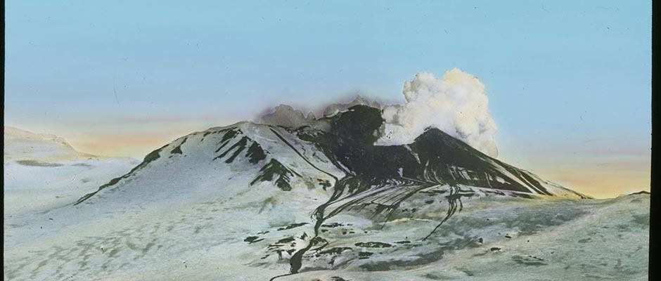
rivers draining the range.The Wrangell Mountains are a group of composite lava-cinder and exogenous
lava domes, resting on a platform of folded Paleozoic and Mesozoic rocks,
about 4,000 feet high. The higher mountains have been built up approximately
10,000 to 12,000 feet above the 4,000-foot platform on which they rest. Evi–
dence from fossils indicates that this area has been a center of volcanic
activity since the beginning of Tertiary time. The volcanoes, with the excep–
tion of Mount Wrangell, are now extinct. The present forms of the mountains are a
product of both volcanic activity (which normally produces symmetrical cones and
domes), and glacial sculpture. The form of the individual peak depends in part
on the type of volcanic activity (whether explosive or quiet flows), and the
time elapsed since the volcano was active, and during which glaciers have been
sculpturing it. Thus, Mount Wrangell is a broad, smooth, almost perfectly
preserved dome; Mounts Sanford and Drum, originally composite cones with steep
sides, now have great cirques gnawed out of their sides by glacial action, and
their cones are only partly preserved. Mounts Regal and Blackburn have been
extinct so long that glaciers have largely destroyed their original form.The Susitna-Cook Inlet Lowland (5) is a nearly flat, low-lying plain,
about 100 miles long from Homer to Talkeetna, and trends W. 30° E. to N. It
extends inland from the south coast of central Alaska and its southern end is
partly submerged beneath the waters of Cook Inlet. The seaward extension can
be followed for 100 miles southwest as Cook Inlet and Shelikof Strait. To
the north and northeast its structural continuation is the Broad Pass depression,
which can be followed for 60 miles. Branching to the east is another structurally
controlled depression, the Matanuska Valley, which geologically and physiographically
032 | Vol_I-0218
EA-I. Wahrhaftig: Physiography of Alaska
is closely related to the Susitna-Cook Inlet Lowland. At its widest part, at
Anchorage, the Susitna-Cook Inlet Lowland is 70 miles wide. Farther to the
southwest, however, it is only 40 miles wide and the Broad Pass depression at
the north end averages 10 miles in width. The Susitna-Cook Inlet Lowland is
bordered on the west and north by the Alaska Range, on the east by the Talkeetna
Mountains, and on the south by the Chugach and Kenai Mountains.The Susitna-Cook Inlet Lowland is drained by rivers flowing into Cook
Inlet. The largest, the Susitna River, enters the lowland between Talkeetna
and Curry, and flows slightly west of south for 80 miles before reaching Cook
Inlet. A large tributary of the Susitna, the Chulitna, drains part of Broad
Pass. The western part of the lowland is drained by the Yentna, another tributary
of the Susitna. Matanuska valley is drained by the Matanuska, which enters Knik
Arm at the northeast end of Cook Inlet.The surface of the Susitna Lowland is largely mantled by glacial and flufvia- ✓
glacial deposits, formed during Pleistocene time when a vast ice sheet covered
this area. Its topography, though minor in relief, is diversified; the northern
part has a great system of parallel north-south ridges, 10 to 50 feet high, and
looks as if it had been furrowed by a great plow. Between the Susitna Valley
and the Matanuska Valley is a broad, low, medial moraine extending southwest from
the corner of the Talkeetna Mountains; this is hilly country, with relief of as
much as 200 feet, and contains numerous lakes. The floor of lower Matanuska
Valley is a complex assemblage of outwash plains, sand plains, crevasse filling,
and terraces, all of glaciofluvial origin. Near the lower Matanuska River and
north of Knik Arm, the surface is mantled with a deposit of wind-blown loess,
which forms the rich agricultural land of the lower Matanuska Valley. The
shores of Cook Inlet are generally outlined by cliffs, 50 to 200 feet high.
The inlet itself is shallow, and two headward branches, Knik Arm and Turnagain
Arm, are almost silted up.
033 | Vol_I-0219
EA-I. Wahrhaftig: Physiography of Alaska
A few high hills and low mountains of granite rise in the center of
the Susitna Lo s w land just north of Cook Inlet. The most prominent of these ✓
is Mount Susitna, 4,397 feet high.Most of the rocks older than Pleistocene that are exposed in the
Susitna Lowland are poorly consolidated terrestrial Tertiary sedimentary
rocks known variously as the Kenai group, Chickaloon formation, or simply
as the coal-bearing formation. These rocks underlie a large part of the
Kenai Foreland, the low-lying northwestern part of Kenai Peninsula, and
crop out on the northern shore of Cook Inlet near Tyonek, where they are
deformed and dip to the east, away from the Alaska Range. Farther north they
are exposed on the banks of the Beluga, Yentna, Skwentna, and Susitna rivers;
in Peters Hills; and around the flanks of Mount Susitna. Extensive deposits
are well exposed in the Matanuska Valley, and small patches of Tertiary rocks
occur in the floor of Broad Pass. It is believed that the entire Susitna
Lowland is underlain by deformed Tertiary rocks, across which the essentially
plane surface of the lowland has been cut, probably by stream erosion.The Copper River Plateau (12) is a roughly equidimensional basin, about
70 miles in diameter, at an average altitude of about 2,000 feet. It is bounded
on the west by the Talkeetna Mountains, on the north by the Alaska Range, on
the east by the Wrangell Mountains, and on the south by the Chugach Mountains.
Two narrow prongs, extending east, wrap partly around the Wrangell Mountains.The Copper River plateau is drained by several rivers that rise in the
plateau and leave by great gorges through the surrounding mountains. Conse–
quently, drainage divides between important river systems cross the plateau
as inconspicuous water partings, commonly sinuous in plan, indicating an
accidental origin for a large part of the plateau. The southern and eastern
[ ?]
034 | Vol_I-0220
EA-I. Wahrhaftig: Physiography of Alaska
three-quarters of the plateau are drained by the Copper River and its tribu–
taries. The Copper River leaves the southeast corner of the plateau and flows
across the Chugach Mountains in a prominent glaciated gorge. The northwest
corner of the plateau is drained by one of the headwater tributaries of the
Susitna River. The Delta River rises on the north side of the plateau and
crosses the Alaska Range to empty into the Tanana. In the extreme southwest
corner of the plateau, the headwater tributaries of the Matanuska River rise
on the plateau side of the Talkeetna Mountains. Many lakes, perched on the
drainage divides, discharge their overflow into two river systems.The Copper River plateau is largely floored with Pleistocene glacial and
fluvioglacial deposits. The Copper River has cut 600 feet into these deposits
on the east side of the plateau without disclosing their base. In general,
deposits in the southern and central parts of the plateau, as exposed in the
Copper River valley, appear to be composed of fine gravel, sand, and silt, and
those of the peripheral areas and northern part of the plateau, of co u a rse ✓
gravel and sand. Much of the surface of the plateau is mentled with till;
the western part has many lakes in morainal depressions. In the northern and
western part of the plateau, many bedrock hills, composed of greenstone and
Paleozoic sedimentary rocks, rise above the plateau surface.Chugach-Kenai Mountains . The mountain chain that forms the south coast
of Alaska from about meridian 143° W. longitude to Turnagain Arm is known as
the Chugach Mountains. The mountains of Kenai Peninsula, south of Turnagain
Arm, although structurally and physiographically continuous with the Chugach
Mountains, are known as the Kenai Mountains. A southwest extension of the same
mountain chain appears in the mountains of Kodiak Island. This distinct physic–
graphic province is here called Chugach-Kenai Mountains.
035 | Vol_I-0221
EA-I. Wahrhaftig: Physiography of Alaska
The Chugach and Kodiak Island physiographic province is about 600 miles
long and ranges in width from 40 miles on Kodiak Island to 100 miles, east of
the Copper River. From 143° to 147° W. longitude its trend is roughly N. 70° W.,
and then changes abruptly to S. 40° W. and continues so throughout Kenai
Peninsula.The average height of the higher mountains in the Chugach Range is between
7,000 and 8,000 feet. A few peaks are higher, the highest mountain being Mount
Marous Baker, 13,250 feet high, which stands near the point where the range makes
it sharp bend in trend, and is only 13 miles from tidewater at the head of
College Fjord. Other high peaks of the Chugach Range are Mount Witherspoon,
12,023 feet, and Mount Miller, 11,000 feet, in the east part of the range.
Mountains in the Kenai Range are much lower, averaging between 3,000 and 5,000
feet in altitude. The highest peak (unnamed) in this range in 6,400 feet high.
The Kodiak Mountains average about 4,000 feet in height.The Chugach-Kenai Mountains are extremely rugged, the average relief of
valley walls being more than a mile. They have been intensely glaciated, the
serrate peaks of fretted uplands separated by U-shaped valleys. The Kenai and
Chugach Mountains are the loci of some of the greatest remaining ice fields of
the continent. The largest are the Harding icecap on Kenai Peninsula, the
Columbia ice fields in the vicinity of Mount Witherspoon, and the ice fields
that feed the Guyot and Bering glaciers in the eastern Chugach Mountains.
Many of the glaciers rising in these ice fields descend to tidewater.A portion of the coastal side of the Chugach Range near the sharp bend of
the mountains is partly submerged and forms the island-studded indentation of
the seacoast known as Prince William Sound. East of Prince William Sound the
coast is fairly straight, and the mountains are separated from the sea by a
036 | Vol_I-0222
EA-I. Wahrhaftig: Physiography of Alaska
narrow coastal shelf, but in Prince William Sound and west of it, the shores
are deeply frayed by extensive glacial fjords, and islands fringe the coast.
A broad strait separates the Kodiak Island mountains from the mainland.The bedrocks of the Chugach-Kenai Mountains consist almost entirely of
Mesozoic greywacke and argillite, but include some interbedded greenstone
and numerous granitic intrusives. These rocks are in most places tightly
folded, and elsewhere are thrown into broad open folds; everywhere, however,
they are affected by a well-developed cleavage which dips steeply and strikes
parallel to the trend of the mountains. Tertiary sedimentary rocks border the
south coast east of Copper River. On the southeast coast of Kodiak Island,
beds of Tertiary age are faulted and closely folded.Drainage lines and trends of valleys within the Chugach-Kenai Mountains
tend to follow two directions at right angles to each other. Where glacial
erosion met favorable conditions, as in the vicinity of Copper River and at
the northern end of the Kenai Peninsula, the mountains are broken into many
closely fitting rudely rectangular mountain masses separated by broad glacial
valleys and low passes. One major trend of valleys and drainage lines is normal
to the direction of the range. The other trend is roughly parallel to the axis
of the range, and apparently is controlled by the occurrence of weak or much
fractured rocks. These trends give a conspicuous reticulate pattern to the
drainage, and some of the glacial lakes, such as Kenai Lake, have a zigzag
pattern from following first one drainage direction and then the other.The streams that drain the Kenai Chugach Mountains are nearly all short
and swift. The Copper River, which rises in the Wrangell Mountains and Alaska
Range, flows across the Chugach Mountains from the Copper River plateau to the
sea at longitude 145° W.
037 | Vol_I-0223
EA-I. Wahrhaftig: Physiography of Alaska
St. Elias Range . Probably the most impressive mountain group on the
North American continent is the St. Elias Range, situated where the larger
part of Alaska joins the panhandle of southeastern Alaska. This range is
approximately 300 miles long and has a maximum width near Mount St. Elias
of about 120 miles. Its trend is about N. 45° W.The St. Elias Mountains have been almost inaccessible and their geology,
consequently, in largely unknown, yet it is believed that the core of the
range is made up of Palaeozoic metamorphic rocks and granitic intrusives,
associated with Mesozoic and Tertiary rocks along the south flank. The range
is out by many great faults, and is separated from a low coastal shelf of
Tertiary rocks by a great fault zone which has been a place of notable earth
movement as late as 1899 (21).The highest mountain in the St. Elias Range is Mount Logan, 19,850 feet,
in the southwest corner of Yukon Territory. Mount St. Elias, from which the
range takes its name, rises to an altitude of 18,008 feet directly from a
coastal terrace only 2,000 feet high. Twelve other mountains of the range are
higher than 14,500 feet, the highest altitude reached by any mountain in the
so-called continental United States. The southesterly extension of the St. Elias
Range is known as the Fairweather Range and is dominated by Mount Fairweather,
15,300 feet.British Columbia Coast Range (Coast Mountains) . The British Columbia
Coast Range province (3) includes all of the southeastern panhandle of Alaska
and extends for to the south and east following the coast of British Columbia.
Included in this province are the mountainous islands of the Alexander Archipelago,
which fringe the mainland coast of southeastern Alaska.
038 | Vol_I-0224
EA-I. Wahrhaftig: Physiography of Alaska
In southeastern Alaska the province is characterized by rugged mountains,
deeply indented fjords, and islands separated by many great channels and straits,
some of which are of great depth. The highest point in the Coast Range, in
Alaska, is Kates Needle (10,002 feet).Southeastern Alaska can be divided into three parallel longitudinal belts
in which the types of bedrock are reflected in part by the topography.The eastern belt, which includes the mainland and some bordering islands,
is a high mountain mass, capped by extensive ice fields. The general upland
altitude is from 6,000 to 8,000 feet. This area supported a much greater ice
field in Pleistocene time. As a consequence, it is deeply scored by tremendous
fjords, as much as 100 miles long. The mountain walls tower as much as 5,000
to 6,000 feet above waters that are themselves in places 1,500 to 2,000 feet
deep. The highest peaks stood above the Pleistocene ice field and are now
ar e ê t é e s and horns, whereas all land that was covered with ice now has rounded delete accent
summits. This eastern belt is underlain by the granodiorities of the Coast Range
batholith, and by a belt of crystalline metamorphic rocks which border the
plateau country on the northeast side of the Coast Range, cross the range in
Alaska to enter the Pacific Ocean. Two others, the Nass and Skeena, cross it
in British Columbia.West of the granitic mountain mass is a belt, 25 to 35 miles wide, of
low islands and broad channels that is generally underlain by Mesozoic and
Tertiary sedimentary and volcanic rocks. Few of the mountains in this belt
exceed 2,000 feet in altitude, and extensive low, flat areas are common. This
belt can be traced from the southeast, where it is continuous with Hecate Strait
in Canada, as far northwest as Chatham Strait which truncates the belt.
039 | Vol_I-0225
EA-I. Wahrhaftig: Physiography of Alaska
The western islands, including Prince of Wales, Baranof, and Chichagof
Islands, are higher, and are composed largely of Paleozoic and crystalline
rocks, but include some deformed Mesozoic rocks. Known mountain heights
range between 2,500 and 4,000 feet. Some mountains on Baranof Island are
reported to be higher. Mountains on these islands, excepting a few of the
highest, were overridden by a great ice sheet that originated in the higher
mountains to the east on the mainland. The summits consequently are rounded.
These islands also are deeply scored by fjords and channels. Along parts of
the seaward border of Chichagof and Baranof Islands is a strand flat, 5 miles
wide, with altitudes up to 300 feet behind which the higher mountains rise
abruptly.TOPOGRAPHIC DETAILS IN GLACIATED AND NON GLACIATED AREAS ✓
The Pacific Mountain System and the Brooks Range have been extensively
glaciated, whereas the great interior portion of Alaska has been glaciated
only locally. Topographic details in the two types of regions are remarkably
contrasted and reflect the different dominant cold-climate erosional processes
that have been active in sculpturing the topography: glaciation in one area,
solifluction and creep in the other.In the two glaciated mountain regions, valleys are commonly straight and
have U-shaped cross-profiles. Where glaciation has been recent, the valley
walls bear grooves parallel to the valley trend. Mountain tops that projected
above the ice are sharp horns and ar e ê t é e s[?], crowned with numerous pinnacles and ✓ arête
spires. Those that did not project above the ice have rounded and mammillated
surfaces, often complex in detail, that reflect every difference in rock hardness.In the nonglaciated mountain regions, valleys are more commonly winding.
The ridge tops are usually broadly rounded, and slopes are steepest toward the
040 | Vol_I-0226
EA-I. Wahrhaftig: Physiography of Alaska
base. Where flood plains are absent, valleys are V-shaped in cross section.
Striping, if present, trends directly down the slope. Outcrops are scarce,
and surface fragments cannot always be relied upon as an indication of the
type of bedrock because of extensive hillside creep and solifluction.
Locally, steep-sided bizarre rock monuments crown the ridge crests.The lowland areas of glaciated regions commonly contain hummocky deposits
of ground moraine, and many lakes, some of which are deep. The lakes are
fixed in position. Anastomosing patterns of gravel and sand plains, which
were glacial moltwater channels, are superposed on the hummocky topography.The lowlands of the unglaciated areas in much of Alaska are underlain by
permafrost at shallow depths. Such areas commonly show little relief, except
for occasional sand dunes and frost mounds, and are crossed by rivers which
wind in tortuous meanders or, branching and rebranching, form anastomosing
and meandering streams across the flats. Many flats are dotted with lakes,
some of which originate as oxbows (abandoned meanders) and others through the
thawing of permafrost. The latter are commonly oval in outline, and enlarge
through thawing and undermining of the banks, particularly on their leeward sides.PHYSIOGRAPHIC HISTORY OF ALASKA
The physiographic history of Alaska, like the geologic history, is known
only sketchily. Practically all present physiographic knowledge is based on
inferences from reconnaissance surveys in which physiography was studied only
incidentally to a study of the mineral deposits in bedrock and placers. These
inferences are not sufficiently widely accepted at the present time (1950) to
warrant a statement on the physiographic history in this article.
041 | Vol_I-0227
EA-I. Wahrhaftig: Physiography of Alaska
Alaska present s some physiographic features that have posed problems and ✓
have aroused interest in explanations of the topography and drainage patterns
of Alaska. Among these physiographic problems are: the origin of the great
Yukon River system which crosses ridges and valleys without much regard for
existing topography; the origin of the extensive flat alluvium-covered plains,
surrounded by mountains, that are known in may parts of Alaska; and the origin
of the extensive deposits of silt and muck that mantle the low hills of
interior Alaska.
042 | Vol_I-0228
EA-I. Wahrhaftig: Physiography of Alaska
BIBLIOGRAPHY
1. Black, R.F. and Barkedale, W.L. “Oriented lakes of northern Alaska,”
J.Geol . vol.57, pp.105-118, 1949.2. Brooks, A.H. The Geography and Geology of Alaska. With a Section on Climate
by Cleveland Abbe, Jr., and a Topographic Map and Description Thereof
by R.U. Goode . Wash., D.C., G.P.O. 1906. U.S.Geol. Surv. Prof. Pap . 45.3. Buddington, A.F., and Chapin, Theodore. Geology and Mineräl Deposits of
Southeastern Alaska . Wash., D.C., G.P.O., 1929. U.S. Geol.Surv.
Bull . 800.4. Capps, S.R. The Chisana-White River District, Alaska . Wash., D.C., G.P.O.,
1916. Ibid . 630.5. ----. Geology of the Alaska Railroad Region . Wash., D.C., G.P.O., 1940,
pp. 25-27, 118-29, 130-33, and Pl. 2. Ibid . 907.6. Eakin, H.M. The Cosna-Nowitna Region, Alaska . Wash., D.C., G.P.O., 1918,
pp. 42-50. Ibid . 667.7. Eardley, A.J. “Unconsolidated sediments and topographic features of the
lower Yukon Valley,” Geol.Soc.Amer. Bull . vol.49, pp. 303-42, 1938.8. Elias, M.M., and Vosburgh, R.M. Terraine and Permafrost in the Galena Area,
Alaska . Wash.,D.C., G.P.O., 1946. U.S.Geol.Surv. Permafrost Progr o am —
Progress Report No.1.9. [k?] Leffingwell, E. de K. The Canning River Region, Northern Alaska . Wash., —
D.C., G.P.O., 1919, pp. 166-77. U.S.Geol.Surv. Prof. Pap . 109.10. MacNeil, F.S., Mertie, Jr., J.B., and Pilsbry, H.A. “Marine invertebrate
faunas of the buried beaches near Nome, Alaska,” J.Paleont . vol.17,
pp.69-96, Jan., 1945.11. Maddren, A.G. The Koyukuk-Chendaler Region, Alaska . Wash., D.C., G.P.O.,
1913, pp.11-27, 56-67. U.S.Geol.Surv. Bull . 532.12. Mendenhall, W.C. Geology of the Central Cooper River Region, Alaska . Wash.,
D.C., G.P.O., 1905, pp.16-22, 79-90. U.S.Geol.Surv. Prof. Pap . 41.13. Martie, Jr., J.B., and Harrington, G.L. The Ruby-Kuskokwim Region, Alaska .
Wash., D.C., G.P.O., 1924, pp. 41-55, 80-109. U.S.Geol.Surv. Bull . 754.14. Mertie, Jr., J.B. The Yukon-Tanana Region, Alaska . Wash.,D.C., G.P.O., 1937,
pp.12-32, 178-98, 235-37. Ibid . 872.15. Moffit, F.H. Geology of the Eastern Part of the Alaska Range and Adjacent
Areas. Ibid. (In Press.)
043 | Vol_I-0229
EA-I. Wahrhaftig: Physiography of Alaska
16. ----. Geology of the Chitina Valley and Adjacent Area, Alaska . Wash.,
D. C., G.P.O., 19 4 3 , pp.9-14, and Pl.2. Ibid . 894. —17. P e é w e é , T.L. Permefrost Investigations, Fairbanks, Alaska . Wash., D.C.,
G.P.O., 1948. U.S.Geol.Surv. Preliminary Permafrost Report .
(Published by U.S. Army Map Service.)18. Schrader, F.C. A Reconnaissance in Northern Alaska . Wash., D.C., G.P.O.,
1904, pp.42-45. U.S.Geol. Surv. Prof. Pap . 20.19. Smith, P.S., and Eakin, H.M. A Geologic Reconnaissance in Southeastern
Seward Peninsula and the Norton Bay-Nul ta at o Region, Alaska . Wash., —
D.C. G.P.O., 1911, pp.20-32. U.S.Geol.Surv. Bull . 449.20. ----, and Mertie, Jr., J. B. Geology and Mineral Resources of Northwestern Geology and Mineral Resources of Northwestern —
Alaska Alaska . Wash.,D.C., G.P.O., 1930 pp.27-51. Ibid . 815.21. Tarr, R.S., and Butler, B.S. The Yakutat Bay Region, Alaska. Wash.,D.C.,
G.P.O., 1909. U.S. Geol.Surv. Prof. Pap . 64.22. U.S. Geological Survey. Oil and Gas Sheet No.106. (In press.)
23. Wahrahaftig, Clyde. “Preliminary report on the physiographic history of part
of the Alaska Range.” Wash.Acad.Sci. J . vol.36, pp.134-35, 1946.24. Wallece, R.E. Terraine Analysis in the Vicinity of Northway, Alaska, with
Special Reference to Permafrost . Wash.,D.C., G.P.O., 1946.
U.S.Geol.Surv. Permafrost Report . No.3. (Mimeographed.)Clyde Wahrheftig